The Peralta Stone Maps, Real Maps to Lost Gold Mines or Cruel Hoax?

Do you think the Peralta stone maps are genuine, or fake?


  • Total voters
    121
Interesting, but not entirely correct.

The mining laws weren't originally meant to deal with only silver (even the percentages which changed from edict to edict).

As early as 1383:

All mines of silver, and gold, and lead, and of any other metal, whatsoever kind it may be, in our Royal Seignory, shall belong to us; therefore, no one shall presume to work them without our special license and command..........

.......... and all that shall be found and taken out from the said Mines shall be divided as follows: First, that there shall be delivered and paid therefrom to the person who has taken out the mineral, all the expenses which may be incurred in excavating and extracting it; and of that which remain after deducting said expenses, the third part shall belong to the person who has taken it out, and the other two-thirds to ourself.

From 1563:
Paraphrasing

Silver Mines less than 1 mark per quintal= 1/8th
Silver Mines between 1 and 3 marks per quintal= 1/4th
Silver Mines between 3 and 6 marks per quintal= 1/3rd
Silver Mines Over 6 marks per quintal= 1/2
Gold Mines 1/2
All those are before deducting for expenses

Art. 77. Also, we ordain and command, that no person shall presume to treat for, contract, sell or purchase gold, in dust, in bars, in ingots (vergas) of the gold which shall be taken out, and who shall act as the Trusty to weigh it (Fiel del Peso), and he shall smelt, weigh and stamp the same with our Royal stamp aforesaid, in the presence of our said Administrator, or in the presence of the person appointed by him, and the proportion which shall belong to us shall be given and delivered to our Treasurer who for that purpose......

Gotta go, I will finish later.

Best - Mike
 

Mike,

I believe Lacy addresses that in his course, but I believe the opening comment in our current discussion, was in error.

Take care,

Joe
 

so...somehiker...you found this medicine wheel in the superstitions?
do you have a before photograph please?

Hi Don:
It was a pleasure meeting you at the Rendezvous. I found your attitude and sense of humor entertaining, to say the least.
I'll give you a holler next time I'm planning a trip. Maybe take you out to see it for yourself if you're up to it.
It's a nice day hike with lots of other things to see.
I do have a couple of photos which show the rocks in the opening, but it might be problematic to share them at this time.
They weren't just there, but were arranged in a rather artistic fashion.

Regards:Wayne
 

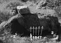
Here are two more photos of things I suspect were carved.
They are both approximately the same size as the one under the overhang, but are fully exposed to the elements on top of a ridgeline.
About 4-500 yards from the one Tim posted the photo of, which by the way, I have never mentioned or posted myself. Even though I have spoken of, and posted photos of the mine some time last year.
Manmade or natural ?
Recent or older ?
I will post the rest of the photo later, after I see your opinions.

Another small cross....

View attachment 100_1492 signpost cross.bmp

And the number 2....

View attachment 100_1492 signpost 2.bmp
 

Last edited:
Real or a Hoax I'm trying to stay on the fence, gives a good view of both sides of the discussion. I just hope an open mind does not lead to an empty hole.
 

Well, I cant even see a number 2, but I may need new glasses.
First cross looks mother nature.
 

Well I have trouble seeing some thing also. But when I visited the site with Wayne right away I pointed to the #3 Plain as day and big!
 

Thanks for the comments guys. All of them. I enjoy hearing what people think of what I post.
Regardless of the position they might take.
I've posted a photo of this rock before, and the markings and carvings ARE faint, barely legible as a clue their age.
But when I shared it two or three years ago, I also stated how the dagger seemed to indicate there was another trail not shown on the Map Stones, departing the main trail at a point identified with an X (upper X) on the lower Trail Stone. I find it interesting that Robert Garman's drawing of the Stone Maps shows such a trail.

1847 signpost rock2.jpg

View attachment Garmin Map trail 2.bmp

And the rock above, from slightly to the right....

View attachment 100_1492 signpost rock.bmp
 

Last edited:
Interesting pictures to say the least.
Now, where do these differences in maps show up. I have never seen that map with those markings any where.
 

G'd evening sgt, in which of the two pictures with the yellow square is it?? Hikers post #1725.

Don Jose de La Mancha

It's not in those pictures Don.
It's on the body of the Horse as shown on the H/P stone, quite easy to see from a distance.
Above and a bit to the left of the big boulder that's shaped like a reverse "D".
And also as shown, at the same location on the lower Trail Stone.
As Frank said, he noticed it as soon as I pointed out the location of the boulder.
In much the same way as Tim spotted the "teepee" symbol up on the cliff face while we were standing in front of the big "E" with the other "3".
 

007.JPG
Thanks for the comments guys. All of them. I enjoy hearing what people think of what I post.
Regardless of the position they might take.
I've posted a photo of this rock before, and the markings and carvings ARE faint, barely legible as a clue their age.
But when I shared it two or three years ago, I also stated how the dagger seemed to indicate there was another trail not shown on the Map Stones, departing the main trail at a point identified with an X (upper X) on the lower Trail Stone. I find it interesting that Robert Garmin's drawing of the Stone Maps shows such a trail. Somehiker, you taught me something. Although I may be good at finding the bigger things like caves, waterfalls and previous hikers trash, I need to slow down and look for the finer details in everything I come across. Chuck 123

View attachment 896010

View attachment 896019

And the rock above, from slightly to the right....

View attachment 896026
 

Interesting pictures to say the least.
Now, where do these differences in maps show up. I have never seen that map with those markings any where.

Garman's drawing was recently posted elsewhere by Tom K., as mentioned in this thread previously.
He seems to have a great deal of interest in the stones and actually has three drawings by Garman.
Maybe someday he will post them all here.
 

Sometimes I have the same problem Chuck.
Helps to explore a different area once in a while, even if you have no good reason to.
 

I,d like to hook up with you the next time you come down to the lower 48.
 

I,d like to hook up with you the next time you come down to the lower 48.

Just might be possible, depending on timing. Sometimes, circumstances have me down on very short notice, as both Tim and Frank can attest.
Lots to see out there in the hills. And I've still got plenty of ground to cover yet.
 

Top Member Reactions

Users who are viewing this thread

Back
Top