The lost Dutchman’s gold mine location

Matthew Roberts

I've not heard of this. Exactly which authors (their books) have made the statement of Waltz possibly had been in that organized party - which ended up in the Sierra Ancha Range?

To be honest, out of all that I've been able to obtain regarding Jacob Waltz; I've never seen a reference to this, other than the Mining Club of the Southwest Foundation - to which seems to be your source of reference and in there - only tells of the organized expedition, not the people involved (the miners).

Mining Club of the Southwest Foundation Tucson, Arizona

-SpartanOC
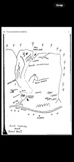
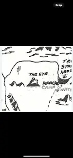
There is no record of everyone who was involved in the Safford - Minor expedition. There is only speculation Waltz may have been with the group. Some 200 miners made up the group. Waltz may or may not have been one of them. No one can say for certain one way or the other.

I believe TE Glover speculated on this possibility as did TJ Kollenborn, CL Worst among others.

I believe (my opinion)there is a good chance Waltz may have accompanied the expedition and may have found his mine in the Superstitions as he worked his way back toward Phoenix.

It is all pure speculation and as I said before, it is my opinion Waltz mine is in the Superstition Mountains.

One thing to always keep in mind about recorded evidence is that the lack of evidence is NOT evidence of the lack.
 

Jacob Waltz gave Julia Thomas a cipher map days before he died. A map that was handed down to him by a Peralta family member. He didn’t explain the map to Julia, but what he did do was insert the eye of the needle rock structure on the map describing the exact location of where one could locate the eye which would direct them to the rock horse area that contained the hidden canyon. He also inserted the four peaks across from it which meant that the map was being used to describe a large area as well as a small area that contained cactuses 🌵. The map’s outline is based on the 9 square miles area of the sunken summit located east of the Sierra Ancha’s saddle peak, therefore the map was useless anywhere except the eastern side of the saddle peak. Julia Thomas had to depend on Holmes and Rhinehardt working together to identifying and verify the saddle that would help Julia with her map. Why? Because Jacob Waltz wanted them to work as a team. Holmes was supposed to figure out the direction and clue to the saddle. Rhinehardt was supposed to verify the view looking back at the needle. Julia Thomas could then use the map from the saddle’s high point by looking down on the eastern sunken summit. Her map describes the 9 square mile area that surrounds the rock horse including the eye of the needle located in the northwest corner of the sunken summit. The eye over looks the ground level area that hides the canyon. From the high point you can spot the hidden canyon. The cipher stone map maker spent a lot of time in the area of the rock horse. He took the time to select specific natural features that would identify the 9 square mile area. He was very selective in choosing certain features which could also imitate or simulate a large area that surrounds the needle rock structure. He used a natural water drain trail feature that resembled the Apache Indian trail that came from the north crossing the salt river valley which would end behind the needle rock structure. With the insertion of the needle, the cave, and the Indian campground he could deceive the reader into thinking that there were only looking at a large area map center around the superstitious mountains not noticing that the maps outlined pertained to the immediate area surrounding the rock horse. The individual who created the map had knowledge and understanding of what it takes to create a cipher. In order to lead his organization to the location safely, he had to provide a large area map. This allowed him to insert other cipher information with instructions to be followed. Being able to define the two maps is very important in locating the LDM. But the cipher map contains more information hidden by the use of symbolic cipher symbols which I will explain next because historians like myself want to record how the Templars used their cipher symbols in order to decipher other maps.
 

Attachments

  • IMG_1237.png
    IMG_1237.png
    217.5 KB · Views: 35
  • IMG_1238.png
    IMG_1238.png
    374.4 KB · Views: 34
Jacob Waltz gave Julia Thomas a cipher map days before he died. A map that was handed down to him by a Peralta family member. He didn’t explain the map to Julia, but what he did do was insert the eye of the needle rock structure on the map describing the exact location of where one could locate the eye which would direct them to the rock horse area that contained the hidden canyon. He also inserted the four peaks across from it which meant that the map was being used to describe a large area as well as a small area that contained cactuses 🌵. The map’s outline is based on the 9 square miles area of the sunken summit located east of the Sierra Ancha’s saddle peak, therefore the map was useless anywhere except the eastern side of the saddle peak. Julia Thomas had to depend on Holmes and Rhinehardt working together to identifying and verify the saddle that would help Julia with her map. Why? Because Jacob Waltz wanted them to work as a team. Holmes was supposed to figure out the direction and clue to the saddle. Rhinehardt was supposed to verify the view looking back at the needle. Julia Thomas could then use the map from the saddle’s high point by looking down on the eastern sunken summit. Her map describes the 9 square mile area that surrounds the rock horse including the eye of the needle located in the northwest corner of the sunken summit. The eye over looks the ground level area that hides the canyon. From the high point you can spot the hidden canyon. The cipher stone map maker spent a lot of time in the area of the rock horse. He took the time to select specific natural features that would identify the 9 square mile area. He was very selective in choosing certain features which could also imitate or simulate a large area that surrounds the needle rock structure. He used a natural water drain trail feature that resembled the Apache Indian trail that came from the north crossing the salt river valley which would end behind the needle rock structure. With the insertion of the needle, the cave, and the Indian campground he could deceive the reader into thinking that there were only looking at a large area map center around the superstitious mountains not noticing that the maps outlined pertained to the immediate area surrounding the rock horse. The individual who created the map had knowledge and understanding of what it takes to create a cipher. In order to lead his organization to the location safely, he had to provide a large area map. This allowed him to insert other cipher information with instructions to be followed. Being able to define the two maps is very important in locating the LDM. But the cipher map contains more information hidden by the use of symbolic cipher symbols which I will explain next because historians like myself want to record how the Templars used their cipher symbols in order to decipher other maps.
Has anyone factored in the fact we won’t be looking for a topic cave opening rather wood logs coming from the ground legend has it he buried it and after the first rain you couldn’t tell it was there he himself is to have said you could drive a mule train right over it and never know it was there
 

Jacob Waltz gave Julia Thomas a cipher map days before he died. A map that was handed down to him by a Peralta family member. He didn’t explain the map to Julia, but what he did do was insert the eye of the needle rock structure on the map describing the exact location of where one could locate the eye which would direct them to the rock horse area that contained the hidden canyon. He also inserted the four peaks across from it which meant that the map was being used to describe a large area as well as a small area that contained cactuses 🌵. The map’s outline is based on the 9 square miles area of the sunken summit located east of the Sierra Ancha’s saddle peak, therefore the map was useless anywhere except the eastern side of the saddle peak. Julia Thomas had to depend on Holmes and Rhinehardt working together to identifying and verify the saddle that would help Julia with her map. Why? Because Jacob Waltz wanted them to work as a team. Holmes was supposed to figure out the direction and clue to the saddle. Rhinehardt was supposed to verify the view looking back at the needle. Julia Thomas could then use the map from the saddle’s high point by looking down on the eastern sunken summit. Her map describes the 9 square mile area that surrounds the rock horse including the eye of the needle located in the northwest corner of the sunken summit. The eye over looks the ground level area that hides the canyon. From the high point you can spot the hidden canyon. The cipher stone map maker spent a lot of time in the area of the rock horse. He took the time to select specific natural features that would identify the 9 square mile area. He was very selective in choosing certain features which could also imitate or simulate a large area that surrounds the needle rock structure. He used a natural water drain trail feature that resembled the Apache Indian trail that came from the north crossing the salt river valley which would end behind the needle rock structure. With the insertion of the needle, the cave, and the Indian campground he could deceive the reader into thinking that there were only looking at a large area map center around the superstitious mountains not noticing that the maps outlined pertained to the immediate area surrounding the rock horse. The individual who created the map had knowledge and understanding of what it takes to create a cipher. In order to lead his organization to the location safely, he had to provide a large area map. This allowed him to insert other cipher information with instructions to be followed. Being able to define the two maps is very important in locating the LDM. But the cipher map contains more information hidden by the use of symbolic cipher symbols which I will explain next because historians like myself want to record how the Templars used their cipher symbols in order to decipher other maps.
And if I recall all the stories say he gave her clues. He also gave the same clues to Dick Holmes,She drew the maps as a way to generate a profit after she went broke searching for the mine.The Peralta Stones didn’t emerge until the 1940’s and could very well be fake and done in an effort to keep people from the clues that were left.There are two area that make a lot of sense based on the it is in a north south cannon clue.But again he said he buried it under a few feet of dirt and it was undetectable after the first rains that was over 140 years ago so where ever the mine actually is it is hidden from the naked eyes. The area I’ve enclosed definitely fits you can see the trail from my mine but not my mine from the trail
 

Attachments

  • IMG_0481.png
    IMG_0481.png
    1.7 MB · Views: 34
  • IMG_0482.png
    IMG_0482.png
    1.6 MB · Views: 35
So I heard that many individuals complained about people following them when searching for the Dutchman’s goldmine in the superstitious mountains which spoiled their search many times. A friend once asked Jacob Waltz if he described a starting point. He gave him a cipher message by saying that from the starting point he could reach the goldmine and back in one day. Jacob was referencing the starting point that was on the cipher map given to Julia Thomas. The Julia Thomas map was created by a secret organization who knew how to cipher maps with instructions to follow. Even though the map was found on a rock in the eastern foothills of the superstitious mountains. The map instructions were to locate the Apache crossing first. Then the symbolic cross on the map, that is slightly of set, would direct them to follow the trail around the superstitious mountains towards the south which would take a turn towards the northeast in order to locate two crosses that were hiding the other cipher stones we call the Peralta stones. This location was 9 mile south of the superstitious mountains. The information is ciphered on the map. The map instructed the organization to stay on the trail in the direction of the southern part of the salt River valley. Why? Because the map maker knew that no one would follow them if they approached the goldmine from the south Salt River valley through a river crossing call the Nail crossing. The sections of the river was described on the lower part of the map with instructions to head north and climb the Sierra mountain range. This is the same route that Jacob described to his friend that intercepted the military trail going to Fort Apache. This is the same trail that went around a farm. This the same trail that leads you to the gorge in the southern part of the eastern Sierra Ancha summit in the direction of Aztec Peak. It was the best and safest route for no one to follow you coming out of the superstitious mountains. Jacob Waltz read the map and knew the safest route and was trying to pointed out secretly to his friends but they didn’t understand the cipher map. The map leads you to the rock horse that contains the hidden canyon with two circular funnel openings in the top portion of the canyon. The northern funnel opening contains the ledge that leads to the hidden goldmine. Jacob Waltz hid the main entrance to get access to the ledge from the top. Because there was another secret entrance to the south cover by brush which he used so no one would know. So let be said that people will follow you, easily, if you try to cross the superstitious mountains in search of his goldmine. There will be more to learn about this cipher map at a later time. But Not today. At the moment I’ll be working on the Aztec treasure calendar cipher map. Bet you didn’t know the Aztec temple priest order a rock structure in form of a calendar in 1517 few years before the Spaniards conquest as a gift to the secret Templar organization to use in order to know the whereabouts and protect the treasure. Impressive!
 

So I heard that many individuals complained about people following them when searching for the Dutchman’s goldmine in the superstitious mountains which spoiled their search many times. A friend once asked Jacob Waltz if he described a starting point. He gave him a cipher message by saying that from the starting point he could reach the goldmine and back in one day. Jacob was referencing the starting point that was on the cipher map given to Julia Thomas. The Julia Thomas map was created by a secret organization who knew how to cipher maps with instructions to follow. Even though the map was found on a rock in the eastern foothills of the superstitious mountains. The map instructions were to locate the Apache crossing first. Then the symbolic cross on the map, that is slightly of set, would direct them to follow the trail around the superstitious mountains towards the south which would take a turn towards the northeast in order to locate two crosses that were hiding the other cipher stones we call the Peralta stones. This location was 9 mile south of the superstitious mountains. The information is ciphered on the map. The map instructed the organization to stay on the trail in the direction of the southern part of the salt River valley. Why? Because the map maker knew that no one would follow them if they approached the goldmine from the south Salt River valley through a river crossing call the Nail crossing. The sections of the river was described on the lower part of the map with instructions to head north and climb the Sierra mountain range. This is the same route that Jacob described to his friend that intercepted the military trail going to Fort Apache. This is the same trail that went around a farm. This the same trail that leads you to the gorge in the southern part of the eastern Sierra Ancha summit in the direction of Aztec Peak. It was the best and safest route for no one to follow you coming out of the superstitious mountains. Jacob Waltz read the map and knew the safest route and was trying to pointed out secretly to his friends but they didn’t understand the cipher map. The map leads you to the rock horse that contains the hidden canyon with two circular funnel openings in the top portion of the canyon. The northern funnel opening contains the ledge that leads to the hidden goldmine. Jacob Waltz hid the main entrance to get access to the ledge from the top. Because there was another secret entrance to the south cover by brush which he used so no one would know. So let be said that people will follow you, easily, if you try to cross the superstitious mountains in search of his goldmine. There will be more to learn about this cipher map at a later time. But Not today. At the moment I’ll be working on the Aztec treasure calendar cipher map. Bet you didn’t know the Aztec temple priest order a rock structure in form of a calendar in 1517 few years before the Spaniards conquest as a gift to the secret Templar organization to use in order to know the whereabouts and protect the treasure. Impressive!

Ramiro

Looks as if you are still holding to the Sierra Ancha Mountains region as the location of the LDM. Do you honestly think Waltz went that far - let alone having that kind of strength in getting there? What evidence do you really have that would show, Waltz going up that far North? As far as I know, there is no evidence of Waltz ever being in that particular area and no documentation of him ever being able to walk/ride that far. Again, from some of the info I've been able to collect, never shows Waltz up in that region for any reason. It just doesn't make sense - as no other discovered information would back up that theory. Again, as I've said in the past, the area you are referring to MIGHT have something its hiding - but to equate it to the LDM just seems weak.

That all being said; please continue as many of us are always interested in theories, thoughts and possible facts. It's imparative that we all keep an open mind at the end of the day.

-SpartanOC
 

Top Member Reactions

Users who are viewing this thread

Back
Top