The Peralta Stone Maps, Real Maps to Lost Gold Mines or Cruel Hoax?

Do you think the Peralta stone maps are genuine, or fake?


  • Total voters
    121
One might look for an "infield triangle" within the boundaries of said blade. A = Apex.......tree and stone together.

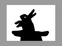
Most folks would think you were cracked up if you told them you needed a hot air balloon back in the day; a forked tree stump is the marker they made where one would tie the mooring line off at. I wonder what would happen at sunrise or sunset with the shadow and all that?

If ya stood with your back to the setting sun.
And raised your arm,with your fingers held just the right way.
You could see the shadow of a bunny rabbit....I'll bet.
But it takes practice.
 

Attachments

  • new-img-08.jpg
    new-img-08.jpg
    12.4 KB · Views: 129
Still think this is neat,though.

100_1179sm.png

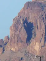
The Priest on the other hand,reminds me of the "Crazy Horse" Memorial.
Not as big,mind you,but the same layout.The location is perfect as well.
 

Last edited:
Cubber, you posted -->but heck, what do I know - I haven't found anything either
smiley.gif
.
~~~~~~~~~~~~~~~~~~

How can you say such a thing, snifff, you found ME !
~~~~~~~~~~~~~~~~~~~~~~~~~~~~

Side thingie, you posted somewhere in the Tayopa series -->

He said, "Well, maybe I oughtn't to tell you this, but I think I will. If you're going up into that country, there's a lost mine up there called la Mina Tayopa which is famous for its rich ore." He said nobody else knew where it was, but that he'd give me the description of how to find it. Schmidt said to go to San Luis Barbarocas, climb the mountain north of the river, that the mine was a short distance below on the Rio Mayo. The miners used to come down to San Luis Barbarocas to get milk in the morning, so it couldn't have been more than a few miles away. There was supposed to be a cache up there mined by the Jesuits and abandoned when they left.

On your way up, you would see these three peaks and on the back side of the third peak you would find an iron door. If you could go through that iron door, you'd find the cache of gold and silver. "Well," Schmidt said, "don't try to bring it out by yourself. You'll get killed on the way. The people would all know you had it and you'd be robbed. Come back and notify us and we'll get it out." So Schmidt told me all about the Tayopa Mine. I finally got up to San Luis, and sure enough, there were three peaks up there. Maybe there's an iron door there too, but probably a tree has grown up since the Jesuits left in 1767.
~~~~~~~~~~~~~~~~~~~~~~~~~~~~

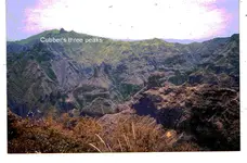
I really didn't pay much attention at first, but yesterday, while I was checking some photographs, I found that indeed there is a mt with three peaks on top, and it lies just south of the entrance of the Tayopa /San Luis Barbarocos Barranca. Go north form there, and you are in Tayopa, in the vicinity of the metal door. So the instructions were correct, but you can spend a lifetime in there and never find the metal door. See sttachments.

I don't remember in which thread ion Tayopa that you posted this (#13, Jul., 08, 2010), but let me know and I will remove it from here and put in it's proper place.

Don Jose de La ManchaCubber's three peaks ©@®.jpg
 

Last edited:
If ya stood with your back to the setting sun.
And raised your arm,with your fingers held just the right way.
You could see the shadow of a bunny rabbit....I'll bet.
But it takes practice.

No trees in the desert and nothing to cast a shadow either. 180 feet up at sunrise on The witch's equinox

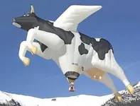
and bingo; one silver mine......:laughing7:.........How big of a balloon did you have in mind?
 

Last edited:
No trees in the desert and nothing to cast a shadow either. 180 feet up at sunrise on The witch's equinox

and bingo; one silver mine......:laughing7:.........How big of a balloon did you have in mind?

This'll do.when cows fly.jpg
 

Cubber, you posted -->but heck, what do I know - I haven't found anything either
smiley.gif
.
~~~~~~~~~~~~~~~~~~

How can you say such a thing, snifff, you found ME !
~~~~~~~~~~~~~~~~~~~~~~~~~~~~

Side thingie, you posted somewhere in the Tayopa series -->

He said, "Well, maybe I oughtn't to tell you this, but I think I will. If you're going up into that country, there's a lost mine up there called la Mina Tayopa which is famous for its rich ore." He said nobody else knew where it was, but that he'd give me the description of how to find it. Schmidt said to go to San Luis Barbarocas, climb the mountain north of the river, that the mine was a short distance below on the Rio Mayo. The miners used to come down to San Luis Barbarocas to get milk in the morning, so it couldn't have been more than a few miles away. There was supposed to be a cache up there mined by the Jesuits and abandoned when they left.

On your way up, you would see these three peaks and on the back side of the third peak you would find an iron door. If you could go through that iron door, you'd find the cache of gold and silver. "Well," Schmidt said, "don't try to bring it out by yourself. You'll get killed on the way. The people would all know you had it and you'd be robbed. Come back and notify us and we'll get it out." So Schmidt told me all about the Tayopa Mine. I finally got up to San Luis, and sure enough, there were three peaks up there. Maybe there's an iron door there too, but probably a tree has grown up since the Jesuits left in 1767.
~~~~~~~~~~~~~~~~~~~~~~~~~~~~

I really didn't pay much attention at first, but yesterday, while I was checking some photographs, I found that indeed there is a mt with three peaks on top, and it lies just south of the entrance of the Tayopa /San Luis Barbarocos Barranca. Go north form there, and you are in Tayopa, in the vicinity of the metal door. So the instructions were correct, but you can spend a lifetime in there and never find the metal door. See sttachments.

I don't remember in which thread ion Tayopa that you posted this (#13, Jul., 08, 2010), but let me know and I will remove it from here and put in it's proper place.

Don Jose de La ManchaView attachment 625250

I'm not sure if I found you, you found me or more than likely we just both ended up at the same place at the same time :).

I appreciate you naming the peaks after me, but it's misplaced unfortunatley as I'm not the one who posted what you quoted - I don't know who did, but sadly it wasn't me :(.

Keep up the work on Tayopa - I expect a personal tour one of these days! It would take a lot to get me to go to Mexico these days, but a glimpse of a long forgotten gold deposit and/or lost "treasures" would probably do it :)
 

OK, bear with me....I'm new. This is most assuredly a fascinating story. I've skimmed all hundred-odd pages. I've seen a lot of bickering between people regarding their evidences and theories, but didn't really see any actual evidence that there is really a treasure. Not trying to be a smartass...but, have I missed something?
 

OK, bear with me....I'm new. This is most assuredly a fascinating story. I've skimmed all hundred-odd pages. I've seen a lot of bickering between people regarding their evidences and theories, but didn't really see any actual evidence that there is really a treasure. Not trying to be a smartass...but, have I missed something?

Therein lies the crux of the problem with treasures and treasure hunting. If you post what most of us would consider to be irrefutable evidence that you found something valuable, you run the very real risk of it getting taken away from you eithe by the government or by lawyers somewhere along the line.

All you have to do is watch the crazy legal battles that occur every year when someone happens to find a sunken treasure ship or other fabulous treasure.

It comes down to the fact that you either get to know the person well enough to trust that they REALLY DID find something, or you don't - in the end it doesn't matter to most of us cause for some sick reason it's often the HUNT that really intrigues us :)
 

Ok so I have what seems to me a simple question, but some of you that are experts in these mountains might think this is ******ed. So here goes nothing. Ok doing my research the same thing comes up the mine is lost on a cliff that can only been seen when the sun hits it just right. Also weaver's needle or (sombreo peak) is always linked to be seen from the mine. I have heard Sombreo Peak at it was once named is south of the mine. And then you have the 4 peaks. So I am taking it that everyone who has looked in those mountains have looked around those areas. Now I know it would take a lifetime to cover every square inch of that place and if the mine is covered you may never find it even if you did look everywhere. So my question since never having walked those mountains before is this. Where are one or two areas in those mountains that nobody goes. Or where is a few areas that only a few people have been. Me and my wife are going to start camping and hiking out there at the end of this month. Plan on spending a few weeks at a time out there. We would like to go to a place where there are not a lot of people. Also would it be wise to bring a gun.
 

mullnax:

The best advice I could give to you and your wife,would be to delay your plans until at least mid October,when the temperatures will be less dangerous.
This will also give you more time to research those areas which you may find of interest,based on suggestions offered by those who may,in the meantime, respond to your questions.Most of the places where few have been are less travelled for good reason.They are remote,high up,and extremely rugged.Not the place for those with limited experience.The duty logs of the SSAR attest to this,as do the Pinal County medical examiner's (coroner's) files.


Regards:SH.
 

routes_texas_explorers.jpg

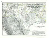
Maybe this could be of some use to someone. I think these were the routes used in the early 1800's I was using it on my research on the Victorio Peak, and the Guadalupe treasure.Have plenty of other old maps mainly of texas old military maps, railroad maps, and Indian maps.
 

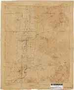
another old map of my collection. I am sure everyone has one but i like to feel important lolpclmaps-topo-az-fort_mcdowell-1904.jpg
 

Just love the balloon; the Dons would be proud indeed.

Considering the methodology and strict order of which the Jesuits operated under, one can be sure there is both a mine and a vault system arranged with precise military strategy in mind. Stealth; Right under your toes and your nose both. Even the trained eye on occasion will fall for a decoy set of markers and so so digs that were constructed to keep you busy there for some while whilst you await bandits or worse. If the monks were there for any amount of time, it had to be for good reason............traps
 

how is the area in and around rough canyon and the area right northeast of millsite canyon and south of iron mountain

Oh yeah if these stones are real and I could be wrong on this next statement. I thought the heart represents a trap of some sort.
 

Arsenic powder and deadfall traps are a possibility,with the manner in which the word "PELIGROZA" has been carved possibly giving some indication of the latter.
But I see no reason to attribute either the maps or the workings to the Jesuits,or for that matter,any other religious order.
There is,after all no documented evidence of any religious group having occupied the Superstitions for the length of time required.
Nor is there any anecdotal evidence from the Apache,or Yavapai,of any such occupation,and surely they would have known.

Regards:SH.
 

The stone maps are real and right on!

jimb:

I happen to agree,although some of the Stones on display may only be reasonably accurate copies of the original set.
But what is it that makes YOU so sure ?
What do they lead to ?
And who do you think were responsible ?

Regards:SH.
 

You would think some scholr somewhere knows what all the symbols mean and would be able to decpher what they mean. I looked on treasure hunter university and they gave an explanation for the symbols, but I guess we will never truely know unless we could go back in time and sit down with the person as they are carving it out. Starting to work on my time machine now and once it is complete I will travel back follow the dutchman to his mine and when i get back we will all go discover it at the same time.
 

Most of them,as used on the Stone Maps,probably mean "this way/that way" or "lookee here".
Like this one....Seen to the left of an old trail...A large rock,rounded at the left end and square cornered at the right,with two vertical (slightly raised) lines and a cross between,also slightly raised from the surrounding surface.

100_0750bigD.png


An older shot of the same boulder....definitely a "this way"

StartMarkBoulderenl.png


Or this...probably a "lookee here"

100_1166sm.png


Regards:SH.
 

Last edited:

Top Member Reactions

Users who are viewing this thread

Back
Top