somehiker
Silver Member
- Joined
- May 1, 2007
- Messages
- 4,365
- Reaction score
- 6,435
- Golden Thread
- 0
- Primary Interest:
- All Treasure Hunting


Since I am not familiar with this area just wanted to know why the shoreline areas and salt river are off limits by homeland security. I have a buddy that is the head firearms instructor for that department, but he didn't tell me anything about it being off limits. He was supposed to come with me but some things came up. thanks again
Only the areas adjacent to the SRP dams and SRP access roads to the dams are restricted.
The river and lakes are still full of boats and pwc's being used for waterskiing,fishing,sightseeing,etc.
Havn't seen any "crazies" out there lately,cause we're all in here I guess.
Open carry is easier,and may act as a visual deterrent if such are encountered.
The biggest dangers are dehydration,heat stroke and injuries from falls.
Cell phone coverage has improved,though still spotty,and I noticed a new tower above Canyon Lake near Tortilla Flat when I was there a couple of weeks ago.
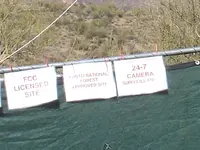
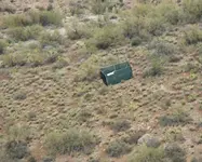
Also found a portable (temporary) receiver/transmitter set up out in the boonies.
It's down low,and only 10 watts,so the range would be limited.But it's registered to a spanish-language radio station in Globe.
Regards:SH.
View attachment 629632
View attachment 629631
 .
.Ellie - did you perhaps move where the photos were located? In other words, if you linked them to here, did you move them so the link no longer works? If not, I can't help you.
CF,
I did as instructed and re-posted photograph. This is such a difficult process to understand. It is hard to determine the correct size as you do not have any control. I cannot place the image on the page where I want it. The images always seem to go to the bottom of the page. Takes the fun out of creativity. Copy and paste was so much easier and now I have a Photbucket account that is also becoming a pain, as I have over 7,000 photographs which 90% of them are backed up on other outside storage data banks. I am now spending twice as much time on TreasureNet as I used to and I am not satisfied with the results and continued maintenance.
Is everyone else experiencing this kind of difficulty or am I the only one? If it is me then I must learn to cope with this newer technology and bite the bullit.
Have a great weekend!
EB
Ellie'
Thanks for your comments. First I believe the author of the map, made it a panoramic view, to include large landmarks. Second, did the author originally place the "head rock" on the small hill? If he did, then again using landmarks from a large area, this is what I found. In the center of this pic, I see the exact rock head on the hill, it is not on that hill but further up the trail, going in.
Hi Scott,
You are correct in your assessment of the Authors use of large monuments as they did indeed use them very frequently. The photograph below is a good example of a large landmark. In this case it is the horse's head as one may notice its similarity to a game piece used in Chess referred to as a Knight. By putting some distance between yourself and your computer screen the horse will become much easier as the distance increases. This Holy Horse can be viewed from Frey Marcos de Niza's Inscription Rock which is 30 miles away. The Horse of the Holy Faith is located on the face of the Superstition Mountains just southeast of the Flat Iron and nortwest of the Broadway Cave. I can tell you from experience that the stone maps were not designed to represent a panoramic view. Most of the items found on these maps are in fact monuments located on the ground within the prescribed depository area (90% of them). The Hearts, the elephant(s), the horses, signs, symbols and other pertinent monuments and clues are placed within this area that instruct you where it is you need to go; Quo Vadis.
The ge pic that you have displayed above looks so much different than what it looks like in real life. As I had mentioned in an earlier post; you really need to see your work in the flesh. Try to find this horse with ge. I can see him with my own eyes while rolling eastbound on US 60 heading towards Idaho Road in Apache Junction in the early to late afternoon. Once people have seen him on the mountain they have never forgotten where he is because he will eventually disapear from view until next year. He comes and goes just like the rest of them... just like the hearts on Heart Mountain or the elephant on Bull Dog Peak or the crescent moon in the Goldfields and many, many others.
There was an earlier thread by Hal Groves called the "Stone Charts of the Superstitions". They should be called what they have always been called for charts refer to water ways that have been mapped. Stone waterways makes no sense when dealing with land maps. Anyway, a group had started talking about the "Twin Buttes" area, South Butte on one side of the Gila River and North Butte on the other. The railroad tracks go through a tunnel, then across a trestle that crosses the Gila. On the right side of the tracks is the "Stone House" that the Florence Quads refer to no mention about the Coke Ovens. hmm! They talked about the hearts, the horse the arrow (7) and so on. The Stone Maps tell us all about this area; "Study/search the hearts, study/search the maps". It seems that no one has bothered to follow the stone maps primary directions. Go figure.
Where in the heck did spell check go to? HELP pages are almost useless. Posting a photograph is not a simple thing to do. Why can't one just copy and paste the easy way as I do not like posting my personnal photographs on "PhotoBucket", have you read their agreement? I am getting old and grumpy too. Can you tell? Ha, Ha!!!
Ellie Baba

