The Peralta Stone Maps, Real Maps to Lost Gold Mines or Cruel Hoax?

Do you think the Peralta stone maps are genuine, or fake?


  • Total voters
    121
anyone in the Arz. area (Cave Creek area) years back met a guy named Buck Stokes (rode with Tom Mix) back in the day. Anyway he was well into his 90's back then. He had a very extensive collection of Arz. history first writings not stepped on by other writers. I never found out what happened to his collection might be something interesting to investagate.? He had a lot of stuff relating to this thread (Who Knows???)
 

anyone in the Arz. area (Cave Creek area) years back met a guy named Buck Stokes (rode with Tom Mix) back in the day. Anyway he was well into his 90's back then. He had a very extensive collection of Arz. history first writings not stepped on by other writers. I never found out what happened to his collection might be something interesting to investagate.? He had a lot of stuff relating to this thread (Who Knows???)

Best thing you could do is do a little geneology research and see if you can find a living family member and get ahold of them. Let us know if you find anything out.
 

Hello twisted fork, good to hear from you.I'd like you to help retreive. The treasure in may.I will give you 3%a for your assistance. I am ex law enforcement so have no fear. My [email protected] call even to talk treasure.

Hey Peralta.....

Very cautious here on the actual digging part in itself. Have always been in it for the hunt rather than into a very real focus on the treasure alone. Could have gone to the Federal pen some years ago over a dig that got out of hand with other property owners coming on the scene and the attention drawn by blasting our way into one of the sealed variations we came into contact with. Word of poisoned cache sites and a number of fatalities associated have kept me some distance away from digging in several marked off caches I have become aware of over the years. Even went back to some of them with a double box detector to verify the presence of the goods and still, even in realizing they are intact, some things are able to out weigh the balance between the "fever" and that good old fashioned common sense. Still the lure is vivid and very much alive.
 

Poisons can be detected and neutralized. It's mostly a matter of chemistry. If a site is poisoned, one should consider the question of who did it, how they did it, and very importantly, how did they intend to access it again later?

As for property owners, if they are adjacent properties then the boundries should be determined to an unarguable extent, and a court judgement aquired in your favor if necessary. If it's on another's property, then bargining skills become important. If it turns out, for whatever reason, that it will not be legal to retrieve your target, and you can't strike a deal, then just move on.
 

Hello twisted fork, I understand, but for sue will keep intouch.
Hello cubanfan, I agree with that quote you mentioned about not being able to get a treasure out of your mind.that's why so many have searched all their lives. If I didn't find fiscal proof that completely confirmed that the treasures were real I would have had to make the decision to quit years ago and it would have been hard. But thank god I kept looking or I would have never located the markings of the peralta stones.
 

Poisons can be detected and neutralized. It's mostly a matter of chemistry. If a site is poisoned, one should consider the question of who did it, how they did it, and very importantly, how did they intend to access it again later?

As for property owners, if they are adjacent properties then the boundaries should be determined to an unarguable extent, and a court judgement acquired in your favor if necessary. If it's on another's property, then bargaining skills become important. If it turns out, for whatever reason, that it will not be legal to retrieve your target, and you can't strike a deal, then just move on.

EE THr, Your right in such methods of approaching such contamination and the high presence of Silver with the Gold (60% Silver+30% Gold+10%Copper..42 pounds to the ton) makes it even more so. It has become my interpretation of such deposits as never having been designed to be opened by anyone under the vow of those days gone by. If they were of Spanish decent and aware of the code, then they would know better; if not then they must be a stinking Frenchy per say, and entitled to the benefits included in the little surprise package with their names on it. Most likely an ore or miner's payroll cache. Any Dore bars systematically hidden near the mine, should be clean (We hope). Their purpose was to file a field claim based on the burning of one ton of the concentrated pay streak and casting the base metals as such. It is possible however that this deposit was turned over every three months as the vein changed; just a thought. If you can find where the guards sat along various incoming or outgoing trails, one just might get lucky there, finding one form of memorabilia or another. I gave up the location of that Dore cache back in 1992 to a couple of kids I met a work because my wife had become a bigger threat than all of the rest put together. I told them of a place to look and they easily scored on two 21 pound Dore bars that had been sitting in the rocks since the year the elders killed the Mexican Miners down on Chicken Creek back in 1857, as they headed for home with their very hard earned ore.

I once found this little eagle (my post photo) 70 feet out straight in front of a concealed mine of 1777. The lower beak section was sticking up out of the center of a patch of white sand, about 4 feet around and the head and body of the three pieces were buried in a little soil mound, 17 feet beyond the beak. The next real mine to consider in a neighboring mt. range, had cache sites set up in the same pattern as mimicked with the eagle on the previous Mt. An eagle means mine numero 1 and according to Ute legend it is and so on and so on. The Spanish hid everything good; count on it being right under your nose.

Very difficult to reach....a high place.....a roost...... If you dig and don't own it, you may find yourself bent over an ugly perspective rather than what you worked so hard and heartfelt to procure; That's the way treasure reveals itself around here.......Don't leave your gun in the truck either; with little more to say otherwise, I really love Utah.
 

Last edited:
Lost Ferguson Gold Mine Link

What a loving and romantic little tale is it not? A little on the "churchy" side maybe?

I heard the story of this adventure clear back in 1972 from a close uncle who bought up a large section of the high desert hillside once owned by Ferguson and know by the locals as his farm (along Wasatch Blvd. at 7200 So.). Bear with this simple example of how hearsay can get out of hand and easily get one killed or worse.

The way I heard it was that Ferguson found the gold alright and when he finally did retrieve a fat sack of it of which he brought back with him, word got out and the Elders threw him in jail and would not let him out until he gave up the location of the mine. So he eventually gives in making them a deal to bring out some gold to them, but as they tried to follow him onto the mountain, he slipped their trail some and got the gold and made it back while they were all still up on the mountain looking for him. That's what I heard and it wasn't many years later that they began core drilling the crap out of the entire mountain and there are hundreds of 3 inch drill holes all over the thing. Imagine the fun one would have in court these days against these same easy going wolves who easily find their way out of the woodwork and into your dreams.
 

Last edited:
Hi! Does anyone know before the damn was built, if the lower parts of the canyouns had water? If they did, wouldn't maps before that be different than todays, more traveled path's, maybe that's why the Peralta maps seem wrong. Also I have turned the maps over and traced the starting mark at goldfield. Does anyone have any input? e-mail me @ [email protected] or post public on here, if you think I,m wrong. Thank

Scott Wellman
 

Lots of ways or angles to view this from, depending on who's hearsay you are tuned to.

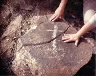
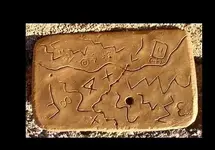
A sensible starting point would be the deposit where the stones were first found. Then head a ways west until you come to the sensible main trail (Apache) and follow it up and around until you intersect with the approximate alignment coinciding with the burial site of the stones. How? go figure....... That's how the heart tablet reads Ok? I would start with the Knife carving side; Bereda...."Big Knife".....A on it... "Cut up and around" (heart inset tablet). Each side says the same thing from a different angle or spin on it. Darned if this same dang curved lined line keeps showing up over and over again coming from all Hippie.jpgdirections; hundreds of miles out. Points out a chain of mines weaving through every old West territory we know of. Same marker sets, same same.RQTreasureCross1.jpgmap-trail011.jpgOn the old Spanish Trail in Braffet Canyon, near Paragonah. 1831. Gift of Charles Kelly. .jpgScan0002.jpg Standing at first dot (Peralta tablet pictured)

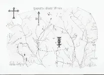
I love this paper map. There is a marked location at each mine site, on every mountain where they hid the real golds veins from us; this map works at all of them. Find that location (simple deduction stratagem); you've found the colors, now where would I get a real good view at it from; a spot that is obvious if there is one there. clue: shaped like a horseshoe....may be faint or maybe you'll see. Two horseshoes, two mines.....this cross picking in stone is the Priest who stands by the river or a dry shape form and marker, used just the same in other areas standing or laying down. Your looking for the other half of the French Curve. Half on the trail, the other half found, reveals the heart and the mine. Circle inside a circle = graduating down in marker size and distance through the range until the last small heart stone marker is found laying on the ground out front. Systamatic compass quads nigh to nigh. First map value at full scale: circles portray a Mt. Peak shaped like a witch hat in Topo graphics. Last and smallest scale of the circles is the human eye, looking at the portal or opening ahead. The heart section of land is a piece of ground right above where the miners hit raw visible gold or silver in the tunnel. Of course the hidden portal will be a stones throw away. Execution of sorts in the process of elimination. Bank shot, 8 ball corner pocket.
 

Last edited:
Hi! Does anyone know before the damn was built, if the lower parts of the canyouns had water? If they did, wouldn't maps before that be different than todays, more traveled path's, maybe that's why the Peralta maps seem wrong. Also I have turned the maps over and traced the starting mark at goldfield. Does anyone have any input? e-mail me @ [email protected] or post public on here, if you think I,m wrong. Thank

Scott Wellman

Scott,

At this time, it seems unlikely that the Stone Maps were actually found as claimed, or where claimed.

Good luck,

Joe
 

The tablets had to be located somewhere between the Old McMillan Mine and 7 mile wash. They would have been positioned along the main trail, heading into the mineral district they portray. Precisely set up as a down scaled under your toes dirt map; a mock up with small marker stones positioned at different points surrounding the tablets, thus a sort of battle aerial in miniature, arranged and placed wherein the ground shapes and a nearby existing mine or dig was used as a bent portrayal; a simple descriptive view of the area and topography surrounding the real mine some miles away. Kind of like a miniature golf course compared to one of full scale in mass acreage.

Most of the know springs in those mountains were either destroyed or reduced to damp spots due to the changes that came with the installation of the dam. Even back in the day, there were just a few puddles in the Superstitions. I suppose that a good number of treasure hunters died along the ancient trail in search of the last water that the old cowboy spring provided, once upon a time. The position of this spring near 4 peaks was and still is a major clue and trail maker leading to the Dutchman. Still not near enough to support the needs of 200 Peralta burrows and a deadly stretch in reaching it to match. Wrong trail cowboy.

Doesn't matter now so, they didn't go that route to begin with. Working one's way North from present day Globe, one encounters numerous decent trails leading into the interior from there. Much easier to defend one's self too. The idea of the goofy hieroglyphic trail and the weaver's needle, was to lead the gringos to their deaths ok? Works pretty good eh? Peralta should not have been lazy having got himself in a hurry and making the stupid move of taking the trail of which most of them were killed on. Caught in his own trap. Contrary to popular belief, burros do not eat and or drink dirt either. 2 or 3 burros would drain a small puddle of water in moments. 200 burros who don't like to eat dirt, would go up the Apache trail anyway. Burros are smart.:coffee2:
 

Last edited:
8)
Scott,

At this time, it seems unlikely that the Stone Maps were actually found as claimed, or where claimed.

Good luck,

Joe

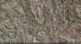
What does this look like to you?
 

Attachments

  • what does this look like to you.kmz
    2 KB · Views: 162
Could be a place of many forgotten dreams, once the bottom of the ocean too.

The same way a fart works in the bathtub; first off, now which way did the silver go when it popped?
 

Maybe this will help.It's a kmz file.
Opens with Google Earth.
It's a rock formation which,from above,looks like a knife.

overview.jpg
 

Last edited:
Wayne,

Lots of interesting shapes in that picture: Hearts, Seven and any number of symbols. Trouble is, we are back to needing an areial picture to see them. That being said, I couldn't pick out a very good "knife". It always helps to have an active imagination. Mine ain't so good no more......:icon_scratch:

Take care,

Joe
 

Last edited:
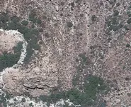
Joe - it's not visible in the image Wayne posted. You have to zoom in to see it - I'll try to zoom in and capture an image and post it here in case anyone wants to see it. It does have the appearane of a dagger, BUT (and it's a big but imho), I woud hazard a guess that I could pick just about anywhere to zoom in on Google Earth in the Superstitions and we could find rock formations that look like things. It just always seems futile to me, but heck, what do I know - I haven't found anything either :).

dagger.png
 

Last edited:
Wayne,

Lots of interesting shapes in that picture: Hearts, Seven and any number of symbols. Trouble is, we are back to needing an areial picture to see them. That being said, I couldn't pick out a very good "knife". It always helps to have an active imagination. Mine ain't so good no more......:icon_scratch:

Take care,

Joe

Unfortunately,I didn't have time last week to make a side trip to the "black rectangle" I posted earlier.I suspect a photo of it would have shown how different such things usually turn out,when a "real" photograph is available.Knowing this,I have never had much faith in G/E treasure hunting as it applies to the Stone Maps.
I can understand why some do get excited over discoveries like "skumpa's knife",given their limited experience in the mountains.I can only suggest they go out and have a look for themselves.They might get lucky.

Regards:Wayne
 

One might look for an "infield triangle" within the boundaries of said blade. A = Apex.......tree and stone together.

Most folks would think you were cracked up if you told them you needed a hot air balloon back in the day; a forked tree stump is the marker they made where one would tie the mooring line off at. I wonder what would happen at sunrise or sunset with the shadow and all that? If you can stand there and picture it, well.
 

Last edited:

Top Member Reactions

Users who are viewing this thread

Latest Discussions

Back
Top