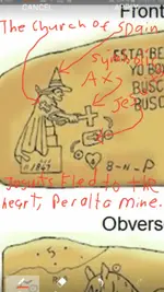
OK here's my questions on the Stone Maps. If they were made back in the 17-1800's by hand tools, how long would it take to make them? Did they carry them in with them and updated them as they went along? Did they make them all at once for a reference for others to use? If they were for others to use, why rock and not paper or leather? Leather would have been faster to make and easier to carry along with them. If they made them as they went, then everyone in the party would have known about them. If they made it that far out of the Supes, why bury them? They would have been far enough out that their safety would have been good enough to make it home. Did one man carry these stones all the way out and then bury them? I am trying to believe that it was possible for them to have been created back then and try from that viewpoint to say how did they get made and why? The area that they were found was not close to water, closest was about 5-7 miles away from Silly Mountain. Granted the water table was higher back then, but all the springs were in or next to the edge of the supes. Again how long would it take someone to make the maps with hand tools back then? Then begs the question of why spend that much time on a map?


