The "Peralta" Stone Maps --- On Their Own

Joe

You can not see all the Stone Map Trail from The top of Supertition Mountain , IMO . You can see only some fragments and of course the hill where end the trail . The trail cross four canyons until it leads to the hill near Someo Montana mine .

Marius,

That's a good opinion, but it's just an opinion until you have been there. From the top of the ridge, you can see a great deal of the trail map. From directly above, you can see it all.

Good luck,

Joe Ribaudo
 

Joe

" My " trail is exactly like in the map and the hills ( lugares ) are exactly in the same location like in the stone map . Exactly and not approximately . 8-)
 

Following the gold to the mother load sounds good. However many areas have fine gold all over the place. Lynx creek, Little San Domingo are good examples. There is no hard fast rule. The mother load has worn away over millions of years depositing gold for hundreds of miles. Looking at the Goldfield deposit I bet the gold is under the Superstition volcano at the Goldfield level. Perhaps some pushed up here and there.
 

Following the gold to the mother load sounds good. However many areas have fine gold all over the place. Lynx creek, Little San Domingo are good examples. There is no hard fast rule. The mother load has worn away over millions of years depositing gold for hundreds of miles. Looking at the Goldfield deposit I bet the gold is under the Superstition volcano at the Goldfield level. Perhaps some pushed up here and there.

Frank,

Many years ago my uncle showed me a map of Arizona that showed mines. There was a belt that came from the northwest and came right up to the Superstitions. At that point it became pretty blank. Southeast of the range it started up again and continued on.

I believe you are correct.

Take care,

Joe
 

Hal there is no probably in my interpretation of the maps. They are very precise and short of including a photo of a clue the carvings are more than adequate to allow anyone to follow the trail. There was an effort to hide the clues within the horse and priest but once you enter the mountains (the horse identifies the specific mountain and the priest tells you where to enter) the trail maps contain no hidden clues. The heart insert is the security key to the maps, you carry the seventy five pounds of stone and I carry the 8 oz heart and you cannot complete the trail to its end until I insert the heart. That's pretty good security don't you agree?

goldbugpr,

Yes, excellent security... unless the key is lost or broken beyond repair. Then the whole thing would be essentially useless. I guess that I am having some difficulty with the theory because I do not have the advantage of reading your work in its entirety. I will once it becomes available... please let us know. Hopefully you have nailed it on the head, but there is so much pointing to a modern work that I am convinced that it was Halseth. It is just a theory, like the others, but it is logical and probable. Reaching out to the remaining family members might provide the curious with some direction.

I do not think that anyone in their right mind would intentionally lug 75 pounds of stone into the Superstitions. A rubbing of the stones on paper would have the same effect and almost no weight.

Can you offer one other example of a map that was designed to be used in the way that you are suggesting?


All,
Oren Arnold has a few things to say about the Superstitions and the pursuit of gold.
Perhaps a thread on the early years of the Don's would be useful.
From a historical perspective.
Several interesting people to think about.
 

Last edited:
Oroblanco,
I sure would like to know what you liked about that last post?
I am going to guess that it was my comment regarding the Don's?
Did you not try to have a conversation about their possible involvement some time back on another forum?
I seem to remember that it was not well received.

Sometimes the answers are so obvious that we are blind to them.
Hope that you are well.
 

... I do not think that anyone in their right mind would intentionally lug 75 pounds of stone into the Superstitions. A rubbing of the stones on paper would have the same effect and almost no weight.

Can you offer one other example of a map that was designed to be used in the way that you are suggesting? ...

Nor would they need to bury the stones in some obscure sand pile in the desert, located within 'enemy territory', IMO. Of course, the 'Peralta Stones' were alleged by some to have come from Mexico. This makes some sense at least, although the practice of engraving secret messages on portable stones seems unnecessary in the modern age.

There are several other alleged 'stone maps' in our treasure lore, but I believe all are engraved on bedrock somewhere in their target vicinities. This makes much more sense, IMO.

Springfield,
"other alleged stone maps?
I am still trying to play catch up. Will you share a few examples?
Thank you!

"Unnecessary in the modern age".
Yes. So, if they are modern, the question becomes why, why, why?
 

Last edited:
Hal

The stone maps may could read only from the author and their relatives which knew where lies the map . I believe how , no to hide the stones tablets in the desert , but to left them in the central square of Phoenix , again nobody could to decrypt the trail map .
The stone tablets are Jesuits maps . The Peraltas antecedents have relation with Jesuits and maybe the last ancestors were Jesuits too . Why are the maps Jesuits? Because a Jesuit map has for marks only land shapes .
 

Last edited:
Springfield,
"other alleged stone maps?
I am still trying to play catch up. Will you share a few examples?
Thank you!

"Unnecessary in the modern age".
Yes. So, if they are modern, the question becomes why, why, why?

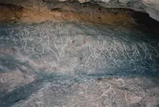
Many petroglyph panels showing apparently 'non-native appearing' carvings have been tagged to local legends all though the Southwest and Mississippi Valley - probably other places too. I'm sure many following this forum are familiar with various examples. I'm very familiar and have written a bit on one of them myself near Santa Rita, NM. The following link is a cool photographic flyby representation of it. I've also provided one of my own old still photos.


[video=vimeo;28532295]http://vimeo.com/28532295[/video]


map cave .jpg

When I say 'modern' in the context of this discussion, I'm referring to Renaissance and later. Yes, why indeed - it's the most important aspect of all this stuff, IMO.
 

Last edited:
Many petroglyph panels showing apparently 'non-native appearing' carvings have been tagged to local legends all though the Southwest and Mississippi Valley - probably other places too. I'm sure many following this forum are familiar with various examples. I'm very familiar and have written a bit on one of them myself near Santa Rita, NM. The following link is a cool photographic flyby representation of it. I've also provided one of my own old still photos.


[video=vimeo;28532295]http://vimeo.com/28532295[/video]


View attachment 870730


When I say 'modern' in the context of this discussion, I'm referring to Renaissance and later. Yes, why indeed - it's the most important aspect of all this stuff, IMO.

Springfield,
Thank you. It seems that you have studied this cave to some extent. Why are the inscriptions considered a map, as opposed to something else... like artistic expression or a graphic narrative?
Do we know what it is a map of?
 

Springfield,
Thank you. It seems that you have studied this cave to some extent. Why are the inscriptions considered a map, as opposed to something else... like artistic expression or a graphic narrative?
Do we know what it is a map of?


I have some strong opinions, but I'd rather not sidetrack this thread. My point was to offer that stone maps are more likely to be permanent, not portable.
 

Springfield,
Point made. What most people do not know is that right here in NJ, we have something similar... as far as stone maps go. This collection is not easy to find, but they are a series of inscribed stones with what looks to be figures and symbols. The figures are actually designed to be part of the represented location. These were done by Native peoples and are absolutely fascinating. The thing about these stone maps is that they are small enough to carry around. Or practical.
 

This is just my opinion.
The "intended reader" is you, me, and anyone else who is beguiled by the cipher.
Think about where they were "found".
Think about the letters D - O - N.
SO, in my mind, it did not matter who discovered the stones.
It was only important that they were found and perhaps where they were "reportedly found".

Discovered in 48/9' and first (published) reported on in 64'?
It took some time (15 years+/-), but they ultimately did find their way into popular culture.
And I believe that this was the goal.

But, in the end, I believe that the cipher was a gift to the DON's.
From a DON.

edit: (I want to be clear regarding the Don's and their involvement. Halseth was an "individualist" and it is my guess that he work independent of the Don's.)

How does one know "how" to read the maps?
Well, it seems that many of the theories regarding the stones use an aerial view solution.
Is it the availability of Google Earth driving these theories or something called intuition?

Odd. Halseth is the name.
This I can say with some confidence.

View attachment 869108


Find an aerial photograph of the area, ideally one from the period.... no easy task.
For Google Earthians, play with the year and time effects... adjusting shadow and light.
I use the oldest color imagery because it has very little vegetation, the photographs being taken in the winter months.

Three of the stones offer a unique "registration" mark.
The marks for me were the hat, the knife, and the horses right ear.
Look for geographic features in your photograph that "match" these marks.
When you find a corresponding "mark", use it to determine scale and positioning.
Repeat for the remaining stones.
Now comes the difficult part.
Using the formula on the trail stone, apply triangulation to the composite map.
If the theory is correct, and if there is something to be discovered other than a lesson in greed...
well, this should get you there if there is a place to get.


Hal---

I appreciate your in-depth reply. While I haven't had a chance to try applying your suggested solution yet, it seems straight-forward enough to enable testing by others (which is more than I can say about many other possibilities which I've seen posted!)

Thanks.
 

Springfield,
Point made. What most people do not know is that right here in NJ, we have something similar... as far as stone maps go. This collection is not easy to find, but they are a series of inscribed stones with what looks to be figures and symbols. The figures are actually designed to be part of the represented location. These were done by Native peoples and are absolutely fascinating. The thing about these stone maps is that they are small enough to carry around. Or practical.

Yes, the native Americans used inscribed rocks in many instances - note the famous Hopi broken tablet in the Southwest. Europeans had other more convenient media for portable documents.
 

Hal

The stone maps may could read only from the author and their relatives which knew where lies the map . I believe how , no to hide the stones tablets in the desert , but to left them in the central square of Phoenix , again nobody could to decrypt the trail map .
The stone tablets are Jesuits maps . The Peraltas antecedents have relation with Jesuits and maybe the last ancestors were Jesuits too . Why are the maps Jesuits? Because a Jesuit map has for marks only land shapes .

markmar,
I am trying to keep up with you, but it is not easy. So, the stones are the orphaned children of Jesuits left by the order in the central square of Phoenix? The Peralta's were connected to the order in some way and a Jesuit map is composed of only "land" shapes?

Is this correct?

Thank you.
 

EE Thr,
It is a simple solution, but when you see the stones in their proper place and scaled correctly, well, that is when the difficult work begins. I was hoping to share my composite map at this years event at the Don's camp. With so many experienced eyes looking at it and an open conversation about "triangulation", perhaps the final instructions will be made obvious. Wouldn't that be amazing. Reaching the answer collectively in the Shadow of the Superstitions?
If I don't make it this year, copies of the composite map are hidden in Tortilla Flat, for anyone interest.
 

Guys,

Lot's of true information, as well as some false, in your posts. If the maps are an aerial view of the topography of the Superstition Mountains, can either of you provide a topographical map showing a highlighted view of the Stone Maps Trail Map?

Everything must be in it's proper place and the entire map must flow, as it does on the stone. Mind you, it does not have to be perfect, but close enough to confirm the authenticity of the map. I still believe I have the only reading of the maps that meets that criteria.

Once again, the end of the Stone Map trail is the Heart. To be exact, this heart:


Here's another:


I have the USGS aerial photos used to make topographic maps from the 60'-70s. The trail, like many old trails in the Superstitions, show up as faint lines. You can see the one that comes out of West Boulder, goes over the saddle separating Little Boulder and West Boulder. It leads directly into the heart above. This is that trail just before you reach the heart:


I don't believe anyone else has ever shown this kind of, in the correct place, evidence that matches the Stone Maps. Here is one of my USGS Photos:


Notice anything familiar??? Do you know where that familiar shape is.....on the ground?

Want to see most of the trail map in person? Hike up to Superstition Peak and take a few pictures down into West Boulder. One person who has taken pictures of the Stone Map Trail, from the north side of the main mountain, while on the trail is,
Greg Davis. I don't know if he knew he was on the trail, but you can see the pictures at Greg's house, which is where I saw them.

Good luck,

Joe
the end of the stone map trail is the heart? really,what is your proof and motive for saying this,what kind of agenda are you trying to put people on now?,you know this isn't the end of the trail,this trail only takes you to the markers to show you which way to proceed ,and over the years these markers have been torn down ,removed,and rebuilt many times over, and even been put in different locations, its not even close to being the end of the trail,and if this is what you think is the end of the trail,were did it start? im back.np:cat:
 

NP,

"the end of the stone map trail is the heart? really,what is your proof and motive for saying this,what kind of agenda are you trying to put people on now?,you know this isn't the end of the trail,this trail only takes you to the markers to show you which way to proceed ,and over the years these markers have been torn down ,removed,and rebuilt many times over, and even been put in different locations, its not even close to being the end of the trail,and if this is what you think is the end of the trail,were did it start? im back.np
cat.gif
"

Well.......I have no agenda, such as trying to lead people away from the Superstition Mountains and into an unrelated area, completely out of the picture, or trying to convince folks of a mission building where none seems to have ever existed.:BangHead:

The Stone Map Trail begins at the bottom of Hieroglyphic Canyon, goes over the ridge and down a ravine into West Boulder Canyon. To most people, it probably seems pretty obvious that the trail ends in the center of the heart. Some, like you, have no idea where it starts or ends.

On the other hand, you could start your trail at Parker Pass, also shown on the Stone Maps. In either case, it ends at the heart. I don't know how many times I have to explain it, but there is always someone who wants to hear it again. In a few weeks or months, you will probably ask the same question again.:BangHead:

Good luck with your Spirit Mountain.......agenda.:)

Joe Ribaudo
 

Top Member Reactions

Users who are viewing this thread

Latest Discussions

Back
Top