The "Peralta" Stone Maps --- On Their Own

I have seen that building ruin somewhere before...
if you notice my avatar, I have spent some time looking for piles of adobe.

Between all your running around Superior,Picket Post,Queen Valley,you probably did see it where every one says its at.
How many times have you been around that area running around in your younger years.
 

Rex have you ever used a map? Can you identify any clues on the map? The skyline here at the superstitions doesn't look anything like that.
Howdy goldbugpr,

You are here X, and we all know your reason for being here, which is of course to sell you book. While there is nothing wrong with that, most of us are tired of all the new books that keep coming out that fall short of a real discovery.

I enjoy looking into everyone's mind, and follow on how they manage to put a theory together on their dicipher of the PSM's. Some even place them outside of the Superstitions, go figure. Don't expect everyone to see things your way. All you have is a theory, no facts, so others opinions are just as good as yours.

Your train of thought does not seem consistent when you use the Gila as your starting point. If this was the correct starting point according to the ariel view, the horse should be just due east from there. Your horse also lacks reason for being a horse, a lot of us can't see what you see.

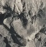
The heart that you found is too small in my honest opinion. The trail leads to the center of the heart in the PSM's, where the trail ends. The heart that you found is too small to travel on, and too small to have anything of value in it.

A small slab of quartz is unworthy of what one would expect to find at the end of the trail. In my opinion, your misconceived theory degrades the meticulous creation of the PSM's.

Respectfully,
Homar P. Olivarez
 

Last edited:
I agree that all theories should be considered but you have to be smart enough to eliminate the ridiculous ones. I don't write books for people on the forum since most already know it all. There are a lot of people that enjoy a complete story and I can provide that. If any one else has a complete theory and can identify all the clues in their proper order and location I would listen.

If you start at the small cross above the El and use the E just above the Cobollo to orient the map to the compass you do not need ariel views or topos to get you started on the trail. Even though you don't see the river in the photo it works on the ground. crossing the river at that well known location where the friendly Indians live, and travel in the NNW direction as indicated,( using the existing roads) you soon pass by the next two clues being circles with dots in them, representing the two small dark peaks that the Az National Guard rifle range is built up against, on a clear day you will be able to see the omega sign out many miles across the desert. If you travel towards omega in a few miles you come to the RIO and the first of five waterholes indicated on the map. as you continue on the trail to the omega at some point you would realize that it is really Dinosaur Mountain which appears as a single big bump coming out of the desert floor. It is very clear from the ground maybe not so clear using technology that was not available to them. I realize that the images on the maps do not exactly replicate the subject but to someone using the maps to travel across mostly uninhabited desert would find the precise. Check it out on GE from Florence near the state penn, fly past the two small peaks and maybe you will see.
padre.jpg small E.jpgThe small end of the cross always points in the direction of travel.
 

Last edited:
I agree that all theories should be considered but you have to be smart enough to eliminate the ridiculous ones. I don't write books for people on the forum since most already know it all. There are a lot of people that enjoy a complete story and I can provide that. If any one else has a complete theory and can identify all the clues in their proper order and location I would listen.

If you start at the small cross above the El and use the E just above the Cobollo to orient the map to the compass you do not need ariel views or topos to get you started on the trail. Even though you don't see the river in the photo it works on the ground. crossing the river at that well known location where the friendly Indians live, and travel in the NNW direction as indicated,( using the existing roads) you soon pass by the next two clues being circles with dots in them, representing the two small dark peaks that the Az National Guard rifle range is built up against, on a clear day you will be able to see the omega sign out many miles across the desert. If you travel towards omega in a few miles you come to the RIO and the first of five waterholes indicated on the map. as you continue on the trail to the omega at some point you would realize that it is really Dinosaur Mountain which appears as a single big bump coming out of the desert floor. It is very clear from the ground maybe not so clear using technology that was not available to them. I realize that the images on the maps do not exactly replicate the subject but to someone using the maps to travel across mostly uninhabited desert would find the precise. Check it out on GE from Florence near the state penn, fly past the two small peaks and maybe you will see.
View attachment 865772 View attachment 865773The small end of the cross always points in the direction of travel.
goldbugpr,

I am sure you will find plenty of readers for your book, and do hope that you make a nice profit. Many innocent readers will be wowed by your presentation, and wonder how you were able to see your horse when they, and no one else can.

Since you have brought your ideas to the table, I still question your train of thought. You state as if though it were a fact, that the small end of the cross always points in the direction of travel. You yourself placed an overlay of the horse stone on the Gila claiming that it matched perfectly. If one were to follow in the direction of that cross, one would be going towards Mesa, not Gold Canyon.

On the trail map, the small end of the cross points elsewhere, and not in the direction of the trail. In my honest opinion, your idea of following in the direction of the small end of the cross has proven to be wrong.

Homar P. Olivarez
 

I agree that all theories should be considered but you have to be smart enough to eliminate the ridiculous ones. I don't write books for people on the forum since most already know it all. There are a lot of people that enjoy a complete story and I can provide that. If any one else has a complete theory and can identify all the clues in their proper order and location I would listen.

If you start at the small cross above the El and use the E just above the Cobollo to orient the map to the compass you do not need ariel views or topos to get you started on the trail. Even though you don't see the river in the photo it works on the ground. crossing the river at that well known location where the friendly Indians live, and travel in the NNW direction as indicated,( using the existing roads) you soon pass by the next two clues being circles with dots in them, representing the two small dark peaks that the Az National Guard rifle range is built up against, on a clear day you will be able to see the omega sign out many miles across the desert. If you travel towards omega in a few miles you come to the RIO and the first of five waterholes indicated on the map. as you continue on the trail to the omega at some point you would realize that it is really Dinosaur Mountain which appears as a single big bump coming out of the desert floor. It is very clear from the ground maybe not so clear using technology that was not available to them. I realize that the images on the maps do not exactly replicate the subject but to someone using the maps to travel across mostly uninhabited desert would find the precise. Check it out on GE from Florence near the state penn, fly past the two small peaks and maybe you will see.
View attachment 865772 View attachment 865773The small end of the cross always points in the direction of travel.
Goldbugpr

Yes I can provide a complete theory to the Stone Maps and photo's to any book you want to write about them, All for the low price of free! Except my name shall be placed in the credits.
If you can live with that I'd surely cut a deal with you and take you to all the places on the maps.

If interested give me a jingle: [email protected]

Rex
 

Goldbugpr

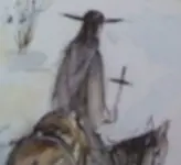
At the end of the stone trail is the Latin heart . But accidentaly is not a single heart , are two , the one on the other , and both have " broken ' the up right side . The priest on the top , shows the location of the cave . The hill in the middle , is the circle drawing of the end point in the stone trail .
Tell us , where is your priest ? What are the symbols in the stone trail map ?

Hearts and priest.jpg
 

There is no actual priest, it just contains clues. The lines on the robe represent the appearance of the cliffs above the Don's camp when seen from the trail about half way in.Dacite Striations.jpg Just past the cutoff to Quarter Circle U. Just a clue to keep you going in the right direction. More if you want it.
 

Last edited:
The small end of the cross indicates direction of travel. As with every other clue on the maps, every time it is used it means the same thing. With the priests hat being the north marker on this map, the big cross indicates that the direction of travel is Easterly.
As you make your up towards what is now called Peralta Canyon, such a big canyon that it had to be shown on the map, also had to be marked as a direction of travel not to take, go East. The DO NOT Take sign are the small lines on either side of the cross on the shoulder of the priest.Shoulder cross.jpg
As you continue East, the trail resembles the hemline of the robe.
That trail is called Dutchman's trail, Number 104 in Jack and Elizabeth's Hikers Guide to the Superstition Wilderness.
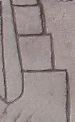
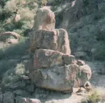
After an hour or so on the trail its time for the next clue and when you are at the correct spot on the trail that clue appears.Cubes.jpg Here is what they look like from the trail.Stack crop.jpg
 

There is no actual priest, it just contains clues. The lines on the robe represent the appearance of the cliffs above the Don's camp when seen from the trail about half way in.View attachment 866457 Just past the cutoff to Quarter Circle U. Just a clue to keep you going in the right direction. More if you want it.

Goldbugpr

I believe Kenworthy all ready did this theory and come up short or found, one hell of a payday, Depends on what story you believe, I'll believe, came up short. Your theory seams to be way to complicated for any one to find there way back once they left for awhile or sent someone else to recover what they left behind.

Rexmick
 

Howdy goldbugpr,

Since your theory does not seem to be open for debate, as you make your own rules as you go along, I am bowing out. I did not question your train of thought out of my own interest, but for the benefit of the many who frequent these forums.

Your inability to provide an adequate response to my observations, or to present a justifiable reason for your interpretation of any of the symbols, leaves me no choice but to consider your theory eliminated.

Respectfully,
Homar P. Olivarez
 

The small end of the cross indicates direction of travel. As with every other clue on the maps, every time it is used it means the same thing. With the priests hat being the north marker on this map, the big cross indicates that the direction of travel is Easterly.
As you make your up towards what is now called Peralta Canyon, such a big canyon that it had to be shown on the map, also had to be marked as a direction of travel not to take, go East. The DO NOT Take sign are the small lines on either side of the cross on the shoulder of the priest.View attachment 866520
As you continue East, the trail resembles the hemline of the robe.
That trail is called Dutchman's trail, Number 104 in Jack and Elizabeth's Hikers Guide to the Superstition Wilderness.
After an hour or so on the trail its time for the next clue and when you are at the correct spot on the trail that clue appears.View attachment 866533 Here is what they look like from the trail.View attachment 866534

goldbugpr,
I am reading your posts this morning (which I find fascinating) and am hoping that you will help explain one critical observation that seems to trip-up most theories. If the artist did use very specific geological features in the environment as their source of inspiration, why then is the graphic representation not identical to the original object. Your stepped rock does look similar, but it is in no way "identical". The "river" lines also. In my mind, this is an enormous problem.. not just for you, but for most theorist. The maps can not be stretched, distorted, or "made-to-fit". A cardinal rule... which seems logical enough.
OK, I hope that you are well and wish you the best of luck with the book.

One last thing... could you explain the symbolism of the three steps. What do you believe them to represent.... if anything other than the rock pile pictured above.
Thank You!
 

Last edited:
For anyone,
Have you ever wondered why there are four maps (+one or two inserts depending on what you believe)? Here is what I have learned form placing the stones as I have done (shown in previous posts). Once one positions the individual maps correctly, (superimposed onto an aerial map of the period [circa:1940's]) one must use triangulation (between all the maps) to resolve the final location. It will not happen until one has all the maps scaled & correctly placed. Kenworthy has demonstrated this understanding of triangulation in a video lecture that cactusjumper lent me and while his attempt was clumsy and not correctly placed, he did understand the final steps in unlocking the cypher. The symbols are obvious "treasure" symbols... it is how they were used by the individual artist which is the real bugger.
 

Hal, you must keep in mind that the maps are carved in stone not painted on canvass. The images although not exact are very accurate and like you said sorta looks like it. When taken in context of indistinguishable desert they are easy to see and follow.
 

Top Member Reactions

Users who are viewing this thread

Back
Top