The "Peralta" Stone Maps --- On Their Own

Had to go to the Apache Junction fruit market today so I decided to meet up with Tom K at the Blue Bird. By the way they have a set of the stones on display in the front window. Copies just like the museum. God everyone has them. Tom told me a acquaintance made the stones in the 30's and placed them in the FJ spot. I asked why there and he said the guy was working in the area. This person also worked as a tombstone engraver. Which explains a lot. I wanted to ask him about the Burns from Burns Ranch and the pitt mine. The stones came up after I noticed the window display. I will still keep a open mind as its fun to play with the issue.

Frank,

Tom told me this story some time ago. Not much chance he will ever divulge the name. I believe it to be true.

Take care,

Joe
 

Frank,

Tom told me this story some time ago. Not much chance he will ever divulge the name. I believe it to be true.

Take care,

Joe


Say it isn't so " JOE " :flag_red: RED FLAGGED

You new it was a hoax, and then fed the hoax, with your topo map you offered to everyone,
to go see the end of the trail. thats low, JOE! Tom K. is full of (undivulge imformation) I,d say something else! And Joe you believed all that without a document to prove it! Are you trying to pass yourself off as a swell guy. Are you trying to muscle your way in to the circle. (JERK):laughing7:


Wrmickel1
 

And I have no doubt he believes that his acquaintance did make the stones in the thirties.
Tom would have no reason to lie, or to think this person would tell him something which wasn't true.
Which is why I asked the questions I did. I didn't really expect there would have been an answer given by Tom.
Even if Frank had asked.
Tom has always been consistent in his declarations that all of the Stone Maps are fake....even in conversation with friends.
Might be a good reference to fall back on, should the need arise.

Regards:Wayne

Somehiker

Take my advice' send the sarg out to the arch and look north holding the trail map insert, if its not a exact match have him tell everyone on the form I,m full of ( **** )

Now that owning up to one's word.

Butt ON THE LINE Wrmickel1
 

Stgfda

The path with the 1 is the easyer to travel, Once your on top of the big point, look down the ridgeline you we see a black rock shaped like horse, and 50 feet from that is the mine, goes back 120 ft on a curve, then branches in two directions, at the branch is a big crack in the cieling, about to cave-in from water from the pit mine above, up on the saddle' Be Careful

Stay safe wrmickel1
 

Somehiker

Take my advice' send the sarg out to the arch and look north holding the trail map insert, if its not a exact match have him tell everyone on the form I,m full of ( **** )

Now that owning up to one's word.

Butt ON THE LINE Wrmickel1

Sorry Mick, but the sarge goes where he wants to....whenever nature calls.
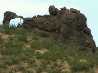
There is a different and smaller arch for him to look at. might even be a bell on the ground below.
Kinda looks that way in one of my blurry pictures,but both could be natural of course.
Just because the Latin Heart says so, doesn't make it true. An acquaintance of mine told me the Latin Heart was destroyed, and another says it never existed to be destroyed.When it comes down to the this, that, or the other, I'm gonna go with the other.
But Garden Valley is a great place to wander through and around. That long ridge to the S/E, Black Mesa, gives much to wonder about for those with a keen eye.
So keep chipping away at it.

Regards:SH.
 

Last edited:
Sorry Mick, but the sarge goes where he wants to....whenever nature calls.
There is a different and smaller arch for him to look at. might even be a bell on the ground below.
Kinda looks that way in one of my blurry pictures,but both could be natural of course.
Just because the Latin Heart says so, doesn't make it true. An acquaintance of mine told me the Latin Heart was destroyed, and another says it never existed to be destroyed.When it comes down to the this, that, or the other, I'm gonna go with the other.
But Garden Valley is a great place to wander through and around. That long ridge to the S/E, Black Mesa, gives much to wonder about for those with a keen eye.
So keep chipping away at it.

Regards:SH.

Black Mesa is not part of the game
Travel my road, the road to fame
You keep chipping away, Nice and slow
Someday, you'll sound just like Joe! :tongue3: :laughing7:

Wrmickel1
 

It is not a big deal for me. I enjoy a hike with Wayne. If he needs a spot checked with my equipment I'm there for him. In a area with a rich history you never know what you may run into. Maps or no maps. It's just funny how many lined up a different site with the same maps.
 

Sorry Mick, but the sarge goes where he wants to....whenever nature calls.
There is a different and smaller arch for him to look at. might even be a bell on the ground below.
Kinda looks that way in one of my blurry pictures,but both could be natural of course.
Just because the Latin Heart says so, doesn't make it true. An acquaintance of mine told me the Latin Heart was destroyed, and another says it never existed to be destroyed.When it comes down to the this, that, or the other, I'm gonna go with the other.
But Garden Valley is a great place to wander through and around. That long ridge to the S/E, Black Mesa, gives much to wonder about for those with a keen eye.
So keep chipping away at it.

Regards:SH.


arch 2.jpg


Is It This One


Wrmickel1
 

It is not a big deal for me. I enjoy a hike with Wayne. If he needs a spot checked with my equipment I'm there for him. In a area with a rich history you never know what you may run into. Maps or no maps. It's just funny how many lined up a different site with the same maps.


Somehiker

There you go! He would love to hike with Wayne, (Wait a min-nuts) My name is Wayne, witch one is he talking about. I'm American and your, dare I say it, Canadian. Well whatever!

Your path is set! ta ta now, To The Arch you will go!

Be Safe on your 15 min, hike.

Wrmickel1

PS if you see don's mule snare it and call me right away, I'd love to get my hands on that ass!
 

Last edited:
"Is It This One"
Nope, it don't look that natural . And it's sort of sitting on top of a big rock, like it was made to be there.
Fifteen minutes is a P-break, not a hike. And this place takes more out of you and me to get to, than any stroll to Garden Valley.
But if you like rock and boulder climbing, there is a shortcut. Gets me there before the sun hits it's zenith.
Haven't seen any mules, but did find a couple of pieces of worn out burro shoes out there.
One half in the "parking lot", and it's matching half on the trail.

Regards:SH.
 

Cubfan64,
Chew it up if you don't mind. I would like to read your take on the results and the approach. Honestly, I think that it is a shot right between the ears, but you might see something that is problematic with the material.

Hal, would you by chance be comfortable posting or forwarding a copy of the spreadsheet with results? I would love to see that.

I'm a chemist, not a geologist, so I can only really approach this stuff from one perspective. There are a few things that confuse me a little bit:

1) The term anomalous is used in many places in the e-mail - I generally use the term to mean something like "unexpected." I can't tell if the e-mail author is using it the to mean the same thing in all cases.

2) I'm not clear as to why the author differentiates between Au, Sn and W (for example) not being mobile while elements like Ag, Cu and Pb are? Again this might be a geology thing I'm missing, but it seems to me that all of those elements could be "mobile" when exposed to weathering. It can't be a density thing because Pb and Ag are more dense than Sn. Could it be because the other elements he listed that he considers "mobile" exist as decomposed ions in stream water, whereas Au, Sn and W are not? Just not sure.

3) I'm also not completely clear as to how the pie plots are being made - I think I get it, but if I see the spreadsheet, I think it will make more sense.

I will say two things though regarding the data:

1) As a general rule, when it comes to any sort of analysis of materials, the first and foremost step is ALWAYS sampling - if you don't get good, representative samples, no matter how good your analysis and interpretation is, you have the chance of drawing incorrect conclusions. Without having been there when samples were collected and just going by the e-mail, I would say they did a better than average job of planning and executing the sampling. A geologist might disagree, but I think it looks reasonable.

2) The way they treated the samples and analyzed them looks very reasonable to me. It would probably have been better to pulverize the samples rather than just screening them to a certain size, however the plan seemed to be looking for evidence of metal elements in the highly weathered portions, so again what they did seems reasonable.

Pretty cool - wish I lived out there and had access to all the instrumentation I have where I work now - I could go on a sampling spree and map the whole mountains for elements. Now THAT sounds like it would be a TON of fun!!
 

And I have no doubt he believes that his acquaintance did make the stones in the thirties.
Tom would have no reason to lie, or to think this person would tell him something which wasn't true.
Which is why I asked the questions I did. I didn't really expect there would have been an answer given by Tom.
Even if Frank had asked.
Tom has always been consistent in his declarations that all of the Stone Maps are fake....even in conversation with friends.
Might be a good reference to fall back on, should the need arise.

Regards:Wayne

Hello

First let me say, that I have MAJOR respect for Tom. We are even friends on Facebook. But No matter what he says in articles, it's my opinion that Tom still believes in the Lost Dutchman and still believes it can be found. So anyone that thinks he is going to give his "real" opinion, isn't being honest with themselves. No one who is actively looking gives up all of their clues..... No one. Not even the guys that claim that they have "put it all out there"....

Thanks
Travis
 

Travis:
None of us can read Tom's mind.
But the topics to which he often responds, and the questions which he himself asks, can give a glimpse into what he may really think.
I have noticed, during the Rendezvous, how some topics draw more attention from him than others.

Regards:Wayne
 

Hal, would you by chance be comfortable posting or forwarding a copy of the spreadsheet with results? I would love to see that.

I'm a chemist, not a geologist, so I can only really approach this stuff from one perspective. There are a few things that confuse me a little bit:

1) The term anomalous is used in many places in the e-mail - I generally use the term to mean something like "unexpected." I can't tell if the e-mail author is using it the to mean the same thing in all cases.

2) I'm not clear as to why the author differentiates between Au, Sn and W (for example) not being mobile while elements like Ag, Cu and Pb are? Again this might be a geology thing I'm missing, but it seems to me that all of those elements could be "mobile" when exposed to weathering. It can't be a density thing because Pb and Ag are more dense than Sn. Could it be because the other elements he listed that he considers "mobile" exist as decomposed ions in stream water, whereas Au, Sn and W are not? Just not sure.

3) I'm also not completely clear as to how the pie plots are being made - I think I get it, but if I see the spreadsheet, I think it will make more sense.

I will say two things though regarding the data:

1) As a general rule, when it comes to any sort of analysis of materials, the first and foremost step is ALWAYS sampling - if you don't get good, representative samples, no matter how good your analysis and interpretation is, you have the chance of drawing incorrect conclusions. Without having been there when samples were collected and just going by the e-mail, I would say they did a better than average job of planning and executing the sampling. A geologist might disagree, but I think it looks reasonable.

2) The way they treated the samples and analyzed them looks very reasonable to me. It would probably have been better to pulverize the samples rather than just screening them to a certain size, however the plan seemed to be looking for evidence of metal elements in the highly weathered portions, so again what they did seems reasonable.

Pretty cool - wish I lived out there and had access to all the instrumentation I have where I work now - I could go on a sampling spree and map the whole mountains for elements. Now THAT sounds like it would be a TON of fun!!

No problem. I will email what I have tonight including the name of the firm that completed the work. You should know of them as they are among the best in the world at what they do. The results are surprising anyway and your thoughts on them are appreciated.

I am thinking about driving out in a week or two to have one more look at things on the horse map before the heat becomes unbearable.
 

Top Member Reactions

Users who are viewing this thread

Back
Top