The "Peralta" Stone Maps --- On Their Own

I was camped over on burro creek...there is a hot spring there... a drill hole that seeps hot water...there is a copper mine there also...on the other side of the hill...
now I doont' know if these things were burros...or donkeys or what...brown, not horse...
having lived in lehi back in the day, I know that these type of critters get a bit noisy if you show light after dark...down right nasty...heeeeeeehawwwww til ya shut the light off...some of them get pissie over a candle...
anyway...some hippies in a Volkswagen bus pull in just before dark...turn around in my camp, and go to the other side of the arroyo....
what I smell bad? I took a bath...all day...
anyway...they proceed to light every type of light known to mankind...fire, stove, dome lights, running lamps...candles...
so long about 10 pm...her come the damn burros...surrounded the hippies an began hawin....there were around fifteen or twenty of them an they set up a racket...
damn, its dark..i wanna sleep....
so after a long damn time...the hippies who just couldn't even say hello as they turned around in my camp...are screaming an throwing stuff at these critters...
I hear things tumbling down into the arroyo...
it would be funny if I didn't want to sleep...it was funny, that is why I let it go on so long...
so finally...I scream across the arroyo..."TURN OF THE {expletive deleted} LIGHTS. STUPID HIPPIES."
well...that went over pretty good...
they scream an argue some more...then finally...they shut the lights off...
the burros get quiet an wander off to do what ever those things do in the dark...

just a story...
 

Hal, and the Canadian buzzard!

If your content on that area, you best be useing the stone cross maps, there the only one,s that pretane to that area.
Cause I,m most certain they were found just like he said they were, I'll bet cha both a trip to don,s pad for bitter taste of sock coffee and a sweet taste of that donkey he braggs about. (I think I,m in love) That he found them like he said.
Everyone changes paths in there lives what happened later in his, has no factor on the stone crosses.

Wrmickel1

I have no issues with the man who discovered the stone crosses and I think that guilty or not, the man has served his punishment. Everyone who stumbles in life deserves a second chance, which is what makes this country so great. I only wish that someone would post a clear picture of both crosses, and both sides. I have never seen one that is clear enough to work with.

The symbols that can be found at the entrance to Peter's.... if you believe that they are real, and not just some illusion, then a wider, more careful look at the area might be smart. Here is one that appears next to one of the "dots" on the corresponding stone. There are more.


Sigh, what a sacraligeous buncha unwashed desert rats. Ya gotta eat me first before I let ya eat my lovely, faithful mule with the sexy, softly rounded tummy. And as for those beautiful, long, velvety, expressive ears, no 'human' could possibly think of food.

Tell me honestly, after gazing into those huge, beautiful, sexy, expressive eyes, could you actually make machaca / jerkey out of the lonely prospectors best friend???

Fiends.

Don Jose de La Mancha
 

somehiker,
Yes, I am familiar with the area. While we disagree with the dating of the stone maps cipher, I believe that you are dead on concerning what took place there. In fact, my last five hikes into the Superstitions all began there, as they naturally should.

What are your thoughts on the symbolism of the horse inscription?

I might have a little something to add to your already extensive file, but in order to appreciate it, you would have to put aside your beliefs on the placement of the stones... if only long enough to give it consideration. That is a tall order for someone like you who is obviously passionate about your ideas.

All journeys have their beginning.
Even spiritual ones.

Ever heard of the "Mormon Map" Hal ?
I've never gone out to see it, but I've got a pretty good idea where it is. If it hasn't been destroyed by now.
I'm not really interested in it, being sure it's modern...ie: post dating to both the stones and Waltz.
I haven't the time to go through my notes right now, but I'll PM the co-ords over the weekend some time.

It's too bad Tortilla Flat and Mormon Flat have been torn up so much and paved over, with most of M/F under the waters of Canyon Lake as well.
I have zig-zagged my way from T/F to the Marina without finding anything but tons of old scrap metal and tin cans. If there were arrastres near the creek in that stretch, I'm sure they were washed away long ago. But there's still lots to see if you hike any of the trails that begin at T/F. It's a bit difficult to find the beginning of some of them, and some are hard to follow even when you do get your bearings, but once you are on them you are walking in the footsteps of many of the original Dutch Hunters.

I don't consider very many of the things which are carved, chipped , or scratched into the stones to be symbolic. At least not more so than any "picture map" such as this one of Washington, DC happens to be...USA Sightseeing Tours of Top US Travel Destinations - Old Town Trolley Tours® - Our Tours...
In other words, if you were to be dropped in the middle of DC during the day with nothing but this map in hand (no compass or other aids), how difficult would it be to find your way around...or even to a specific location such as "Ben and Jerry's". That's how the stones work for me.

That things like the Heart, the Horse, and the Priest had a special meaning for the individuals who made the maps seems evident in the way our attention is drawn to each by the written inscriptions on the stones. The use of the word "YO" on both faces of the H/P Stone emphasizes that the Horse and the Priest was meant to be synonymous, and the "Mapa" and "Coazon" on the Priest side emphasizes the connection with the Map Stones IMO. In that sense, the Horse is definitely symbolic.

Regards:SH.
 

Last edited:
I have no issues with the man who discovered the stone crosses and I think that guilty or not, the man has served his punishment. Everyone who stumbles in life deserves a second chance, which is what makes this country so great. I only wish that someone would post a clear picture of both crosses, and both sides. I have never seen one that is clear enough to work with.

The symbols that can be found at the entrance to Peter's.... if you believe that they are real, and not just some illusion, then a wider, more careful look at the area might be smart. Here is one that appears next to one of the "dots" on the corresponding stone. There are more.


Hal:

This Oct. 2012 shot is of the left side of the bottom end of Peters Canyon.

View attachment 100_1246sm.bmp

Fairly easy to see where Tom K's "monumented trail" goes up and over.
Feel free to re-post it with the 'symbols" circled.

This one is of what some have identified as the "trick in the trail" clue to the LDM.

View attachment 100_1247sm.bmp

And this is the closest view I've ever seen which looks like the "symbol" in the center of the Map Cross.
Even better I think, when seen from the "circle in circle" point up on Tom's trail.

View attachment 100_1255sm.bmp

Regards:SH.
 

Attachments

  • 100_1243cr.png
    100_1243cr.png
    1.7 MB · Views: 109
Last edited:
Ever heard of the "Mormon Map" Hal ?
I've never gone out to see it, but I've got a pretty good idea where it is. If it hasn't been destroyed by now.
I'm not really interested in it, being sure it's modern...ie: post dating to both the stones and Waltz.
I haven't the time to go through my notes right now, but I'll PM the co-ords over the weekend some time.

It's too bad Tortilla Flat and Mormon Flat have been torn up so much and paved over, with most of M/F under the waters of Canyon Lake as well.
I have zig-zagged my way from T/F to the Marina without finding anything but tons of old scrap metal and tin cans. If there were arrastres near the creek in that stretch, I'm sure they were washed away long ago. But there's still lots to see if you hike any of the trails that begin at T/F. It's a bit difficult to find the beginning of some of them, and some are hard to follow even when you do get your bearings, but once you are on them you are walking in the footsteps of many of the original Dutch Hunters.

I don't consider very many of the things which are carved, chipped , or scratched into the stones to be symbolic. At least not more so than any "picture map" such as this one of Washington, DC happens to be...USA Sightseeing Tours of Top US Travel Destinations - Old Town Trolley Tours® - Our Tours...
In other words, if you were to be dropped in the middle of DC during the day with nothing but this maps in hand (no compass or other aids), how difficult would it be to find your way around...or even to a specific location such as "Ben and Jerry's". That's how the stones work for me.

That things like the Heart, the Horse, and the Priest had a special meaning for the individuals who made the maps seems evident in the way our attention is drawn to each by the written inscriptions on the stones. The use of the word "YO" on both faces of the H/P Stone emphasizes that the Horse and the Priest was meant to be synonymous, and the "Mapa" and "Coazon" on the Priest side emphasizes the connection with the Map Stones IMO. In that sense, the Horse is definitely symbolic.

Regards:SH.

Somehiker

Couldn't agree more with you on that. Its what the carver saw as he sat and and carved the stones, There's no scale to the maps as hal suggests' Just a reasonable way to go back and retrieve what they left.

Wrmickel1
 

Sigh, what a sacraligeous buncha unwashed desert rats. Ya gotta eat me first before I let ya eat my lovely, faithful mule with the sexy, softly rounded tummy. And as for those beautiful, long, velvety, expressive ears, no 'human' could possibly think of food.

Tell me honestly, after gazing into those huge, beautiful, sexy, expressive eyes, could you actually make machaca / jerkey out of the lonely prospectors best friend???

Fiends.

Don Jose de La Mancha

That's why we don't make jerky with eyes.
How much could you make outta this roadrunner....biggest one I ever seen.

View attachment big roadrunner.bmp
 

Sigh, what a sacraligeous buncha unwashed desert rats. Ya gotta eat me first before I let ya eat my lovely, faithful mule with the sexy, softly rounded tummy. And as for those beautiful, long, velvety, expressive ears, no 'human' could possibly think of food.

Tell me honestly, after gazing into those huge, beautiful, sexy, expressive eyes, could you actually make machaca / jerkey out of the lonely prospectors best friend???

Fiends.

Don Jose de La Mancha

Honestly Don

You better keep your eye's on the barn tonite ( Cause DADDY"S GOT A SWEET TOOTH TONIGHT ) She might just get donkey napped.

Wrmickel1
 

Ever heard of the "Mormon Map" Hal ?
I've never gone out to see it, but I've got a pretty good idea where it is. If it hasn't been destroyed by now.
I'm not really interested in it, being sure it's modern...ie: post dating to both the stones and Waltz.
I haven't the time to go through my notes right now, but I'll PM the co-ords over the weekend some time.

It's too bad Tortilla Flat and Mormon Flat have been torn up so much and paved over, with most of M/F under the waters of Canyon Lake as well.
I have zig-zagged my way from T/F to the Marina without finding anything but tons of old scrap metal and tin cans. If there were arrastres near the creek in that stretch, I'm sure they were washed away long ago. But there's still lots to see if you hike any of the trails that begin at T/F. It's a bit difficult to find the beginning of some of them, and some are hard to follow even when you do get your bearings, but once you are on them you are walking in the footsteps of many of the original Dutch Hunters.

I don't consider very many of the things which are carved, chipped , or scratched into the stones to be symbolic. At least not more so than any "picture map" such as this one of Washington, DC happens to be...USA Sightseeing Tours of Top US Travel Destinations - Old Town Trolley Tours® - Our Tours...
In other words, if you were to be dropped in the middle of DC during the day with nothing but this map in hand (no compass or other aids), how difficult would it be to find your way around...or even to a specific location such as "Ben and Jerry's". That's how the stones work for me.

That things like the Heart, the Horse, and the Priest had a special meaning for the individuals who made the maps seems evident in the way our attention is drawn to each by the written inscriptions on the stones. The use of the word "YO" on both faces of the H/P Stone emphasizes that the Horse and the Priest was meant to be synonymous, and the "Mapa" and "Coazon" on the Priest side emphasizes the connection with the Map Stones IMO. In that sense, the Horse is definitely symbolic.

Regards:SH.

I will have a look in the fall using your co-ords. Thank you.

I am beginning to understand your approach. It is very interesting and the place where our respective theories go in opposite directions. For me the stones are an exercise in the system of Spanish Treasure Symbols. With that said, most of what we see are examples found in print. The Horse as you must know represents a journey (again either physical, spiritual or both). When you place the Horse Stone correctly, it becomes obvious that the horse is facing west. To confirm this, note the symbol for "east" located at the back end of the horse "E". An "E" in the system always points east (the open end). So, with the horse facing west, one would assume that that is the direction in which to follow... west. But that would be a mistake. Look at the inscription RIO on the stone. The horse is looking in the direction of RIO.. or west.

Look at the word RIO again. It is placed between two curvy lines... correct? That space between the lines represents water, not actual water, but symbolic water. Water reflects as a mirror would. An inverse Image. So, stop and turn around because East is the true direction to travel.

And on the ground, this makes perfect sense. In fact, when placed as I have done, the information on the Horse Stone points directly to the entrance to PC. The journey begins in the TF area... IMO.

Two views of the same area taken this spring. That pool has always been very good to me and my tired feet.


Last edited:
Sheesh, hiker, Wm yer inhuman, insensitive remanents from the past. Proof? look at el foot looses' road runner. I ate the last one in La Barranca del Rio Verde while on search for the lost Gloria Pan mine in southern Chihuahua, kinda tough, but not too bad.

Hal as you and I have mentioned before, always check for reversed, mirror images, some of which may be upside down. Sometimes the entire map is made in such a manner, then others are only so in the final stages. I have seen one that was completly direct and simple, yet no one knowingly ever found the point of interest.

Don Jose de La Mancha
 

Last edited:
Hal

Take the Cross maps pictures

View attachment 801435 View attachment 801436

Marius

markmar,
Yes, that is a poor image of one stone. What I don't understand is why no quality image exists of both and both sides. We have so many images of the stone maps, some which are actually beautiful. I have not spent mouch time studing the crosses, but that would change if someone would share a few decent images. Do you know where they are right now? The crosses I mean. I would appreciate learning the story of what happen to them from the time of their discovery until now. Where are they? and who has them?

Hal, markmar,

The stone crosses, latin heart are gone, completely destroyed. No (good) original photos of them are in the public access. Good photos of the stone crosses do exist but are in the private hands of Mike Bilbry. Good reproductions (plaster) of the stone crosses do exist and there are good photos of them. Some years back, Steve Creager and I were in the mountains and one of the places Steve wanted to see was the site where Mike Bilbry found the crosses, artifacts, and had his mining claims. At that time, there were still a few corner monument markers on the Bilbry claims and you could see where Mike had trenched across a couple places and where he found the crosses. The markers are gone today but you can still see the remains of those trenches.

To locate Bilbry's claims, from the Tortilla Ranch trailhead take the Peters trail to the high saddle overlooking Peters canyon below. Once you reach the bottom and are in Peters Canyon, immediately look to your right up a sloping area with some cliffs just to the north of it. Head for that sloping area and you will find the claims and trenches from the debris piles. I have a good photo of the area I took when Steve and I were there but the system won't allow me to post photos.

Mike Bilbry told me the story of how he discovered his claims and the crosses and other artifacts. He is still living in Arizona and doing well.

I don't know much about DMSO other than it is highly effective. Mike said he knows he made a mistake and paid his debt to society and has moved on.

Matthew K. Roberts
 

Hal,

Some comments about the Stone Crosses can be found here:

Lost Dutchman Gold Mine - Arizona Superstition Mountain Wilderness - Gold Mining ? View topic - Travis Tumlinson and the Stone Maps

In my opinion, any posts by Kraig Roberts should be viewed with caution. If there is anything he posts that you feel worthwhile, you should copy it somewhere, as he has a tendency to delete them.......all of them.:dontknow:

For the true history of Bilbrey and his crosses, I would suggest asking Tom Kollenborn. I imagine he will be at this year's Rendezvous.

Take care,

Joe Ribaudo
 

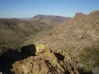
Bilbry claim location.jpg

Bilbry's mining claim and Stone cross, artifact location.

This photo was taken from the saddle on the Peters Trail overlooking Peters canyon below.
Peters canyon can be seen on the left half of the photo.
To the right of the photo, about half way up is an open sloping area with cliffs to it's north.
That open area, up against the cliffs, is where Mike's claims were and the trenches where he found the artifacts.
Best access is to go down into Peters Canyon and go up the canyon to the right and the sloping area.
Look for the debris piles and you will find the trenches.

Matthew K. Roberts
 

Hal,

This is what Tom Kollenborn wrote about the stone cross maps:

"These are the stone cross maps allegedly found on the northwest side of Tortilla Mountain by Michael Bilfry and Ed Farr around 1977. They were considered a fraud from the beginning, but there are always those who believe in lost gold and would accept these crosses as authentic."

Good luck,

Joe
 

Hal, markmar,

The stone crosses, latin heart are gone, completely destroyed. No (good) original photos of them are in the public access. Good photos of the stone crosses do exist but are in the private hands of Mike Bilbry. Good reproductions (plaster) of the stone crosses do exist and there are good photos of them. Some years back, Steve Creager and I were in the mountains and one of the places Steve wanted to see was the site where Mike Bilbry found the crosses, artifacts, and had his mining claims. At that time, there were still a few corner monument markers on the Bilbry claims and you could see where Mike had trenched across a couple places and where he found the crosses. The markers are gone today but you can still see the remains of those trenches.

To locate Bilbry's claims, from the Tortilla Ranch trailhead take the Peters trail to the high saddle overlooking Peters canyon below. Once you reach the bottom and are in Peters Canyon, immediately look to your right up a sloping area with some cliffs just to the north of it. Head for that sloping area and you will find the claims and trenches from the debris piles. I have a good photo of the area I took when Steve and I were there but the system won't allow me to post photos.

Mike Bilbry told me the story of how he discovered his claims and the crosses and other artifacts. He is still living in Arizona and doing well.

I don't know much about DMSO other than it is highly effective. Mike said he knows he made a mistake and paid his debt to society and has moved on.

Matthew K. Roberts

Thank you Matthew Roberts!
How depressing that the crosses were destroyed. It seems that Mike's claim is not too far from my little camp site and worth a look. I honestly have no opinion yet as to the discovery story, but I see no reason to doubt the man. Concerning DMSO, all I can say is that I lost the two people closest to me thanks to cancer. They both went through "legal" treatments and the result was a a horrific few years of suffering and anger. So, Mike's "mistake" may simply have been a poor decision. I would like to met the man one day if possible. I think that most of us "stone mappers" would welcome him into the conversation. Thanks Again!
 

Hal,

I never developed a solid opinion one way or another concerning the stone cross maps, latin artifact, or other things Mike found. I neither promote nor disparage them and his account. I listened to Mike's accounting and thanked him for sharing it with me. I was always more interested in his mining claims as there is some basis to those claims and I have several samples taken from the claims that proved interesting although not rich. The Bilbry site is not hard to get to if you know where you are going and not hard to locate because of the debris piles and trenches stick out once you get up high enough. Everyone is free to view the site for themselves and draw their own conclusions. The mining claims were filed with the BLM and are on record showing their locations. I believe there were 5 or 6 claims altogether. The US Forest Service sent a representative out to Bilbry's claims to analize the minerals and that is also on record. Hope this helps some in your researchings.

Matthew K. Roberts
 

Hal,

Some comments about the Stone Crosses can be found here:

Lost Dutchman Gold Mine - Arizona Superstition Mountain Wilderness - Gold Mining ? View topic - Travis Tumlinson and the Stone Maps

In my opinion, any posts by Kraig Roberts should be viewed with caution. If there is anything he posts that you feel worthwhile, you should copy it somewhere, as he has a tendency to delete them.......all of them.:dontknow:

For the true history of Bilbrey and his crosses, I would suggest asking Tom Kollenborn. I imagine he will be at this year's Rendezvous.

Take care,

Joe Ribaudo

cactusjumper,
Tom stopped responding to my emails some time ago, so I have no way of asking him about the crosses. He was kind enough to answer my initial questions and I don't like to pester people... excluding you.
Anywho, when you receive my package you will find a little something from the land of the Lena'pewisi'pu for your collection. I am not sure if it is a oX'kwewi tema'hikan or a Le'nawi tema'hikan... perhaps you can tell.
Thanks again for the kind help.
 

Hal,

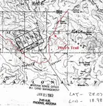
I hope this document is able to be posted. It is a copy of the Mike Bilbry claims, the LDM 1-7. It covers a large area. It's not a very good copy. Hope this helps some. There is a twist to the Bilbry claims and I am looking for another BLM document, when I find it I will try and copy it.

Matthew K. Roberts

Mike's claims.jpg
 

Last edited:

Top Member Reactions

Users who are viewing this thread

Back
Top