The "Peralta" Stone Maps --- On Their Own

....bAlthough you may consider that part of my theory adressing the caching of the stones, based partly on the reports of Keller's aborted entrada,as thin, I do not.
I do expect to be able to "fatten it up some" ( as it was more recently put to me in a FB post by a trusted friend ) , after our next visit to the map area and heart(s). ....

J. Frank Dobie []| Texas State Historical Association (TSHA) was simply a collector/writer/publisher of Texas and SWestern history, in the same way that Tom Kollenborn is today. He passed on stories he had collected, including those about Peg Leg's adventurism in both his articles and his books. ...
Regards:SH.
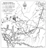
Well, OK, 'thin' in the following regard. You assert in post 737 that Keller likely used Kino's 1701 map for his trip to the Hopi mesas, which is a fair and, I believe, accurate assumption. The route from the Gila to today's Camp Verde was logistically relatively easy, despite the pervasive Indian threat. From there to the Hopis, the way had been known and used by Spaniards since the days of Espejo and Farfan, dating back to the 16th century. Kino's map seems to indicate this travel route.

The Queen Creek theory rests on Keller's knowledge of the 'Indian trail' shown on the military map in post 749. We can see how the military would be aware of it in 1867, but in 1843 we don't have any indication if and how the trail would have been known to Keller. Based on the section of trail shown on the map, it seems irrational that Keller would have intended to reach the Hopi mesas using this rugged route. Of course, the whole trip could have been a secret, but that requires an unsupported leap of faith so far. I'm not saying you are wrong, but in order to fatten the idea, you need to expand more on this other trail, IMO.

Re Tumlinson, he may have been an innocent dupe, a co-conspirator in a disinformation campaign or just a lucky guy, but if I were spending energy on these stones, I would be cautious about him. I am not a believer in coincidences.

Re Dobie, he is one of a group of 'treasure writers' that seemed to surface ca 1930's. I believe most of their writings are disinformative, whether intentionally or unintentionally. These guys have since been followed by a legion of paraphrasers. Kollenborn and others who write about LDM, etc. are a hundred years too late to shed new light on the subject.

espejo.jpg
 

Last edited:
All,

Wayne wrote:

quote_icon.png
Originally Posted by Hal Croves
Well, I am not sure that the dates work. If they were found in 1924 (the Tucson Artifacts), then there is a small chance that they are related. But it is almost too early in the timeline of this mans life.... almost. The connection that leaves me wondering is the composition of the lead and the source of that lead... and obviously the discovery story. If the lead did come from auto batteries of the period, then we need to consider a possible connection. Honestly, cactusjumper's ideas on the Tucson Artifacts (regarding "who") are in my mind worth re-reading.

The road along which they were discovered. Silverbell Rd. In 1924, do you know what this road was used for? I mean, where would it take one if one were to go anywhere using it? In both directions?


Another possible source for the lead was mentioned by one of the professionals who ran the analysis of the samples taken from the artifacts.
Some of the samples he tested showed antimony in the same proportions as lead type, as used and recycled for printing presses.
Lead was used for many things, still is, such as the solder used for sealing the tin cans of the day, or any other tinwork for that matter.
Also used for body filler in automotive production,customization (lead sleds) and repair up until the 1960's or so.
The location where the "artifacts" were found was a former lime kiln/crushing/quarry operation, probably related to late 19th-early 20th century construction in the Tucson area. Silverbell Road would have provided access to that operation , and the dust from the crushing would have provided the "caliche" which with annual rainfall would have permiated the layers in which the "artifacts" were found. In my opinion, these factors negate any proof that the soil conditions at the site and provinience of the castings seem to suggest.
I for one, see no viable connection between the Stone Maps and the T/As, and will not be wasting any of my own time trying to make one.
____________________________________________________________

Calalus first popped up on the LDM Forum back in 2007.
Lost Dutchman Gold Mine - Arizona Superstition Mountain Wilderness - Gold Mining ? Search

On occasion, whenever Ben Davis gets bored, he does further posting under a number of different names.

Prior to those first posts, I had become interested in the Tucson Artifacts. Since those early days I have gathered quite a large amount of literature on the subject. I have studied both sides of the debate, and spent a great deal of time and money.

Some of the material I have is almost impossible to come by today. The best source on the artifacts is "Journal of the Southwest" Volume 51-Number 1-Spring 2009. A great deal can be found on the Internet. "Caliche In Arizona" by J. F. Breazeale and H.V. Smith will give you some background on caliche. Mr. Braezeale gives a well Qualified opinion on the caliche associated with the Tucson Artifacts.

Thomas Bent's manuscript is available at a few of the Historical Societies in Arizona. Along with the manuscript, there are a number of letters that passed between Bent and the McGees of LDM fame.

Finally there is Professor Cyclone Covey's book, "Calalus". That book is easily available.....I believe.

Once you get through the many posts on the LDM Forum, as well as here, you should be in a good position to make your own conclusions.

Good luck,

Joe Ribaudo

Forgot to mention "Epigraphic Society Occasional Papers", Volume 19-1990.
 

Last edited:
You're lucky you haven't been along on the ones where even I wondered if I could make it back. I've been in situations like that which cost Jesse C. everything, only I made the decision every time to go back and around, no matter how long it took or hurt to do so. Hit the bottom end of a wash one time, near the end of a long day on Black Cross Butte, over a thousand feet down from the peak and in a narrow slick-rock chute at the top of a dry waterfall. I even went so far as to rig the ropes and let them dangle over the lip. With 100' of lay, it looked like they just about reached the bottom. But I had nothing left for a safety margin or to rig a release for the ropes. So I let common sense win me over, and hauled my sorry a-s back to the top and home the long way instead. At least I now know there's nothing down there, but another place to fall off of.
Probably worth a drive out to the other bridge for a look around. Any group headed into the sups from the south end might follow the high bank as far as they could.
It's higher and much easier going than straight in from the Hwy 60 bridges and would have offered additional places to make caches as well. We still don't know exactly where the Latin Heart was found.Those who discount it's significance are paddling with one oar IMO.

Best:Wayne

Paul:
Good to hear you're still in the game. Did you manage a spring break hike or two ?
Been meaning to give you a shout, but got all caught up with this newer stuff.

best:Wayne

Hi Wayne,

As luck would have it (bad this time), I should have been flying home today after a hiking/exploring trip to the Superstitions. Unfortunately, real life and work got in the way at the very last second and I had to cancel the trip as I had to make preparations for a trip for work instead.

I like to think that maybe "Someone" was looking out for me and I just wasn't supposed to go on this trip for some reason.

I'll try to get out there again this fall.
 

Well, OK, 'thin' in the following regard. You assert in post 737 that Keller likely used Kino's 1701 map for his trip to the Hopi mesas, which is a fair and, I believe, accurate assumption. The route from the Gila to today's Camp Verde was logistically relatively easy, despite the pervasive Indian threat. From there to the Hopis, the way had been known and used by Spaniards since the days of Espejo and Farfan, dating back to the 16th century. Kino's map seems to indicate this travel route.

The Queen Creek theory rests on Keller's knowledge of the 'Indian trail' shown on the military map in post 749. We can see how the military would be aware of it in 1867, but in 1843 we don't have any indication if and how the trail would have been known to Keller. Based on the section of trail shown on the map, it seems irrational that Keller would have intended to reach the Hopi mesas using this rugged route. Of course, the whole trip could have been a secret, but that requires an unsupported leap of faith so far. I'm not saying you are wrong, but in order to fatten the idea, you need to expand more on this other trail, IMO.

Re Tumlinson, he may have been an innocent dupe, a co-conspirator in a disinformation campaign or just a lucky guy, but if I were spending energy on these stones, I would be cautious about him. I am not a believer in coincidences.

Re Dobie, he is one of a group of 'treasure writers' that seemed to surface ca 1930's. I believe most of their writings are disinformative, whether intentionally or unintentionally. These guys have since been followed by a legion of paraphrasers. Kollenborn and others who write about LDM, etc. are a hundred years too late to shed new light on the subject.

View attachment 797741

Springfield:

I do enjoy these debates, particularly this aspect of Stone Map history.
With so many theories worth considering, along with an abundance of evidence so contradictory in nature, the actual location and circumstances of T.Tumlinson's discovery may remain in doubt for at least the forseeable future. Even if and when the fat lady sings, there may remain some degree of doubt.
My own suspicions suggest that no record of Keller's trip of 1743 would have been made to anyone other than his immediate superior, if one of the king's soldiers had not been lost and the party had not been forced to return without their animals and cargo/supplies. Inquiries would have been expected, and questions raised about how and where the raid occurred. Perhaps even the location of the soldier's grave itself. The report, even abbreviated as we see it, gives both a plausible location (close by the Apache stronghold) and a plausible reason for the loss (apache raiders). Although any other route taken toward the Moqui area, which is shown as such on other maps as well as Kino's, could have brought them into contact with hostiles, there were none which IMHO, would have required the reference to the "sierra" mentioned in the account of Keller's journey.
As I've stated, I believe that Keller's trip was actually for the purpose of caching a shipment of valuables and to place the stones in a location closer to the place in the mountains to which they apply. I also suspect this was the first and last time any such attempt to place the stones within the mountains was made, although shipments may have continued via a safer route.
BTW...Travis' uncle "old Robert" Tumlinson did once claim that they found the stones along the Apache Trail somewhere, and that the treasure they refer to was buried out in the desert below the mountains somewhere. So there's another bit of trivia to consider as well.

Regards:SH.
 

Last edited:
Paul:

I hope you can make the Rendezvous. Might have a couple of interesting snapshots to show you by then. I'll get some glossies done up.
I hope we can get out for at least one hike together this year. I'm still hoping to get you up to that cache I mentioned a couple of years back.
I'd still like to get your opinion of it's location and view, relative to Watz's sketch.
Your "thought" has been shared many times lately. I hope for good reason.

Best:Wayne
 

Last edited:
G'morning Ladies & guys: since I have never had this in my sights as a full time target, I frankly do not have much to contribute, other than an opinion which is probably far off base, buttt---

First, who, other than Sr Reavis, would actually benefit by finding them?? They would have bostered his claim to The Peralta Land Title. But as they say " many a plan by mice and man goes astray."
Could you send some one from Spain, or even Mexico city to that spot, regardess of how detailed the instructions were?


An extemely interesting story which tends to completely demolish me is -->

http://freepages.genealogy.rootsweb...rticles/Are the Peralta Stone Maps a Hoax.pdf

Cactus is just sneaky enough to actually have the answer.

As for poor Dobie, while he was/is a extremely interesting author, he does stretch things a bit. For example he was never at Tayopa in his trips. The episode where he was camped when the mule drivers shared their corn, then blew a horn to find Tayopa, is exactly as wrtten, it 'is' one of the entry's to Tayopa. has an actual basis as he described it, but he was not there. This, one can tell that knows the area.

Yes, at the head of the Parmo, the physcal configurations will give three echos, but in decreasing tone. Cubber can fill you in why.


Bk to the Stone maps,

Don Jose de La Mancha
 

Last edited:
Thank you.

I wonder if the requiered percentages are the same? Lead type (i would think) would need to have a higher percent because of potential wear. A battery is stationary and only needs to hold its shape.

Either way, I don't know enough about the TA to make a call. If they are a hoax of some type and made from automobile batteries of the 1920's, then there is a connection to the person I believe carved the stones. It is circumstantial.

I would like to read your thoughts on the DON stone, specifically the usage of that word. If it is a ref. to ownership, why do you think the surname was excluded? I wonder why we don't describe the stone maps, the cipher, as the DON Stones?
"As I've stated, I believe that Keller's trip was actually for the purpose of caching a shipment of valuables and to place the stones in a location closer to the place in the mountains to which they apply".

Why? Why hide something valuable and then hide the map to it in the same general area? Wouldn't the maps have been kept close to home? Why not on parchment or something similar? The whole thing has come to feel a bit theatrical. The stones that is. And for me that is a clue.

If one believes that the system/language of treasure signs & symbols was used in the inscriptions, then there should be a signature. Any thoughts?

The fact that they are dimensional, 3d with 2d inscriptions inscriptions... makes me wonder if that was an intentional mechanism/layer of ecryption. It did get people thinking 3d for an answer.

They are a modern work. This realization was/is a HUGE disappointment to me.

But, at the same time, I feel that there is something to be rediscovered preserved in the stones. The trick is to live long enough to learn it. Yes, and not to get excessively nutty in the attempt.
 

Thank you.

I wonder if the requiered percentages are the same? Lead type (i would think) would need to have a higher percent because of potential wear. A battery is stationary and only needs to hold its shape.

Either way, I don't know enough about the TA to make a call. If they are a hoax of some type and made from automobile batteries of the 1920's, then there is a connection to the person I believe carved the stones. It is circumstantial.

I would like to read your thoughts on the DON stone, specifically the usage of that word. If it is a ref. to ownership, why do you think the surname was excluded? I wonder why we don't describe the stone maps, the cipher, as the DON Stones?

Samples were taken from several objects. The results showed a variance of elements, chiefly antimony, of differing percentages consistent with both batteries and type. A couple of them were outside the range, but this would be expected if scrap lead from various sources had been used as well. There has been two sets of such testing done. I doub't there will be any more. Just like the stones, without organic material for dating purposes it seems pointless.
I did suggest once, that perhaps they had been cast for some kind of Hollywood production during the early days of silent film. Many such epics never made it to final production, and their props wound up in the junkyard, which the place where they were found was also used for. Some survived and wind up on E-Bay now and then. Lots were made of lead.

Not sure yet how the "DON" works, but it doesn't seem to me to refer to a Don.
Could be an acronym.
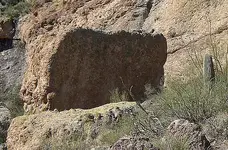
There is a boulder visible in one of my photos which appears to have a bas relief "D" on the visible surface.It's just about 100' to the left and behind the 25'x30' reverse D-shaped rock with the faint two vertical lines and cross.The "DON" is reversed,with the map upright, so both backwards D's wind up at the same location on opposite sides of the stone.
The bas relief boulder, maybe about 5' across, might be meant to draw attention to this. There does seem to be a connection.
There could also be an O and N nearby, but I don't know that there is. I'll have to look around some more.
I think I have a good target for this fall's run, so we'll see how it goes.

Regards:SH.

View attachment L Trail crop1.bmp View attachment Ltrail crop.bmp Start Mark Boulder enl.png
 

Last edited:
BTW...Travis' uncle "old Robert" Tumlinson did once claim that they found the stones along the Apache Trail somewhere, and that the treasure they refer to was buried out in the desert below the mountains somewhere. So there's another bit of trivia to consider as well.

That is amazing. Will you share the source? When he said the "Apache Trail somewhere", where do you think he was describing? Makes sense. Get everyone digging along Queens Creek while the true discovery site remains a secret. Weren't the crosses found off the same trail?
 

"doub't there will be any more. Just like the stones, without organic material for dating purposes it seems pointless."

The technology is there to date the stones and once something of merit is found using them, they will have to be dated. If you turn out to be correct, wouldn't they fall under some antiquities act? They will be examined closely once someone posts the right photo.

I read somewhere about a polished surface indicating a high speed instrument in the carving process. If that turns out to be correct, your theory, regarding the date, is done.

Do you know of any locations along or just off the Apache Trail that are at the elevation of 1847?

And one last question. Where, in your opinion, were the stone crosses found?

Thank you.
 

Last edited:
BTW...Travis' uncle "old Robert" Tumlinson did once claim that they found the stones along the Apache Trail somewhere, and that the treasure they refer to was buried out in the desert below the mountains somewhere. So there's another bit of trivia to consider as well.

That is amazing. Will you share the source? When he said the "Apache Trail somewhere", where do you think he was describing? Makes sense. Get everyone digging along Queens Creek while the true discovery site remains a secret. Weren't the crosses found off the same trail?

I was wrong...it was Bob Shultz, a friend of Travis', rather than Ucle Bob who mentioned the Apache Trail.
Unfortunately, he goes on to describe the Queen Creek site, so he was obviously confused.
From Gary's website:

View attachment Bob Shultz Apache Trail.bmp

Bilbrey said he found the Crosses while digging out a filled in mine shaft on the SW side of Tortilla Mountain.
He was granted permission to continue his digging, based on the fact that there was some gold in the old mines.

Regards:SH
 

Interesting article.
He found the one.
Deciphered it by himself in a short time,dug up the others with a prince albert can,in our Az dirt,3 feet down,got fired on, then went to phoenix and there was an article already in the news paper.
Plus he was by himself with no wineses.
I do not really think a prince albert can can dig our dirt.
I mean,when i put in a sewer line,like I am doing now, I need my sharp shooter, and a rail road bar to go down 1 foot.
 

I was wrong...it was Bob Shultz, a friend of Travis', rather than Ucle Bob who mentioned the Apache Trail.
Unfortunately, he goes on to describe the Queen Creek site, so he was obviously confused.
From Gary's website:

View attachment 798668

Bilbrey said he found the Crosses while digging out a filled in mine shaft on the SW side of Tortilla Mountain.
He was granted permission to continue his digging, based on the fact that there was some gold in the old mines.

Regards:SH

On the highway to Queen Creek does not mean at Queen Creek. On the highway is anywhere. But it is curious that he mentions the Apache Trail.

The last sentence is what I am confused about. Are you familiar with the article in the paper regarding his discovery?

"The next morning he studies the the stone and figured out from its symbols where to locate the other buried stones."
This is makes absolutely no sense. That would put everything around the discovery area and the scale, extremely small.

Can one camp at the site today undetected?

Do you know why Bilbrey stopped working the site?

Thanks.
 

Antimony........

One of the assay reports done on the lead from the Tucson artifacts, showed a 10.36 percent antimony content. That is unusually high. Even two percent is considered high.

"At Bent's request, William C. Root of Bowdoin College, who analyzed many metal artifact from archaeological sites during the mid-twentieth century, examined the metal in the Tucson artifacts. In a letter dated august 4, 1958, he reported to Bent that, I have come to the conclusion that the objects are more than 200 years old, and very well may be less."

Joe Ribaudo
 

"doub't there will be any more. Just like the stones, without organic material for dating purposes it seems pointless."

The technology is there to date the stones and once something of merit is found using them, they will have to be dated. If you turn out to be correct, wouldn't they fall under some antiquities act? They will be examined closely once someone posts the right photo.

Any testing would only be of value if the original stones, rather than copies are tested.
If any testing can show conclusively that any of them are older than 100 yrs, the act would apply...NASA - Archeology


I read somewhere about a polished surface indicating a high speed instrument in the carving process. If that turns out to be correct, your theory, regarding the date, is done.

Source:http://freepages.genealogy.rootsweb.ancestry.com/~gcundiff/LostDutchman/peralta/Arizona Highways.pdf
Same thing...some copies may have been made using stones gathered from various sources which may have been prepped and even carved using modern power tools. Travis was afraid the stones would be stolen and may have even made a set of copies himself, using both a dremel with a "duplicator" setup and hand tools.
If so, his wife may have sold this set to Mitchell. We know many sets of copies, both cast from moulds and carved, were made after that. Documents in the Cundiff collection mention two sets of stones shared among the principals of MOEL.


Do you know of any locations along or just off the Apache Trail that are at the elevation of 1847?

I looked into the possibility, and the history of barometric altimeters about three years back. A. Kirchner popped up, but there were too many places with that altitude in the mountains. I mentioned it back then.

And one last question. Where, in your opinion, were the stone crosses found?

I suspect Bilbrey was telling the truth about where he found them. He may have thought the claims he filed protected his interests, and saw no reason to lie.
But to me they seem to be an earlier version of the Stone Maps.
I suspect they were discarded when they became obsolete.


Thank you.

Regards:SH.
 

On the highway to Queen Creek does not mean at Queen Creek. On the highway is anywhere. But it is curious that he mentions the Apache Trail.

The last sentence is what I am confused about. Are you familiar with the article in the paper regarding his discovery?

"The next morning he studies the the stone and figured out from its symbols where to locate the other buried stones."
This is makes absolutely no sense. That would put everything around the discovery area and the scale, extremely small.

Can one camp at the site today undetected?

Do you know why Bilbrey stopped working the site?

Thanks.

Hal,

Perhaps he left the site to serve his time in prison for selling a fake cancer cure to terminally ill people.:dontknow: Good luck following that particular pied piper.

Take care,

Joe Ribaudo
 

Last edited:
Interesting article.
He found the one.
Deciphered it by himself in a short time,dug up the others with a prince albert can,in our Az dirt,3 feet down,got fired on, then went to phoenix and there was an article already in the news paper.
Plus he was by himself with no wineses.
I do not really think a prince albert can can dig our dirt.
I mean,when i put in a sewer line,like I am doing now, I need my sharp shooter, and a rail road bar to go down 1 foot.

Christmas 1948...Travis, travelling with wife finds first H/P stone on way back to Hood River from ancestral home in De Witt county, Texas.
I think he may have decided to check out one of his grandfather "Peg Leg"s old maps, which he may very well have obtained during that Christmas visit.
I also think a view of Weaver's Needle was important to the location shown on the map, as was the creek.
1949..not sure when,but probably Christmas again, Travis with his uncle along stops once again at the same place, after having spent some time trying to understand the H/P stone, and digs up the other three pieces about 60' away from where he found the first.
The area where he claimed to have found them has plenty of soft gravel and sand mix. You can dig it there with your foot.
Further east, along the high bank of the creek, it's like concrete. Except those places where it's been dug and filled in before.
Probably the easiest way to find a cache out there, without markers, would be to look for shallow sinks.
 

On the highway to Queen Creek does not mean at Queen Creek. On the highway is anywhere. But it is curious that he mentions the Apache Trail.

The last sentence is what I am confused about. Are you familiar with the article in the paper regarding his discovery?

"The next morning he studies the the stone and figured out from its symbols where to locate the other buried stones."
This is makes absolutely no sense. That would put everything around the discovery area and the scale, extremely small.

Can one camp at the site today undetected?

Do you know why Bilbrey stopped working the site?

Thanks.

Actually, I think somewhere along the Apache Trail would have been a better place for a discovery site if someone were trying to perpetrate a fraud.
The Apache Trail is better known to both general historians and treasure hunters as the main route into the Sups. It also is convenient to the Massacre Grounds, which any intelligent con-artist would see as an ideal place for them to be found IMHO. Then they could be easily linked to the Peraltas.
I've never seen the article, but if there was one it may have been something old uncle Bob was responsible for. Could the article have actually appeared at the time of the second trip, after old Bob decided a little publicity couldn't hurt ? Could he have called ahead ? There is also the possibility that someone at the gas station where people saw Travis washing the stone or stones, called the newspaper to report it. All of the details are confusing, mostly because none of it was recorded for 20 years or more. Until Travis and his wife both died, no one outside of his family and and a small group of five friends even knew of the stones existence.

It does make some sense, when you consider that he is only talking about the stones themselves, so the scale doesn't factor.
Tumlinson only claimed to have used this to find the other stones....
View attachment 3-N2-P.bmp

Depends on where you choose to set up camp, but both the Tumlinson site and Bilbrey's sites have plenty of places where a camp would be out of sight to passerby. A vehicle might be harder to hide at the QC location, but not impossible. A 4x4 could be concealed in one of the ravines that cut through the high bank, for example.

Bilbrey ran out of money. He had quit his job in California in order to pursue his prospecting full time. He had a couple of backers for awhile, but they backed out when he didn't find much. He got involved with Jim Humble [http://www.guardian.co.uk/science/2010/sep/15/miracle-mineral-solutions-mms-bleach], who was marketing a snake-oil cure for malaria and everything else without FDA approval and got sentenced to a well deserved stay in Yuma prison, while Humble slipped across the border to Mexico, where he's still in business. It's been claimed that one condition of his probation was that he end his search for treasure. Someone who knows him has said he is still going out there occasionally. I may have stopped by his camp a couple of years ago. It was an interesting conversation with a stranger, and for over an hour, who wouldn't tell me his name.
No reason to follow him though. He was and probably still is searching the wrong places. Everything shown on both of the Stone Crosses is in the SM area, so we don't need the Crosses either. The Latin Heart we do.

Regards:SH.
 

Last edited:

Top Member Reactions

Users who are viewing this thread

Back
Top