The "Peralta" Stone Maps --- On Their Own

Hal

I read your comments and remember seeing this on another site. May be of help.

bdavis wrote on Mar 31, 2013 7:54 a.m.:
An examination of the specifics regarding the dig will show that the artifacts were not made from automobile batteries. That is unless the automobile batteries in the 1920s were made in the 1870s. You see a tree grew over one of the artifacts that was dated back to the 1870s. A thorough scientific study of the composition of the artifacts will show the lead and antimony content of the artifacts actually proves nothing regarding whether the artifacts are real or not. Perhaps the artifacts tell us an incredible story that is verified in the land and history of the southwest. A small work to start with to understand the history of Calalus is Arizona in the 50s, by Travis. There is no finer work than Bent`s work the tucson artifacts, to understand the dig.
b.davis wrote on Apr 1, 2013 11:22 a.m.:
Sorry about the spelling. The book, "Arizona in the 50`s, was written by Captain James Tevis. The pertinant pages are from 132-137.
Kenny wrote on Apr 10, 2013 4:50 p.m.: from www.azpm.org
Anyone want to swordfight with a lead sword?
Ridiculous to think someone would travel across the world with such a useless 'artifact'.
bdavis wrote on Apr 11, 2013 12:10 p.m.:
I dont believe anyone has ever taken the position that the artifacts were brought to America. In fact the history that is recorded on them speaks to events in the Americas. As far as the metallic composition of the artifacts, there are several mines in the area that have ore that could have been used to create the artifacts. Such as the Old Padre Mine, the Old Yuma Mine, and Goat Ranch.
Whether or not a sword made with lead and tempered with antimony works, who knows? Imagine the folks who created all of this were in a better position to answer this question.

If the above is true there is no connection? I guess it is possible the Tucson Artifacts are real and have something to do with the Superstitions and all the maps are modern creations, created by their descendants to run people crazy. if so they did a good job. Maybe what is important is where the maps do not lead not where they do lead.

Cactus Jumper,

Thanks for posting the pictures. Didn`t you indicate there were monuments up there somewhere that were destroyed? Wonder Why?


Tom
 

Last edited:
..... Well, the stones were not lost to history. Remember, one was protruding from the earth when found. Amazing when you try to reason how something buried intentionally can make its way to the surface. ....

And the reverse side of this coin is that the stones weren't 'found', releasing them from their 'lost' state, but that they were 'introduced'. I for one agree with your opinion that the stones are modern creations based on modern source data (20th century). This blows the simple 'Spanish gold' scenario, but IMO acknowledges the complexity of the conspiracy the stones have become a part of.
 

Hal stated: Well, the stones were not lost to history. Remember, one was protruding from the earth when found. Amazing when you try to reason how something buried intentionally can make its way to the surface. Here, where it gets very cold, stones are forced to the surface with the freeze and eventual thawing. Knowing the climate and composition of the earth where the stones were discovered, I wonder if this process is even possible in that location. I honestly do not know.


Hal,

First of all the location where everyone believes the stone maps were found near the US 60 bridge crossing Queen Creek at a construction site and to include my earlier map (as I was going by memory) is in-correct. I have just received a file from Greg Davis that gives the exact location and it matches the same area that Bob Brewer and I had examined back in 1998.

The first thing that entered my mind when we drove to the site was the vast amount of rocks and stones laying everywhere! I told Bob that no one would not be able to pick out the corner of a specific rock with writing on it by just simply tripping over it, there are thousands of rocks lying all over the place. Bob then told me that it was not found by accident. The bridge is located at mile 33.6 on the "Old Way", El Camino Viejo that crosses Queen Creek heading east from US 60.

The process you described above would not take place in this area. Flash flooding can occur, but the stones were buried/hidden on high ground. The group never left signs, symbols or witness marks anywhere near areas that were prone to flooding. Also, just for fun, this is important. Take an exact heading of the Florence Junction Airport on a south/west to north/east heading, should be 39.39 degrees. This figure is very close and must be done on a USGS Florence Junction 7.5 Topographic map in a PDF version. Select (click on) "Tools", click analysis and select measuring tool. These tools are very precise and a 39 degree heading is close enough 39=3333=absolute truth.

By the way; the witness marks will be the number nines that will correct you if you are wrong (use the north runway border as your line guide).

I need to go back to the site and find the on/ground witness mark as I cannot remember what it was. Somehiker, interested in an early morning run?

Later,

Ellie B
 

Last edited:
Wayne
They sell a UV flashlight for bug and rodent detection. You can get one at wmart, Home Depot. A tool every treasure hunter should have. Buy one and the next time your in that cave check the plug area where it meets the cave wall. A UV light can show a difference in material used. Won't be a fluorescence but a difference can be detected. A example would be my fireplace brick. I reprointed some spots and those areas show up under a UV light. Someone puts a hole in a adobe wall and refills the hole after hiding something. 100 years later you can still see that with a UV. In addition to my other duties I processed crime scenes. A UV light is a very handy tool. Wonder if anyone ever examined the genuine stones with one. Hal you thought a tracing may have been used to carve the stones. There still could be traces of that on the stones
Oh Wayne after you get one shine it on your hotel bed sheets. You won't sleep so tight.
 

EB I live at 101 and 60. Though not a stoner at this point I don't object to a hike with friends. Now what Wayne does in some areas you could call a death march rather than a hike.
 

First of all the location where everyone believes the stone maps were found near the US 60 bridge crossing Queen Creek at a construction site and to include my earlier map (as I was going by memory) is in-correct. I have just received a file from Greg Davis that gives the exact location and it matches the same area that Bob Brewer and I had examined back in 1998.

I saw Greg's notes and photos from his visit(s) to that area when I was out there this past fall - I didn't make copies, but I will next time because I'd like to go there myself. It's the reason I suggested awhile back that there wouldn't even be a concensus as to where the stones were found. I've heard of at least 2 other locations that folks swore they were 100% confident that the stones were found, and all the locations are different.

Just goes to show the degree of misinformation that's out there regarding this legend.
 

.... Look at Mr. Forrest Fenn's treasure, relatively new compared to the PSM's. Look at all the different places people have found where the clues line up. Mr. Fenn didn't have to know about all these different places to write his waybill, did he.

Homar

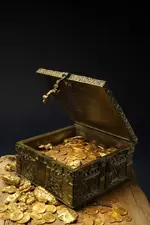
A million dollar payoff in gold (photo below). Beautiful forested, watered terrain. Great Mexican food. No digging required. Guaranteed to exist. Fenn's clues are tricky too, though. Even so, for the money-motivated adventurers, this sounds like a better gamble than the Superstition snipe hunt.

2013-04-05-TREASURE.jpg
 

Last edited:
Wayne
They sell a UV flashlight for bug and rodent detection. You can get one at wmart, Home Depot. A tool every treasure hunter should have. Buy one and the next time your in that cave check the plug area where it meets the cave wall. A UV light can show a difference in material used. Won't be a fluorescence but a difference can be detected. A example would be my fireplace brick. I reprointed some spots and those areas show up under a UV light. Someone puts a hole in a adobe wall and refills the hole after hiding something. 100 years later you can still see that with a UV. In addition to my other duties I processed crime scenes. A UV light is a very handy tool. Wonder if anyone ever examined the genuine stones with one. Hal you thought a tracing may have been used to carve the stones. There still could be traces of that on the stones
Oh Wayne after you get one shine it on your hotel bed sheets. You won't sleep so tight.

I don't worry about the bugs much. They seem to vacate when I show up. Guess they don't think I'm tasty....past my "best before" date, maybe.
A portable UV light might come in handy where we're going next visit, and probably a few other things as well. Good lighting and more than one camera for sure.Thinking of rigging up a zip-line, so a video cam can be used to shoot some low level aerials. As I said, I'm not too willing to risk opening that tunnel, since I suspect another entrance/exit further back along the bluff. Gonna check that first, before I do any more poking around the other end.

Best:Wayne
 

EB I live at 101 and 60. Though not a stoner at this point I don't object to a hike with friends. Now what Wayne does in some areas you could call a death march rather than a hike.

You're lucky you haven't been along on the ones where even I wondered if I could make it back. I've been in situations like that which cost Jesse C. everything, only I made the decision every time to go back and around, no matter how long it took or hurt to do so. Hit the bottom end of a wash one time, near the end of a long day on Black Cross Butte, over a thousand feet down from the peak and in a narrow slick-rock chute at the top of a dry waterfall. I even went so far as to rig the ropes and let them dangle over the lip. With 100' of lay, it looked like they just about reached the bottom. But I had nothing left for a safety margin or to rig a release for the ropes. So I let common sense win me over, and hauled my sorry a-s back to the top and home the long way instead. At least I now know there's nothing down there, but another place to fall off of.
Probably worth a drive out to the other bridge for a look around. Any group headed into the sups from the south end might follow the high bank as far as they could.
It's higher and much easier going than straight in from the Hwy 60 bridges and would have offered additional places to make caches as well. We still don't know exactly where the Latin Heart was found.Those who discount it's significance are paddling with one oar IMO.

Best:Wayne

Paul:
Good to hear you're still in the game. Did you manage a spring break hike or two ?
Been meaning to give you a shout, but got all caught up with this newer stuff.

best:Wayne
 

Last edited:
Wayne I was referring to stains on the sheets not bugs. You do rent the room by the hour?

:laughing7:....Nah, by the week. Gettin old and it takes me longer.
Mostly...by the time I catch up with them, I forgot why I was chasing them in the first place, and all I really wanna do...is have a nap.
 

Last edited:
EB I live at 101 and 60. Though not a stoner at this point I don't object to a hike with friends. Now what Wayne does in some areas you could call a death march rather than a hike.


sgtfda,

Send me your phone number in a pm. I'll give you a buzz early in the week. I can't do the forced marches any more until I get this spur out of my right foot!


EB
 

Hello all.
I will just post this once for all to see,instead of pming all of you guys, or mostly the ones who know each other.
Anyway,I live over here by Queen valley.
A lot of you know me by my postings.

If springfield or secret canyon look at my profile pic you might see something you recognize.
Anyway,here is my phone number,cell phone.
If any of you want or need a hand, or someone to go with you, call me, and i can be there in 15 minutes if i am not busy.
I have my own construction, home remodeling company so i am available when ever i want to be.

520*827*nine038
Matt
I wrote it like this so phone spam bots wont pick it up.
Mention Tnet when you call with your username.
 

Well, I am not sure that the dates work. If they were found in 1924 (the Tucson Artifacts), then there is a small chance that they are related. But it is almost too early in the timeline of this mans life.... almost. The connection that leaves me wondering is the composition of the lead and the source of that lead... and obviously the discovery story. If the lead did come from auto batteries of the period, then we need to consider a possible connection. Honestly, cactusjumper's ideas on the Tucson Artifacts (regarding "who") are in my mind worth re-reading.

The road along which they were discovered. Silverbell Rd. In 1924, do you know what this road was used for? I mean, where would it take one if one were to go anywhere using it? In both directions?

Another possible source for the lead was mentioned by one of the professionals who ran the analysis of the samples taken from the artifacts.
Some of the samples he tested showed antimony in the same proportions as lead type, as used and recycled for printing presses.
Lead was used for many things, still is, such as the solder used for sealing the tin cans of the day, or any other tinwork for that matter.
Also used for body filler in automotive production,customization (lead sleds) and repair up until the 1960's or so.
The location where the "artifacts" were found was a former lime kiln/crushing/quarry operation, probably related to late 19th-early 20th century construction in the Tucson area. Silverbell Road would have provided access to that operation , and the dust from the crushing would have provided the "caliche" which with annual rainfall would have permiated the layers in which the "artifacts" were found. In my opinion, these factors negate any proof that the soil conditions at the site and provinience of the castings seem to suggest.
I for one, see no viable connection between the Stone Maps and the T/As, and will not be wasting any of my own time trying to make one.

Don't know if you have looked into this story, but for those who are trying to connect the landing strip at Florence Junction with the PSM's, it might be of interest.
Lost Treasure: Leon Trabuco?s Gold | Strange Mysteries and Unexplained Stuff

There was also a lengthy discussion on this site re: the same topic.
http://www.treasurenet.com/forums/treasure-legends/17326-17-tons-gold-new-mexico.html

More here;
http://www.treasurehuntersuniversity.com/tons.html

Not suggesting a direct link, time and distance being a problem, but Trabuco did purchase fuel at Winslow according to the reports.
But who knows, perhaps some other group conducted a similar operation at some point in time, using the airstrip at Florence Junction.

Regards:SH.
 

Last edited:
I understand your theory, but so far I find it a little thin. Of course, you could be correct, but I guess I'd have to know more about the 'Indian trail' to understand how Keller would have justified his choice of using it instead of the better-known Hopi route to Vildosola.

The stones. They always feel like a square peg in a round hole no matter how ardently they're tied to 'Spanish gold'. I guess the whole Tumlinson connection sullies them for me: it'd be better if Dobie's name hadn't surfaced.

I know this isn't the first time you have made these arguments, or replied to the same information supplied by myself or others such as Mike.
But I think some of it is worth repeating, if only to keep it fresh.

Although you may consider that part of my theory adressing the caching of the stones, based partly on the reports of Keller's aborted entrada,as thin, I do not.
I do expect to be able to "fatten it up some" ( as it was more recently put to me in a FB post by a trusted friend ) , after our next visit to the map area and heart(s).
Although Vildosola wrote the cedula granting permission for the attempt, I doub't he would have known of any trail to the Moqui from the Pima villages on the Gila direct to the Moqui villages west of Zuni. The Pima however, may have been very familiar with this trail, especially if they were, as claimed, descendents of the Hohokam. They may have also used this trail on occasion for resource gathering and revenge raids against the Pinalenos.
For me, the Tumlinson connection fits like a glove. He came from a family directly involved in the history of early Texas, who's grandfather "John Jackson (PegLeg) Tumlinson " was himself the grandson [http://www.catbur.com/burns-mcarthur/740.html] of [SIZE=-1][SIZE=-1]John Jackson Tumlinson head of a family who settled in [/SIZE]Austin's Old Three Hundred Colony[/SIZE]. They were involved, through their generations in wars with the indians, the Spanish, and the Mexicans, as well as being well connected with the history of the Texas Rangers.[http://www.catbur.com/burns-mcarthur/1769.html]
Although I haven't purchased or read Azmula's latest article in the Superstition Mountain Journal, he does believe that the Map Stones were stolen from a courier who had died while taking them to Mexico City after they had been found during renovations of Nuestra Señora de la Asunción de Arizpe. Azmula has claimed to have obtained certain documentation proving this claim, which I will have to see before altering my own theory. As it stands, I believe that Tumlinson used a document passed down from his grandfather,great grandfather, or perhaps even his GG Grandfather to locate the stones.

J. Frank Dobie []| Texas State Historical Association (TSHA) was simply a collector/writer/publisher of Texas and SWestern history, in the same way that Tom Kollenborn is today. He passed on stories he had collected, including those about Peg Leg's adventurism in both his articles and his books. His work with the Texas Folklore Society brought him into contact with members of the Tumlinson family who likely provided him with his material. Prior to the Life Magazine Stone Map Issue of 1967, he makes no mention of the stones which I have been able to find. I see nothing suspicious in his later involvement at all.

Regards:SH.
 

Last edited:

Top Member Reactions

Users who are viewing this thread

Back
Top