The "Peralta" Stone Maps --- On Their Own

Wayne,

"I AM sharing my understanding of all FOUR pieces,including the Trail Stones."

I understand that to mean that you don't believe the trail maps show canyons.
:dontknow: Would that be correct?

Take care,

Joe
 

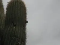
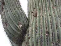
Saguaro with Pointer Rocks

sgtfda

In Storm account , you say about the Roy Bradford story when he found in the junction of Needle Canyon and Bluff Spring Canyon an big cactus with rock marks in it ?

Marius
Marius,

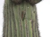
Here are three examples that would best define rocks stuck in the flesh of the saguaro. Or did you mean marks made in a saguaro's flesh?


IMG_4362.JPGIMG_4363.JPGIMG_4364.JPG

This type of sign is rare to find, however they are out there. These pointer rocks usually point in three different directions and each one must be followed through for each one could lead you to another sign/symbol or lead you to nowhere. When these photographs were taken this saguaro was at least 10 to 12 feet tall. I would have had trouble placing these flat rocks into the saguaro even on horseback.

Springfield,

The KGC used explosives almost exclusively. These folks as you say are quite inventive. You need to find someone with a ground penetrating unit that can identify caverns, tunnels or similar under ground anomalies.

Ellie B
 

Wayne,

"I AM sharing my understanding of all FOUR pieces,including the Trail Stones."

I understand that to mean that you don't believe the trail maps show canyons.
:dontknow: Would that be correct?

Take care,

Joe

Joe:

That is my conclusion, based on all I have found to date.
Here's how it works, at least what works for me.

One needs to be at the place where "SANTAFE" is scratched into the left hand side of the H/P Stone, before any of them are of use.
That place is at the intersection of two canyons, a location that would have been impossible to find without another map or set of instructions.
The trail begins there (upper line) just around the end of the mountain, and soon after you have rounded the corner you can look up and see the leaning cross. The lower line is the profile of that mountain, as it appears to someone on the trail, and ends where the Horse begins. At the end of the trail you will be standing about where I shot this...

Start Mark Boulder.png

And this....

BR Cross.png

(I now know why there is also a cross between the two vertical lines.
And a strong suspicion as to why it's not shown on the lower Map Stone.)

That's when the fun, and all that "Busca" stuff really begins.

Regards:SH.
 

Last edited:
...
We (my team) know that the group that designed the stone maps were not Mexicans and the Spanish were intentionally led away from the depository area. These people never cached anything where signs and symbols are present. We use a term describing this type of a discovery location as a "gopher cache." They intentionally left a number of gopher caches in the depository area to discourage folks from trying to steal their treasures. From our experiences they do have a small token cache for the finder if he lives to tell about it. IMHO you may be looking at such a cache....

Ellie Baba

I am curious about your book and am looking forward to a convincing demonstration that explains the stone tablets. Having said that, it's my current opinion that the stones are some sort of a diversion from the truth of whatever items of great value that may exist in the Gila/Salt vicinity.

I also believe Kenworthy, Dobie, KVM and a host of others are, intentionally or unintentionally, purveyors of disinformation regarding the many legends of 'hidden treasure' in the US. These guys might be termed 'useful idiots' in the way Stalin's ardent operatives were a century ago. I wouldn't rule HBB out of this group. It's all about providing flawed information, even by well-intentioned informants, to protect the true information. As they say, the road to hell is paved with good intentions.

I agree the folks who masterminded these plots seeded the playing field with obtainable satellite caches - difficult in the extreme to obtain, but possible. These are what all the 'signs' point to, IMO, and some have been recovered. These 'protective caches' keep the busy bees away from the true prizes, which in my opinion, are and always will be unobtainable except by their true owners.

Death traps probably do exist as yet another diversionary tactic. From a factual perspective, ie the true history of Spanish/Mexican mining in the American southwest, it doesn't take an objective investigator long to realize that nearly all the legends of 'Spanish gold caches' are laughable. More disinformation. If I were hiding something valuable and wanted another layer of security for it, I'd release a bogus cover story sending the manic crowd in the wrong direction too - wouldn't you? Sure seems strange how many 'Spanish miners' left their bullion in the American southwest instead of taking it back home with them. Sleuthing 101: if the caches exist, maybe they're not 'Spanish'.
 

Last edited:
I was thinking of Storms reference to WB Morris and other things found. I don't discount a story until I check the area. If things are found it can help date the scene. I don't care if thousands searched a site. They all do the same thing. I don't
I look at the stone incident as I would a reported crime and those involved. You have a crime scene that may shed light on who is the liar and who is not.
 

... I look at the stone incident as I would a reported crime and those involved. You have a crime scene that may shed light on who is the liar and who is not.

Exactly. It's a cold case. You want verifiable evidence, even if circumstantial. Hearsay? You don't get many convictions using rumors.
 

No need to worry about Wayne he can take care of himself. He has a safety net in Mesa just in case. Hal, Wayne's landmarks are on the money. Trust me on that one.

Sgtfda,
I am very surprised that you wrote this. On the money sounds quite conclusive for someone who is skeptical of the stones and only concerned with prospecting. Honestly, I just do not see anything in the imagry that would give me the same level of confidence.
 

Hal my eyes don't lie. What I find hard to believe is the story on how the stones were found. I've seen the area and its the last place they would have been buried. The only way is if they were dumped there by someone fleeing the mountains using the creek as a reference.
 

Both actually. The one before and the one after.
Same handiwork at all three places.
That's why I was looking there.
Sending another map now.

Best:Wayne
 

Might pay to have a look at whats above and below.
And there might be another stone somewhere, because while Tumlinson had the stones, he didn't have the answers necessary to get to the end.
 

That and the other spot. This is what happens when you take a hike with a friend. You get sucked deeper into the cactus so you can look over the next cliff. Though perhaps a surprise at the end. We just don't know what that may be. I'm my case it was a cactus spine in my end. Oh well at least there are no deer ticks and eye eating bugs like on my last project.
 

Where Were the Stone Maps Really Found?

Hal my eyes don't lie. What I find hard to believe is the story on how the stones were found. I've seen the area and its the last place they would have been buried. The only way is if they were dumped there by someone fleeing the mountains using the creek as a reference.

sgtfda,

First things first. What has convinced you that you have actually seen the area where the Stone Maps were found? What evidence do you have to support the exact location of where they would have been buried? Lastly, how can someone use a creek as a reference to the burial location?

Tomorrow is another day,

Ellie Baba
 

I find it's kinda like gettin too close to a black hole. By the time you see it, it's too late to back out.
You don't want to do what I did....once....
To sit down on a rock for a rest. Without knowing there was a cholla ball stuck to your butt.

EB:

Two things about that place along the creek...three actually.
An old trail angles down to the creek at that point, probably last used as a wagon trail, from which you could bee-line it to Florence, or maybe even the Twin Buttes.
From there it's almost due north to where Weavers can be seen...356 deg on G/E.
And it's said there was a carving of an Indian Head and two hearts somewhere there as well.....8-)

View attachment 100_0966sm.bmp
 

Last edited:
EB I should have said I've seen the area where it is said they were found.
Why the Creek? Im sure during your desert travels you spent time driving up creeks and washes. They are the roads. Why would Queen Creek not have been used as a road back then. Clear and easy path through the desert.
 

And as you travel down stream landmarks stand out. I know I use landmarks of this type to return to prospecting locations. Landmarks that are both natural and man made.
 

As you can see in the photo Wayne posted. Tire tracks. At any rate I don't know if the stones were found at that site. Only thinking if they were perhaps those that buried them were traveling the creek bed.
 

Top Member Reactions

Users who are viewing this thread

Back
Top