The "Peralta" Stone Maps --- On Their Own

The scenario might include names like Peralta and Oritz. Possibly Salazar and Gonzales and other surnames of wealthy families in Santa Fe
during the period as well.
Not all members of course, but some.
Any family with accumulated wealth would have been concerned about looting by the invaders.
How many had relatives working or living to the west,in Arizona, at that time ?
Superstitions,Bradshaws,Mineral Mountains.
Certainly some experience as you mention would apply, so add it to your list if you see the possibility.

Regards:SH.

By all reports, Santa Fe was a nasty, squalid little outpost in the early 19th century with a few hundred Spanish bureaucrats and soldiers overseeing a meager trade economy from Chihuahua to supply the Franciscan clergy's efforts. There really weren't Mexican 'ricos' because there wasn't much money or money potential for them.

After Pike's report, Americans established the fur trade out of Taos and the Santa Fe Trail from the Missouri frontier through Santa Fe and down through El Paso to Chihuahua, ca 1820 to the Mexican War. Much of the fur trade was 'off the books' because the Spanish/Mexican presence was too weak to control it. Most of the legitimate SF Trail money was controlled by the Yankees, with a few Mexican tax agents able to coerce tribute from the traders. There really weren't 'wealthy Santa Fe families' in the mid-19th century either. I don't believe there were any important Peraltas in the area during this time (I could be wrong).

There was always Indian trouble - lots of it. If Mexicans wanted to remove money from Santa Fe following the war, it seems to me an exit down the river to El Paso would make much more sense than a risky trip to Arizona.
 

These Horses are Permanent

It means I pass north of the river ,good luck
Tom

Hi Tom,

The horse referred to by the Stone Map does not pass by. When a horse is pastured it stays in a certain area or place. The horse pastures/grazes north of the river. His monument is fixed and it cannot move as it is comprised of solid rock. When used as a treasure symbol a horse is depicted showing that his reins have been dropped (hanging towards the ground). This symbol means stop here, treasure nearby.

The horse however, does have the ability to share with us what he can see. Simply look in the same direction as he is looking and/or plot a course or heading on a map that the actual shape of the image implies.

You have heard the phrase "Written in Stone"? Definition: carved in stone and engraved in stone; written in stone Fig. permanent or not subject to change. (Often in the negative.) Now, this isn't carved in stone yet, but this looks like the way it's going to be. Is this policy written in stone, or can it still be modified?

The information found on the stone maps cannot be changed or modified, so therefor the horse can be found grazing on the north side of the river, he is still there and he is not passing through.

Good luck Tom and take care,

Ellie B
 

Hi All,

Some additional Information

Written In Stone;

Introduction
by Dr. Ali Saleh al-Moghanam (and) Dr. Paul Michael Taylor co-editors / co-curators
with contributions by staff members of the National Museum of Saudi Arabia in collaboration with the National Museum of Natural History, Smithsonian Institution

The Kingdom of Saudi Arabia is rich in ancient inscriptions. They form a priceless resource for the study of the region's cultural and linguistic heritage. Throughout the country, inscriptions were etched, engraved, pecked, or even sometimes carved in bas-relief on stones or on the rock-faces of cliffs and hills. The scribe placing a text into stone (or the person commissioning that scribe) is very likely selecting the medium for its relative permanence, and usually is also selecting the location where the stone is found or placed. The difficulty of inscribing the text implies that this medium is usually reserved for matters that are of great (even, literally, monumental) importance.

Epigraphy
is the study of such texts, the science of deciphering and interpreting them. This is what I do, but not only with rocks, cliffs and hills. I also decipher maps and works of art. For example; Christ is looking at the head of a horse, this painting is woven into the "Horse of God", and El Caballo de Santa Fe legends. You have to know and follow the history of monumental importance.

View attachment Station One of Ten.bmp

Later,

Ellie Baba
 

Somehiker,

You made some good observations which you posted on Stone Map Trilogy.

You pointed out that there was an old mesquite tree growing on the dirt pile of the shallow hole later labeled as hole 5, indicating that it was not a recent dig. The PSM's would not have to be very deep, and this hole does appear to fit into the 166 year age. Sure looks like a one man job.

You also noted that there are no tall cactus near the holes. The closest saguaro has no sight hole on it. Without knowing this, I stated one time that that part of the story was made up, either by Travis or the writer. It is my opinion, that he did find the P/H stone the way he did, buried edgewise. The name Miguel etched on the top, got the best of him so he dug it out. He was not prepared for digging, so he used what he had knife, tire tools, or whatever.

I do believe he was on his way back home at the time. Anyway he took it home and studied that stone. He didn't have the others to confuse him. He was able to figure out that there could be more in that hole. He went back a year later, prepared to dig, and found the others. He took them to the station to get them cleaned. The photo of the stones on the car bumper show only the last stones he uncovered. The P/H stone was back in his house. It was there at the station, that they told him it could be a treasure map.

I don't believe he was ever passed any charts by Pegleg, nor that he made the PSM's. Yes hole number 5 is about 160 yards further that holes 1, and 1b. Safe from the construction area.

Homar
 

By all reports, Santa Fe was a nasty, squalid little outpost in the early 19th century with a few hundred Spanish bureaucrats and soldiers overseeing a meager trade economy from Chihuahua to supply the Franciscan clergy's efforts. There really weren't Mexican 'ricos' because there wasn't much money or money potential for them.

After Pike's report, Americans established the fur trade out of Taos and the Santa Fe Trail from the Missouri frontier through Santa Fe and down through El Paso to Chihuahua, ca 1820 to the Mexican War. Much of the fur trade was 'off the books' because the Spanish/Mexican presence was too weak to control it. Most of the legitimate SF Trail money was controlled by the Yankees, with a few Mexican tax agents able to coerce tribute from the traders. There really weren't 'wealthy Santa Fe families' in the mid-19th century either. I don't believe there were any important Peraltas in the area during this time (I could be wrong).

There was always Indian trouble - lots of it. If Mexicans wanted to remove money from Santa Fe following the war, it seems to me an exit down the river to El Paso would make much more sense than a risky trip to Arizona.

My scenario isn't dependent on the well known history of Santa Fe, and I'm unlikely to argue the financial status of the many names associated with commerce and trade in the area.I've perused papers such as this one for some background information...
Santa Fe National Historic Trail: Special History Study (Table of Contents)
...so I am aware of Santa Fe's backwater status during that period.

But I have also been unable to find any reference to the disposition of gold recovered from the placer mines in the area.
The Oritz placers in particular.

Being somewhat hypothetical, it shouldn't be taken as an attempt to create or modify what historians have documented.I am merely offering an insight into some of my own thoughts about why Santa Fe and 1847 were inscribed upon the Stone Maps. There is also the question as to why the one Stone Cross also has the name Santa Fe, along with the date or number 1751.
Since 1751 was the year of the Pima uprising, could a group of refugees have fled north and eastward to Santa Fe, leaving behind evidence of their presence in the same location within the Sups ?
If so, the route and resources along it would have been known to the descendents of those who made the journey in 1751, IMO.

Regards:SH.
 

Last edited:
Homar:

I've been to the site three times. On two of those occasions construction or maintenance was underway near the bridge, with equipment and signs along the roadway. Both times the workers were absent.
If Tumlinson was there on a weekend, and he had to have been there more than once to offer such an accurate description, the workers engaged in the rebuilding of the bridge were likely absent at that time as well. If he was returning home from a vacation with family in Texas, he may very well have been on the road Fri/Sat/Sunday.

This is a good thread to read, and contains many of my arguments for the veracity of both the Stones and the (original) Tumlinson accounts....

Lost Dutchman Gold Mine - Arizona Superstition Mountain Wilderness - Gold Mining ? View topic - THE GENUINE STONE MAPS

Regards:SH.
 

Last edited:
Where exactly is the placement of this text on the Horse Stone? In design, it could have been placed anywhere. Who (what) pastures north of the river?
There are quite a few maps floating about which feature the Salt River as their northern boundary.

True, but the Stone Maps do not.
But I am sure the placement of both the lettering relative to the Horse carving, as well as the less obvious details is very important.
The placement of the chipped area between the "COBOLLO and SANTAFE", and it's configuration for example, matches something which I have previously posted a cropped photo of. The notched area below the "bent arrow" on the lower Trail Map is another, as are the "broken" ends of the cross arms of the Stone Crosses.

Regards:SH.
 

My scenario isn't dependent on the well known history of Santa Fe, and I'm unlikely to argue the financial status of the many names associated with commerce and trade in the area.I've perused papers such as this one for some background information...
Santa Fe National Historic Trail: Special History Study (Table of Contents)
...so I am aware of Santa Fe's backwater status during that period.

But I have also been unable to find any reference to the disposition of gold recovered from the placer mines in the area.
The Oritz placers in particular.

Being somewhat hypothetical, it shouldn't be taken as an attempt to create or modify what historians have documented.I am merely offering an insight into some of my own thoughts about why Santa Fe and 1847 were inscribed upon the Stone Maps. There is also the question as to why the one Stone Cross also has the name Santa Fe, along with the date or number 1751.
Since 1751 was the year of the Pima uprising, could a group of refugees have fled north and eastward to Santa Fe, leaving behind evidence of their presence in the same location within the Sups ?
If so, the route and resources along it would have been known to the descendents of those who made the journey in 1751, IMO.

Regards:SH.

The disposition of the gold recovered from the Ortiz mines? Hard to say. The surface deposits played out prior to 1840 as I recall.

Why 'Santa Fe' on the stones? Good question. The obvious answer is that it's a reference to the New Mexico capital, founded by Pedro Peralta about 1610 - a few miles north of the Ortiz mines. Along with the 'el cobollo' (caballo?) reference, you could also say that it's a reference to 'horse of god' (el caballo de Santa Fe), which, IMO, Ellie Baba has hinted may somehow be ra reference to the famous Knights Templar mysteries in the south of France.

Throw this in to confuse things even more: the 'first' Santa Fe was located north of Peralta's site on the rich pastures near San Juan Pueblo on the Rio Norte (river of the north) and was called San Juan de los Caballeros - St. John of the Knights.

'1847'? Seems logical it's a date, but it could mean something else - anything else.

You've got quite a project on your hands here, hiker.
 

Springfield:

Seems I do, and I am looking forward to this year's exploration of my area with a high level of anticipation.
Looks like I'll be focusing on an area about the size of a football field, which I had somehow overlooked as to it's importance.
Fortunately, I had taken a number of photos which, now that I have had more time to examine, show clear evidence of a major concealment project.
They also show how time and the elements have exposed some of what I had hoped to find. The same photos and natural factors have also
answered a few of my own questions about both the maps and some of the additional clues which exist at the site.

Regards:SH.

Good luck, be careful and take high resolution photos.
 

"Why 'Santa Fe' on the stones? Good question. The obvious answer is that it's a reference to the New Mexico capital, founded by Pedro Peralta about 1610 - a few miles north of the Ortiz mines. Along with the 'el cobollo' (caballo?) reference, you could also say that it's a reference to 'horse of god' (el caballo de Santa Fe), which, IMO, Ellie Baba has hinted may somehow be ra reference to the famous Knights Templar mysteries in the south of France.

Throw this in to confuse things even more: the 'first' Santa Fe was located north of Peralta's site on the rich pastures near San Juan Pueblo on the Rio Norte (river of the north) and was called San Juan de los Caballeros - St. John of the Knights.

'1847'? Seems logical it's a date, but it could mean something else - anything else."

Well put, and similar points have been made by others in past discussions of the meaning of that particular inscription.
It will likely require something, artifact(s) or document(s) for example, found on site to answer those questions.

I have argued against the idea of the "1847" being a date in prior posts, because of it also being one of the features visible at the base of the larger Priest
I discovered at my location, a crop of which appears below.

View attachment 1847 det.bmp
View attachment 1847.bmp

It appears as though the mapmaker included this feature, along with the slashes around it and inclined the numbers the same way on the stone.
I'm not sure that I was standing in exactly the same place, but probably pretty close to where he stood to make his sketch.

Another feature above and to the right:

View attachment xavier cross.bmp

Depending on lighting, a cross within a rectangle can be seen to the left side of the frame, or letters which spell "Xavier" across the frame.
Some of my shots show only the rectangle with cross and the numbers 2 & 3 above...etc. But this one shows both.

Regards:SH.
 

Unfortunately it is. It's a crop of a crop of a much larger view which includes more than I am willing to share at this time.
However, I will post the larger crop, suitably censored I believe, to give a better idea of what I am working with.
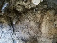
I said some time ago that he reminded me of the "Crazy Horse" memorial, and it does seem as though it may not be entirely a natural formation.
I've also explained more recently, that the Priest on the stone is apparently a composite of this one and the smaller one at the pointed end of the dagger.
I've looked for tool marks, even climbing up to the flat area in front of the face, without finding such evidence.
But the rock is very soft and can be abraded easily, so it along with everything else may have been done a long time ago.
To me it's clearly one of the inspirations for what we see carved on the stones themselves, at the very least.
So take some time and compare what can, with maybe a bit of squinting, be seen in the photo with what is carved and scratched upon the stone.
I've outlined a couple of details on the stone I'm still working with BTW.

Regards:SH.

View attachment 100_0749 BP.bmp

View attachment BW Priest 1c.bmp
 

Springfield:

Re: your post on the other topic...
Interesting, your choice of pictograph and it's similarity to the Chicomoztec depiction of the "Historia Tolteca-Chichimeca".
This is one part of the illustration which I find particularly intriguing....

View attachment sealed.bmp

I wonder who the longhairs out front are ?

The style and facial expression in this photo is uncanny.
And the cave in the background has a sealed opening in the back wall that would take dynamite to open.

View attachment comparison.bmp

The letters "MEX" are in the left side of this crop, ahead of the hunched figure at the bottom.

The sealed opening.

blocked opening.png

And the Priest in the previous photo is looking right at it !
What are the odds ?

Regards:SH.
 

Last edited:
Springfield:

Re: your post on the other topic...
Interesting, your choice of pictograph and it's similarity to the Chicomoztec depiction of the "Historia Tolteca-Chichimeca".
This is one part of the illustration which I find particularly intriguing....

View attachment 793226

I wonder who the longhairs out front are ? ...

Interesting. I was intrigued with the conversation going on between the snake priest and the bearded white guy wearing the Quetzalcoatl gear. Click to enlarge.

whiteguy.jpg
 

Last edited:
Might have something to do with the "seventh omen" to the fall of Tenochtitlan.
Look to the cave where the footsteps originate, with the firestick above.

View attachment seventh omen.bmp

I suspect the snake priest is the emissary of Moctezuma, and the Quetzalcoatl-like bearded man at the bottom is Cortez.
The upper two may be Nachan Can, a Maya ruler, and Gonzalo Guerrero, a captive spaniard who became respected Maya warrior.
Note he is wearing a breechcloth,etc. (definitely gone native) and the chieftan opposite has the Mayan facial scarring meant to imitate the jaws of the Jaguar.
Just a couple of ideas,though.

Not the example I was looking for, but it's got a great photo....Mayan Facial Scar Ritual | BME: Tattoo, Piercing and Body Modification News

Regards:SH.
 

Last edited:
True, but the Stone Maps do not.
But I am sure the placement of both the lettering relative to the Horse carving, as well as the less obvious details is very important.
The placement of the chipped area between the "COBOLLO and SANTAFE", and it's configuration for example, matches something which I have previously posted a cropped photo of. The notched area below the "bent arrow" on the lower Trail Map is another, as are the "broken" ends of the cross arms of the Stone Crosses.

Regards:SH.

Your theory regarding "who" is supported to some degree with published maps, markmar makes an important point. But your discovery location (and I am only guessing) seems to contradict these same maps. How do you reconcile that? I am not saying that you are wrong, only that this needs to be explained. That is, if the assumption is correct and if you feel inclined to do so.

Your photographs are obviously too pixel-ed to form a conclusion either way. I am looking forward to one that leaves little room for doubt.

markmar,
What do you feel are the similarities in these maps by the three families? Thanks?
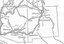
How would one have traveled from Santa Fe to Queens Creek in 1846? Which route?

Pareidolia... I have seen quite a few amazing examples of it in the Superstitions. One beautiful 60' tall carving of a Confucius like figure. But when the light shifts, the figure suddenly transforms back into a simple rock formation. In the canyons, this effect seems intensified by heat.

Here is a funny example of a fist overlooking Tortilla Flat.


Last edited:
.... How would one have traveled from Santa Fe to Queens Creek in 1846? Which route?

Pareidolia... I have seen quite a few amazing examples of it in the Superstitions. ....

They would have taken the Old Spanish Trail from Santa Fe to Zuni, where things might have been dangerous for Mexicans. Then they probably followed well-established Taos fur trapper routes down to the Salt. Below is part of a map from This Reckless Breed of Men by Robert Glass Cleland. They would have needed plenty of security and guides, IMO.

Pareidolia - a double-edged sword and a risky bet.

map sf px_0001.jpg
 

Top Member Reactions

Users who are viewing this thread

Back
Top