The "Peralta" Stone Maps --- On Their Own

These were taken from the stones that were in the Mineral and Mining Museum.

Joe Ribaudo

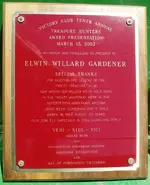
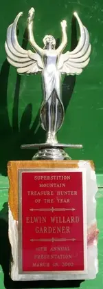
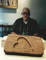
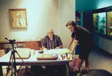
This is a photograph of my Father Elwin W. Gardner and one of my sons Ryan. This was taken about 1989 I believe. We were inside the Stone Map room at the Mineral and Mining Museum taking color and black and white photographs of the Stone Maps (over 250 photographs total). I used different lighting sources and a Canon AE-1 with a manual operating menu. My Father passed Dec. 1995 and received the "Treasure Hunters Award" posthumously in 2002. I wish that all of you could have met him.

Elwin W Garner with Heart Map-early 90's 001.jpg Elwin W-Ryan S-Trail Map-early 90's 001.jpg Elwin W Garner Dutchman Plaque & Trophy 002.JPG Elwin W Garner Dutchman Plaque & Trophy 004.JPG

I truly miss him and our times together. He rests in the desert that he loved. Veni - Vidi -Vici.


Have a great day!

Ellie Baba
 

Last edited:
Cubfan64,
Here is my understanding of where they were located. I would not be surprised to learn that it is incorrect. Somewhere between the arrows?

View attachment 788941

somehiker,
That has me scratching my head. I can not wait until the day that you lay it all out for us... your discovery. Leaves my with a few more questions, Thanks for posting that!

markmar,

Same area as myself.
The only difference of my understanding of the resting location would be under your first arrow, and the pole.
I heard they where down the bank a little.
I would say about level with the bush, under the arrow, but level with the hand rail on the bridge.
That is why what I read suggested it would be awful close to the water line at flood stage, and why would some one bury stones so close to a flood line.
They could be swept sway.
Of course lots has changed.

I am heading down to the valley this week end, I will take a pic myself.
 

Stone vs. parchment/paper?

Which do you think would be easier to recreate. A stone map with almost no way of dating, or a work on paper/parchment? Seems that even the best forger (M Hoffman) can not avoid detection with works done on paper. I would have picked stone. Carve them, drop them at a location and wait for the results. No concerns over weathering or damage. Just sit back and let the discovery happen. YES, hauling around stones is not very practical, which is another red flag.
If faked. The question would be why.
Considering the ldm legend,and the peralta legend,and all the other stories of gold in the area. Even a fake stone map could accidentally lead to a great find. Unless the person making the stones wanted everyone looking and searching for tresure in a area where there is none. Therefore keeping the correct locations un touched. If that's the case,and we throw out all the areas on the maps. What search area are left. Since i haven't been there myself. I will have to rely on others opion. So guys if the stones were deisigned to cause us to look in the wrong place. What area is left,and why.

JM,

Go East young man, go East.:hello:

Joe Ribaudo
 

If faked. The question would be why.
Considering the ldm legend,and the peralta legend,and all the other stories of gold in the area. Even a fake stone map could accidentally lead to a great find. Unless the person making the stones wanted everyone looking and searching for tresure in a area where there is none. Therefore keeping the correct locations un touched. If that's the case,and we throw out all the areas on the maps. What search area are left. Since i haven't been there myself. I will have to rely on others opion. So guys if the stones were deisigned to cause us to look in the wrong place. What area is left,and why.

Johnmark29020,
Very funny post. That was the result, many people running around, looking in many unique places. But who knows if that was intentional. I believe that a few of the symbols represented on the map lead to very specific locations in and around the Superstitions. I believe it anyway. The question is why. What did the author want us to know about these sites. What secret do they hide, if any at all.

And the maps could simply dead end. A mean joke of sorts. Remember, the number 18 does represent deceit.
Still, they do get people thinking and using their imaginations, which in and of itself is divine.

They have also destroyed a few people's lives... just to be fair.
 

Last edited:
I've grown tired of the constant rehashing of old information for the umpteenth time with folks who don't do their own research. Also gotten tired of reading so many outlandish claims of being the "sole finder" of the LDM by numerous folks every year - with absolutely no viable proof ever presented. In light of all that, I've dropped back to checking in on the forums once a month at most.

That said, I'd love to do an experiment... everyone who thinks they know (or even have heard) where the Stone Maps were found, please use a map program, do a cut and past and post here a map image of exactly where you think they were found.

I'll take a wild guess here... I bet there will only be a few that match closely.

Cubfan,

You need to get out of that lab more. An experiment? You are going to do an experiment with us dutch hunters now? ??? Is there any cheese involved?

Will the results of this experiment reveal the place where the PSM's were really found, or will it just put us in separate groups? Just place me in group A.

Homar
 

Who cut the cheese? Anyone else aware of this fact? N/E end of runway almost points to where the Stone Maps were found...weird huh?

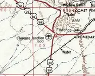
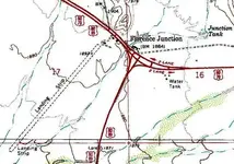
Florence Junction Airport (1[SUP]st[/SUP] location), Florence Junction, AZ

33.25 North / 111.35 West (Southeast of Phoenix, AZ)


1954 Florence Junction Topo Map.png FlorenceJunction-airport- New Highway_AZ-topo2.jpg


The original location of Florence Junction Airport, as depicted on the 1954 USGS topo map.
Photo of the airport while in use has not been located.
The original Florence Junction Airport was evidently established at some point between 1950-52,
as it was not yet listed among active airfields in the 1945 AAF Airfield Directory (courtesy of Scott Murdock)
nor depicted on the 1950 Gila River World Aeronautical Chart (according to David Brooks).
The earliest depiction which has been located of the Florence Junction Airport
was on the 1952 Phoenix Sectional Chart (according to David Brooks),
which described the field as having a 5,200' dirt runway.
The 1954 USGS topo map depicted the Florence Junction Airport to the southwest of the crossroads.

DOC Bulletin 2
1931
Florence Municipal
C
Florence
AF
32-58-42
32.978333
111-21-30
-111.358333
1,500
Dirt
all way
2,200
2200x1700; 4.5 miles south of town
AvWeek Dir.
1957
Florence Municipal
C
Florence
AF
32-58-42
32.978333
111-21-30
-111.358333
1,500
Dirt
1
3,600
(E); 3.4 miles SSE. Not on 1957 Phoenix SAC. No remains
PH SAC Q-3
1952
Florence Junction
C
Florence Junction
AF
33-15-25
33.256944
111-20-37
-111.343611
1,900
Dirt
1
5,200
Not on 1950 Gila River WAC 405
PH SAC Q-3
1955
Florence Junction
C
Florence Junction
AF
33-15-25
33.256944
111-20-37
-111.343611
1,900
Turf
1
3,200
Not on 1957 Phoenix SAC. Yet there are listings in directories till 1968. Was it closed or uncharted?
AOPA Directory
1968
Florence Junction
C
Florence Junction
AF
33-15-25
33.256944
111-20-37
-111.343611
1,900
Dirt
1
5,000
(2/20); adjacent to town
USGS/NAPP
1992
Unknown 1 - Florence Junction AZ
?
Florence Junction
U
33-15-33.5
33.259306
111-19-44.6
-111.329056
1,900
Hard
1
3,400
Not on 1990 USGS topo.
Google Earth
Current
Unknown 1 - Florence Junction AZ
?
Florence Junction
U
33-15-33.5
33.259306
111-19-44.6
-111.329056
1,900
Hard
1
3,400
8/26 orientation. Google Earth picture is low resolution but you can see it is there. On east side of Florence Junction. Most of the runway appears to be asphalt and some dirt/gravel on the west end of the runway. Not charted and unlisted.

If the Stone Maps were found in 1949 as some believe is it possible the runway was there at that time?

Ellie Baba
 

Last edited:
Cubfan,

You need to get out of that lab more. An experiment? You are going to do an experiment with us dutch hunters now? ??? Is there any cheese involved?

Will the results of this experiment reveal the place where the PSM's were really found, or will it just put us in separate groups? Just place me in group A.

Homar

Cubfan

You mean you did'nt believe me! It must be that time of the month again.

Best to ya , Wrmickel1
 

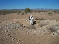
G/E view of area where Stone Maps found in 1948/9.
1....small hill where H/P Stone found......cut down by highway crew in 2011 and incorporated in new levee built along top of embankment.
1b...east side of cattle trail where Trail Map Stones found
2-5...additional old excavations ...gps co-ordinates by Cubfan

View attachment Tumlinson Discovery Area.bmp

Cubfan in one of the excavations...

100_0971.png

Regards:SH
 

Last edited:
Who cut the cheese? Anyone else aware of this fact? N/E end of runway almost points to where the Stone Maps were found...weird huh?

Florence Junction Airport (1[SUP]st[/SUP] location), Florence Junction, AZ

33.25 North / 111.35 West (Southeast of Phoenix, AZ)


View attachment 789164 View attachment 789165


The original location of Florence Junction Airport, as depicted on the 1954 USGS topo map.
Photo of the airport while in use has not been located.
The original Florence Junction Airport was evidently established at some point between 1950-52,
as it was not yet listed among active airfields in the 1945 AAF Airfield Directory (courtesy of Scott Murdock)
nor depicted on the 1950 Gila River World Aeronautical Chart (according to David Brooks).
The earliest depiction which has been located of the Florence Junction Airport
was on the 1952 Phoenix Sectional Chart (according to David Brooks),
which described the field as having a 5,200' dirt runway.
The 1954 USGS topo map depicted the Florence Junction Airport to the southwest of the crossroads.

DOC Bulletin 21931Florence MunicipalCFlorenceAF32-58-4232.978333111-21-30-111.3583331,500Dirtall way2,2002200x1700; 4.5 miles south of town
AvWeek Dir.1957Florence MunicipalCFlorenceAF32-58-4232.978333111-21-30-111.3583331,500Dirt13,600(E); 3.4 miles SSE. Not on 1957 Phoenix SAC. No remains
PH SAC Q-31952Florence JunctionCFlorence JunctionAF33-15-2533.256944111-20-37-111.3436111,900Dirt15,200Not on 1950 Gila River WAC 405
PH SAC Q-31955Florence JunctionCFlorence JunctionAF33-15-2533.256944111-20-37-111.3436111,900Turf13,200Not on 1957 Phoenix SAC. Yet there are listings in directories till 1968. Was it closed or uncharted?
AOPA Directory1968Florence JunctionCFlorence JunctionAF33-15-2533.256944111-20-37-111.3436111,900Dirt15,000(2/20); adjacent to town
USGS/NAPP1992Unknown 1 - Florence Junction AZ?Florence JunctionU33-15-33.533.259306111-19-44.6-111.3290561,900Hard13,400Not on 1990 USGS topo.
Google EarthCurrentUnknown 1 - Florence Junction AZ?Florence JunctionU33-15-33.533.259306111-19-44.6-111.3290561,900Hard13,4008/26 orientation. Google Earth picture is low resolution but you can see it is there. On east side of Florence Junction. Most of the runway appears to be asphalt and some dirt/gravel on the west end of the runway. Not charted and unlisted.

If the Stone Maps were found in 1949 as some believe is it possible the runway was there at that time?

Ellie Baba
Ellie,
I think that the airport is just south of the discovery site. I think.

I am not sure that this is the same location, but if it is, this is how Tumlinson would have seen it. Can anyone tell if this picture is correctly labeled?
Everyone. PLEASE read the footnote. When did Travis discover the stones? Very convenient location. I am still trying to remember where I read the story of the stones being purchased from a construction worker???

Images of the site under construction: http://azmemory.azlibrary.gov/cdm/search/collection/histphotos/searchterm/queen creek/order/nosort
View attachment 789349
 

Last edited:
Stone vs. parchment/paper?

Which do you think would be easier to recreate. A stone map with almost no way of dating, or a work on paper/parchment? Seems that even the best forger (example:M Hoffman) could not avoid detection with works done on paper. I would have picked stone. Carve them, drop them at a location and wait for the results. No concerns over weathering or damage. Just sit back and let the discovery happen. YES, hauling around stones is not very practical, which is another red flag.

Not a red flag at all Hal.
A false flag perhaps.
There is nothing on the Stones which cannot be copied onto a piece of paper or parchment and carried in a shirt pocket.
Once in possession of the more durable stones, replacement paper (or in our case, photos) can be made as may become necessary.

Regards:SH.
 

somehiker,
If they were intentionally buried, there is little chance that one worked its way to the surface. If they were dropped in place, there would most certainly have been some other object found along side the stones. A clasp, material fibers, anything (or part) that may have held the stones. There is no report of Travis finding anything else... in the discovery site. So, one was left, protruding from the ground. That is the tell.

It seems that Travis may have crossed the new bridge if the discovery year was 1948.
 

Last edited:
Hal:

The photo you posted is of the other bridge, which is further upstream on QC. Some have claimed the stones were found there.
Tumlinson found the H/P stone first, sticking out of the side of a small hill. He said that one corner was exposed and he tripped on it while climbing the hill.
He thought it was a brick at first, but noticed markings, so he dug it out of the dirt.
I believe that pile of dirt, originally about 7-8 ft. high, was left over from grading the approach ( and drainage ditch) to the re-constructed bridge.
An excavator operator may have excavated the stone, along with the dirt, which later was partly exposed by wind or rain.
Seems clear that the stones were not dropped in place, but that they were deliberately buried for safekeeping.
There may have been no reason to leave anything else in the same holes as the stones themselves were placed.

Regards:SH.
 

Last edited:
johnmark,

Interesting that I saw you had posted something on this thread. Well I started reading the older posts relating to the Stone Maps and I realized that some questions had not been answered.

1. Why is the heart insert stone red in color; it represents the blood of Christ and the price he paid for our sins. The Sacred Heart Church is a major clue and the Jesuits are involved. Joe is absolutely correct regarding the type of lighting used to take photographs of the Stone Maps.

2. The heart was cracked/broken separating the upper left lobe; it is a death sign warning the uninitiated to stay away or die.

3. There are three hearts displayed on the heart map, one under the heart insert and one on each side of the insert.

4. There are three hearts located adjacent to each other at a specific location in the depository area defined by the horse map.

5. The horse of the Holy Faith (a large monument enhanced by the hands of man) directs us to the fourth stone map found near the three hearts; it is known as the "R- rock". The horse stone map directs us where to find the "Horse of the Holy Faith monument". The McGee's million $ horse truly exists.

6. The R-rock monument is required in order to solve many of the clues found on the Stone Maps; primarily the Horse Tablet.

My new book is currently being edited; it will not be too soon for me.

Have a great week!

Ellie B

May I ask where the sacred heart church is located?good luck
TOM
 

somehiker,
The grandson of a remembered treasure hunter stops at a newly constructed overpass, for a better view of Weavers Needle, and accidentally finds a group of stones carved in the system of treasure symbols. I just find it hard to believe that someone taking the pains to bury the stones for "safekeeping" would have done so, so carelessly. That site was busy for months with construction workers, surveyors, and officials with the Highway Department. And no one noticed what Travis had found? A brick like object protruding from the ground would have caught someones eye. Don't you think?

You are correct. If they were intentionally placed and not meant to be found I would not expect to find anything else.
It does sound as if you believe the stones to be significant and much older than the 1940's?
I wish that were true.
 

Somehiker,

I have always wanted to ask you about the changes on the holes where the PSM's were found.

On your initial investigation, you posted a view of the area on thelostdutchmangoldmine forums showing just five excavations. This was posted in 2010. Later after Paul went and got gps readings, you posted here on TreasureNet an other view or image of the area with more holes, and what I assume, a correction of the holes locations.

The holes marked 1, and 1b, are too close to the road for you or anyone else to have missed them on the initial search. They are also too close to the road to have been miss spotted on the first image. Didn't it occur to you that this are new holes that were not there before 2010?

I know that you like others have fallen for some of the stories that keep getting fabricated, not hard due to more lies than facts floating around. What I have noticed is that you are more open minded than most around here, and are able to readjust your thinking when something more solid appears before you.

It is my belief that you or Paul have made a mistake labeling holes 1, and 1b as the original excavation made by Travis.

I would say that the hole marked as hole number 5 on the corrected image would be the original.

Homar P. Olivarez
 

Hal:

The photo you posted is of the other bridge, which is further upstream on QC. Some have claimed the stones were found there.
Tumlinson found the H/P stone first, sticking out of the side of a small hill. He said that one corner was exposed and he tripped on it while climbing the hill.
He thought it was a brick at first, but noticed markings, so he dug it out of the dirt.
I believe that pile of dirt, originally about 7-8 ft. high, was left over from grading the approach ( and drainage ditch) to the re-constructed bridge.
An excavator operator may have excavated the stone, along with the dirt, which later was partly exposed by wind or rain.
Seems clear that the stones were not dropped in place, but that they were deliberately buried for safekeeping.
There may have been no reason to leave anything else in the same holes as the stones themselves were placed.

Regards:SH.

Hello my friend , it doesnt matter what stone and the holes.they are all related.the map you have of all the gold mines,(Spanish map) is also part of it.crosses,hearts ,Latin hearts are all in the mix but there are distances in between.
You'd should join me on my next trip.
TOM
 

Hal

You wrote " I am still trying to remember where I read the story of the stones being purchased from a construction worker "

Maybe at superstitionmountaintomkollenborn.blogspot.com/2009/07/peralta-stone-maps-part-1.html ( copy/paste ) .

Marius
 

Top Member Reactions

Users who are viewing this thread

Back
Top