The "Peralta" Stone Maps --- On Their Own

It is key to find the hidden heart. once u understand what the dagger represents. u would find the map is a double map it has to be turned upside down to find the hidden heart. both mines have a significance to the recovery of gold. Hint Hint.

The dagger area is just north of the state park (there you go Bill Riley, Dagger stone was just north of park, I have a picture of it somewhere). Heart area is just west of the state park. Cross area is in the state park, per carvings in saguaros & boulders, from my years of being out there.
 

Last edited:
Lordy........I all ready told you......many folks make it far more difficult than it is.

The maps already tells you everything you need to know. Its written on them. They were some smart guys that put it on them.

This isn't my original concept. Jim Hatt got pretty far along in this theory before he ventured off. As did Kesselring. Hatt dated the maps to the spring of 1767. I think he's hitting pretty close with that date, give or take 10 years or so. IMO, both of them got off track by not differentiating between the sun symbol (dot in a circle) and a mine.

All you have to do is take direction the original map makers already told you and find Polaris against the horizon and find your eastern cardinal point (which also is already on the map); get yourself headed in the right direction and then follow the survey map they laid out for you.

As to how smart those guys were ......I'd say they knew a thing or too.

As to what they knew.........bear with me a minute. This video is pretty dry but it will give you an idea of how its done. Stay with him through the 3D model of the earth, the sun, and the changing angles. The rest just hurts my head. But it gives you a pretty good idea of the concept.


Bottom left is right........don't know about the other two.
 

Top pic is my dad (in black) , just came to AZ from Texas with a friend in my dad's Buick.
 

It was the KGC. Jesse James's grandson. They are still there watching the mine, ready to kill anyone that gets close. Did you know that Brigham Young put Hitler's personal Volkswagon in the Lue Mine and hid the Golden Mormon Plates in the glove box, just one chamber over from where the Arc is? You didn't know that! Does anyone around here ever solve a treasure mystery? You could put up an anonymous video. By the way, i was born in Phoenix in 56, my mom was born in Buckeye much earlier, and my Grand Parents are documented Pioneers of Arizona. I think I got a handle on it. So thank you azdave35 and some hiker for the great information. So tell me, which treasures have you two solved lately? Put up an anonymous video and show us how rich you are. I am bored with this!
 

It was the KGC. Jesse James's grandson. They are still there watching the mine, ready to kill anyone that gets close. Did you know that Brigham Young put Hitler's personal Volkswagon in the Lue Mine and hid the Golden Mormon Plates in the glove box, just one chamber over from where the Arc is? You didn't know that! Does anyone around here ever solve a treasure mystery? You could put up an anonymous video. By the way, i was born in Phoenix in 56, my mom was born in Buckeye much earlier, and my Grand Parents are documented Pioneers of Arizona. I think I got a handle on it. So thank you azdave35 and some hiker for the great information. So tell me, which treasures have you two solved lately? Put up an anonymous video and show us how rich you are. I am bored with this!

being as how bringham young died in 1877 i doubt he put anything in hitlers vw....
 

It was the KGC. Jesse James's grandson. They are still there watching the mine, ready to kill anyone that gets close. Did you know that Brigham Young put Hitler's personal Volkswagon in the Lue Mine and hid the Golden Mormon Plates in the glove box, just one chamber over from where the Arc is? You didn't know that! Does anyone around here ever solve a treasure mystery? You could put up an anonymous video. By the way, i was born in Phoenix in 56, my mom was born in Buckeye much earlier, and my Grand Parents are documented Pioneers of Arizona. I think I got a handle on it. So thank you azdave35 and some hiker for the great information. So tell me, which treasures have you two solved lately? Put up an anonymous video and show us how rich you are. I am bored with this!

Lately.....you mean last month ?
We/I have solved the hardest one of all. So big that it doesn't even have a name.....yet.
I used a top secret camera that my contacts at the CIA loaned me. It sees right through mountains, so you don't need a pick or shovel, or even one of them stone star maps to find anything anymore. The pictures from that camera are all the proof we need.
I would put up the pictures AND a video, but my partner Anonymous, the video director, thinks the Illuminati would then be able to find it, cause them guys are pretty smart.....so I can't. You should just believe me anyway.
We are writing a book about all of our adventures. But only to "throw people off", about the real story and place where we found it.
 

Last edited:
Top pic is my dad (in black) , just came to AZ from Texas with a friend in my dad's Buick.

Carrol, I was wondering if you were going to post those pics...when are you going to publish your Dad's notes, hint hint...

BTW, there's a real good place on the side of RT 66 in Ash Fork (on the way from PHX to Oregon back in the day) where you can pull off the side of the road, take a break, and fill your trunk with lots of Coconino whatchacallit stone if someone had a dremel in their holster and had a habit of doodling on rocks...just sayin....

Lordy........I all ready told you......many folks make it far more difficult than it is.

..............SNIP.......................
All you have to do is take direction the original map makers already told you and find Polaris against the horizon and find your eastern cardinal point
..............SNIP.......................

Thanks Lynda, I knew I had to be over-thinking it...at first I thought you meant they were taking cocked hats (triangulating ) stars at every dot....after I thought about it for awhile, I had already figured out it must have been Polaris they were looking at based on your comment that latitude of the star was unimportant (EDIT: changes in latitude over time were not so important because of the short time frame involved...and no mention or concern about RA...there is only one star in the northern hemisphere that would apply to) so thanks for hanging in there and pounding until I finally got the concept...take care, Jim
 

Last edited:
Lordy........I all ready told you......many folks make it far more difficult than it is.

The maps already tells you everything you need to know. Its written on them. They were some smart guys that put it on them.

This isn't my original concept. Jim Hatt got pretty far along in this theory before he ventured off. As did Kesselring. Hatt dated the maps to the spring of 1767. I think he's hitting pretty close with that date, give or take 10 years or so. IMO, both of them got off track by not differentiating between the sun symbol (dot in a circle) and a mine.

All you have to do is take direction the original map makers already told you and find Polaris against the horizon and find your eastern cardinal point (which also is already on the map); get yourself headed in the right direction and then follow the survey map they laid out for you.

As to how smart those guys were ......I'd say they knew a thing or too.

As to what they knew.........bear with me a minute. This video is pretty dry but it will give you an idea of how its done. Stay with him through the 3D model of the earth, the sun, and the changing angles. The rest just hurts my head. But it gives you a pretty good idea of the concept.

You are confusing Jim Hatt with Rex Western (a.k.a. maptech) who is the person that came up with the theory that 8-N-P was an isogonic drift deviance that would be required in order to make the theory that the TS were some sort of navigational map, feasible.

The only reason Jim went through with all those navigational exercises, especially with the 1847, was to try to make sense of it, for himself. He didn't have any set theory about the Stone Maps. He was a man who kept many of his cards very close to his chest.

He did get one thing right- that you cannot get anywhere with the Stone Maps if you don't make use of all of them, including the Stone Crosses, the LH (the cursum perficio is a sort of cheat sheet). Although the H/P stone and the TS stones could conceivably stand by themselves (and the designer of these maps did design them that way, in case the stones got separated, or lost), the degree of difficulty is compounded pretty fast.
 

Last edited:
You are confusing Jim Hatt with Rex Western (a.k.a. maptech) who is the person that came up with the theory that 8-N-P was an isogonic drift deviance that would be required in order to make the theory that the TS were some sort of navigational map, feasible.

The only reason Jim went through with all those navigational exercises, especially with the 1847, was to try to make sense of it, for himself. He didn't have any set theory about the Stone Maps. He was a man who kept many of his cards very close to his chest.

He did get one thing right- that you cannot get anywhere with the Stone Maps if you don't make use of all of them, including the Stone Crosses, the LH (the cursum perficio is a sort of cheat sheet). Although the H/P stone and the TS stones could conceivably stand by themselves (and the designer of these maps did design them that way, in case the stones got separated, or lost), the degree of difficulty is compounded pretty fast.


You are right the trail map and the stone cross can be figured out , but The H/p map is the key for the rest once u figure that one out the hidden heart and the latin heart are able to be figured out.
 

Jim and my friend Real, please tell me you guys are spoofing me. Our US Navy is better at navigating than being lost at a quarter NM. Please tell me I misunderstood that <g>. I've been doing that a lot lately.

Surveying and ocean navigation are ancient skills. I'm not going to tell you I can do the math, math ain't my thing, but I understand the concept enough to get by and follow directions.

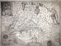
Capt. John Smith's map of Virginia (land and sea) made circa 1612 is still good today. Longitude wasn't a settled issue in his time but the concept was there even if the beginning point wasn't constant among map makers. I could use his map, sail a boat into Chesapeake Bay, follow the James River to its junction of the Chickahominy and take a compass bearing to my home door right off that map and be home in time for dinner. Its that accurate in scale and detail. And; we are talking 1612. Give the "smart guys" a hundred and 50 years to perfect their skills and just think how much more accurate they would be.

Here's his map........North to the right

image.jpg
 

I don't think my link worked. Here's the ULR to the presentation............. www.youtube.com/watch?v=v6_lrjyRkUM

Your link worked on my screen - I wonder if you have a setting or are using a web browser that doesn't support those video links which might explain why you didn't see the video link in the other post we were talking about yesterday. Here's a screen shot of what shows up for me...
Lynda.JPG
 

Most be a change that happened in a system update. I'm computer illiterate in fixing those issues. I'll have to call the help desk on this one...........
 

Jim and my friend Real, please tell me you guys are spoofing me. Our US Navy is better at navigating than being lost at a quarter NM. Please tell me I misunderstood that <g>. I've been doing that a lot lately.

Real will probably be a lot better at answering this, as in my day we used electronic navigation aids and really didn't have to use celestial navigation...but the Navy still wanted some of our Sailors onboard to be able to do it, at least they did about 20 yrs ago while I was involved...

First, there's a difference between brown-water navigation and blue-water navigation...if you're within sight of land, you got no real problems. Now taking an aircraft carrier out of Norfolk and arriving within sight of port, say on the coast of Portugal, using celestial navigation, that's something else entirely...keep in mind that a warship is always steaming, sometimes quite quickly and not in a straight line and never at a constant speed...so forget dead reckoning...you're moving while you're trying to sight stars...for example, we have to keep the pointy end into the wind on a carrier if we're launching/recovering aircraft, so the helm is always making adjustments to course also...now take into account currents...how far and how inconsistently they will push you off course...now take into account wind blowing against the big old pig at say 20 kts, changing direction constantly, the hull of a ship acts like a big sail and wind will keep pushing you off course to God knows where...now try to take those sightings while the ship is rolling in swells...and it takes you 3 or 4 days to cross the ocean...well, to drop the hook within sight of the port you intended to call after all that, yes, our Navy could and probably still can do that...but it ain't as easy as one would think if all you have is a bobbing, moving platform with nothing in sight but sun, moon and stars and your trusty chronometer...

Surveying on land...yup, those guys are probably a lot better since they're stationary and have landmarks to check against...but other than understanding how to work a sextant, land surveying is foreign to me, which is why I tried to apply my seagoing navigation to something related to surveying...your use of the term "declination" indicated to me someone was using celestial navigation, so I got all tangled up.
 

Looking at the photo of the stones on the front bumper of the Olds, it looks like there`s some markings that are not on the stones in the museum. To the left of the heart under the knife.
 

Hey Jim, I never said it was easy<g>. Might be easy for the geometry wizards, but not for me. But; (there goes that word..) If a fellow can find Polaris and find Orion's leading star in the east as it rises, and.... here's the hard part....that fellow can calculate the deviation from the heading he was "supposed to be on" it goes a long ways in being able to right your course. How far you have come is a different matter. The smart folks can make that calculation, not me, that's out of my league.
 

Last edited:

Top Member Reactions

Users who are viewing this thread

Latest Discussions

Back
Top