The "Peralta" Stone Maps --- On Their Own

The Peralta Stones were fabricated by some rich business owners in AJ to create a storm of tourism. Isn't the discovery story fishy enough?

lol..in 1950 there were only about 3 business's in apache junction...which one of these multi millionaires do you suspect?
 

Dave is right, Holyground.
The growth of Apache Junction is due to the popularity of the Phoenix area overall, for many reasons having nothing to do with the treasure legends which we discuss on here.
The Superstitions, the lakes, and the Apache Trail draw far more visitors by the scenery alone, than the LDM and Stone Maps ever did or will in the future. Even most of these will never venture farther in to the mountains than Tortilla Flat, where after a burger, a beer, and perhaps the purchase of a tee shirt, will turn their wheels around and make their way back to wherever they live and work from Monday-Friday. Only a few will ever give a rat's patootie for what turns our crank.
 

Last edited:
In my opinion…….take it for what its worth……….

Most of you are trying too hard. The stones are much more straight forward than what you are making them out to be.

I’ll let you figure out which is which, but I will share this thought with you. There are two different types of charts in the set.

The first and the most important is the general survey map. And; its not too different than survey maps today. You use a series of constants to orientate yourself to your target area. They are all shown on this map, along with the tools to gauge them shown in charactery.

What you are calling “mines” on that chart are not mines at all. They are points of declination. Date and time makes a difference. With only a slight wobble, this pattern of declination is repeated over and over as the earth rotates. Not only are they shown and mapped, they are spelled out for you. Without knowing the exact date, using those constant cardinals in the night sky will get you close. You can further refine using time charts and dates of return. But its not critical to getting you to the right area.

Further; some (not all) of what you are calling a river isn’t a river. It’s the horizon in your field of view.

Once orientated to the area, you have a much more detailed “survey” of the travel route in the companion maps. However; the original cardinal points (with declination) and horizon are superimposed on those maps so you can check yourself along the way.

Check it out for yourself. Their placement isn't by accident.

Lyn
 

Last edited:
Lynda

What the Horse " says " how is grazind north of the River ( horizon ) is true . So , the horizon is to the south of the horse , and your opinion how the 5 dots is Ursa Major is wrong IMO and logically .
 

What makes you think my opinion has anything to do with Ursa Major?? If I was pulling coordinates off Ursa Major I'd be looking somewhere near San Pablo, LOL

Edit: Actually; I'd be bobbing around in the Pacific but to keep it on terra firma I'll stick with San Pablo. More like where I'd wash up.
 

Last edited:
IMO , the stone maps haven't any star chart for orientation . They have only landmarks because are for a very small region .
When you are on the Trail , the Horse isn't in sight . After you have recognized what is the " R " , then you can find where the Horse is ( for the mines ) because " RIO " is in the same place with the " R " . The " R " line is half of the " RIO " line .
 

In my opinion…….take it for what its worth……….

Most of you are trying too hard. The stones are much more straight forward than what you are making them out to be.

I’ll let you figure out which is which, but I will share this thought with you. There are two different types of charts in the set.

The first and the most important is the general survey map. And; its not too different than survey maps today. You use a series of constants to orientate yourself to your target area. They are all shown on this map, along with the tools to gauge them shown in charactery.

What you are calling “mines” on that chart are not mines at all. They are points of declination. Date and time makes a difference. With only a slight wobble, this pattern of declination is repeated over and over as the earth rotates. Not only are they shown and mapped, they are spelled out for you. Without knowing the exact date, using those constant cardinals in the night sky will get you close. You can further refine using time charts and dates of return. But its not critical to getting you to the right area.

Further; some (not all) of what you are calling a river isn’t a river. It’s the horizon in your field of view.

Once orientated to the area, you have a much more detailed “survey” of the travel route in the companion maps. However; the original cardinal points (with declination) and horizon are superimposed on those maps so you can check yourself along the way.

Check it out for yourself. Their placement isn't by accident.

Lyn

Hey Lynda,

Very interesting...I will leave the interpretation of treasure symbols and maps to people on here that know what they're talking about because I certainly don't...the only thing I would add is that if we are talking celestial navigation, it's not just declination that will change.

For example, if you go to a certain spot on say July 1st of every year, and sight a star, it's declination ("latitude" in relation to the celestial equator) will change as you said, but it's right ascension ("longitude") will change slightly as well...so there has to be more than just an angle from the horizon at a certain date and time, or the map won't be very good for anything...maybe I'm not getting what you're talking about, but the pattern you referred to "repeating over and over" actually repeats only every 25,000 or so years...not every year...(and that's not even a given due to gravitational effects on the earth's axis due to other planets, etc, but it is generally true).

Granted this change occurs very slowly, is there anything on the PSM's that account for this? Take care, Jim
 

Latitude isn't going to change. At least not in any measurable significance for our discussion. Longitude was the cat that had to be skinned and that's what the dots are all about. Time, distance and angle.
 

Hey Lynda,

Very interesting...I will leave the interpretation of treasure symbols and maps to people on here that know what they're talking about because I certainly don't...the only thing I would add is that if we are talking celestial navigation, it's not just declination that will change.

For example, if you go to a certain spot on say July 1st of every year, and sight a star, it's declination ("latitude" in relation to the celestial equator) will change as you said, but it's right ascension ("longitude") will change slightly as well...so there has to be more than just an angle from the horizon at a certain date and time, or the map won't be very good for anything...maybe I'm not getting what you're talking about, but the pattern you referred to "repeating over and over" actually repeats only every 25,000 or so years...not every year...(and that's not even a given due to gravitational effects on the earth's axis due to other planets, etc, but it is generally true).

Granted this change occurs very slowly, is there anything on the PSM's that account for this? Take care, Jim

jim...if those stone maps are real (and i dont think they are)..they would have been created so the man who made the map could return within a year or so...i dont think those people cared if someone 200 years later came along to find the treasure...in other words..anyone that makes a map to a treasure is making it so they can return to the site...not for treasure hunters of the future
 

jim...if those stone maps are real (and i dont think they are)..they would have been created so the man who made the map could return within a year or so...i dont think those people cared if someone 200 years later came along to find the treasure...in other words..anyone that makes a map to a treasure is making it so they can return to the site...not for treasure hunters of the future

Definitely not an one-man operation.

And based on how the signs were left, and what they were left on, they were definitely thinking long term.
 

Definitely not an one-man operation.

And based on how the signs were left, and what they were left on, they were definitely thinking long term.

of course it wasn't a one man operation ...probably a two or three man operation with a bunch of peons for labor....and most of the signs you see on rocks out there were put there by indians or treasure hunters in the 20th century...and i dont believe they were thinking long term...they knew their days were numbered up here because whitey was slowly but surely taking over...if they did make maps it was for them so they could go back...or possibly for their family if they got scalped and didn't make it back:occasion14:
 

Hey Dave,

IMO, the maps are real. At least the original ones are <g>. Its the stories around them that get fuzzy.

PS: I don't know why the angry face is in the header on this post. Gremlins~~
 

Last edited:
Maps to what though ?
Even IF genuine, there is nothing on the so-called "Peralta" stones about their purpose.... be it mines and/or a treasure cache(s).
So perhaps it's something else entirely ?
Only the Stone Cross set and Cursum Perficio drawing mention a "Treasure of the Church of the Holy Faith".
And the "upper trail stone" does have a tracing of one of the stone crosses on the reverse, which implies that a connection between the two sets of stones is possible.

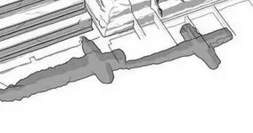
Here's a depiction of a more recently revealed man-made tunnel in the shape of two crosses that I am interested in, for a number of reasons.........
....one being that it was found to contain various artifacts..... IOW... "treasures" of another "Santa Fe", including a large quantity of liquid mercury.

tunnel under temple of the plumed serpent at teotehuacan cr.jpg
https://www.smithsonianmag.com/hist...mexico-solve-mysteries-teotihuacan-180959070/
https://www.scientificamerican.com/article/new-artifact-filled-chambers-revealed-under-teotihuacan/

see also.....https://www.sciencealert.com/archae...l-hidden-beneath-mexico-s-pyramid-of-the-moon

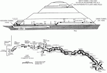
"The tunnel under the Pyramid of the Sun was found in the 1970s but had been looted centuries before, so experts are hoping this one might have more secrets to reveal, if we ever get down to it."

Pyramid of the Sun cave.gif
 

Last edited:
Maps to what though ?
Even IF genuine, there is nothing on the so-called "Peralta" stones about their purpose.... be it mines and/or a treasure cache(s).
So perhaps it's something else entirely ?
Only the Stone Cross set and Cursum Perficio drawing mention a "Treasure of the Church of the Holy Faith".
And the "upper trail stone" does have a tracing of one of the stone crosses on the reverse, which implies that a connection between the two sets of stones is possible.

Here's a depiction of a more recently revealed man-made tunnel in the shape of two crosses that I am interested in, for a number of reasons.........
....one being that it was found to contain various artifacts..... IOW... "treasures" of another "Santa Fe", including a large quantity of liquid mercury.

View attachment 1607532
https://www.smithsonianmag.com/hist...mexico-solve-mysteries-teotihuacan-180959070/
https://www.scientificamerican.com/article/new-artifact-filled-chambers-revealed-under-teotihuacan/

see also.....https://www.sciencealert.com/archae...l-hidden-beneath-mexico-s-pyramid-of-the-moon

"The tunnel under the Pyramid of the Sun was found in the 1970s but had been looted centuries before, so experts are hoping this one might have more secrets to reveal, if we ever get down to it."

View attachment 1607548

I was fortunate to have visited Teotihuacan a couple years ago while they were excavating under the Feathered Serpent pyramid. The mercury found was a series of small puddles within a sort of a diorama depicting lakes or other bodies of water in some undefined setting - or so the buzz was there at the time. The "large quantity" tag was apparently a media hook.

Some Mesoamericans used the cross symbology, but in these tunnels, it seems like the "arms" are only convenient alcoves off to the sides where the artifacts were stashed. Haven't heard any more about this project since. In any event, don't pass up an opportunity to visit this site if you get a chance. Spoiler: prepare for an onslaught of pests selling rugs, jewelry, et al, everywhere you go there. Detracts from the ambiance.
 

The actual volume of mercury might not be large by industrial standards, but I suspect for most people, including the media, anything more than they are familiar with, would be "large". I have experienced what you speak of, including the annoying and time consuming, but necessary, haggling whenever I have seen something I was interested in.
 

Last edited:
Latitude isn't going to change. At least not in any measurable significance for our discussion. Longitude was the cat that had to be skinned and that's what the dots are all about. Time, distance and angle.

OK....I think I get it now...


jim...if those stone maps are real (and i dont think they are)..they would have been created so the man who made the map could return within a year or so...i dont think those people cared if someone 200 years later came along to find the treasure...in other words..anyone that makes a map to a treasure is making it so they can return to the site...not for treasure hunters of the future

True, if I hid a treasure and had to make a map, I would make dang sure nobody could easily figure it out without knowing something ONLY I KNOW...

Dave, if I had to place a bet on how the stone maps originated, I would have to lay my money on Travis Tumlinson carving them...that's just my conclusion by reading (most) of the posts on here and elsewhere, and that's the extent of my knowledge or interest...just basing it on what people have written, reading the stories of all the people who claimed to have found them, other people's research and talking to the family, etc., and what I personally think makes the most sense after digesting all of that...but I have no first hand knowledge or study of them, so I will always keep an open mind on the whole thing, as there's no possible way I could know the truth of it based on the little I've read about them...

The stone crosses, I have no idea, not even sure what they are...saw some pics of them, or copies of them, once or twice...no real interest for me...But the stone maps, while I think it's most likely T.T. made them, I have no idea why he carved them... if he copied them from something else, etc. Yo no se. Whether they lead to anything I have no idea, but would really like to see someone who HAS put a lot of time into the subject find a big ol' treasure with them...
 

Some Mesoamericans used the cross symbology, but in these tunnels, it seems like the "arms" are only convenient alcoves off to the sides where the artifacts were stashed.

I take it then, that you see no possibility of a connection between the configuration of the two connected tunnels, where both upper and lower chambers are laid out in very similar proportion to the stone crosses. That such an extensive undertaking was only done out of convenience ?
What about the other tunnel, with it's series of radial alcoves at the end of the passage, as well as the two opposing alcoves nearer the entrance ?
 

of course it wasn't a one man operation ...probably a two or three man operation with a bunch of peons for labor....and most of the signs you see on rocks out there were put there by indians or treasure hunters in the 20th century...and i dont believe they were thinking long term...they knew their days were numbered up here because whitey was slowly but surely taking over...if they did make maps it was for them so they could go back...or possibly for their family if they got scalped and didn't make it back:occasion14:

The signs that I have seen were not in a convenient area- up high and in a very isolated place. In all the time I've spent there, I've never run into anyone. Only once did I see a person, and that was a hunter who was just as surprised to see me, as I was him, and even then that was just on my way in, barely halfway. Considering the size of some of the signs, their placements (some on dangerous cliffs) the elaborate arrangements and relationships they have with one another, this was much more than an enterprise of just a few people, and certainly much older than when "whitey" first came onto the scene, because of how weathered they are- severely weathered to the point of pretty much disappearing into the rocks.
 

Last edited:
Wayne, you have provided excellent information and often up close valuable pictures of areas of interest. Its much appreciated and provides valuable insight. You deserve every accolade and praise for that.

Having genuinely commended you on that.........I find it ironic that somehow you are so angry, jealous, hurt??? (something?) that you won't even give credit to Ryan for the quality of his voice. That takes away from your credibility which is otherwise impeccable. Its petty.

You know darn well that's Ryan's voice. He shot the film, wrote the dialog, edited it, and produced the final. It involved a lot of work on Frank's part and Ryan's. It takes nothing away from you. It was produced with a lot of work and skill and freely provided for all to enjoy. Take it or leave it. It doesn't harm you in any way.

We all have faults and are imperfect. He may be a lot of things (as we all are) but untalented isn't one of them. Why can't you just enjoy the footage and overcome the urge to tear someone down for no reason.
 

Top Member Reactions

Users who are viewing this thread

Back
Top