Presently, it looks like the storm may not reach hurricane status after all, though interests in the area should continue to monitor its passage. "A decrease in forward speed and a sharp turn to the north and northeast is expected Monday night and Tuesday," the U.S. National Hurricane Center (NHC) says. "On the forecast track, the centre of Beta will continue to move toward the central coast of Texas and will likely move inland by Monday night and remain close to the coast of southeastern Texas on Tuesday."
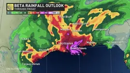
Beta remains "trapped" between a ridge over Florida and another over the southern Plains. With its centre just offshore, it continues to tap into Gulf moisture. As laden with moisture as it is, that slow pace will give it plenty of time to absolutely drench the coasts of Texas and Louisiana, with 150-300 mm of rain possible, and isolated amounts of 375 mm not out of the question. Rainfall totals of 75-125 mm are expected northward into the Ark-La-Tex region and east into the lower Mississippi Valley.
The storm or its remnants will eventually move inland up the Mississippi, bringing more rain and flood potential for areas away from the coast. "Flash and urban flooding is likely, as well as minor to isolated moderate river flooding," the NHC says. Another hazard will be storm surge, with many coastal Texas and Louisiana areas expected to see a storm surge up to 1.5 metres. As well, a tornado or two could occur Monday near the middle-to-upper Texas coast or the southwestern Louisiana coast.