the priest map or witch map

I like your Wizard monument!

I have a photo somewhere of one looking at the numeral "2".

For someone that couldn't see anything in the photo's I posted early on, and then I had to outline the photo signs in Gimp and re-post for your skeptical viewing, you sure came about with your
"Sign Reading Ability".

Good work!

Would you like to see some of those photo's now?

View attachment 1382212

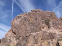
Superstition Mountain from Travis's perspective. Notice the Wizard or Priest looking at the bell= that way to the Mission. Triangles, hearts, "X's", "V's", and a bird stepping on top of a peak just out of range on the right of the photo for the next set of signs to the Treasure Site.

View attachment 1382213

Goosy the Goose=water

View attachment 1382217

Fish=Water with a bird, a pointer, a face and a Priest.

View attachment 1382218

Horse of Santa Fe
 

Last edited:
Seems to work OK.....

At least you can see a hole just about where one would expect to.

The other "1" still works, with the shape of the crevice/wash just to the left being like that of the dagger, and the tip/point being the pointed hat on the smaller priest at the top of the crevice. In that case, the path could be interpreted as direct to the heart cache.....an easy up and over the mountain and considerably less dangerous, especially with pack animals. No markers necessary, since it's the only viable path, beat down as well and easy to follow.

The hole is not visible from this vantage point, and the only hole I've been able to find that's close seems inconsequential (in a rock outcrop and facing the other way).
However, the other matches are pretty close, and the trail crosses the crevice where the "arrow" crosses the dagger. All this leaves me little doubt that the person who made the original map (stone/paper/whatever) used the same visual aspects as we see there today.
But still.......the missing hole in this view ?
Perhaps it's part of the whole that's needed for fulfillment of one's "Santafe" and a "Cursum Perficio" ???
Seems everything fits a pattern....1 of 2...2 of 3....3 of 4.....4 of 5......5 of ?.......? of 7........etc .
In other words...."You ain't there yet !"


Sorry, I meant the "1" in this picture that you posted a while back:

MEX and 1.webp

There is also another and bigger "1" to the left of this that also points to the hillside heart. Looking more and more to me now that the "1" is more of a directional signifier than a number.
 

Looks like you're almost there Bill.
Follow that goose all the way to her basket of golden eggs, I'd say.

I been looking for something else though, and mainly using another very unique map that Travis obviously hadn't found.....or made himself. Probably didn't even know about it, and I don't think he would have understood it even if he had seen it. Never seen a map like it before, other than kinda similar modern maps that show cavern systems for cavers. Two levels, maybe three, with four ways to access the interior passages....all marked differently. One way in, which looks to be a "man" door, also appears to have a dead fall trap which is triggered by pressure on a false floor slab just inside . Fortunately.....I THINK !!.....the illustration also shows a "safety pin", and where to insert it. Looks like the same set up that we see on the priest's sleeve, which if proven true in practice, will explain what that's all about. Could even be what's hanging over that heart in my earlier photo from this thread....or one with a strangely offset long end that I came across somewhere else out there years ago. But I sure ain't going in until I know what's what.
 

Sorry, I meant the "1" in this picture that you posted a while back:

View attachment 1382233

There is also another and bigger "1" to the left of this that also points to the hillside heart. Looking more and more to me now that the "1" is more of a directional signifier than a number.

A little bit around to the right, in the direction of the M Heart, and you will see the "1" that I posted yesterday.
I don't think you can see both at the same time though.
 

Seems to work OK.....

View attachment 1382026

At least you can see a hole just about where one would expect to.

The other "1" still works, with the shape of the crevice/wash just to the left being like that of the dagger, and the tip/point being the pointed hat on the smaller priest at the top of the crevice. In that case, the path could be interpreted as direct to the heart cache.....an easy up and over the mountain and considerably less dangerous, especially with pack animals. No markers necessary, since it's the only viable path, beat down as well and easy to follow.

View attachment 1382033

The hole is not visible from this vantage point, and the only hole I've been able to find that's close seems inconsequential (in a rock outcrop and facing the other way).
However, the other matches are pretty close, and the trail crosses the crevice where the "arrow" crosses the dagger. All this leaves me little doubt that the person who made the original map (stone/paper/whatever) used the same visual aspects as we see there today.
But still.......the missing hole in this view ?
Perhaps it's part of the whole that's needed for fulfillment of one's "Santafe" and a "Cursum Perficio" ???
Seems everything fits a pattern....1 of 2...2 of 3....3 of 4.....4 of 5......5 of ?.......? of 7........etc .
In other words...."You ain't there yet !"

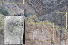
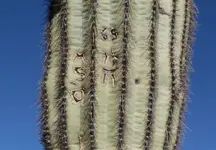
I've got the same exact dagger on a stone marker & a saguaro!
 

I've got the same exact dagger on a stone marker & a saguaro!

That dagger must have had particular meaning to someone, or perhaps several folks, back when this took place.
Kinda like a CCW or the switchblades and flick knives of more modern times.
Cuts both ways...thinner blade...sharper point etc, could be considered a clue or clues. Definitely not a utility knife, nor what most prospectors or other explorers would carry and use.
Other markers use a single edged knife as does this one, for example....

1231 glyph panel.webp

Still, the dagger on the Trail Map might only be what the map maker thought the crevice and smaller priest figure looked like.
Good enough to use on the map as a reference point, in thinking that followers might see the same.

Another marked saguaro I've seen....

1965 ?
If so, then it was done 51 yrs ago.

marked saguaro.webp
 

Last edited:
Looks like you're almost there Bill.
Follow that goose all the way to her basket of golden eggs, I'd say.

I been looking for something else though, and mainly using another very unique map that Travis obviously hadn't found.....or made himself. Probably didn't even know about it, and I don't think he would have understood it even if he had seen it. Never seen a map like it before, other than kinda similar modern maps that show cavern systems for cavers. Two levels, maybe three, with four ways to access the interior passages....all marked differently. One way in, which looks to be a "man" door, also appears to have a dead fall trap which is triggered by pressure on a false floor slab just inside . Fortunately.....I THINK !!.....the illustration also shows a "safety pin", and where to insert it. Looks like the same set up that we see on the priest's sleeve, which if proven true in practice, will explain what that's all about. Could even be what's hanging over that heart in my earlier photo from this thread....or one with a strangely offset long end that I came across somewhere else out there years ago. But I sure ain't going in until I know what's what.

You'd think you only see this stuff in an Indiana Jones movie, eh?
 

Looks like you're almost there Bill.
Follow that goose all the way to her basket of golden eggs, I'd say.

I been looking for something else though, and mainly using another very unique map that Travis obviously hadn't found.....or made himself. Probably didn't even know about it, and I don't think he would have understood it even if he had seen it. Never seen a map like it before, other than kinda similar modern maps that show cavern systems for cavers. Two levels, maybe three, with four ways to access the interior passages....all marked differently. One way in, which looks to be a "man" door, also appears to have a dead fall trap which is triggered by pressure on a false floor slab just inside . Fortunately.....I THINK !!.....the illustration also shows a "safety pin", and where to insert it. Looks like the same set up that we see on the priest's sleeve, which if proven true in practice, will explain what that's all about. Could even be what's hanging over that heart in my earlier photo from this thread....or one with a strangely offset long end that I came across somewhere else out there years ago. But I sure ain't going in until I know what's what.

All the shadow symbols except the one from Travis's campsite are of the Catalina's and lead to Pima Spring. That includes the water symbol the Goose or Duck. I don't think there's any golden eggs there in Pima Spring it's more of a warning from the Egyptian God GEB the Great Cackler or purveyor of Thunder and Earthquakes. That'll make your golden eggs rock and roll! I have seen the Goose in smaller size only as a rock carving nearer to the Gold Mine with Treasure. That was one of the main spells cast for protection of the secret entrance into the realm of Satan's Lair. But only the penitent man shall pass the three tests of Satan. I know the location of one of these huge death traps. It could take out the Dalmer Party! (That is, before they would've ate their self.)

Show up some parts of your Map please. That is what I would like to see and I'm sure others on here to.
 

You'd think you only see this stuff in an Indiana Jones movie, eh?

My thought as well. I had, until recently, considered the various maps that we had been working with as more than anything I had ever seen a treasure movie plot wrapped around.
But this is way beyond any and all of that, so far as I can see. Authentic and dateable IMO. I've spent many hours, both at home and on the site, comparing what I see here AND there....above ground, and can say that the ambiguity built into the other maps has not been employed with this one. If the same holds true for the layout of the inside, it's gonna get real interesting.....but I don't think it'll be a cakewalk and likely risky to some extent. There's no list of what might be in there, however a historical account of a situation where a gold-laden draft horse....likely wounded.... and his (padre) handler were both lost, might be a link to at least a portion of the contents.
 

Last edited:
All the shadow symbols except the one from Travis's campsite are of the Catalina's and lead to Pima Spring. That includes the water symbol the Goose or Duck. I don't think there's any golden eggs there in Pima Spring it's more of a warning from the Egyptian God GEB the Great Cackler or purveyor of Thunder and Earthquakes. That'll make your golden eggs rock and roll! I have seen the Goose in smaller size only as a rock carving nearer to the Gold Mine with Treasure. That was one of the main spells cast for protection of the secret entrance into the realm of Satan's Lair. But only the penitent man shall pass the three tests of Satan. I know the location of one of these huge death traps. It could take out the Dalmer Party! (That is, before they would've ate their self.)

Show up some parts of your Map please. That is what I would like to see and I'm sure others on here to.


Can't do that yet, Bill.
I'm not the only one who has seen it, or been to that part of the mountains.
The folks who made it and did all this might still know something about it as well....or even have a copy or something similar in their own collection.
Don't want anyone leapfroggin me, now that I have had my first look at the end. And so far, nothing important looks as though it has been disturbed, so I'd rather it stayed that way.
If that object across the small heart is the safety pin, I want that to still be there as well, when I get a chance to go back for part 2.
 

Looks like your almost there.

I've been studying at my final location working it hard for many years just as you. Not where your at in the Supers, that would lead to a conflict of interest. But, studying rock and sun /shadow monuments around old Spanish Gold Mines has been my main teacher for many years now. I can safely say this:

"If there are no old prospects near your site you're not in the right area".

The Spanish would lead you to these prospects on purpose with symbols like hearts, triangles, birds, pointers, "X's" etc. They did this so you would find those prospects real easy. Even Priest's or Witches, Horse's, what have you. They wanted you to find the lost leaders. They used the lost leaders themselves to find the measuring monuments for the real Mines / Treasures. It's a plain trail easy to read that leads to two of these prospects within a couple of hundred yards of each other. I firmly believe the Treasures are all with in the mine tunnels of these hidden chambers near the lost leaders. Each of these locations through out Arizona has proven this to me over and over again. Although modern man has destroyed a lot of the monuments near some, they still project the same types of monuments used in different fashions. It was and is a flexible system for utilizing similar signs and symbols over a large area.

Both sets of stone maps have some of these mine locating symbols, but, only for finding the lost leaders. Once you do find these the real map is contained near that site in a map room or camping area designated for the Jesuit Polymath that I believe was also a Knights Templar 33rd degree mason. Just like the site I found with final Skull that has a drill hole in it for measuring and the map room with the numerals for finding the real entrance from that drill hole measuring point at the other location.

Just think about what I just said. Up until now Archeologists have only recently discovered a small sliver of light utilizing the sun for pointing out the Solstice and the beginning of planting or harvest seasons. Never before has any written roman numeric ever been located proving a system beyond a simple sliver of sun light been found until now. It opens up larger possibilities of a much greater science beyond what many have given any ancient group credit for.

Like the possibility of mountains sized shadow billboards everyone has totally dismissed. The jump from rock, to sun, to shadow. They use rock monuments to show where you'll see the projected timed shadow or sun sign appear. That in turn gives you the distance, direction from the drill hole to the concealed entrance, not the death trapped entrance. I've given to much out for now you'd have to sign a your life over to God for further knowledge.

You can see the profile skull in the photo with the heart shaped window of reflected sun and the shadow numeral "75". Next to the numeral in the sun window is what looks to be a measuring stick or chicken ladder, or a representation of a measuring rope all in brighter sunlight reflected. This is what Travis was looking for, this is what the key is, this is what the trail map shows with the sun symbol and numerals. This, is follow the heart, follow the map!

I know how to get to this point on any site because the precursor's you follow to reach this point, I'm not disclosing. You can see it's a no brainer. Even though it took me two years to discover what the rock monument that lead me here was attempting to convey, in the end it gave me the proper time of day and year for this to appear. Before that, I was just about to give it up. Only the map room contains this final measurement. The map room is no where near the measuring monument for using this measurement numeral. But, only two Skulls adorn the mountain, the beginning, and the end.

This system can be complicated until you realize what the keys are. Alpha, Omega!

Janus: "I am the beginning and I am the end".


View attachment 1382883
 

Bill

You are right . the stone tablets/maps and all the travel (1) from the beginig of the trail until the treasure from the LH , were made in a masonic concept/mindset .
The travel starts following 18 signs over a dangerous path . After these 18 signs , you reach a cave/mine ( 2 ) which on its wall has instructions to find the map room . Finding the map room ( 3 ) , where there are all the stone maps , have to decipher the Priest stone map to find where the LH ( 4 ) and the SC lie .

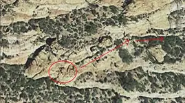
A GE image of the MEUS territory in the LH , looking from the Fauces place .

meus.webp
 

Last edited:
Bill

You are right . the stone tablets/maps and all the travel (1) from the beginig of the trail until the treasure from the LH , were made in a masonic concept/mindset .
The travel starts following 18 signs over a dangerous path . After these 18 signs , you reach a cave/mine ( 2 ) which on its wall has instructions to find the map room . Finding the map room ( 3 ) , where there are all the stone maps , have to decipher the Priest stone map to find where the LH ( 4 ) and the SC lie .

A GE image of the MEUS territory in the LH , looking from the Fauces place .

View attachment 1382953

Thanks, I believe the maps were read: "I AM" 18 PLACES" Janus: "I AM" the beginning and "I AM" the end! It translates two ways. I go, or, I am.
The map room lays out pointers that correspond to the sun rise & set, at that time of year. The remaining pointers give the solar day times and direction for the signs to appear! You need only look at that time of year and capture the numerals with the pointer. Although the true direction or distance may not be shown that too appears at 3PM. (2=3) With the sign in the photo this sites keys are set at 2PM and 3PM respectively in November. Just as the map room said it would when the sun lines up with the large "A" pointers I've posted on here before. Lying on top the "A's" is a key that involves a Moses type Staff or in my case a steel rod being inserted into two hands facing different directions cut for that purpose. Both hands have a hole drilled in the palm of them as if grasping the rod you insert. That will get you the sun rise of the year and day time for the viewing. Each sign will have this type of display only if you're near one of these, no where else. They didn't use these just anywhere!

It's a solar timed base system. You need real patience for this sort of work!

It's a Virtual Treasure map hidden in solar time!
 

Marius,

PS: The daytime pointer shows the relative position of the sun during the arch in the solar day. Sunrise is easy to spot at first light, but, the position of the daytime arch of sun was a stumper! A good compass and time piece was used. These only appear for about fifteen minutes at that time of the solar day.
 

Going by what you guys are saying and the photos and GE views you've posted, it looks like I'm working with a completely different set of circumstances, and a whole lot less in the way of these treasure signs and symbols that you and others use to find everything else under the sun. Seems to me that a really smart perp wouldn't use what meant this or that in particular, at least on the landscape where anyone passing by might see and recognize it for what it meant to the perp himself. Likewise, the idea of accumulations of treasure hidden in old mines also seems a bad idea to me, seeing as how there are always signs of mining left behind no matter how well the shafts might be hidden. The bigger the mine, the more people were involved, so all those who mined or witnessed the work also become a problem. Although there were about a half dozen mines within the greater area I'm interested in, all seem to be small 1900's projects from what I have been able to research on them. Nothing around that appears to be related to the LDM clues, unless JW just happened to stumble on a cache of ore placed in temporary storage nearby that had to be abandoned for some reason.
 

Last edited:
Going by what you guys are saying and the photos and GE views you've posted, it looks like I'm working with a completely different set of circumstances, and a whole lot less in the way of these treasure signs and symbols that you and others use to find everything else under the sun. Seems to me that a really smart perp wouldn't use what meant this or that in particular, at least on the landscape where anyone passing by might see and recognize it for what it meant to the perp himself. Likewise, the idea of accumulations of treasure hidden in old mines also seems a bad idea to me, seeing as how there are always signs of mining left behind no matter how well the shafts might be hidden. The bigger the mine, the more people were involved, so all those who mined or witnessed the work also become a problem. Although there were about a half dozen mines within the greater area I'm interested in, all seem to be small 1900's projects from what I have been able to research on them. Nothing around that appears to be related to the LDM clues, unless JW just happened to stumble on a cache of ore placed in temporary storage nearby that had to be abandoned for some reason.

Anglos have later worked these old prospects this is probably one reason why. The prospects near those signs I posted have both been worked and claimed later by whites. With one exception of three German men near there that I found the claim form in a monument. Going back to Kenworthy's finding of the mine shaft "Plug" made from a carved tombstone shaped rock with a heart and lightening bolt it seems relatively easy to use, the lost leaders can be used for your tailing piles and to clean up the actual entrance for concealment. Waltz himself cleaned up his site and no one has ben able to find it since whether a cache or not. Since the main mine entrances were death trapped and the hidden concealed entrance coded for Walkers only, I believe it makes perfect sense to use these hidden chambers for Treasures. Storage is another issue. It could conceivably be used as storage just as easy as Treasure. In some of these God Forsaken desert locations we've all been to it's hard to fathom using more than one underground chamber for all of the above when you already have the one in front of you. Tailings or not.
 

Going by what you guys are saying and the photos and GE views you've posted, it looks like I'm working with a completely different set of circumstances, and a whole lot less in the way of these treasure signs and symbols that you and others use to find everything else under the sun. Seems to me that a really smart perp wouldn't use what meant this or that in particular, at least on the landscape where anyone passing by might see and recognize it for what it meant to the perp himself. Likewise, the idea of accumulations of treasure hidden in old mines also seems a bad idea to me, seeing as how there are always signs of mining left behind no matter how well the shafts might be hidden. The bigger the mine, the more people were involved, so all those who mined or witnessed the work also become a problem. Although there were about a half dozen mines within the greater area I'm interested in, all seem to be small 1900's projects from what I have been able to research on them. Nothing around that appears to be related to the LDM clues, unless JW just happened to stumble on a cache of ore placed in temporary storage nearby that had to be abandoned for some reason.

Sometimes it might be a good idea to hide something in plain sight, so to speak. How about a short "exploration drift", or a genuine mine site that played out early, leaving a barren, empty drift or relatively shallow shaft and a typical modest dump on the hillside? The kind of place that a thousand folks have come across, inspected and said, "Huh. Old tunnel. Nothing more to see here. Not even decent ore samples on that dump. Let's move on." Might be a clever false floor in that drift. Might be a well-hidden niche in the bottom of that shaft. Might be a s ---load of bullion buried in that barren dump.
 

Marius,

PS: The daytime pointer shows the relative position of the sun during the arch in the solar day. Sunrise is easy to spot at first light, but, the position of the daytime arch of sun was a stumper! A good compass and time piece was used. These only appear for about fifteen minutes at that time of the solar day.

Bill

The signs on the trail are both solar and carvings . For example , at the start of the trail are shadows of an arrow and a " P " letter .

shadow signs.webp
 

Sometimes it might be a good idea to hide something in plain sight, so to speak. How about a short "exploration drift", or a genuine mine site that played out early, leaving a barren, empty drift or relatively shallow shaft and a typical modest dump on the hillside? The kind of place that a thousand folks have come across, inspected and said, "Huh. Old tunnel. Nothing more to see here. Not even decent ore samples on that dump. Let's move on." Might be a clever false floor in that drift. Might be a well-hidden niche in the bottom of that shaft. Might be a s ---load of bullion buried in that barren dump.

Exactly! This is exactly how the first mine / treasure I found came to be! I had a claim on it for five years just enough time verify a huge metal object at 60 feet down an old back filled shaft that looked like a played out prospect! We dug that thing down knowing it may have a false floor underneath us.

Ron Quinn allegedly found a shaft back seventy five although that claim may be false I just recently learned. Ron Feldman and his boys also dug out an old shaft looking for gold. It only makes sense. If the secret entrance into the real tunnel can be found (Rabbit Hole) than we might get our answers.

Of course you may just find an old dead body down there of an unsolved murder so it's a gamble!
 

Bill

The signs on the trail are both solar and carvings . For example , at the start of the trail are shadows of an arrow and a " P " letter .

View attachment 1383415


Your right Marius! Rock is always a great way of making your trail permanent. Visible letters or signs that appear only at certain times of the day is just a neat way of concealment or out right in your face evidence of the system used.

But, the Janus symbol has a meaning. It's a cross roads between the beginning and the end. What symbol can best personify Janus?

The Skull!

Death= Skull, a transition from death of one life into birth of the afterlife! What greater symbol to use for hiding a death trapped entrance or a secret dark symbol with in the light? At least for the site I've been working the Skull is the main "Key" to all that matters in the mountain. I cannot vouch for any other area's as I have seen other methods, but, all remain similar to that one. Stone is everlasting, the sun is everlasting, using stone and the sun as a means to hide gold is almost everlasting. (1000's of years)
 

Top Member Reactions

Users who are viewing this thread

Back
Top