the priest map or witch map

For me, this new information puts the large hillside rubble heart on the backside (to which that erect red heart presumably refers to) in a whole new light, especially with the new positioning of SANTAFE.

If it does refer to the area that I think it does, this then becomes a much bigger endeavor than I previously imagined.

AND spread out over a larger area than I had assumed, but my own "back door" theory finally seems to have borne some fruit.
The direct route to the triangle, as shown on the UTS and the red (crimson?) heart does suggest an "up and over and down" path from the "1" to a place presumed to be of some importance. We know that the directional lay of the land is accurately represented by the line to which that triangle points, and that the mound of rubble is located at that position (relative elevation) as well. That the symbol used to "symbolize" Calvary Hill, or "other" small hill, applies very well in this case, as does the positioning and style of the six oval markings on the back of that heart, since only the one side and the point of the pile .....the unbroken, larger piece of the heart.... is composed of or filled with broken rock. That the upright red heart in my photo also has a corresponding "break" is not likely a coincidence IMO. Nor the other lines !
Even though I'm reluctant to place much of my own faith in the two trail stones, given the presentations by RG and the Tumlinsons to date, there are a number of problems with the evidence shared so far, including a couple of wild cards that they apparently are unaware of. But like a good game of Texas Hold Em...... it's the pot that counts and the showdown that delivers it.
 

Last edited:
AND spread out over a larger area than I had assumed, but my own "back door" theory finally seems to have borne some fruit.
The direct route to the triangle, as shown on the UTS and the red (crimson?) heart does suggest an "up and over and down" path from the "1" to a place presumed to be of some importance. We know that the directional lay of the land is accurately represented by the line to which that triangle points, and that the mound of rubble is located at that position (relative elevation) as well. That the symbol used to "symbolize" Calvary Hill, or "other" small hill, applies very well in this case, as does the positioning and style of the six oval markings on the back of that heart, since only the one side and the point of the pile .....the unbroken, larger piece of the heart.... is composed of or filled with broken rock. That the upright red heart in my photo also has a corresponding "break" is not likely a coincidence IMO. Nor the other lines !
Even though I'm reluctant to place much of my own faith in the two trail stones, given the presentations by RG and the Tumlinsons to date, there are a number of problems with the evidence shared so far, including a couple of wild cards that they apparently are unaware of. But like a good game of Texas Hold Em...... it's the pot that counts and the showdown that delivers it.

And in this regard, the SANTAFE becomes a sort of "pssst, there's more over here."
 

To ignore is not in my character and I have learned to hear others opinions .
I believe how could exist a connection between the rubble stone heart from your photo with the scratched heart under the word " Coazon " from the PS , but only as a sign to follow to the real LH .
To me , more important is the " -M " symbol at the right of the scratched heart from the PS . Is what says the third and the fourth verse on the PS . The transition from the " Mapa " to the " Coazon " , not in the order which are written on the stone , but how these two are situated in the field . Also the line shows the only accessible rubbleplace to approach the LH .
I believe the word " Coazon " is a misspelling like many other words on these stone tablets/maps .

If you believe how what I'm writing is a guess or a fictional story , feel free to ignore too .

The line and "M" IS instructive, in that it does show the direction that one has to proceed in order to get to the heart-shaped hill of rubble.
It also could be interpreted to indicate which side of the heart contains the cache or caches, should the six ovals indicate that there are six caches arranged as shown on the back of the red heart stone. The heart itself is 112 ft x 132 ft, and about 20 ft high on the ruble side, which could make each of the six caches about the size of a single car garage if drawn to scale.
Although I consider this to be a secondary target, and possibly where durable items such as gold or silver bars might be buried, I no longer believe the LH or CP apply to this area.
The "M" could, and likely does have more than one interpretation, but in this case a narrow pass lies between the upright heart in my photo and the heart shaped mound of rubble.
The Spanish word for mound is "Monteculo", which may be a clue and alternate interpretation as well.
 

And in this regard, the SANTAFE becomes a sort of "pssst, there's more over here."

Perhaps.
Both characters, H & P, are orientated in that direction.....towards the end of the stone where the "SANTAFE" appears between the two lines, which in the field are both well worn trails.
That both trails also have recognizable symbols and natural features visible from or along them, as most trails through mountainous terrain do, is a plus IMO.
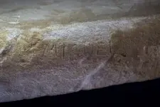
The positioning and orientation of the "MIGUEL", as well as that the "M" matches the style of the M found to the right of the scratched heart also points to that area up top.

One of Mike's photos..... miguel Mike's.webp
 

Last edited:
The line and "M" IS instructive, in that it does show the direction that one has to proceed in order to get to the heart-shaped hill of rubble.
It also could be interpreted to indicate which side of the heart contains the cache or caches, should the six ovals indicate that there are six caches arranged as shown on the back of the red heart stone. The heart itself is 112 ft x 132 ft, and about 20 ft high on the ruble side, which could make each of the six caches about the size of a single car garage if drawn to scale.
Although I consider this to be a secondary target, and possibly where durable items such as gold or silver bars might be buried, I no longer believe the LH or CP apply to this area.
The "M" could, and likely does have more than one interpretation, but in this case a narrow pass lies between the upright heart in my photo and the heart shaped mound of rubble.
The Spanish word for mound is "Monteculo", which may be a clue and alternate interpretation as well.

For this is so fascinating to search for the hearts . The mapmaker gave to those maps a multiple ways to be interpreted . Made also and some obstacles in the way to that treasure . Obstacles that could lure the researchers to a wrong path and direction .
Nobody can find anything without finding the end of the trail . Even decrypting what the Priest "says ' and shows , all are in vain without knowing where is the end of the trail .
The only difficulty , is , how anybody could recognize the end of the trail now when the stone maps are not there ?
Of course at that cave exist some signs which are known to a very closed circle of people , but the most important is to recognize the landmarks around if fit with the landmarks carved on the stone map and to find some of the " lugares " that are depicted on the map .
 

Last edited:
For this is so fascinating to search for the hearts . The mapmaker gave to those maps a multiple ways to be interpreted . Made also and some obstacles in the way to that treasure . Obstacles that could lure the researchers to a wrong path and direction .
Nobody can find anything without finding the end of the trail . Even decrypting what the Priest "says ' and shows , all are in vain without knowing where is the end of the trail .
The only difficulty , is , how anybody could recognize the end of the trail now when the stone maps are not there ?
Of course at that cave exist some signs which are known to a very close circle of people , but the most important is to recognize the landmarks around if fit with the landmarks carved on the stone map and to find some of the " lugares " that are depicted on the map .


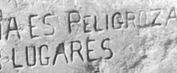
LUGARES triangle.webp

That the upper part of the "A" in the word "LUGARES" has been removed, may be a clue to what the drilled dots along the "trail" are in the field.
The "triangle" symbol plays a big part in all of this, especially at the end of the trail.
 

View attachment 1380848

That the upper part of the "A" in the word "LUGARES" has been removed, may be a clue to what the drilled dots along the "trail" are in the field.
The "triangle" symbol plays a big part in all of this, especially at the end of the trail.

Could be , but I believe the triangle has nothing to do with the end of the trail .
The arched line from the UTS which begins from the #1 ( Arabic ) and ends at the triangle , is what " says " the Priest in the first verse " Esta bereda es peligroza " , which means the whole travel , from the start of the trail in the LTS ( second verse and third - or the numbers 2 and 3 from the PS and the LTS ) till the triangle in the LH ( #4 in the PS and the fourth verse ) .
As I have wrote , the stone maps are close related each other .

Marius,

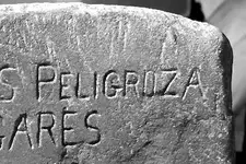
Take a closer look at the picture somehiker posted. Do you see a small symbol in the G of peligroza?

That it is to the left of the "R," just as in the field, is yet another clue that the misspelling of coazon is intentional.

And yes, the triangle is everything. You see it on everything associated with the Stone Maps, both sides of the H/P stone, and on both trail maps, the Stone Crosses, and the CP paper.
 

The triangle also appears in one place on the map required at the main entrance to the "underworld". This entrance and a second are well hidden from view, except from within that triangle.
It also shows a third entrance down below, but that one will need to be opened from the inside I suspect. All three surround the triangle in the same fashion as the three dots on the illustration of the triangle I posted earlier. Each of the triangles on the UTM, SC and CP also illustrate this triangle IMO, although none show a passage to the upper right. Could have something to do with which way you are facing, since the outbound line on the SC is a single line, whereas the outbound line on the CP is a double line.
 

?????????????

The "A" Itself is one of the most important symbols at the end of the trail!

As with every "Spanish coded Map". The Triangle is at the end, so is the Horse, Goose, Skull, Lion, Croc, Wolf, Turtle, Snail and of course walkers monuments!

The "Tongue" and "Mouth" symbolize keys and doors as does the Multi-Headed Janus symbol. The Wizard had to put himself in there as he set the site up for the good of the crown.

The Elephant is an Alpha Omega symbol and can be found near both the beginning or at the end. Most of these symbols are missing from the stone maps. Because Travis only forged a part of the complete mapping system. No one has it all that I've ever heard of. Just pieces.

The A maps can be found as cracks in the bedrock or as seams in the rock floor it depends on the surrounding monuments as to whether it's a relevant map.

You're all getting there.
 

Last edited:
Marius,

Take a closer look at the picture somehiker posted. Do you see a small symbol in the G of peligroza?

That it is to the left of the "R," just as in the field, is yet another clue that the misspelling of coazon is intentional.

And yes, the triangle is everything. You see it on everything associated with the Stone Maps, both sides of the H/P stone, and on both trail maps, the Stone Crosses, and the CP paper.

deducer

What you see as a symbol in the " G ' , i believe is nothing more than an imperfection of the stone surface .

The words could be misspelled intentionally , but don't forget how till the early of 19th century , the Spanish language was not stabilized to what today is . They used as Spanish language a mix of many dialects from the many regions of the Spain .(this also was a critical clue on the Reavis documents , which the General Surveyor didn't take or maybe didn't want to take in consideration )
 

Last edited:
deducer

What you see as a symbol in the " G ' , i believe is nothing more than an imperfection of the stone surface .

The words could be misspelled intentionally , but don't forget how till the early of 19th century , the Spanish language was not stabilized to what today is . They used as Spanish language a mix of many dialects from the many regions of the Spain .(this also was a critical clue on the Reavis documents , which the General Surveyor didn't take or maybe did't want to take in consideration )

Look closer:

Gheart.webp

The devil is in the detail, as they say.
 

The line and "M" IS instructive, in that it does show the direction that one has to proceed in order to get to the heart-shaped hill of rubble.
It also could be interpreted to indicate which side of the heart contains the cache or caches, should the six ovals indicate that there are six caches arranged as shown on the back of the red heart stone. The heart itself is 112 ft x 132 ft, and about 20 ft high on the ruble side, which could make each of the six caches about the size of a single car garage if drawn to scale.
Although I consider this to be a secondary target, and possibly where durable items such as gold or silver bars might be buried, I no longer believe the LH or CP apply to this area.
The "M" could, and likely does have more than one interpretation, but in this case a narrow pass lies between the upright heart in my photo and the heart shaped mound of rubble.
The Spanish word for mound is "Monteculo", which may be a clue and alternate interpretation as well.

The only question I would have in regard to this is what role the "MEX" (or rather SONORA MEX) plays in the context of what you discuss here, it is up and to the right of the 'M' heart, as you know.
 

The only question I would have in regard to this is what role the "MEX" (or rather SONORA MEX) plays in the context of what you discuss here, it is up and to the right of the 'M' heart, as you know.

I haven't shown you the "M" heart, so I'm assuming that you have seen it.
If so, then you know that all of Colonial Sonora, first named so in 1648, and growing to include all of Az. south of the Gila River during Kino's time, lies in the direction to the rear of that heart. The "MEX" as shown on the stone, and in the field as you know, also seems to indicate a direction to the "M" heart, which may also indicate a changeover point from one map to another. Finding the "SONORA" might give further insight into this part of the puzzle. I may have done so, but can't confirm this as yet.
 

Ya and the Planets are in there to.

Right next to the "M" for moon and "G" for Travis the Great.

Great stone map Propaganda. The Heart is merely one of the symbols of Royalty. There are many, many hearts along all trails. I have gob's of heart photo's. It's no secret the Spanish used hearts all over the place. To say a heart of one nature or another is of more value than another is not true. It only has value when it's accompanied with other symbols at that spot. You guys know this. The Stone Maps depict nothing of value being as they're made as lost leaders by Travis. All of the stone map series whether made by Travis or copycat stone crosses seem to be fake. Following them is like following a fairy tale at this juncture.

FYI Sonora is just outside of Kearny. Manje's Hacienda. Place of Manje. That was the site of an old Mission of Kino's design. It was put in the middle of many gold mines.

Heart of Gold get it?
"7"

Don't say the Trail Stones are the fake ones, it may be the other way around, I see the day time solar marks in there so they have some validity. Some sun signs in shadow or shadow signs in the sun are viewed at 2PM and some at 3 pm (2=3) with others in the morning at 7 and 8. (18=7). Only problem is they made the numeral 7 with a cross bar.

Lots of symbols on both maps can be found in the field so there had to be some knowledge with in the forger or makers bag. Where did that knowledge come from? I guess we'll have to wait for Ryan's show about Travis for that. In that respect I can still see some loyalty still attached by his followers. I've said it before the Maps are fraught with real symbols that represent abstracts of monuments and real life treasure signs. Do they lead somewhere?

We all don't know yet.
 

I think all of us are still enjoying this topic Bill, regardless of which side of the fence their interest in the Travis & Tumlinson Stone Map Saga sits.
 

I enjoy it. I looked for those symbols and studied those maps for years. I enjoyed it then, and I enjoy it now. It's surely a brain teaser. It only just remains who's brain it came from. Carry on, I'm not knocking it.
I believe more in the Gematria in the letters on the HP map. It gives a longitude and latitude for an old mission site down in Mexico south of Douglas. Possibly the origins of the original parchment or pigskin Map? Sonora Mex maybe? Puzzles are a good thing. Right now it seems the puzzles only lead to one man. But, That could change in a moment. I learned a lot from the stones. It's a good starter for anyone just getting into the Treasure Hunting field. Keep up the good debate.
 

I haven't shown you the "M" heart, so I'm assuming that you have seen it.
If so, then you know that all of Colonial Sonora, first named so in 1648, and growing to include all of Az. south of the Gila River during Kino's time, lies in the direction to the rear of that heart. The "MEX" as shown on the stone, and in the field as you know, also seems to indicate a direction to the "M" heart, which may also indicate a changeover point from one map to another. Finding the "SONORA" might give further insight into this part of the puzzle. I may have done so, but can't confirm this as yet.

The "1" up and to the right of the "MEX" makes a lot more sense in this context.
 

The "1" up and to the right of the "MEX" makes a lot more sense in this context.

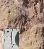
Seems to work OK.....

DSCF1267 1B.webp

At least you can see a hole just about where one would expect to.

The other "1" still works, with the shape of the crevice/wash just to the left being like that of the dagger, and the tip/point being the pointed hat on the smaller priest at the top of the crevice. In that case, the path could be interpreted as direct to the heart cache.....an easy up and over the mountain and considerably less dangerous, especially with pack animals. No markers necessary, since it's the only viable path, beat down as well and easy to follow.

View attachment 100_0748 dagger detail.bmp

The hole is not visible from this vantage point, and the only hole I've been able to find that's close seems inconsequential (in a rock outcrop and facing the other way).
However, the other matches are pretty close, and the trail crosses the crevice where the "arrow" crosses the dagger. All this leaves me little doubt that the person who made the original map (stone/paper/whatever) used the same visual aspects as we see there today.
But still.......the missing hole in this view ?
Perhaps it's part of the whole that's needed for fulfillment of one's "Santafe" and a "Cursum Perficio" ???
Seems everything fits a pattern....1 of 2...2 of 3....3 of 4.....4 of 5......5 of ?.......? of 7........etc .
In other words...."You ain't there yet !"
 

Last edited:

Top Member Reactions

Users who are viewing this thread

Back
Top