The Peralta Stone Maps, Real Maps to Lost Gold Mines or Cruel Hoax?

Do you think the Peralta stone maps are genuine, or fake?


  • Total voters
    121
If "topic moderator" makes you happy I stand corrected. I reiterate; I nor anyone I know had anything to do with the removal of the thread. Other than grammatical clarity, what is your point?

The Stone Maps are near a religion to many. Too much so. They have caused much misery to just about everyone that gets too close to them. You want a story? That's a story worth telling. Hurt feeling, broken friendships, lost fortunes, lost lives.....and the beat goes on.

Maybe someone should open up a church called "The Church of The Peralta Stone Saints" in Arizona...LOL...I wonder if it would be non denominational and it could possible even qualify as a non profit entity for tax purposes...rofl...

Some people take the stone maps way too seriously...It is just another form of earlier treasure maps...Who knows...Hell...They might even be descended from the tale of Atlantis or King Solomon's mines...Who can say for certain???

Of one thing I am certain...Someone went through a lot of trouble to create such treasure tales and maps over the centuries to get people out there searching for whatever it is at the end of the rainbow...

It must be one heck of an important treasure to get so many people out there searching for it...I wonder what it might be???Maybe one day we may learn the answer...
 

The Egyptians had paper and ink from the year 2560 BCE.

Yet they carved EVERYTHING in stone. Even Egyptians laundry receipts have been found carved in stone.

Why ?

Because paper burns, and when it gets wet the ink runs and the paper disintegrates.
If you need to preserve something very important for a very long time like a map to a treasure you don't trust paper, you carve it in stone so it will be preserved through fire and flood.

This is what I believe the Spanish and Mexicans did in northern New Spain and Pimeria Alta. They were at times a long way from civilization and not trusting things to a mere paper map they carved directions in stone and often coded the directions so if the stone fell into the hands of others it would be worthless to them.

In a place like southern Arizona the same would have been true for 1589, or 1677, or 1767, or even 1847.

Matthew
 

The Stone Maps are near a religion to many. Too much so. They have caused much misery to just about everyone that gets too close to them. You want a story? That's a story worth telling. Hurt feeling, broken friendships, lost fortunes, lost lives.....and the beat goes on.

The Stone Maps haven't caused me any misery; they've actually been a great source of fun and enjoyment for me.

But then again, I'm not seeking fame or fortune or pretending to be in cahoots with some big shot organization or company.
 

<<But then again, I'm not seeking fame or fortune or pretending to be in cahoots with some big shot organization or company. >>

Me either Arthur.
 

Well it looks like maybe we'll try it again, both sites seem to be playing a game of book burning!
But don't say names

wrmickel1
 

I believe how a debate which contains good opinions or bad opinions about an actor or a film , just keep them " alive " and is in a some way an adverrtisment which keep the interest and the curiousity at a high level .

The method of erasing all these debates , shows how they want from us to forget this project . The logic says this .

In a film project that includes treasure , maps and what is related to them , is a big mistake to censor the debates of active treasure hunters . These debates are the real promotion of the project and more the opinions are challenged by the oposite " teams " , more the mistery and the suspense are cultivated to the readers . They have not understood how in fact we are working for them ( for free ) .
 

Last edited:
I'm sorry if I bother anyone, but the maps have as much belief to me as the Oak Island Treasure pit. Who made them?
IMO Not the Peralta's. They were almost wiped out on the next to last trip in mining and were wiped out on the last time in. So they could not have buried them on the way out before the attacks as they were driven up into Massacure Grounds both times. If not the Peraltas then who? Jesuits? I really doubt it. When they had a mine they put the mission close to it, or to close water for growing crops for the Indians doing the mining. This has been their operating method every time they had a mine. So Who and when were the maps made? It would take time to make them and in the middle of Apcheria? I don't think so. Again just my thoughts on it.
 

I believe how a debate which contains good opinions or bad opinions about an actor or a film , just keep them " alive " and is in a some way an adverrtisment which keep the interest and the curiousity at a high level .

The method of erasing all these debates , shows how they want from us to forget this project . The logic says this .

In a film project that includes treasure , maps and what is related to them , is a big mistake to censor the debates of active treasure hunters . These debates are the real promotion of the project and more the opinions are challenged by the oposite " teams " , more the mistery and the suspense are cultivated to the readers . They have not understood how in fact we are working for them ( for free ) .

Couldn't have said it better, Marius. Absolutely mystifying why any production would censor and delete its own publicity. That defeats the entire idea of having a production in the first place.
 

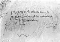
Here is a map that proves the Spanish were in Arizona on the 10th of April 1600. Source Cordoba, Spain records.
Expedición a la parte del río Colorado (1604-05).PNG
 

Last edited:
Why do you think the Records department of the University of Cordoba would release a fake document? Ink was used during that time on a quill pen. Just so you know that is the legend to the map, giving you compass directions and distances.
 

Last edited:
Why do you think the Records department of the University of Cordoba would release a fake document?

Not a document expert but the two levels of light and dark ink is a dead give away the document was altered at some point to me.

wrmickel1
 

Did you notice the lighter ink was done in 1727? 127 years after the map was drawn and then recorded in Spanish Archives in 1604-05. The Document experts would be able to tell you why the map was checked out of the archives and who signed for it. Only part of the actual map is upper left hand corner of the picture.
 

Last edited:
For those wondering the area the map depicts. The curve at the bottom of the legend is the Gulf of California. The box depicts the area covered by the larger map. above that is the compass heading of North.
Example is the area covered by the Expedition of 1600.
Map area.PNG
This proves also that Spain knew of the Colorado and Gila Rivers 100 years before Kino's Map.
 

Last edited:
Here is a map that proves the Spanish were in Arizona on the 10th of April 1600. Source Cordoba, Spain records.
View attachment 1496485

You've been misinformed. What you've posted is a photo of an inscription on rock made by Don Juan de Onate in 1605. It is located at Inscription Rock at the El Morro National Monument in New Mexico. The "map" is graffiti added later.
 

Last edited:
For those wondering the area the map depicts. The curve at the bottom of the legend is the Gulf of California. The box depicts the area covered by the larger map. above that is the compass heading of North.
Example is the area covered by the Expedition of 1600.
View attachment 1496510

This proves also that Spain knew of the Colorado and Gila Rivers 100 years before Kino's Map.

Columbus Sailed the ocean 1492, Under the Spanish Flag.

Spain was all over the Us by 1540,Kino came way way later.

wrmickel1
 

For those wondering the area the map depicts. The curve at the bottom of the legend is the Gulf of California. The box depicts the area covered by the larger map. above that is the compass heading of North.
Example is the area covered by the Expedition of 1600.
View attachment 1496510
This proves also that Spain knew of the Colorado and Gila Rivers 100 years before Kino's Map.

The planned rendezvous (just missed each other) between Diaz and Alarcon during the Coronado Expedition certainly shows the Spanish had knowledge of the Colorado River long before Kino.

Knowledge of the Gila River at that same time might have depended on the routes of Diaz, (I don't remember.) He certainly must have know of the intersection of the Gila and Colorado. I think his untimely death kept him from submitting his full report.

Gullum knows the history of the Gila River, sure he could remind us which Spaniard officially 'discovered' that river first? Did Coronado see the Gila, doubtful. Did Niza?
 

You've been misinformed. What you've posted is a photo of an inscription on rock made by Don Juan de Onate in 1605. It is located at Inscription Rock at the El Morro National Monument in New Mexico. The "map" is graffiti added later.

Shame on you sdcfia - how dare you let facts get in the way of a good story. :)
 

The planned rendezvous (just missed each other) between Diaz and Alarcon during the Coronado Expedition certainly shows the Spanish had knowledge of the Colorado River long before Kino.

Knowledge of the Gila River at that same time might have depended on the routes of Diaz, (I don't remember.) He certainly must have know of the intersection of the Gila and Colorado. I think his untimely death kept him from submitting his full report.

Gullum knows the history of the Gila River, sure he could remind us which Spaniard officially 'discovered' that river first? Did Coronado see the Gila, doubtful. Did Niza?

Coronado likely crossed the Gila about halfway between Duncan NM and Redrock NM. This website contradicts the usual dogma mapping out his 1540 route, but their argument is very strong, as they have recovered a number of 16th century Spanish artifacts at various stops on the route. http://www.chichilticale.com/1tierra.htm

Marcos de Niza is another story and still an enigmatic character. His behavior during the Coronado Expedition is baffling, but his 1539 trip is even more so. It's my opinion that Marcos first saw the Gila at the same place crossing mentioned above and followed the river upstream to today's Bear Creek, then likely up to today's Pinos Altos/Santa Rita mineralized region, just west of the Mimbres River. He was led by Estavanico, who had been in the same area a few years earlier with Cabeza de Vaca. Of course, I could be wrong.
 

Top Member Reactions

Users who are viewing this thread

Latest Discussions

Back
Top