Are these donuts frosted by any chance? If so, I'll take one.
you can have the frosted ones...but i get the chocolate donuts

Are these donuts frosted by any chance? If so, I'll take one.

you can have the frosted ones...but i get the chocolate donuts
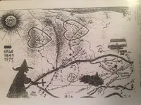
The circles or donuts are where the gold was milled
Previously I made this post:
DanB,
Is this a photo of the bend in the creek one mile due west of the Valencia Mine off the old Bumble Bee Road ?
Some people call that creek Poison Creek, others Sycamore creek but it actually was Turkey Creek in Pioneer (Peralta) days.
If it is, that is where the Peralta's ( Pedro and Miguel and Miguel's father) had their arrastras for working the gold they took out of the Valencia one mile to the east.
The Valencia was recorded at Prescott 1863-1864 and sold off to anglos by Pedro Peralta and the other Mexican owners. The records are in the old Yavapai County Recorders books.
I've been to the Valencia on several occasions and over where the arrastras were in the creek. This is one of the few places in Arizona where Peralta's are actually documented as having mined.
Matthew
DanB wrote: Yes it is.....the 2 donuts or circles are arastas... grinding stones.
I have been to the Valencia mine and have walked the one mile from the mine west to the creek where the arrastras were. In the days when Pablo, Pedro, Miguel Peralta worked the Valencia a dam was built across the creek.
You can see today where the ore was worked because the bedrock along the creek is worn away in places. Anyone who doesn't believe there were arrastras at that bend in the creek need only read the Prescott newspaper of the day which more than once references the mine and the arrastras in "Turkey Creek" one mile west of the mine. Floods washed away the dam which was rebuilt and washed away again.
I don't know how the Stone Maps fit this area if they do at all. I am not skilled at reading those maps so I leave that up to the experts. I don't have an opinion one way or the other.
Today that mine is known as the Gloryana. I had never heard the name "Portugese Bend" for that bend in the creek. I know there is a large placer operation just up creek from the bend called the Black Canyon Placers.
This valencia mine and site of the arrastras are very easy to get to. You can drive there in your car on a good paved road, park near the mine and walk the mile over to the bend in the creek.
Matthew


View attachment 1486676
somehiker,
The "Jesuit Treasure Map" is interesting because it fits the searches of Travis Tumlinson and his associates as well as Clarence O. Mitchell (Travis Marlowe).
I am worthless when it comes to deciphering these maps, I leave that task to those who actually understand the signs and symbols and how to read them.
My question is however, when and where did this "Jesuit Treasure Map" come into existence or become known to treasure hunters ?
Was it before or after the Peralta Stone Maps were "discovered" by Travis Tumlinson in circa 1949 ?
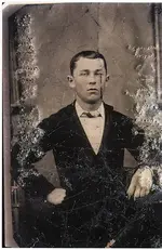
The name Das Luca is more than coincidentally the same name as the man involved with the tin type photograph of a young Jacob Waltz.
View attachment 1486679
Das Luca photo of young Jacob Waltz.
The name , Jean Paul Gagne is unknown to me and I understand Das Luca and Jean Paul Gagne are one and the same person. (?)
Is there anything you can fill in about this Jesuit Map, its origins, who Das Luca/JP Gagne might be and if this is the map the Tumlinson associates used to search the Superstitions ?
Matthew
 It should not be hard to prove the provenance if these specimens are from the same origin as those presented to the Royal Society of England...And if a person could do such a thing I am certain that the value of said specimen would increase greatly...That is if any of said specimens are still in existence...Furthermore the Platina is visible to the naked eye which should mean that this specimen would contain greater than 40+ ounces of Platina to the ton of ore...Though I believe it to be much much greater...Did I fail to mention that these are very SPECIAL RARE specimens...Some of you might ask...It there were over 40+ ounces of Platina per ton of ore...Why doesn't the fool just work it...My simple reply is that the mine has been lost to time...
In edited version plus 2 others
View attachment 1486714View attachment 1486715View attachment 1486716
Is there anything you can fill in about this Jesuit Map, its origins, who Das Luca/JP Gagne might be and if this is the map the Tumlinson associates used to search the Superstitions ?
Matthew
 ? Interbreeding, sides many of the Indian girls were quite pretty - such as our DIT>