The "Peralta" Stone Maps --- On Their Own

I am an old hat at this stuff, been here off and on since 2011.
sometimes the ridiculousness gets pretty bad and a long break is needed.
 

I am an old hat at this stuff, been here off and on since 2011.
sometimes the ridiculousness gets pretty bad and a long break is needed.


AAAAAAAAAAAAAAAAAAAAAAAAAmen!
 

Sarge

If you have found the cypher of the stone map trail , tell us : why the trail is carved on two stones instead one ?

I believe how the trail could been carved on a single stone . Who knows the answer , have found the EL TESORO DE LOS EGLESIA DE SANTA FE .


That is a point not many talk about. why 2 stones. when u figure it out . There is def a reason for it.
 

One of these days someone will come along with evidence that will prove beyond a shadow of a doubt that the PSM's are real and that they do lead to some place...As to where that place is...I will leave that up to ya'll to figure out...

Could they lead to a lost Platinum bearing Real de Minas...Who can say for certain...IF the proof is in the pudding and some of the ore that I have in my possession is platinum bearing...I just may be the one who has come along with said evidence of which I speak...Could I have stumbled upon a lost Platinum bearing Real de Minas that the King of Spain ordered closed...At which time he also ordered that all records of said Real's location be stricken from the records...Who can say???

Maybe one day I may be able to prove my claims...I am not certain IF I will ever be able to return to said location...But I still have a small amount of the ore collected from said mines...

Ed T:)
 

Last edited:
That is a point not many talk about. why 2 stones. when u figure it out . There is def a reason for it.

Doc I already explained it 2/3 years ago, The first part of the trail map is its own map, 231 is in the two maps, But the first map states 3=2 your standing on start for the first map and the second. The first map is the vault the second is the source, The Horse map is the Smelter. Silver mines to the North and the Priest is well, we will let that be for now. And the Heart and triangle is telling you 10 degrees off straight North to the west. But they did put a clever safety system into each map.

Now could Travis have done all this, No

Babymick1
 

Last edited:
Doc I already explained it 2/3 years ago, The first part of the trail map is its own map, 231 is in the two maps, But the first map states 3=2 your standing on start for the first map and the second. The first map is the vault the second is the source, The Horse map is the Smelter. Silver mines to the North and the Priest is well, we will let that be for now. And the Heart and triangle is telling you 10 degrees off straight North to the west. But they did put a clever safety system into each map.

Now could Travis have done all this, No

Babymick1

Babymick1

You wrote in the Horse stone map how silver mines are to the north . But the text in the map says how the Horse is grazing north of the river and shows the Horse below the river . Now , i'm little confused , where is the north ?
 

Babymick1

You wrote in the Horse stone map how silver mines are to the north . But the text in the map says how the Horse is grazing north of the river and shows the Horse below the river . Now , i'm little confused , where is the north ?


The 5 with the 4 dots around the region Markmar, The name of the river, Well let’s leave that out for now.

Wrmickel1
 

Babymick1

You wrote in the Horse stone map how silver mines are to the north . But the text in the map says how the Horse is grazing north of the river and shows the Horse below the river . Now , i'm little confused , where is the north ?


It's a very interesting puzzle, and the line with the "RIO" up and to the left of the horse's head is something that continues to stump me and has for a long time. I still can't make head or tail of it.

The location of the "Yo pasto al norte del rio" directly to the right of the horse is a clue as to the orientation and location of the horse itself. The tail end of the horse does face north. For a long time I assumed that the "pasto" had something to do with the nature of the horse, but then I realized that it was simply a clue as to the geography of the area that the horse is located in. It's an ideal place for grazing.

Yes, Agreed Sir

I’ve always stated the maps contain places to water sources, food, shelter, mines, Smelters, Crushers etc.
Everything needed to sustain life as you gather wealth for the church, Crown, and yourself.

babymick1
 

It's a very interesting puzzle, and the line with the "RIO" up and to the left of the horse's head is something that continues to stump me and has for a long time. I still can't make head or tail of it.

The location of the "Yo pasto al norte del rio" directly to the right of the horse is a clue as to the orientation and location of the horse itself. The tail end of the horse does face north. For a long time I assumed that the "pasto" had something to do with the nature of the horse, but then I realized that it was simply a clue as to the geography of the area that the horse is located in. It's an ideal place for grazing.

As i wrote in the past , IMO the line behind the " RIO " word from the Horse stone map is the same with the " R " line from the trail stone map . This line is not the same " RIO " with the word from the text . The " RIO " from the text is a river , but the line is something else . If one day you will find the Horse and you will look around , you will understand what the line represents .
Also , IMO , the place where the text is written on the map has nothing to do with the horse or the horse's tail orientation . The text only says where the horse landmark is located in regards with the river .
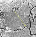

Total disagreement, The Rio and the R have no link to each other from the trail map to the horse map. Complete different meanings, Rio is not a river.

Wrmickel1
 

Total disagreement, The Rio and the R have no link to each other from the trail map to the horse map. Complete different meanings, Rio is not a river.

Wrmickel1

Of course have link each other . All the stone maps are for the same region , a mountainside .
 

Of course have link each other . All the stone maps are for the same region , a mountainside .

I was just stating the R has no relation to Rio, Markmar. The R is related to a King or Queen, And Rio a very old meaning for a Simiarid Plateau, Hardly a Mountain side. The word Rio For River is like a slang word used after 1502 when a fleet of ships turned to what they thought was the mouth of a river and crashed their ships on dry land.

Most everyone is trying to use modern day word meanings to a map made long before.

Must use the appropriate meaning of the words

Wrmickel1
 

Markmar

1847 would mostly be the last year of the operations in the area in question, later time frame accounts would be more of recovery and salvage of what was left there.

By best estimates from meanings on the maps I’d say start date to be somewhere between 1530 and 1540
just my thoughts on it based on key meanings of some symbols used.

Wrmickel1
 

As i wrote in the past , IMO the line behind the " RIO " word from the Horse stone map is the same with the " R " line from the trail stone map . This line is not the same " RIO " with the word from the text . The " RIO " from the text is a river , but the line is something else . If one day you will find the Horse and you will look around , you will understand what the line represents .
Also , IMO , the place where the text is written on the map has nothing to do with the horse or the horse's tail orientation . The text only says where the horse landmark is located in regards with the river .

The smooth, wavy line at the very top of the UTS is the profile of the los some(r)o montana as described on one of the Stone Crosses, and is the Fornix or "arch" on the CP.

In contrast, the line above the RIO on the upper left of the horse side of the H/P stone is squiggly. The letter R is furthermore not similar to the one on the UTS. That one of the legs of the R is long and points to the horse itself, suggests that either crossing the river or following it leads to the horse. But which river? And how? And what do the five dots represent? And the two circles and buried symbol? These are some of the questions I continue to ruminate on.

And if you have been paying attention to anything posted on this board, there is no horse for me to "find." It was already found, a long time ago. And there is absolutely no question at this point, that it is the same horse as the one depicted on the Stone Maps.
 

Not really to the horse itself...but rather-->>

some(R)o montana.jpg

The Somero Montana.
From whence that same Horse began or has still to begin his journey.
And yes....there IS an arch through which a passage may be found.

And for Mick......if the R means Royalty, then maybe this is what you should be looking for ...

100_1084 crown.jpg

looks like a European style Crown ??
 

Top Member Reactions

Users who are viewing this thread

Back
Top