The "Peralta" Stone Maps --- On Their Own

Re: The "Peralta" Stone Maps --- On Their Own

somehiker said:
Morning Joe:

Is there a topo map which has "Caballo Ojo" or "Eye Of The Horse" named on it ?
Can't find "Caballo Ojo" written on any of the Stone Maps either.
Not even on the Stone Crosses or Latin Heart.
Or Abe Ried's Cursum Perficio Rock ,for that matter.
If the hole in Palomino Mtn. was at one end or the other,I could see it being called "Eye of the Horse"...otherwise it sounds more like a red herring hint.
The Aylors had their camp at the bottom of Palomino,which they called "Caballo Camp" (maybe they rode horses?) ,and they spent a fair bit of time digging holes on his Palomino claim below the arch.So Chuck must have thought that the mountain contained gold or something.
Now,if he had spelled the name as "Cobollo",that would have been a "hint".
A good article by Tom K.....http://www.ajpl.org/aj/superstition/stories/The Aylors.pdf
Doesn't mention Tumlinson,stone maps,or DeGrazia though.
If anyone was able to write about such a connection,I would think Tom could.
He has already researched and written about what he knows in several articles.

For me, if what could be a trail was carved or even scratched,from the Horse's eye to somewhere else on the H/P stone,I would only then consider it a possible starting point.
The carved line beginning at the Horse's nose would make a more likely jump off point.
Did Aylor have a hint about the Horse's nose ? Like maybe "the nose knows" or "heh lady,that ain't no banana ! That's my nose !"
Hahchchchchchah :laughing7:

Regards:Wayne

Wayne,

"Since the arch on Palomino Mountain doesn't have a name, we wanted to identify if for easy reference in our hike descriptions. Tom Kollenborn suggested Aylor's Arch which we think is an appropriate name. He also said some story tellers call it the Eye of the Horse or Caballo Ojo."

I have read Tom's article a number of times, but appreciate the suggestion. I agree that if anyone were to make such a connection, it would be Tom. It's true that the other end of the horse might have been a more appropriate place to start, and while Tom doesn't write about that........there seems to be plenty of them around these days. :wink:

Thanks for pointing out my inadequate attempts to make logical connections in my theories. Keeps me on my toes. :D

Take care,

Joe
 

Re: The "Peralta" Stone Maps --- On Their Own

Joe:
No problem.It's part and parcel to what keeps our juices flowing. :wink:
And I have read many of Jack's hike descriptions and historical tidbits.
His original Hikers Guide is still the only publication about the range which I have on my bookshelf.My reasons for this,I have stated before.
Historical bits and pieces are important to my beliefs,just as they are to yours,and Tom has,over the years contributed many.
While you may see a strong connection between Aylor and the Stone maps,based on some of these bits,I in turn see them as tenuous at best.
Aside from that,we do seem, too often, to have a clear view from the cart....of the wrong end of the horse. ::)

Best:Wayne
 

Re: The "Peralta" Stone Maps --- On Their Own

Real de Tayopa Tropical Tramp said:
of the wrong end of the horse" Is it?

Don Jose de La Mancha

All depends on your perspective,Don Jose.
Why ?
Do you resemble that remark? :tongue3: ;D ;D
 

Re: The "Peralta" Stone Maps --- On Their Own

Wayne,

"While you may see a strong connection between Aylor and the Stone maps,based on some of these bits,I in turn see them as tenuous at best."

As a Dutch Hunter, I should think that everything you see, or have posted here, is "tenuous at best". I have posted a number of facts and theories that make a tenuous, or better, connection between a number of LDM players and the Stone Maps. Many people, especially those who have their own convictions about the maps, find my map to be tenuous and less than believable.

Even though it's possible that I may have found your posts and pictures less than convincing, not having all the answers or facts that you may have, as a friend, I will normally give you the benifit of the doubt. Who knows what you have seen that makes you believe what you do. :dontknow:

Since you seldom, if ever, make statements of a positive conviction, there is little to debate. I believe in what I post enough to invite debate. Sometimes that's good, sometimes not so good. :dontknow:

Take care,

Joe
 

Re: The "Peralta" Stone Maps --- On Their Own

Joe:
I don't know if I would or could be considered by anyone else,a "Dutch Hunter".Like yourself,I have never set out with the goal of finding the LDM.
Tenuous evidence,in the case of the Dutchman's lode,therefore has no bearing upon my convictions.
The Stone Maps for me,are a far more interesting topic as are the multitude of solutions presented by others,including yourself.
As friends,we should never feel obligated to withhold comment or critique on each piece of evidence presented,be it photo,map or written observation.
There is seldom anything to be gained by such accorded "benefit of the doubt" when it comes to such a complicated and popular topic.There have been numerous occasions over the years where you have offered opinions and suggestions related to photos and comments which I have posted,in many cases prompting vigorous debate from many sources and links to further information, such as that provided by Gary and Carol Cundiff.Even that material has lead to further and fresh debate regarding the history of the Stone Maps.Perception has a great deal to do with conviction.It also has a bearing on what others may see as a lack of same.

Regards:Wayne
 

Re: The "Peralta" Stone Maps --- On Their Own

i have been rereading the replies between you and joe ...

i have a few points i would like to make ...

one it really has nothing to do with being a dutch hunter what so ever .. i did not beleive i was a dutch hunter and i still do not think i am .. so lableing you or anyone a dutch hunter is up to debate ..

the stones prove one thing very clear .. they can be read in many ways and translated in thousands of ways maybe 10's of thousands ...

but i can tell you IMHO there is only one correct translations...

the prove is in the discovery of the real translations . the rest of the debate is useless ...

the hourse could be a focus of some dream by a totally own known sorce for all you know ...

the facts comes back to the correct translations

if you do or dont agree , be at the rendenous on the 21st by 8:30 ..i will prove my point clearly ...

i have watched the debates for many years now and the same thing over and over

the lack of a clear and correct translation ..

the stones are interesting for one reason above all other reason .. they reflect a vast wisdom of the mts and the skills of who made them .. beyond that there is one person that has ever translated the stones correctly that i know of ...

the debate is not has he correctly translated the stones .. the debate is when will the transaltion become public.

IMHO next month on the 21st

i respect your hard work and debate it is easy to offence when topics are debated to the bitter end ..


thats no longer an issue to me .. the ignornce that was shared by members of this site the other day reflect the lack of open mindness to the fact the stones can be translated by anyone with the right skills and training ..shows the mentally of the true dutch hunter IMHO ...

other then what i can carry on my back . i want nothing to do with the legend or being known as a dutch hunter. it would be degrading after knowning what and who they are ... ...its a shame it never had to get to this point IMHO ...i can only hope the mine is looted and the left for useless ..reflecting the true nature of the treasure hunter and the dutch hunter ..

good luck
 

Re: The "Peralta" Stone Maps --- On Their Own

Over the years, some people has said that the Stone Maps aren't necessarily showing the Superstitions, but could match closely to many other places, in and out of Arizona.

I like Joe's trail, because of certain reasons already stated a couple of times.

But, just to keep an open mind, here is another possibility---


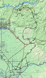
Supers Trail Overlay.jpg


Apparently several people have thought that the lowest line on the Trail Maps represents the Gila River. This overlay does cross the Gila. And the way it wraps around the mountains, before entering the Supers, is interesting.

If one assumes that the Stone Maps are meant to be symbolically directional, rather than precision topographical charts, I think this version could be possible.

But aligning the dotted trail with actual landscape which would allow travel, and with landmarks, would be necessary, in order to see how much would reasonably match up.

:coffee2:
 

Re: The "Peralta" Stone Maps --- On Their Own

cool charting EE .. i am shocked .it fits well there ..
 

Re: The "Peralta" Stone Maps --- On Their Own

Real de Tayopa Tropical Tramp said:
HI, curious, but it looks to me as if that trail could have been shortened by at least 1/2 the travel distance and time ???

Don Jose de La Mancha


I think the X's may be water holes.
 

Re: The "Peralta" Stone Maps --- On Their Own

EE THr said:
Real de Tayopa Tropical Tramp said:
HI, curious, but it looks to me as if that trail could have been shortened by at least 1/2 the travel distance and time ???

Don Jose de La Mancha


I think the X's may be water holes.

EE,

Nice theory. Lot's of folks can fit the map in many places. If the Xs were water holes, shouldn't the trail go through them, rather than skirt them? For where your map ends up, I should think they would have gone around the west end of the Superstitions.

No right or wrong answers at this point.

Take care,

Joe
 

Re: The "Peralta" Stone Maps --- On Their Own

Joe---

There are some lakes, between the trail and the middle X. There is also at least one approximately near the bottom X. If the trail is not precisely to scale (and if it's "old" I would assume that it's not), then it could be applicable. On the top X, I don't know what water it would be referring to.

Since water was marked by X's on the "Unnamed" copy of Julia's map, and since it seems possibly related due to the similarity of the "Needle," I think there may be reason to suspect that the X's refer to water.

As to going around the West end of the Supers, I think the same thing every time I see any reference to entering from the South end, from the supposed Peralta instructions, to the legends, to Julia's map. (Except for the references to getting supplies from the South, and the wounded guy who escaped to the South, because these do make some sense, if true.)

Maybe the map maker(s) figured it's better to duck into the mountains as soon as they arrived in the area, rather than parading themselves out in the open by going around the West end?

The trail I posted over the Supers map is an overlay tracing of the Stone Trail Maps, un-altered. The problem with it, even if the suggested overlay match were true, is that it is not accurate enough to actually find the end location. It could be off by several canyons. I've always thought that it seems like there is another part to the Stone Maps, which is missing. Of course, a monumented trail would help in that regard. 8)
 

Re: The "Peralta" Stone Maps --- On Their Own

EE,

There is not much that could change my mind about the layout of the Stone Maps. There are just too many points that can be checked against each other for coincidence. Most of the map is pretty precise as well as being very, very close to scale.

I am still waiting for someone to show a map that matches better than mine. While I found no gold, there is always the possibility that the maps don't actually lead to a treasure. It's also possible that I just couldn't find any gold/treasure.

The first "X" coming down off the main mountain is a cave. (empty) The second "X" is a sealed mine up on the ridge between West and East Boulder Canyon's. It has a modern day marker in front of it.
It should be fairly easy to find.......Short, nontechnical climb out of West Boulder. I never saw the mine, but one of my team members found it and described it to me over a two-way radio.

I have not been back into the mountains since that trip.

Take care,

Joe
 

Re: The "Peralta" Stone Maps --- On Their Own

cactusjumper said:
I am still waiting for someone to show a map that matches better than mine.


I have doubts that there will ever be one that matches better than yours.

I only posted that map above as one of many possibilities in general.

One thing I am curious about, though, is that your map doesn't show all of the Stone Maps markings. Especially the horizontal line on the bottom, which some think is the Gila River, as in the suggestion above. Also, do you have any idea about the numbers on the Stone Maps? Especially on the Trail Maps? And that thing that looks like half of a rising (or setting) sun? And that gosh darned "needle" that is so similar to the Julia map copy?

:icon_scratch:
 

Re: The "Peralta" Stone Maps --- On Their Own

EE,

That needle thing sure does raise some questions about Julias map.
Speaking of maps. The Ruth/Gonzales map, the botttom 1/3 of the map is blank and this has always struck me as odd, I appologize if this has already been gone over but why would the bottom 1/3 be blank like that, what have I missed?

Bill
 

Re: The "Peralta" Stone Maps --- On Their Own

EE THr said:
cactusjumper said:
I am still waiting for someone to show a map that matches better than mine.


I have doubts that there will ever be one that matches better than yours.

I only posted that map above as one of many possibilities in general.

One thing I am curious about, though, is that your map doesn't show all of the Stone Maps markings. Especially the horizontal line on the bottom, which some think is the Gila River, as in the suggestion above. Also, do you have any idea about the numbers on the Stone Maps? Especially on the Trail Maps? And that thing that looks like half of a rising (or setting) sun? And that gosh darned "needle" that is so similar to the Julia map copy?

:icon_scratch:

EE,

My very first thought when I saw that stone, was that the line you are talking about was a rough outline of the main mountain. It followed that the bent arrow was a canyon taking you to the top of the ridgeline.

Once I determined that, I pulled out a topo' and the rest of the trail map flowed from there. Many people don't seem to see that the way that I do, but in the end......it works. If you know all of the stories, they support that theory.

The Bicknell/Ruth directions, Harry LaFrance's cave of gold bars and a few others all bolster my viewpoint. When you consider the two monuments my brother and I found, not long after I figured out the maps, and the heart at the end of the trail, right where I placed it on the topo' over 40 years before I actually found it.......well, you start to get the picture.

On the other hand, what the #e!! do I know. :dontknow:

Take care,

Joe
 

Re: The "Peralta" Stone Maps --- On Their Own

cactusjumper said:
EE,

My very first thought when I saw that stone, was that the line you are talking about was a rough outline of the main mountain. It followed that the bent arrow was a canyon taking you to the top of the ridgeline.


Ahhhhh! Now I get it! Quite a while ago, when people were talking about the Stone Maps matching up to a topo, I pictured in my mind that all the lines represented overhead views. So I couldn't figure how that bottom line would match anything except a river or creek.

But you mean it's a silhouette of the mountians on the Southern end, right?
 

Top Member Reactions

Users who are viewing this thread

Back
Top