Re: The "Peralta" Stone Maps --- On Their Own
Well, I wanted to keep the Peralta Stones and the LDM separate, but the worst has happened.
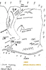
I was staring at pictures posted recently of the Stone Maps, and I got to looking at the "trail." I had always thought that the bottom wiggly line, on the bottom Trail Stone, was the Gila River, and the dotted "trail" line represented a path across the river, around the mountains below the Superstitions, over to the Fremont pass or somewhere around there, and upward into the Supers.
Then I saw CJ's trail map, and it's very convincing.
But, as I stared at the Trail Stones today, that trail reminded me of something. I thought it might be one of the paper maps from my other thread, which is just on the LDM theories. I purposely left out any references to the Stones (except for one post where I showed the similarity of the needle outline on the Stones to the one on a map).
But now I've seen a couple of things which could link the two, and I just have to say what they are.
It's the general shape of the Stones "trail."
It starts off going upward, somewhat to the right, makes a loop to the left and back, then goes up a little ways and hooks to the left.
So, I looked through my hard drive, and guess what?---

(This map appears to be a rough copy of the Julia Thomas map, only with North and South reversed, so that in this map, North is at the top.)
The trail on this paper map is not in the exact proportions as on the Trail Stones, but it takes all the same turns. Except that instead of stopping after the top "hook" to the left, this map continues upward a little ways, and ends with a similar circle, with a dot in the middle. This would make, what I first thought was the Gila River, on the Trail Stones, instead the lower edge of the Supers.
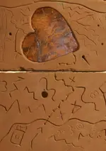
Here are the Trail Stones, to compare this with---

OK, it seems like stretching a coincidence, right? But wait---there's more.
Look at where the "X's" are located on both this "unnamed" and the Trail Stone maps. If you omit the one on the paper map, which says "Maybe Water," the other three are approximate matches to the "X" locations on the Trail Stones. And the triangle with the line coming out, on the Stones, is about where the "Maybe Water" "X" is on the paper map (what that might mean, I don't know).
But wait---there's even more.
Look at where the "teepee" looking symbol is on the Trail Map, then look at what's in that area on the original Julia map---
(Remember, the top of this one is South.)

And then, of course, there is the same needle on the Stone Heart, that appears on the "Unnamed" map---

?