The "Peralta" Stone Maps --- On Their Own

And speaking of the "Needle" symbol, why is it put so far North, just below the Salt River, on the Heart Stone?

View attachment 54966


On the original (or so it says) Julia Thomas map, Weaver's Needle is represented far to the North also. Note that North is at the bottom of Julia's original map, as shown below.

View attachment 549394


Julia has it labeled "Weavers Needle," and the "Unnamed" copy only says "Needle." But you can tell from the position of both needles, relative to the other landmarks on these two maps, that they are intended to represent the same needle.

With the symbol on the Heart Stone, appearing to be the same landmark as the one labeled "Weaver's Needle" on the Julia maps, and with all three showing it much further North, proportionally, than it should be, is that indicative that these three maps are somehow related?

Why else would these maps have these similarities?

:dontknow:
bump
 

Last edited:
somehiker,

There is one published report that describes a "distant mountain top" being lost during the earthquake. This was observed during some type of parade or military review at Ft. McDowell. They (soldiers) even mounted an expedition to the site. I am not sure if Weaver can be seen from FM or not (22 miles away). Obviously, if not, this might be where that "story" began and would essentially eliminate Weavers.

Photo - Weaver's needle and a saguaro - Pictures Of Fort Mcdowell, Arizona, United States - Travel Photos :: AllTravels :: Anywhere You Want To Go ::.

Although this shot is not from the parade ground itself, it's probably representative of the view.
I think Matthew Roberts once posted a photo of Weavers from the old fort itself.
Or Wayne Tuttle perhaps.
 

Hal

I believe the " peak " from the stone trail heart is the same with the " CACUMEN " from the stone Latin heart .
 

After Julia Thomas ran out of the funds that she and the Petraches used to fund their search for Waltz' caches and mine, she began to sell copies of a map she said was drawn by Jacob....or perhaps drawn by her with Waltz' assistance. A number of these maps have been published, each with slight differences. Maybe because they were hand drawn copies. She also IMO, may have kept the original, intending to undergo another search some day if someone else didn't get to it first. With that in mind, I think it possible that each copy she sold may have been close, but not exactly the same as the original, with Julia keeping at least one key feature,name or location to herself.....perhaps because it revealed the exact location of the cache of ore for example. After all, it was the cache which Jacob intended Julia to have.

http://www.treasurenet.com/forums/attachment.php?attachmentid=54966

Treasure Map Facsimile

https://books.google.ca/books?id=KV...onepage&q=burbridge map/ peralta mines&f=true

Last link does not work. Were you intending to link to Burbridge's "Minas Del Oro" map?
 

Last link does not work. Were you intending to link to Burbridge's "Minas Del Oro" map?

No....... Page 116 of Jane Eppinga's book "Apache Junction and the Superstition Mountains"

I've tested the link...my browser takes me direct to that page, with another version of Julia's map.
 

Because of places like these, and their proximity to other things shown on Julia's map, I believe that map, especially the "original" version, was fairly accurate.
At least to someone like Jacob at the time.

A needle, a "rock horse", and a place with a heavily "mineralized" hanging wall of quartz.

View attachment 1256179 View attachment 1256181 View attachment 1256182
 

Last edited:
Her Map was "Wacky".

If you want to find the Dutchman's Mine you have to go back before the Dutchman was there and presume his story about the Mexican Miners was true. If that's true than the Peralta's were possibly the Miners. That means they prospected. It's well known they cover up their workings too make it look "Natural". Today we have technology that can find these area's of disturbed soils with out the mess of exploration and zero in on the area looking for other clues. Clues of the Spanish / Mexican mining. Pre-early eighteen hundreds it was Spanish only. Which probably never changed that much except for the Royal Fifth. De Re Metallica was the only method used early on. later years they used other methods. Time has a way of covering things up. Do a shallow soil surface with a


"AgriSpec VisNIR Spectroradiometer"

https://www.researchgate.net/publication/262726447_New_Technologies_in_Field_Soil_Survey

I can't believe they're using it for the EPA so those Federal Bozo's can document our land and mineral worth!


Gee Bill. If by "wacky", ya mean it's got no witches or warlocks hiding in the shadows, some turtles or even flyin squirrels showing you where the nuts are, then I suppose so.
But hey, I've seen turtles too..... this one being the best of the bunch.

View attachment 100_0590 Tortois.bmp

I don't know what the Peraltas would have done, with signal fires blazin all around and pissed off Apaches havin a big hoe-down.
Do ya think they woulda said to themselves....hey, let's cover everything up, so nobody, including these Injuns, will ever know what we was doin out here....?
Or do ya think they woulda got the hell outa Dodge, hopin to save their topknots instead ?
Me, just bein one of them "vacation" guys from outa state, and in my case outa the country, well I'm more inclined to believe the latter as what they did,.
A genuine t-hunter like yerself might say option one, drag a truckload of fancy gadgets up into them mountains, and start looking for "covered up" mines.
Whereas I'll just keep reading up on this stuff, sortin it out, and keepin my eyes open whenever I'm out there, Especially up high, where it's all broken up and hardly anyone goes.
Sides, it's a whole lot easier to get there if I'm packin light, looking mainly for what don't take a pick or shovel just to know what's there.
Can't say I care all that much about the LDM, true or false, and I'm not gonna spend a lot of time looking for it. But it would be kinda neat to find an old mine like that, wouldn't it ?
Or an ancient ruin in a cave, when you wasn't even lookin for Waltz's motherlode......right?

View attachment two room.bmp
 

Last edited:
Thanks for the assistances- I was able to find that page elsewhere. Not sure why my browser is currently at war with this website, but hopefully I'll be able to get it resolved sooner or later.
 

What I meant was it's obviously a drawing for sale and not a true indication of Waltz's last words. If it was an indication she would have started looking from there instead of the other end of the range. She was not a Warlock....Just an Ice cream soda jerk.

The Turtles are real you have a nice one there. And it's good keeping your eyes open for anything with an open mind. Those gadgets can be used by airplane so no need to drag them along.

Keeping with an open mind that turtle has quite a phallus.

Must be looking at another one in H.E.A.T. Could be a big Hoe Down?

You should stay in state more often so you can find more stiff competition...with turtles that is.


Gee Bill. If by "wacky", ya mean it's got no witches or warlocks hiding in the shadows, some turtles or even flyin squirrels showing you where the nuts are, then I suppose so.
But hey, I've seen turtles too..... this one being the best of the bunch.

View attachment 1256323

I don't know what the Peraltas would have done, with signal fires blazin all around and pissed off Apaches havin a big hoe-down.
Do ya think they woulda said to themselves....hey, let's cover everything up, so nobody, including these Injuns, will ever know what we was doin out here....?
Or do ya think they woulda got the hell outa Dodge, hopin to save their topknots instead ?
Me, just bein one of them "vacation" guys from outa state, and in my case outa the country, well I'm more inclined to believe the latter as what they did,.
A genuine t-hunter like yerself might say option one, drag a truckload of fancy gadgets up into them mountains, and start looking for "covered up" mines.
Whereas I'll just keep reading up on this stuff, sortin it out, and keepin my eyes open whenever I'm out there, Especially up high, where it's all broken up and hardly anyone goes.
Sides, it's a whole lot easier to get there if I'm packin light, looking mainly for what don't take a pick or shovel just to know what's there.
Can't say I care all that much about the LDM, true or false, and I'm not gonna spend a lot of time looking for it. But it would be kinda neat to find an old mine like that, wouldn't it ?
Or an ancient ruin in a cave, when you wasn't even lookin for Waltz's motherlode......right?

View attachment 1256329
 

What I meant was it's obviously a drawing for sale and not a true indication of Waltz's last words. If it was an indication she would have started looking from there instead of the other end of the range. She was not a Warlock....Just an Ice cream soda jerk.

The Turtles are real you have a nice one there. And it's good keeping your eyes open for anything with an open mind. Those gadgets can be used by airplane so no need to drag them along.

Keeping with an open mind that turtle has quite a phallus.

Must be looking at another one in H.E.A.T. Could be a big Hoe Down?

You should stay in state more often so you can find more stiff competition...with turtles that is.

Bill,
I am still laughing you old terrapin.
 

Gee Bill. If by "wacky", ya mean it's got no witches or warlocks hiding in the shadows, some turtles or even flyin squirrels showing you where the nuts are, then I suppose so.
But hey, I've seen turtles too..... this one being the best of the bunch.

View attachment 1256323


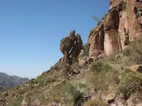
How do you like this one? Wonder what he's peeking at up there above him?

peering turtle.jpg
 

How do you like this one? Wonder what he's peeking at up there above him?

View attachment 1256459


Nice photo! What's really interesting is right under where the Turtles Phallus would be is an interesting sun created Birds head with a shadow "7" in the middle of the sun sign. It's pointing up to a protected campsite maybe with water. Also it should point to other symbols just out of the photo. You'll need to go up there and see if there's any mini maps or other bird, X, heart, door symbols leading somewhere. Definitely a Walkers Witchy poo Trail!
 

Top Member Reactions

Users who are viewing this thread

Back
Top