The Lost Doc Thorne Mine - was it the same mine of Jacob Waltz?

Joe

First , I want to opologize to the readers because I want to return to Fish/Peralta map , but I don't like to leave something which I can to explain , unexplained .
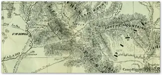
In one link about Fish map which posted Wayne for me before two days , you wrote how the mine is in Black Top Mesa . You are wrong and all the others who have believed this . Look to the map . The Black Top would be little NW from the Weaver's Needle , and the " Mesa Negra " is little NE . The author was writing about Black Mountain , and the mine is between " El Sombrero " and " Mesa Negra " ( Black Mountain ) .
Is not very hard to read a map just to see the details .

View attachment 904191

Marius,

I'm sure that everyone here is more familiar with that area, Black Top Mesa and the Fish Map than I am. I will leave the subject to the experts.

Good luck,

Joe Ribaudo
 

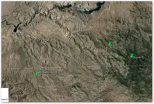
I overlaid the map onto google earth. The green markers are the 2 mine locations in relation to weavers needle. The mine locations are as close as I could get being that the salt river is a little different on the map than it is on google earth.
 

Attachments

  • Arizona-Gold-Mines-1865.png
    Arizona-Gold-Mines-1865.png
    342.5 KB · Views: 186
  • weavers.png
    weavers.png
    499.5 KB · Views: 236
Marius,

I'm sure that everyone here is more familiar with that area, Black Top Mesa and the Fish Map than I am. I will leave the subject to the experts.

Good luck,

Joe Ribaudo

I have to respectfully disagree with you on this one Joe, I sure do not know more about Blacktop Mesa and the Fish map than you.

Please do continue,
Roy
 

I overlaid the map onto google earth. The green markers are the 2 mine locations in relation to weavers needle. The mine locations are as close as I could get being that the salt river is a little different on the map than it is on google earth.

chlsburns:

The areas you seem to be trying to match are far apart. The two "+" marks on the 1865 map are situated approximately 40 miles east of where you have marked "Dutch 1/2" on your G/E view. They are between Pinal Creek and the Rio San Carlos on the 1865 map, and south east of the Tonto Basin. A search of some of the old mining claim maps may show who they belonged to and what was mined there. But they are well outside the Superstions.

Regards:SH.

SH you are right about that! It's not so easy to overlay maps on GE. The map is also dated about 20 years before the LDM.
 

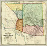
I attached the whole map. Maybe someone else can overlay onto GE? I had to make it smaller to upload it but it's still large. When you click the thumbnail to view the pic click on the pic again to see it full size.
 

Attachments

  • Arizona-Gold-Map-s.jpg
    Arizona-Gold-Map-s.jpg
    1.3 MB · Views: 304
Last edited:
chlsbrns

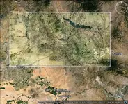
The map is not so accurate , but I made an overlay for you

Map.jpg
 

first...any attempt to overlay an antique map of the southwest over that of google earth is problematic.

while cartography was an advanced art at the time, it still was no way near the accuracy of google earth or GPS systems.

I have an old map compiled from several older maps...shows the verde river running due north from the salt....try fixing that to a modern compellation.
even the four corners is off some miles..

They had a hard time with longitude before they had access to a telegraph.
 

chlsbrns

The map is not so accurate , but I made an overlay for you

View attachment 904824

Thanks Marius. I was flying around GE near my original overlay and saw some steep cliffs that looked like they had mines cut into them. I thought that the story was that the Doc could see weavers needle from the location and that the Doc was at the bottom of a steep overhanging cliff. How could weavers needle be visible from the bottom of a steep overhanging cliff?
 

Thanks Marius. I was flying around GE near my original overlay and saw some steep cliffs that looked like they had mines cut into them. I thought that the story was that the Doc could see weavers needle from the location and that the Doc was at the bottom of a steep overhanging cliff. How could weavers needle be visible from the bottom of a steep overhanging cliff?

chlsbrns

I believe how is impossible to see a mine shaft on GE . GE is only to compare a location with a map and to ensure an investigation . If the location in GE fit more of 90% with the map , you are in the right region .
Now about Doc Thorne . I believe , how a closer to the reality version of the story is , when Doc didn't see the Weaver's Needle but only the Four Peaks . About the steep tributary canyon we have told some pages before . Read the thread from the beginning to " catch " the sense .
 

Last edited:
Hi Springfield: Latitude is a simple factor - angle measurement. Longitude requires an accurate clock or time measuring device, A 'noon day shot' can be substituted satisfactorily for most uses, but not for precise Cartography.

In WW-2 I was lucky to get within 1/2 a mile, today they are accurate to inches.

So a pore ole effectively uneducated prospector, prob. will be no closer than say 1 mile from a prominent mark. . except in extremely rough ground. So much for the other yarns on lost mines, placers, etc.

One days travel in open country will vary according to your animals, even you. and time of the year.

Don Jose de La Mancha

p.s. Marius, Top Sat work can pick up the no of ticks on a jack rabbits ears, but it "IS" expensive. Google is simply not set up for that, except for a bit more precision in centers of interest.
 

Last edited:
Last edited:
Marius:

You are still a long way off with your overlay.
Globe....shown with the red circle is on Pinal Creek at approx the place where I have marked it.

View attachment 904889


Here is an 1895 map which shows both Globe and the San Carlos Apache Res.
It also has Superstition Mountain labeled as we know it.

1895 Arizona Map Addendum

Wayne

As Springfield wrote , in that era they had trouble with longitude . I fit the distance from the junctions of the rivers with Ft. Mc Dowell and the first ranges South of these . To fit Ft . McDowell and Globe in this map , the map would be like this


Map2.jpg
 

Last edited:
This is what I found from Wikipedia after searching google with the search "Top of the world, Az".
The highlighted text does not contain links.

Eight miles west of Miami is a divide between Miami and Superior at the 4,600-foot (1,400 m) level. This area is known as the Pinal Ranch or sometimes it is called the Top-of-the-World. It derives its Indian name from the Pinal Apaches or "pine groves in the mountains."

The site was abandoned in 1871 by the army one month after being named Camp Pinal. The troops started their mule trail at "Infantry Camp" at the foot of Picket Post and then extended it into Picket Post Creek (later called Queen Creek). The trail then crossed Devil's Canyon (named by the troops) and halted at a post they intended to build in what was then called "Mason's Valley" (later, Camp Pinal). By April 1871 the mule trail and post were both completed and General Stoneman planned on making Camp Pinal his headquarters, but the project was abandoned after General George Crook replaced General Stoneman because of the Camp Grant Massacre of April 1871. By August of that year General Crook abandoned the post, and only the mule trail was left to indicate the intended ambitious presence of U.S. soldiers.
The old Craig Ranch was built at the site of Camp Pinal. The ranch was begun about 1874 by a Mr. Irion and the Craig family, even before the town of Globe was settled. Over the years the ranch house was improved upon, and it remained in the Craig family until the about the 1970s. The ranch house is still in good condition, in spite of its 100+ years.
The Top-of-the-World was a dance hall started in the 1920s along the old highway east of the Pinal Ranch. This area was settled by Robert A. Irion in 1878. His stepson Dudly Craig continued the ranching tradition in the area after Irion's death.

still no word of mason.
 

Last edited:
The Doc Thorn story has several different versions - the reference to seeing Weavers Needle or a pointed peak that I can recall was that he saw it while he was riding back to the Apache camp; that he mentioned it to the Apaches and they laughed about it, as he had not been taken SO far while blindfolded as the time made it seem.

I would suggest reading some of the different versions, not sure how many are online but two are in books by John D. Mitchell, Lost Mines and Buried Treasures along the Old Frontier, and Lost Mines of the Great Southwest, among many. I don't know of any book which is solely about the Doc Thorn mine however.

Good luck and good hunting to you all, I hope you find the treasures that you seek.
Oroblanco
 

Somehiker, this is what yo are looking for and I have posted a link to google books.
This book is called Arizona Place Names

Bookmark this page or save it to your library if you are subscribed to google books. This has a lot of the old names and where they came from.
And co-ordinates or location of the proper place.

This is where Masons Valley Came from.
North side of Pinal mountains about 10 miles from Hutton Peak.Old military outpost of camp pinal. Named perhaps after Col. Julius W Mason, 5th us Calvary, operating with Crook in this region from 1871-73.
Possibly from Charles G Mason one of the discoverers of the silver king.
 

Superstitions are not even on the map in post #166.
If Massons Valley is top of the world.
 

Somehiker, this is what yo are looking for and I have posted a link to google books.
This book is called Arizona Place Names

Bookmark this page or save it to your library if you are subscribed to google books. This has a lot of the old names and where they came from.
And co-ordinates or location of the proper place.

This is where Masons Valley Came from.
North side of Pinal mountains about 10 miles from Hutton Peak.Old military outpost of camp pinal. Named perhaps after Col. Julius W Mason, 5th us Calvary, operating with Crook in this region from 1871-73.
Possibly from Charles G Mason one of the discoverers of the silver king.

Done...and thanks for the link.

Pretty sure the Sups are where I have marked it on the map

View attachment globe.bmp
 

Last edited:

Top Member Reactions

Users who are viewing this thread

Back
Top