This is a pic looking at the Ledge, the orange dots are the Mexican foot trail up the ledge, the red dots are the Dutchman Mule trail to the South end of the ledge and tunnel entrance. The blue arrow points to a 'waterfall', water runoff from the funnel shaped pit, and the 'wash'-below the mine(green arrow).
View attachment 2063871
You pass between the cliff wall and this pillar-drop off to the right..
The Dutchman advised 'the vein ran 400 ft down/across the mtn/ledge', and when you round the corner to enter the tunnel, the vein of rose quartz exposed has been pick axed, everywhere.
View attachment 2063884These are pics entering the tunnel, going up the 'tunnel'(if cleared of brush an easy trail for pack mules), and looking back down from ledge top.. This Tunnel is Awesome!
View attachment 2063885
View attachment 2063886
View attachment 2063887On top of the ledge from the tunnel, there are 2 long rocks. Between them is a grassy area and a bush. Just my opinion, based on the clues and location, I believe this is the spot the Dutchman buried his partner. This is South of the mine.
View attachment 2063892
There are a couple sketch maps of the site drawn by a Mexican miner. This is a google pic coming into Peters canyon on the Mexican miners trail heading North to the site.
View attachment 2063969
View attachment 2063970
View attachment 2063971
This is looking down into the funnel shaped pit from the South peninsula, after you exit the tunnel. The red spots are the Dutchman trail down and entering from the side. The orange dots are the Mexican miners trail up the ledge on the North side foot trail.
View attachment 2063972
About 1/2 way up the ledge on the Mexican foot trail you pass this 'face' looking down the canyon.
View attachment 2063973
View attachment 2063974
Once on the ledge, there are 2 200 ft long peninsulas jutting West into the canyon, between them is the 'funnel shapped pit'. Both peninsula ends 'curve' in at the bottom, forming a funnel.
The trail goes around the pit, down the North peninsula, and at the bottom you enter to the mine from the side. You must go up to go down, and enter from the side.
This pic is from the North peninsula looking back at the South peninsula. The right arrow is where you exit the tunnel on the South peninsula, the next arrow left is a trail marker(Pic to follow).
As you start around the pit on the trail, there are '3 white, square/rectangle shaped rocks' directly above the mine.
There is a small 'camp' hidden inside the 3 rocks, it has been cleared and remnants of a fire pit.
View attachment 2063977
View attachment 2063978
Trail marker there are several on this trail up here
View attachment 2063979
This is a pic of the middle of the funnel shaped pit, and the arrow is pointing to a heavy brush area as if a spring..
The next pic is the bottom of the funnel shaped pit where the mine is.
View attachment 2064031
View attachment 2064032
After you go up the tunnel, around the funnel shaped pit, down the North peninsula, you enter the bottom of the funnel shaped pit from the side. This is where the Mexican foot trail comes up onto the ledge. Facing East I believe
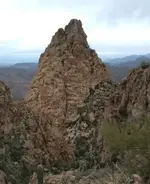
is this Indian woman clue: 'Look for 3 Teepees high up the mountain side'. These could also be the 'spires' mentioned by others.
View attachment 2064040
A Mexican clue advises: 'At the site, there are 3 monuments-a crescent, a rectangle, and a circle'. A monument is a stone on top of a stone. You will see this as you approach the Mexican foot trail onto the ledge coming from the North.
View attachment 2064041
This pic is looking into the bottom of the funnel shaped pit where the mine is, you enter from this side.
The waterfall/cliff are on the right. The red arrow points to an 'arrowhead' shaped rock that has been propped up.
The wall behind it is 'whitish' colored so this rock(clue) would be seen by the Mexican miners coming into the site from the North. 'There is a 'waist high, white square rock with an oblong corner'. The green arrow points to the
mine which is in a 'crack or crevice'(2 soldiers). There is about a 2 to 3 ft gap between the white granite and the 'rose quartz' vein. 'When you exit the mine you will see nothing but air'-its a cliff.
View attachment 2064046
This is an additional pic of the 3 white square/rectangle shaped rocks on the slope above the mine.
When you enter the bottom of the pit from the side, the East end of the crack/crevice is this volcanic vent hole.
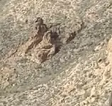
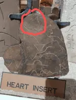
I believe this to be the 'Mexican Shrine' for this mine. The rock has been 'worked', there are 'etchings' of various designs and shapes, and the 'Hearts'. The heart is the Mexican treasure symbol and I can see this shape, in various
'ways', everywhere on this 'mural'. Some have the 'jagged crack' going down the middle of the heart and I see this in Spanish/Mexican mine symbol books. My apologies on not being able to zoom in on my pics and if there is an interest in this mural please let me know and I will zoom in and post.
*Note: The Mexican miners would carve a 'Cross' above the mine entrance, NOT directly over it, it would be on either side. I do not have a 'smoking gun' pic of this to post, but its here-Mexican mine requirement. I can see 'maybes' but not clear enough to convince me I have 'this' Cross..
The 2nd pic below is showing 2 arrows pointing to 'images', I have a zoomed in pic of these 2 images.
View attachment 2064101
View attachment 2064102
'
View attachment 2064103
View attachment 2064104
This is a ledge 10 to 15 ft under the mine and just East of the waterfall. This was the tailings dump and tailings were
thrown over the side. There are tailings on the 'East' side of the waterfall at the 'base' of the ledge(canyon floor). There are volcanic vent holes on the tailings ledge-the following 2 pics of vent holes are from the tailings ledge. These are directly below the mine.
View attachment 2064105
View attachment 2064106
View attachment 2064107
This is a pic of the crack/crevice from the waist high white square rock with the oblong corner, notice the pick ax work on the rose quartz vein.
View attachment 2064334
There are several 'volcanic vents' into the rose quartz vein in the bottom of the crack/crevice.
View attachment 2064335
I am out of space so this is the last pic, so best for the last.
'There is a square rock not quite blocking the entrance', 'you must be on your belly to enter the mine', and 'you can almost peak into the mine/cave where the dirt has settled'. I also see tailings dirt, a hole in the dirt where it is 'still' settling, and the mine entrance appears to be chipped to form the heart.
View attachment 2064338
This was a known mine before the Dutchman(The Sombrero Mine), and the accurate Mexican miner clues, documentation and maps, fit this location.
The Dutchman found this mine, and his 'story' advises he 'obtained' it from Mexicans miners who were working it. The detailed record keepers the Mexican miners were,
there is not another mine in here that would 'fit' for this time and location. For the Dutchman clues, the five mile circle 'From the Needle' or 'Needle is in the center', was my only 'questionable'
clue of his mines location. At 5 miles the Mexican miners stones/sketch maps fit, and I could see the horse head, 'exactly' as described. Once out here, all his other clues for this site are just as described. I would think you could not find another site anywhere out here, with this many 'detailed' clues, in their 'detailed' locations, and provided by 'different' peoples.
The proof I am advised I would need to provide would not be permitted by the Forest Service, they will verify if any Wilderness laws were broken to obtain it.
I do believe the Lost Dutchman mine can be 'verified' but the experts will need to figure that one out, I did the hard part.
Thank you for viewing my material and I hope this helps for anyone interested in this story.
Good Luck and Stay Safe!


 I don't think so.. Nor could u prove it. There is a quite a distance between them. One thing I can say, if NP was still around I would of opened him to a lil sum, sum. That he would of appreciated over in NM.