The Lost Doc Thorne Mine - was it the same mine of Jacob Waltz?

Last edited:
Just an added note regarding the Thorne Family. Dr. Abram D. Thorne had two brothers: Isaac Newton Thorne and Walter Scott Thorne. Both lived in San Francisco, California. Isaac died in 1903 and Walter died in 1913. Cordially, Gregory E. Davis
 

I will have to look through the forum or google it but there is a description of #Watz place described of where it would be today.
Something like 28th street and baseline,ect. Thats not exact,just an example.
 

Last edited:
I may be mistaken, but wasn't one of the two books Dr. Glover is getting published is supposed to address a lot of the other legends surrounding the Superstitions and gold mines/caches, etc... I wonder if the Thorne story is one of the things he dug deeper into?

Wasn't the first book supposed to be out already this fall?
 

Yes it was and I asked for an Autographed copy as soon as they where available but have never heard anything else.
I thought I asked Dr Glover when he posted about his new books.
 

1914 map. Jacob Waltz moved to the Salt River Valley in 1868 and filed a homestead claim on 160 acres of land on the north bank of the Salt River. It is from here Waltz began his exploratory trips into the mountains surrounding the Salt River Valley. If you click the pic below and then click the pic again it will more than fill your screen. You will see a black dot on the North side of the Salt River that could be the homestead.

We've all been guilty of taking threads off the subject (myself included), but let's really try to keep this on topic - The Doc Thorne mine/gold. Any discussion about Waltz's homestead belongs in a different thread.

The story about Thorne is an interesting one and worth it's own thread - just want to try to keep it from getting sidetracked please.
 

Greg - thanks for your posts, good to see you posting. As per your request, here is one example of an expedition by Dr Thorn reported:


Camp McDowell, A.T.
Capt. R.M. Crandal;
I see by your city paper that we are reported as living among the Apache Indians, in the White Mountains, and thinking that the public might construe that notice into something injurious to ourselves. I shall inform you how we came to be among these Indians, and if you think it necessary that the explanation be made public please hand this letter to the editor of the Arizonian:

Last May I started from Socorro, with a party to explore the White Mountains, and the Salt River. On our arrival at Cutero we failed to organize a party of sufficient strength to enter that country, so we turned out attention to the Zunis mountains where we found gold in paying quantities but no water. While in those mountains I learned that two parties of White Mountain Apaches had been into Fort Wingate to see the commanding officer, Col. A. W. Evens, 3rd cavalry, and that there would be a council held by the Apaches and Navajoes at the Ojos Calientas, south of Zunia about 12 miles. I took my party, went to Zunia, and started thence for Fort Wingate, leaving my party at Zunia. I remained at Wingate, with Col. Evens, several days, examined copies of the letters that these Apaches had brought in, consisting of letters from various prospecting parties who had penetrated their country and had been well treated by them. One of these letters was from Dr. Thorn of Limitar, N.M. who said that the Salt River, or Pinal Apaches had driven his party back, and on meeting these Indians of the White Mountains were treated very kindly; and were advised by them not to attempt to go farther west as they would be killed by the other Indians. All these letters spoke highly of this band of Indians, and on my consulting judge Turner, whom I met at Wingate, en route for Prescott, and Colonel Evens, also several other friends, I came to the conclusion to wait and have a talk with these Apaches. <much more follows of adventures with Indians>
I am, dear Bob, Yours truly
C.E. Cooley;
The Weekly Arizonian, Sept 4th 1869, col 2, not sure what page it is but looks like it is not page 1.

As this letter has but little info it does not add much, however it looks like Dr Thorn encountered Indians on the Salt river or Pinal mountains, which puts him in the same region as the LDM. I do not know if this C.E. Cooley is one and the same with Captain Cooley.

Thank you all for your posts, I look forward to reading more - please do continue.
Oroblanco
 

Greg & Roy,

[In southern Arizona depredations brought out small details. Large expeditions went on scouting and exploring missions. One of these, commanded by major John Green, met an unexpected situation. The Coyotero chief Miguel and his men, accompanied by C.E. Cooley and H. Wood Dodd, came to Green's camp. (Note 27)

Note 27: Corydon Eliphalet Cooley, born Apr. 2, 1836, in Ba., went to Santa Fe in 1856. He served as a Lieutenant in the 2nd. N. M. Inf. After the prospecting trip he remained in Ariz., married a daughter of Chief Pedro of the White Mt. Apaches, and settled on a ranch near Ft. Apache. He was a scout and guide for Crook. Cooley died Mar. 18, 1917.]
____________________________

The above quote is from page 171 Of "Chains of Command..." By Constance Wynn Altshuler.

Just thought I would add that to the mix here.

Good luck,

Joe
 

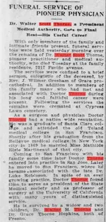
Found his brother's obituary (Walter Scott Thorne). Interestingly enough, Walter Scott was a doctor as well. No mention however of Abram Thorne at all all, however may be useful to try to trace down future relatives. Still looking, but it looks to me like it will take some onsite research in New Mexico to really pinpoint anything useful.

Walter Scott Thorne Obituary The San Francisco Call, April 25, 1913.JPG
 

Joe

First , I want to opologize to the readers because I want to return to Fish/Peralta map , but I don't like to leave something which I can to explain , unexplained .
In one link about Fish map which posted Wayne for me before two days , you wrote how the mine is in Black Top Mesa . You are wrong and all the others who have believed this . Look to the map . The Black Top would be little NW from the Weaver's Needle , and the " Mesa Negra " is little NE . The author was writing about Black Mountain , and the mine is between " El Sombrero " and " Mesa Negra " ( Black Mountain ) .
Is not very hard to read a map just to see the details .

Fish%20Map%201.jpg
 

Last edited:
G'd morning Cubber, coffee? '''ME''' go off of a subject?? never, never, well, ===== however, there has been an accidental slip due to my being a very poor typist??

Seriously my friend, Some times it is quite additive & objective to actually go off. for a bit or for a point.

Don Jose de La Mancha
 

Did not waltz and Thorne suppose to cross or be some where around the Verde river also.
I thought Thorne was to be around Verde and Tonto Creek.
Which is no where near Weavers.
Both places you could see Weavers and 4 Peaks. The fish map shows the X's just across from 4 Peaks. NNE of Weavers.
 

... Look to the map . The Black Top would be little NW from the Weaver's Needle , and the " Mesa Negra " is little NE . The author was writing about Black Mountain , and the mine is between " El Sombrero " and " Mesa Negra " ( Black Mountain ) .
Is not very hard to read a map just to see the details .

I was curious - does anyone have a comprehensive collection of maps from this region dating back to, say, the mid-1800's or even earlier? My experience in the Southwest is that place names (mountains, ranges, rivers, creeks) have tended to change or move frequently in this time span. Markmar raises an interesting point that has thwarted many a 'treasure hunter', IMO - different people have used different names for things at different times.
 

I was curious - does anyone have a comprehensive collection of maps from this region dating back to, say, the mid-1800's or even earlier? My experience in the Southwest is that place names (mountains, ranges, rivers, creeks) have tended to change or move frequently in this time span. Markmar raises an interesting point that has thwarted many a 'treasure hunter', IMO - different people have used different names for things at different times.

Greg Davis has arguably the best collection of Superstition Mountain maps - at least that I've seen - going back to military maps, etc in the 1800's... I'm sure he'll chime in with some thoughts, but here are the things I've noticed while looking through them:

1) I good portion of the old ones you're talking about are difficult at best to determine what peak is what - and many aren't named at all.

2) You're correct that the peaks and mesa's etc... have had their names changed a number of times - Tom Kollenborn is probably the person best qualified at this point to at least point out what names were used in the times of the ranchers and cowboys in the early 1900's. Don't know if he'll join in the discussion here or not.

3) Over the years, I've discovered that different people had/have different names for the different peaks in the Superstitions. All that has done is make it even more difficult to try to pinpoint exactly what's what out there.

To make a long story shorter, while it's actually a really good and valid question, answering it is extremely problematic. It's been tried many times before, and I think at one point or another, most people give up trying to pinpoint things back into the 1800's.

That said, maybe this is a good place to try again.
 

I was curious - does anyone have a comprehensive collection of maps from this region dating back to, say, the mid-1800's or even earlier? My experience in the Southwest is that place names (mountains, ranges, rivers, creeks) have tended to change or move frequently in this time span. Markmar raises an interesting point that has thwarted many a 'treasure hunter', IMO - different people have used different names for things at different times.


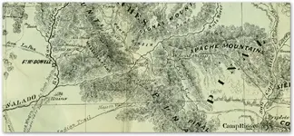
Below is a piece of a 1863/65 map with mines marked with an X.
 

Attachments

  • Arizona-Gold-Mines-1865.png
    Arizona-Gold-Mines-1865.png
    342.5 KB · Views: 251
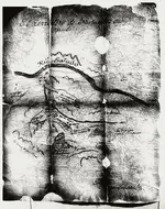
I have a couple topos from 1902. I also have a military map from 18something but it is a hand drawn map.
Some mountains or washes or creeks were not even on the maps at all and where just names used between prospectors,or hunters, cowboys,ect.
For instance,Picket Post. [Was originally named Tordillo Mountain, or the Grey Horse. ( by mexicans).]

Now read thisQUOTE-The troops started their mule trail at "Infantry Camp" at the foot of Picket Post and then extended it into Picket Post Creek (later called Queen Creek). The trail then crossed Devil's Canyon (named by the troops) and halted at a post they intended to build in what was then called "Mason's Valley" (later, Camp Pinal). The valley area is now known as "Top-of-the-World" or "Sutton's Summit."UNQUOTE

LINK for this

Just a quick rerad through here shows how many names came from the military,or private individuals and where later changed.
None of what oe some of what Waltz, or Thorne said was what they saw might not be what is there or what it is called today.
 

We can judge by what the people whom found the Pit mine did, they mined out a sizable amount of gold, and kept pretty quiet but eventually let it get into circulation that they had done it.

I would love to know the story behind this.I remember Cubfan and I talking about the pit mine back at the 08 or 09 rendezvous and how working during the summer months for 3 years would have been quite the undertaking.I just find this very fascinating.Happy Thanksgiving to all.
Steve
 

Last edited:
Somehiker, read my post 156 just above. It contains what you asked about. Plus a link to the whole story of the area around Superior,Picket Post,ect.
 

Somehiker, read my post 156 just above. It contains what you asked about. Plus a link to the whole story of the area around Superior,Picket Post,ect.

Read it, but maybe I missed the part where it said who "Mason" was.
 

Top Member Reactions

Users who are viewing this thread

Back
Top