Re: LDM why you can't get it !

(A work in progress) In an effort to better express my interpretation of this map which gives more evidence, I have come back yet another time.
Gentlemen, Ladies,
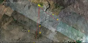
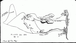
Map #10 (again),
I have come back to this Map because there is additional information to give credit to Red Mountain.
Additionally my point is Red Mountain, and little reference to the Superstitions only as viewed from a distance at a high point.
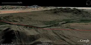
Not to repeat what has been discussed in previous posts, I refer back to post #110 Pg #6 for Map #10, and satellite image post #116
That being said:
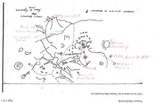
a) Center of Map is from 4 Peaks.
b) Small circles with line extending out, Peaks. Height/size of Peak in relationship to circle. Tail of circle direction in which to look,
c) Peaks drawn (as fist, index finger extended) have same shoulder (look @/towards).
Start point is small peak Stewart Mt (in line) between the two (radiating circles), one below 4 Peaks, other above MEQSA (MESA).
Radiating circles (view from this angle as an eye/eyes).
Tail pointing beneath (symbol) 4 to finger pointing (look from here "eye"), arrow curves (turn around) at 4 Peaks. The eye sees Red Mt as drawn from this view, which is in 180 deg. reverse on map.
Key is you can only see Weavers Needle from 4 Peaks, not from start point.
Wavy line from 4 Peaks (Salt River).
From 4 Peaks: Peak above Weavers Needle (between Malapais Mt & Tortilla Wells?) pointing towards correct direction, in close relationship to Needle. I believe this area would be a good spot to communicate by reflective mirror back to Red Mt or back depending on the days sun.
From 4 Peaks look beyond small peak: look to MEQSA (small peak in middle of MESA). adjoining Red Mountain. (Red Mountain is in 180 deg. reverse) character marks of Red Mountain reference post #110.
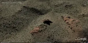
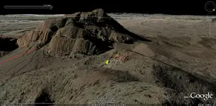
Dec 28, 2012 descriptive change below of the association of outcrop and Red Mountain, changes 2nd photo's accuracy and 3rd photos angle slightly. Thus, pin placement on 3rd photo should be well down the arroyo further left. This change will bring a more accurate image of the drawn Red Mountain. (New image at top of this post.)
From a small peak close at hand (large hand) pointing to outcrop @ Red Mountain. Outcrop drawn on map can be found 800 yds east, down the arroyo from largest outcrop that nearly touches the arroyo @ Red Mountain.
Ancient Salt channel is long red line with slight change and back on same direction.
Above 4 Peaks on map are two small peak symbols surrounding a symbol (MMM). Look this way between the 2 peaks to view the range/ridge line away from 4 Peaks
(IMO) There is Nothing on this Map that gives any precedence to the Superstitions, only Red Mountain, three or more times.......J


")