Dutchman's Caches

Last edited:
There is something lurking in the shadow:)
Look at 2017 image .....
I don’t know what is ... other than some sort of shallow cave maybe ?
 

Well .... that is bettever than getting your new emoticon ;)

It was the rocks to sit on, and I don’t know what it is. The location would not be what I would expect, but maybe in a ravine like that, you take what is available ... for refuge.

Glad you looked :)
Says something doesn’t it ?

From my optical view, always I believed would be a bad idea to set camp at the bottom of a ravine, not even under cliffs with rolling rocks.
 

Well .... that is bettever than getting your new emoticon ;)

It was the rocks to sit on, and I don’t know what it is. The location would not be what I would expect, but maybe in a ravine like that, you take what is available ... for refuge.

Glad you looked :)
Says something doesn’t it ?
i guess i just don't have the imagination some of you guys have...i never can see the stuff you see on g.e.....i started out using nasa worldwind somewhere around 2004...then a couple years later i found google earth..when i first started playing with the imaging software i thought it was the greatest thing since the fisher gold bug...until i actually went out in the field and saw how different it was than what i saw on nasa...g.e. is a great tool for finding the tears and rips and fault lines in the earth and old building foundations and such..but the resolution isn't good enough for a treasure hunter ...the government has the technology but they will never let us have it:dontknow:
 

Idahodutch

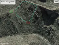
The spot you have pinpointed would afford all the water which would come from the blue region, water which could carry wood and rocks, etc.
The only good spot for a camp is on the saddle to the left ( green circle ).

Ravine   0216 image.webp
 

i guess i just don't have the imagination some of you guys have...i never can see the stuff you see on g.e.....i started out using nasa worldwind somewhere around 2004...then a couple years later i found google earth..when i first started playing with the imaging software i thought it was the greatest thing since the fisher gold bug...until i actually went out in the field and saw how different it was than what i saw on nasa...g.e. is a great tool for finding the tears and rips and fault lines in the earth and old building foundations and such..but the resolution isn't good enough for a treasure hunter ...the government has the technology but they will never let us have it:dontknow:

Glad someone else is in the same boat as me Dave - sometimes I think I'm the only one who can't see stuff pointed out here. I don't mind GE images, but I sure would like to see real feet on the ground photos of the same places side by side - for some reason I NEVER see that posted.

One time before heading to AZ I decided to test GE by spending some time scanning images of areas I planned to go. I spent WAYYYYY too much time scanning for interesting things to look for. Once I got out there that fall I spent a day visiting my "sites" and found absolutely nothing other than rocks, shadows, brush, etc... GE is a tool - no more no less - to use it SOLELY as evidence of finding something out there is a poor use of what that tool should be used for.
 

Last edited:
Since we don’t have something better to look at, at the moment, I am glad that we at least have more than a topo, for some representation. GE has improved much, but can be hard to know when or not, being tricked by image.

I can’t tell if that is a shallow cave or not, but it looks like that spot is not in direct path of drainage .... could be wrong, but actually looks to be just off to the side. Maybe was a place to work, don’t know, but better than most areas it looks.

If this is actually Waltz’s ravine, he said he had a camp in it ...... according to clues.

Lots of water and debris like boulders, rip up stuff while going down. Looking at that also, trying to get a feel. Should be a camp somewhere .... or where one was.
dutch..i do better with topos than google earth...i have a map program that i used to be able to use both g.e and topo side by side....that was excellent but google stopped supporting my map program so it no worky no more
 

dutch..i do better with topos than google earth...i have a map program that i used to be able to use both g.e and topo side by side....that was excellent but google stopped supporting my map program so it no worky no more

Dave,
That’s a shame they quit supporting it. I wasn’t try to imply that topo maps aren’t good.
Just saw something interesting, and wanted to explore it with you all.

I do believe that to make progress, it is important to continue with clues, and in this case, says Waltz camp is in ravine. Not on saddle.

I have a feeling that if I were able to post an excellent representation using a topo program, that it still would not give the detail that might be desired. :)
 

Inside of the ravine there is a spot that looks very suspicious to me, because it looks like it may be the site of a camp.
It is difficult to see.
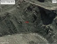
The first image is just of the ravine, but I added a Red Elipse surrounding the spot in question ... for location reference.

View attachment 1913492


The next three images are all of the same spot zoomed in, but are from 3 different years to help with vegetation and shadows comparisons.
Red Eleipses have been added to show the zoomed in spots.

View attachment 1913493

View attachment 1913494

View attachment 1913495

I had not noticed this little spot until recently, and found it interesting. The part inside of the shaded area, looks like could maybe be multiple rooms or areas?

I see nothing there that's different from its surroundings. Just more rocks and vegetation. Definitely not a place where I'd pitch camp. Keep searching, though. If you don't look, you won't find.
 

Skyhawk,
Thanks for the feedback. Boots to ground would be good.
Not a spot I’d pick either, just looks like may be something in the shaded part.

While you are here, I have looked more to see if I could see some kind of vent up on the upper part of saddle, where your equipment registered a deep hole.
Has any more come of that? Just curious
Idahodutch
 

Well....That’s all I have for the LDM.
I have been coming to terms, that it will not be me that gets to finalize the search of Waltz’s ravine.

You want to find the LDM? It is real and whatever is left of it, is somewhere in that ravine.
If I see more info that helps, I’ll post it.

Got to ask yourself. You looking for LDM, or not :icon_scratch:
 

Nothing new on the depression on the saddle. A trip there, up-close and personal, will be necessary to see the details. I'm presently giving consideration to hiking to that general area, carrying only ultralight backpacking gear, but I have to outfit myself first, so the trip won't be made this year. It looks like early Spring of 2022 will be favorable for that hike.
 

Ravine   0216 image.webp

The red circle is within the area Hank and Marion Harnish claimed as the Spanish Priest Hat claims. Harnish along with George Pierce and Bill Fowler claimed berween 25 and 30 mining clims there after forming the Christian Mining Company. Their claims covered a little over one square mile altogether. The Harnish brothers and Pierce dug several shafts and one adit into the mountain that went back in about 25 feet. The red circle is probably one of their camps or one of their diggings. I haven't been in that canyon since 1984 but remember seeing their Spanish Priest Hat claim markers. Bill Fowler was struck by lightning and killed out there while working on those claims. azdave probably knows more about Harnish's claims.
 

Matthew,
The blanketing of claims done by the Harnish brothers ... was it mainly here at north end of Black Top Mesa, and the lower part of Coffee flat canyon, on into LaBarge?

I have seen threads talking about their camp over by Coffee Flat, and that they were armed at that camp, and didn’t like anyone near their claims.

Was the same flavor going on here at this location as well?
With their camp being over by Coffee Flat, was that their main operation?

I didn’t know you had a claim over that way... above Harnish’s blanket.
Did you have concern ever, when headed to your claim?

It does look like a lot of probing ..... perhaps stabbing haystacks with pitchforks type of frenzy, before time ran out ....

I would enjoy reading and learning, if you are up for some sharing ..:icon_thumright:
Idahodutch
 

I said I would post something, if I thought might help.
The large boulder down in creek below the ravine, has “Finally 1966” spray painted onto it.
Diggings says Harnish filed claims 1980.
Big gap in time.

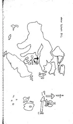
The Waltz Map, I believe dipicts the ravine, before Harnish started drilling and digging.
The waltz map, was drawn in leisure. ... not desperate to quickly convey .. or in time of frenzy, when leisure to draw map, was not practical.
So map maker was not Waltz, or Harnish.
Had to be the “Finally” claimant.

If there were 3 caches, 2 little ones, plus the big one above the mine;
And Waltz already got the 2 little ones. Then was only one cache left, when trying to get Julia there.
The Waltz map shows information for perhaps “renewed” cache sites, as well as looking to show mine site.

The Waltz map may be a VERY important part if wanting to find caches.
I would be careful to not disregard.

That chunk of time, before Harnish, but after Aylor was gone, is when I suspect the LDM was found, by mr. Finally.

I don’t think Harnish found what is shown on Waltz Map. I don’t think Harnish even looked for view of four peaks, why would he.

Waltz said no miner would find it ... But a Dutch hunter would follow clues and look perhaps, where a miner would not.

I also don’t think Mr. Finally cleaned it out either. I suspect he is who made the Waltz Map.
 

That little possible work spot/camp I pointed out, looks very very close to where a spot on the Waltz Map says Oro 17
I am not skilled for decoding.

A copy of the Waltz Map is on page 3
 

Matthew,
The blanketing of claims done by the Harnish brothers ... was it mainly here at north end of Black Top Mesa, and the lower part of Coffee flat canyon, on into LaBarge?

I have seen threads talking about their camp over by Coffee Flat, and that they were armed at that camp, and didn’t like anyone near their claims.

Was the same flavor going on here at this location as well?
With their camp being over by Coffee Flat, was that their main operation?

I didn’t know you had a claim over that way... above Harnish’s blanket.
Did you have concern ever, when headed to your claim?

It does look like a lot of probing ..... perhaps stabbing haystacks with pitchforks type of frenzy, before time ran out ....

I would enjoy reading and learning, if you are up for some sharing ..:icon_thumright:
Idahodutch
dutch...the harnish boys were in the supers way before 1980....the site called the diggings only shows what comes up online at the county recorder...pinal county recorders office only goes back to 1980 online...if you want to search documents filed before 1980 you have to go down to the office in person
 

Where on the map does it say "oro 17" ?

Waltz Map.webp

For me, I don't consider the map genuine.
More likely made by someone who merely thought they knew where it was, IMO. I seriously doubt JW would have used the word "oro", or even said it while giving directions to the person who did.
 

dutch...the harnish boys were in the supers way before 1980....the site called the diggings only shows what comes up online at the county recorder...pinal county recorders office only goes back to 1980 online...if you want to search documents filed before 1980 you have to go down to the office in person

azdave,

You are so right Dave. Idahodutch should understand that the Harnish brothers were in the Superstitions back in 1960. Those days, the 60's through the 80's were a different time and a different place the newer dutch hunters could hardly understand or even imagine. Permanent camps everywhere, fights and disputes over numerous claims, everybody armed to the teeth.

Hank Harnish had claims as far back as 1963, not all in the same place and his MO was to blanket an area to keep others away. That causes a problem because many claims mean many yearly assessments. Harnish used investors much like Crazy Jake did. He got hauled into court in Phoenix for scamming people but got off when no one would testify against him. He even had the old Apache Junction radio station, KSTM 107.1 FM run adds for his investment opportunities.

The Harnish brothers were all over the mountains between 1960 and 1990, their main area was LaBarge and Picacho canyon but they spent many years in other areas and hired many down and outers to work and guard those claims.

I ran afoul of Hank and his brother on several occasions, never came to actual gun fire but only by a hair or two.

Idaho dutch should not assume things but should learn the history of the people and times for the areas he is interested in.
 

Top Member Reactions

Users who are viewing this thread

Back
Top Bottom