DOC NOSS-Victorio Peak OR The Caballo Mountains

Of course those are not my maps, and I look forward to opinions on their authenticity. If there were samples of Doc's handwriting floating around, they could be compared to the handwriting on these maps.
 

The one main problem that I see you all have, is you say the noss family, like they are so close to keep secrets from the world. there never has been what you would consider a family , these people really
didn't like each other, they all had there own sense of greed, they really shared nothing,not even doc's blood. doc only had one blood line, and it was never shared with anyone in this so called family except for lethra , who kept it a secret for a long time. :coffee2: time. np:cat:
p.s. broken promises are never forgotten.
 

Can someone post or PM me with the GPS for the mouth of the large bat cave that is visible from I-25? Mucho appreciado.
 

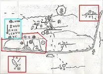
Because the experts still to be silent , I will tell you some details of this map :

- This map has four (4) different maps attached on it .
- The rising sun is always the half sun .
- The setting sun has the Egyptian cross infront , which mean how is a east to west view .
- The symbols which were added with the other known in the treasure maps , are described at the left up corner .

These are some of the details on this map . This map and the green maps , describe the same region . The key to find this region is the lil map .
I hope these details wiil help a bit .

First,

-For you to know this map has four maps in it is AMAZING! Why aren't you there digging it all up?

-The rising sun is NOT always the half sun. A half sun with RAYS EMANATING is a SUNRISE (or EAST). A half sun with NO RAYS EMANATING is a SUNSET (or WEST). So, what this half sun is telling us is (there are EIGHT rays on it, one is not very evident though) something is eight days travel East.

-In Colonial Spanish times, it was common practice to orient maps so that East was at the top of the map (this is also denoted in the orientation of the rising sun bottom center)

-If you are so certain of your hypothesis, please explain each? To me, that's a jump.

Just to tell you, I have a lot of experience with Colonial Spanish Era maps and documents. I also know what a lot of the different coding means.


Mike
 

Decoder Ring ? Heard like a magical ring . This reminds me a movie with someone who has a ring like this and repeatedly telling " Precious , my precious " .

Nah, that stuff is nasty, but thanks for your concern! I don't recall mentioning what I believed, only what I read. That Decoder Ring enable you to read minds too?
 

Last edited:
Mike, I welcome your input on any specific elements of the map you have an understanding of. I appreciate you verifying the top of the map is east as well. Still pondering the ankh, as well as the hashtag, capped hashtag, half circle with arrow, arrows, and roman numerals.
 

First,

-For you to know this map has four maps in it is AMAZING! Why aren't you there digging it all up?

-The rising sun is NOT always the half sun. A half sun with RAYS EMANATING is a SUNRISE (or EAST). A half sun with NO RAYS EMANATING is a SUNSET (or WEST). So, what this half sun is telling us is (there are EIGHT rays on it, one is not very evident though) something is eight days travel East.

-In Colonial Spanish times, it was common practice to orient maps so that East was at the top of the map (this is also denoted in the orientation of the rising sun bottom center)

-If you are so certain of your hypothesis, please explain each? To me, that's a jump.

Just to tell you, I have a lot of experience with Colonial Spanish Era maps and documents. I also know what a lot of the different coding means.


Mike

Wow ! My apologies for my effrontery to try to describe a map which is easy for the experts ( who never found the treasure ) to decrypt it .
 

Last edited:
Mike, I welcome your input on any specific elements of the map you have an understanding of. I appreciate you verifying the top of the map is east as well. Still pondering the ankh, as well as the hashtag, capped hashtag, half circle with arrow, arrows, and roman numerals.

You didn't understood . Gollum don't said how the top is the east , but how a half sun is not always the east .

And for the records and the curiosity , I post the map with the other three maps inside ( red marks ) and the description of the symbols ( siel mark ) .

SpringfieldWillieMap.jpg
 

Last edited:
Wow ! My apologies for my effrontery to try to describe a map which is easy for the experts ( who never found the treasure ) to decrypt it .


Hmm - what leads you to think that this treasure was not found and removed? Thank you in advance;
Oroblanco

PS Gollum has some excellent info on his site, I highly recommend it:
Victorio Peak Treasure
There is good reason to believe the treasure is not only found but was removed decades ago.

:coffee2: :coffee: :coffee2:
 

Hmm - what leads you to think that this treasure was not found and removed? Thank you in advance;
Oroblanco

PS Gollum has some excellent info on his site, I highly recommend it:
Victorio Peak Treasure
There is good reason to believe the treasure is not only found but was removed decades ago.

:coffee2: :coffee: :coffee2:

I agree , is a possibility which could be accepted .
 

Markmar,

I never said that I knew all the meanings of every symbol. Your words seem to indicate that you do.

Based on the rising sun symbol, this is the correct map orientation:

SpringfieldWillieMap.jpg

Mike
 

Markmar,

I never said that I knew all the meanings of every symbol. Your words seem to indicate that you do.

Based on the rising sun symbol, this is the correct map orientation: ---

Mike
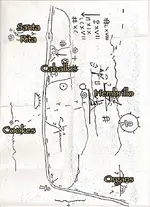
Yeah, if that's supposed to be the Rio Grande in the middle of this thing, then the map's orientation is a no-brainer due to the river's alignment and Matt's apparent discovery of an earlier permanent midstream island. Granted, we know the Rio Grande's course has meandered all over the place over time, but the main flowline orientation hasn't. Anyway, that being the case, the sun symbols would be redundant information, and possibly mean something other than sunrise/sunset.

However, as always with any Noss stuff, the opening question in the dialog is about the map's provenance. Any information on that? Were the map's papers, inks, etc. on any of his stuff age-verified?

WillieMap2.jpg
 

Last edited:
Actually, I was looking at current GE maps when I saw a couple of islands. I need to do as you suggest and look at older, pre reservoir maps as well.

Doc supposedly got a map from an old Indian in lieu of payment he was treating as a podiatrist. No idea if that was this map or not.
 

Last edited:
Actually, I was looking at current GE maps when I saw a couple of islands. I need to do as you suggest and look at older, pre reservoir maps as well.

Doc supposedly got a map from an old Indian in lieu of payment he was treating as a podiatrist. No idea if that was this map or not.

Presumably the islands were located under the current lake, maybe the Elephant Butte formation itself. Any aerial photos may be irrelevant due to the controlled flows in the river in modern times. For example, last time I crossed the Rio Grande (a month ago), it was bone dry. During various conditions when there is water in the river, the sand bars look like a continuous string of islands. The map seems to indicate something significant and permanent for the times.
 

Actually, I was looking at current GE maps when I saw a couple of islands. I need to do as you suggest and look at older, pre reservoir maps as well.

Doc supposedly got a map from an old Indian in lieu of payment he was treating as a podiatrist. No idea if that was this map or not.

Doc supposedly got a map from another old Indian in prison too, and of course he got big secrets from Geronimo when he was eight years old. Do we even know for sure this guy was part Native American? I know what the book says, but has anyone checked the tribal rolls, or a birth certificate, etc. I wonder if the Cheyenne thing isn't yet another "fact" that only Doc knew for sure.
 

Top Member Reactions

Users who are viewing this thread

Latest Discussions

Back
Top