DOC NOSS-Victorio Peak OR The Caballo Mountains

Ah,here we go! Check out this link HERE

"Some theories hold that the ankh symbolized the sun rise..."

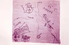
So if that's true, then the sun above the horizon would represent the sunrise, not the sunset. Which also matches the orientation of the Rio Grande on the map. North should be to the left of the map as far as I can see, with east at the top.
 

Hmm , you are correct it is looking towards the west NP's lil map shows the general data. The trail goes East to the Victorio Peak to treasr,e then continues East to the Eastern side of the Caballo, curves to the soutj. and ends up on the Eastern side od the Caballo.

3.JPG
 

In Book I of the Gold House, they claim the Bloody Hands site, Hembrillo Basin, VP, the Caballos, etc, are all shown on this map. So if that is true, what is what then? We should circle and label each part of the map if that is an accurate claim.

The Roman numerals in the "tally area" (just my description) are from top to bottom 68, 17, 1019, 50117, and 90. The symbols next to the roman numerals ( hashtag, capped hashtag, and half circle with arrow) may indicate what is being noted by the roman numerals (just a guess)

What does the capped hashtag represent?
What does the plain hashtag represent?
what does the half circle with the arrow mean?

Also, we see several spirals on the map, some circling cw, and the others ccw. A T-net member posted a story about a Spanish rock map south of Cortez, CO that he claimed to have deciphered, and he felt the spirals told you where to begin and end the trail shown on the map...

When an acquaintance in Las Cruces (not Roger Snow) first sent me a copy of this map scan ten or fifteen years ago, I assumed that it showed the Rio Grande with the Caballos above it, Victorio Peak and other sites above the Caballos, the Organs off to the right, and below the river, the Cookes Range on the right and the Santa Rita area on the left. You're right, though, it's daunting to try to look at the map as a whole without knowing what the symbology means. So let's just dive into it, piece by piece for the fun of it.

It's hard to say what any of the map symbols actually mean, since we don't know who produced it or what the symbols meant to him. He may have created and assigned his own meanings to all of them (hashtag variants, etc). Or, maybe they represent carvings to look for.

It's easy to assume that we're looking east with the Rio Grande being the double line running through with a near 90 degree bend on the right side, but maybe not. As markmar indicated, the ankh can arguably indicate "west" too, since it is associated with "eternal life", or "life after death" and has been linked to sunset, since that is where the sun goes when it "dies". As far as this map is concerned, do we have any reason to choose west for the ankh? Well, we do know there is a panel of unusual petroglyphs west of the Rio Grande toward the Gila headwaters/Santa Rita area that includes a number of Egyptian-like symbols including two obvious ankhs, one of which is shown below. In addition, these ankh carvings are precisely linked to a certain trail of spiral carvings nearby, one example of those also shown below. Collectively, the ankh, spirals and other symbols common to our Noss map lead to a location significant to some New Mexico treasure hunters. Perhaps all of this is coincidental to the Noss map, but this location's additional link to the Noss map will be further noted below.
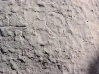
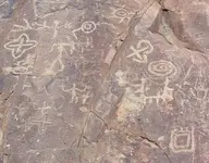
ankh.jpg spiral.jpg

It's unusual that two separate sun symbols are used on the map, the second one being the familiar half circle with rays, which usually means sunrise, or "east". Both sun symbols have seven embellishments. And as far as the ankh is concerned, it may mean something different than the sun - after all, there is a second ankh sitting at that 90 degree bend in the "river". Can both be used as suns? This is a bit confusing.

The "LCXVII" is not a proper Roman numeral. That being the case, maybe it, and the others, mean something else. It has been mentioned in the lore that a sextant was used with the Willie map to help find the cave. The sextant could be used to find latitude, but without an accurate timepiece and an ephemeris, that's all. By the way, do we know that the map we're discussing here is the "Willie map", or is it a second, separate map, a "Doc map?" Assuming it's the Willie map too, perhaps the "Roman numeral" symbols can be converted to coordinates or distances along a latitude line - one found using the sextant. By "coincidence", Victorio Peak, the Willie/Drolte/Hackberry canyon and the Santa Rita area site referred to above all sit on the approximate 32 degree 55 minute latitude line.

There's lots more. I wish we has a better resolution picture to work with - a lot of the finer detail in the map is hard to make out. The Gold House writer did us a disservice with the lame graphics and photos used in the book.
 

The map I posted is in Book I of the Gold House, and is represented as the map Noss used to form his thinking that there were seven caches to find.
 

Why river bend ? Maybe you didn't read what I have wrote . Don't reject my description before will have one better .

lol, consider the possibility that not everything I post is a response to you...
 

Hmm , you are correct it is looking towards the west NP's lil map shows the general data. The trail goes East to the Victorio Peak to treasr,e then continues East to the Eastern side of the Caballo, curves to the soutj. and ends up on the Eastern side od the Caballo.

View attachment 1080236

You are right , if remove the red letters . The VP is east of Caballos .
 

Last edited:
So then, if the map is indeed looking west, then what river are we looking at? Where does a 90 degree bend occur to the east along the Rio Grande that will match the rest of the map?
 

In Lure of the Caballos, the author mentions crossing the Rio Grande near the bend around Rincon, and finding ruins there in abundance. Perhaps the ankh on the river bend was telling us something about that location. It even has an arrow pointing to it across the river. But that only works if the map is looking east, not west...
 

The map I posted is in Book I of the Gold House, and is represented as the map Noss used to form his thinking that there were seven caches to find.

Right. But has anybody confirmed that it is the same map that Jack Reynolds or Willie Douhthit or whoever else "found it" in the late 20s used to find the Caballo cave?
 

Of course I have no answer to that sdcfia, I am just trying to figure out if this map is worth anything. Noss supposedly thought it did, but perhaps he was using other maps the family is still holding secret, and this map was published for effect.
 

In Lure of the Caballos, the author mentions crossing the Rio Grande near the bend around Rincon, and finding ruins there in abundance. Perhaps the ankh on the river bend was telling us something about that location. It even has an arrow pointing to it across the river. But that only works if the map is looking east, not west...

I agree. If that double-lined track is the Rio Grande, and not, say, a trail, then the only feasible 90 degree change in direction is in the Hatch-to-Rincon stretch. That seems obvious. It would be interesting to see a good map of the river before they created Elephant Butte Dam/Reservoir. If you could identify a prominent "island" in the river there, like what's shown on the treasure map, that would probably nail it down for certain. But why would an ankh be needed at the big bend?
 

I agree. If that double-lined track is the Rio Grande, and not, say, a trail, then the only feasible 90 degree change in direction is in the Hatch-to-Rincon stretch. That seems obvious. It would be interesting to see a good map of the river before they created Elephant Butte Dam/Reservoir. If you could identify a prominent "island" in the river there, like what's shown on the treasure map, that would probably nail it down for certain. But why would an ankh be needed at the big bend?

Get out of my head! I already looked for islands in that area of the Rio Grande and found two...
 

Of course I have no answer to that sdcfia, I am just trying to figure out if this map is worth anything. Noss supposedly thought it did, but perhaps he was using other maps the family is still holding secret, and this map was published for effect.

Since you mentioned it, I have to share your suspicions. If this map came from the Noss camp, it must, by definition, be looked at very warily. Here's why. Put yourself in the family's position, or anyone else's who thought they had a real treasure map for that matter. If Doc Noss had genuine treasure maps in his possession (and IMO that's a huge "if" to begin with), and you obtained it, would you publish the real thing for the world to see? Or would you put together something "acceptable" for release? After all, if there are seven sites to find, several of them are still undiscovered, aren't they? On the other hand, the maps may have been fakes from the beginning.

Well, we're kicking around the map from the Gold House book today - and also np's "Noss map" - because that's all we have to kick around. Who can show that either or both of them aren't complete frauds released with a purpose - to waste our time with typical treasure book maps and other stuff? Why didn't the Nosses, if they wanted to "prove Doc's story", do the routine document forensics necessary to establish the maps' authenticities? Maybe because Doc cooked up both charts himself to back up his stories. If the family indeed does possess some genuine articles, I assume they have tried to use them. According to np, after Doc's death, they had a big interest in the Caballos. I'm still a believer in the Caballos.
 

Right. But has anybody confirmed that it is the same map that Jack Reynolds or Willie Douhthit or whoever else "found it" in the late 20s used to find the Caballo cave?

In my opinion , this map and the green maps without the lil map are worthless and don't lead anywhere . I believe Willie found the cave following only the lil map . The other maps , I believe , were above of Willie's knowledge in map decrypting . And I believe so , how Willie had not found any of the seven scaled doors , but the exposed lure cave which was near . This cave is recognized in the green map , with a black entrance . If we look at the book's map ( the last posted ) , in the right up corner is written 7+1 . The 1 is the lure .
Why I believe Willie had not found any scaled door ? Because a scaled door is a trap . Are two doors with different directions . Have to walk on the first to open the second . This type of trap , I believe , would been mentioned from Willie or Noss if they could pass to the second door .
 

I completely agree sdcfia! Like Sgt. Schulz, we know nothing, we only have things to guess about.

I have also seen maps posted by people claiming they were maps of Doc's, but without a shred of evidence to back that up. I want to post them here, but they are in pdf form.View attachment DocMaps.pdf Not sure if they are displaying correctly, they sure aren't from my end. Now perhaps people understand my earlier request for example for Doc Noss's hand writing...
 

Last edited:
Nah, it kind of tastes like Thunderbird, but thanks for your research. Isn't the Internet wonderful? :icon_thumright:


Really? Does it require eating Cap'n Crunch and using a special Decoder Ring?

If you believe T was for Tayopa, then maybe you should have some.
 

are you seeing map images, or just a pdf attachment? Or none of the above?
 

Top Member Reactions

Users who are viewing this thread

Back
Top