DOC NOSS-Victorio Peak OR The Caballo Mountains

Can't quit lying eh Rog?

You are saying that Claude Suddreth never knew the location of the cave? Then why are his initials carved in the interior? Maybe you can explain that little fact? There are about seven sets of initials carved into the cave wall. Your dad's is not one of them. I know the names of every person that entered the cave and left their initials. Claude was one. So was Oren AND his son. Your story reeks of BS Rog!

Mike

calling a member a liar eh ?

never banned eh ?

The Cave never existed , but skull goons like you and Oren believe everything said about treasure

Claude took Oren to a cave
not a cave with 1300 steps , just as his Son Told you here in this forum .

so , if the cave is fiction told by my dad ,

tell us whose really full of BS ,,,

and like Treasure Hunter stated : Post by the rules , which calling me a liar is against .

but you've always bullied people who couldn't slap you .

you sure ran like a weasel when someone your size came at you ,,,

Gawd that Video of you running like a Terrified Child was funny

shall I post it before I'm banned again ?

you didn't expect a Visit from the Team did you ,, now you have no problem keeping your fat mouth closed
do you baby boy ?

see ya again sometime ,,, real soon I'd wager
 

as I said , I can't post without you popping off your mouth right in the next post


Then stop giving ammunition Rog
 

and for you :
G.A.P.metal
user-online.png


This Forum of your's has been reported as an attack site full of viruses bud .

don't like it ?
go cry in your soda dork bone

dork bone ? no one calls me that !
Gary


got'cha all crying now

real simple ,

when a bunch of you clownboys came into my forum trolling
we collected your IP's

like it's said , That forum is populated with high tech IT's .

we're all good at what we do
we've been a group of friends for decades

Tayopa
you in mex huh

are you using Telephonica as your provider ?

stop crying like kids
Man up

your game is old

as I said , This forum has been used as a hackers haven too long

it's on the books now

the increase in exposure of that is already in process .

see ya's
and stay out of Rucker Canyon kiddies

those snakes in there bite and ask questions never .
last stupid agents that went in there , darn near died from the bites

you've been warned , they will get cha
 

I understand your point, except that the Apache - who are often credited for the pictograph panel in Hembrillo Basin - did not create petroglyphs.

Checked with native buddy and he says 2 of the 9 bands he knows a lot about did make both picto and petro. These being the Chihenne and Mimbrenos. Most other picto only. "Red paint People". So, you are mostly right as far as I can tell. Not sure what all the books say. In any event, Bloody Hands was a picto so any band could have made. But, I must be missing something here. What I was trying to say is that Gollum or someone else was looking at what I see as the hands pictos as if they were some kind of twin volcanic necks or buttes or mesas or something (on the Noss book jacket map).

Also, drove past Black Mesa on the way south today. Sure looks like the square mesa/thing with the cross on the 'Lil Map...
 

Hi TM2, I think Gollum was banned a while back at some point (old threads) and had his time out, so he's not immune.

I hope we can all calm down and get back to fun posting.

I know it's hard. I got worked up by the cloud-shape-interpreters-we-know-100%-theres-stuff-here-cuzz...we-say-so-and-circled-it-in-the-JPEG guys and gave myself a timeout recently.

Drove by Cookes today (pavement only... boo hoo). Know that area less well. Would love to hear more about it. Maybe a new thread for that topic?

You're not conning us are you ?

Odd , I haven't seen you Ban your Troll buddy " Gollum " for breaking rules all over this forum .

get real dude , many members here are stating that your biased in who you will ban .

it's clear to every reader that you placed a target on my back .

Obey the rules as you command others to do .

you're looking lopsided bud , a Lopsided Joke to be concise .
 

Checked with native buddy and he says 2 of the 9 bands he knows a lot about did make both picto and petro. These being the Chihenne and Mimbrenos. Most other picto only. "Red paint People". So, you are mostly right as far as I can tell. Not sure what all the books say. In any event, Bloody Hands was a picto so any band could have made. But, I must be missing something here. What I was trying to say is that Gollum or someone else was looking at what I see as the hands pictos as if they were some kind of twin volcanic necks or buttes or mesas or something (on the Noss book jacket map).

Also, drove past Black Mesa on the way south today. Sure looks like the square mesa/thing with the cross on the 'Lil Map...

Yes.
 

Oh yeah, and Rog, I make this plea since you seem to be one of the very few with deep knowledge of the local mountains, versus others with lots of less direct knowledge and generic opinions, so I really hope you want to/can keep posting. I'd love to get to prove somebody right one day...

Hi TM2, I think Gollum was banned a while back at some point (old threads) and had his time out, so he's not immune.

I hope we can all calm down and get back to fun posting.

I know it's hard. I got worked up by the cloud-shape-interpreters-we-know-100%-theres-stuff-here-cuzz...we-say-so-and-circled-it-in-the-JPEG guys and gave myself a timeout recently.

Drove by Cookes today (pavement only... boo hoo). Know that area less well. Would love to hear more about it. Maybe a new thread for that topic?
 

(Referring to twin buttes/mesas unless I am confused...)

Well then, there must be data or info that I have no knowledge of at all 'cuz I went straight to "bloody hands" when I saw those marks.

Still more reasoned out than cloud chasing...
 

(Referring to twin buttes/mesas unless I am confused...)

Well then, there must be data or info that I have no knowledge of at all 'cuz I went straight to "bloody hands" when I saw those marks.

Still more reasoned out than cloud chasing...

bloody hands not.JPG
 

(Referring to twin buttes/mesas unless I am confused...)

Well then, there must be data or info that I have no knowledge of at all 'cuz I went straight to "bloody hands" when I saw those marks.

Still more reasoned out than cloud chasing...

nmth:
I also interpreted the twin marks as "bloody hands".
I an earlier post, Gollum had suggested that they were the "two volcanoes" at the Malpais. Which are in that approx location relative to victorio peak etc.
wr
 

nmth:
I also interpreted the twin marks as "bloody hands".
I an earlier post, Gollum had suggested that they were the "two volcanoes" at the Malpais. Which are in that approx location relative to victorio peak etc.
wr

Thanks WR.

I definitely do not see the geographic relevancy myself.

The N-S scale on the map is almost spot-on from what I can figure, so those "stumps" would be 1 mile or something from Vic Peak if that's what they are. Why not Bloody Hands petro location just a bit to the north of both Vic and Geronio peaks?

My N-S scaling is based on geographic features in the Caballos, surrounding Hills and the river, and my knowledge of local petroglyph locations and mineral deposits and other features that correspond with a lot of the symbols (again, per my interpretation). I printed the map out on graph paper and tied it to major features, especially the bend at Rincon and the river and the main "breaks" in the Caballos. E-W scale is not as accurate.

Also, BTW, the Caballos ARE on at least one older (pre-anglo) map. 1770 Bernardo Miera y Pacheco. It's a slightly different map than the 1776 or whatever more common one that pops up on the web. I'll dig up a reference and post it in response to SDCFIA's earlier post somewhere which seemed to claim that the name was an anglo invention. The same map has the Point of Rocks labeled as "Perillo" which is very relevant per my research, so it's not a replacement name - lots of things I have discovered vis a vis name drift and precedence are solidified by finding both or all alternate/confused names on a single map. BTW, the Organs are also labeled on this map, and in the correct location.

Anything you can share from your trip to the Organs?


Thanks for your earlier post of the old mines and cross, etc. up on the hill. I'll be back again sometime and shift a bit from metalliferrous rock beepy time recovery to petro/old workings searching now that you have provided some inspiration of that flavor for the locale.

This is a nifty area and region for sure, but I'm not sure what it could have to do with the book jacket Noss map unless the map is a Rorshach test.

We don't have to tie all leads to a single location, do we?

I'd like to see the provenance on all things Noss. The guy was a career con man who was killed for his lying and treachery over some alleged gold bars. Hello. Why should anyone innocently swallow the claim that his maps are genuine? When the ages of his maps are forensically determined, then we can decide if a serious discussion is warranted. And for those who claim his maps were copies of much older maps - just where, when and by whom did the originals come into being? And where are they now? I'm not asking you to provide those answers, nm - I don't believe anyone knows. Why? Maybe because the whole shebang was just Noss whiskey talk?

A single location? Good question. First we have to get a handle on where all those "leads" came from and when they originated.

I'm interested in seeing that Miera y Pacheco map. His 1758 map, the original of which was "lost" in the 1930s (hmmm, there's that pesky decade again), shows the current Caballo Mountains' location, but they are not named. The Jornada del Muerto is. By the way, Thomas Jefferson and Alexander von Humboldt made use of Miera y Pacheco's maps of the New Mexico region. Those two guys are also tied to some treasure legends in the area - von Humboldt having visited a couple years before Pike, and Jefferson vis-a-vis the Louisiana Purchase, but also in regard to his "axis mundi work".
 

Thanks for your earlier post of the old mines and cross, etc. up on the hill. I'll be back again sometime and shift a bit from metalliferrous rock beepy time recovery to petro/old workings searching now that you have provided some inspiration of that flavor for the locale.

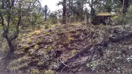
Speaking of old workings, I stumbled upon this one this morning in quite a remote location in the Pinos Altos area. The dumps in this country don't usually support much vegetation, but this one does and provides good camouflage. The adit is above and to the right, and has been covered over. If I was a younger man, I'd have that thing open and explored tomorrow, for curiosity's sake if nothing else. Nowadays, my ambition for picking and shoveling is waning, so this goes onto the "maybe later" list.

IMG_20161116_110655508_HDR.jpg
 

Top Member Reactions

Users who are viewing this thread

Back
Top