DOC NOSS-Victorio Peak OR The Caballo Mountains

OK,I.ll acept your word whisky, I don't have google earth on my computer. The reason that I mentioned it, was upon blowing up Rog's photo, the other road and data were blurred, while the new road was sharply defined. I apologize if I have been wrong, and I have been from time to time :tongue3:
 

Last edited:
Hi Rogmy friend,you posted
Not interested ?
May I ask , why then would you even ask me questions ?
as a fact , you certainly reply to my post with enough of them .


Of course all were Jesuit or Tayopa related, nothing to do with the Templars.:laughing7:
 

Last edited:
So what symbols, etc. could I find for you in the Caballos that would bolster your story? Especially, what is most uniquely Jesuit?

I have access to a good deal of pictures of glyphs, etc. from in and around Caballos, so give me a shopping list. If there are things that are more Jesuit than not, then we will look for them wherever I stomp the dirt.

The crossed circle with a hatch is found here and there. Is that one? There's an example in the Lilo post over in Symbols and Signs part of the forum. There's one over in Cookes and another at the S. end of the Caballos. Pretty consistent form, not like all the Mogollon geometric stairstep and swirly dos that are like cloud-gazing that are found all over.

Stuff like circle-dot is problematic since its such an easy form and some of the ubiquitous square eye pairs (corn-stalk Tlaloc or something?) look sort of round sometimes, and those are all over; "wherever you go, the eyes will be upon you..." so is that Chato waybill or apocryphal admonition referring to the glyphs or the stone arches in the Caballo region? There's a general problem with the word Ojo. But the Jesuit crowd and others say the Chato waybills are all malarkey anyways, so maybe the eyes can be ignored.

Unless you're a William White chela (god help you), the Jesuit angle is a complete dead end for folks interested in the Caballo region. Yes, Don Jose valiantly uses an alleged "Noss map" to support an unsupportable theory that the Jesuits cached gold in the range, but constant repetition of pure speculation is not a convincing argument.

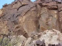
Eyes on you? How do you like Cuco?

Cuco rock 2.JPG
 

I am just sort of randomly going through old posts here, so maybe this has been brought up already: why not bloody hands?

I understand your point, except that the Apache - who are often credited for the pictograph panel in Hembrillo Basin - did not create petroglyphs.
 

I understand your point, except that the Apache andother who are often credited for the pictograph panel in Hembrillo Basin - did not create petroglyphs.

Hmmmm. You seem to have an excellent track record, as good as anyone serious here.

Though, I have counter info from other trusted sources, too.

Examples without documented support (remember, I'm mostly just a dirt pounding prospector, though my brain is not made of straw) include the Florida eye Crack pictos and the Chloride pictos.

oh crud, I missed picto petro. We'll then, what about Massacre peak stash guide glyphs and other (assumed) generally culturally consistent things like fringed dancers, society symbols, etc plus all the post contact stuff like guys on horseback and the Rincon sodbuster and so on?

Rock art has a general attribution and age dating problem.

Got to look this up now.

I like Cuco pic! Thanks.
 

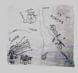
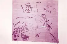
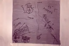
Sdc, you posted --- Yes, Don Jose valiantly uses an alleged "Noss map" to support an unsupportable theory that the Jesuits cached gold in the range


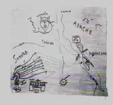
And just how else would you explain the massive amount of dore' bars ?? The lil map does it perfectly.
incidentally I originally was for a series of missions to the Matamoros region as their route, then NP's LIL map showed up and explained precisely how and why I was mistaken.

There is data on that lil map that could not have been known until I discovered Tayopa -- the key. With the location of Tayopa Known, the rest falls in place nicely.

Incidentally, I did not discover that idea, another member of the forum did and practically had to drag my nose into it, I was so fixed on the Mission route, despite it's many negative points. The Lil map clearly represents the most logical route, it cuts travel by mule 2 / 3 in both time, expenses and most Importantly, a logical place to store the dore' bars until a Jesuit ship showed at one of the bays near Matamoros.

No, that ll map, regardless where it surfaced, or by whom, is a very important piece of data, and it dovetails perfectly. Whether Noss, willie, or whomever and wherever it was found, the original was perfectly true.

I will always be grateful to NP for posting it , and giving me permission to use it
 

Last edited:
Sdc, you posted --- Yes, Don Jose valiantly uses an alleged "Noss map" to support an unsupportable theory that the Jesuits cached gold in the range


And just how else would you explain the massive amount of dore' bars ?? The lil map does it perfectly.
incidentally I originally was for a series of missions to the Matamoros region as their route, then NP's LIL map showed up and explained precisely how and why I was mistaken.

There is data on that lil map that could not have been known until I discovered Tayopa -- the key. With the location of Tayopa Known, the rest falls in place nicely.

Incidentally, I did not discover that idea, another member of the forum did and practically had to drag my nose into it, I was so fixed on the Mission route, despite it's many negative points. The Lil map clearly represents the most logical route, it cuts travel by mule 2 / 3 in both time, expenses and most Importantly, a logical place to store the dore' bars until a Jesuit ship showed at one of the bays near Matamoros.

No, that ll map, regardless where it surfaced, or by whom, is a very important piece of data, and it dovetails perfectly. Whether Noss, willie, or whomever and wherever it was found, the original was perfectly true.

I will always be grateful to NP for posting it , and giving me permission to use it

We've discussed your argument, point by point, a few times already. To me, none of it is close to being believable. Anyone who's interested can track it down in the threads.

Where did the Caballo bars come from? First, "massive" is way too strong a descriptor for their amount, despite what the "legends" say, IMO. "Many" is probably better. As I also pointed out earlier, the only Noss bar assays that we have documentation for (which I believe were recovered from the Caballos) contained a couple ounces of gold, a few ounces of silver and about 80% copper per 40-pound ingot. This closely matches records of the early ore recovered from Santa Rita del Cobre, about 50 miles west of the Caballos. Yes, the Noss "gold bars" were actually copper bars, and they came from Santa Rita, via the Caballos. Other "gold bar" recoveries have been reported as having come from the Caballos, but we have no proof of their existence or composition.
 

Does anyone have a better copy of this map that they would be willing to share? I saved it but it is to blurry to make out the details
 

Hello gollum do you have a better copy of this map that you are wiling to share? I saved it but it is to blurry to make out the details
 

From some other thread

" The Isema Rock mentioned by Pedro is a LODE STONE. has Magnetic Properties and willl attract the point of a compass as he says in the letter,,, neat old school metal detector guys) "

I forgot to take you guys to that Isema Rock .

want to go see it ?

There's big lodestone West an hour or so. Strong enough to hold iron to it. Big chunks. Have not found any in the Organs. If you did not line it all up correctly, then the pieces would fight each other and the field would be weaker.
 

For those that wonder why I insist in calling it a Jesuit document ----

1) the Jesuit had a particular thing with 7, on the seventh day the Lord rested , they showed 7 trails converging on the main trail.

2) The names ,included, one of which is Tayopa, were Jesuit operations.

3) The mines and operations are in the correct vertical (land) sequence.

4) The small mine / house has the correct data for Tayopa, the priest is named in another document also

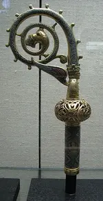
5) The staff is a Jesuit ( Catholic) Bishops staff. Crossier (?)

6) The trail leads directly to the Caballlo with three crosses, indicating 3 deposits on the East side, not Victoriio peak

7) The name of Tayopa is mentioned specifically three times on the LIL map..

8) The path is considered the most logical, the river was navigable in those days from The Caballo region down. water travel was considerable less dangerous, far faster, and cheaper. A slight detour north and 2/3 of the trip could be by water

9) The map was created around 1861, when the Civil War was about to start. The Jesuits knew that it woulld be very difficult to remove anything after, it would be declared American Sovereignty .They were closing the chapter on the Caballo deposits.

This wil do for a start, there are other points.:laughing7:

PS, the ores from Western Chihuahua and northern Sonora carry much copper, whih gives The Gold a rosy appearance.
 

Last edited:
Steve ,,

that dirt road from the Train Water Tank out to Ft. Cummings ,, is that still open to public travel
or did that Rancher shut it out ?

on GE ,I see a Tractor Trailer rig driving on it " Ha HA ,, too funny to see him out there "

is it open still ?
if so
directions to follow in PM

The road is still open.

Yes, Cuco is located in the Cookes Range. He's known as the Bogeyman. He's located at "Mine 6", where there is a filled-in vertical shaft above and behind the carving. Somebody removed about 15-20 feet of rocks and dirt from the shaft (well, ten years ago, anyway - the last time I was there), but abandoned the effort. There's a big heart shaped rock at the top of the shaft where they were working.

Heart 2.JPG
 

Okay. I have to step in here as someone who knows a bit more than your average bear about VP and the whole Noss Adventure.

NP:

First, Willie Daughitt and Buster Ward were the first two whites to find a treasure cave in the area in 1927. No matter how he obtained them, Willie used a map and sextant he got from the windowsill of an old house to find the cave. In it, there were over 2,000 forty pound bars of gold. Willie and Buster may have even killed a couple of people in the process of keeping their cave a secret. Willie was kidnapped and tortured twice by people trying to find his cave. Willie was friendly with Doc Noss. Doc actually helped Willie escape from his kidnappers the second time (maybe even killing the guy watching Willie). In gratitude, Willie let Doc examine the map he had found in his cave. It showed Willie's Cave and six other treasure caves. After doc was murdered by Charlie Ryan in 1949, Willie gave up the ghost. He took all the gold he could. Moved to San Diego and changed his name to Lawrence Foreman. He lived there mostly unemployed from about 1949 till his death in 1998. When he died, his estate was estimated at about $3.5 million.

VP was one of the treasure caves on the LaRue Map that Willie showed Doc. The family thought that Doc may have also discovered another treasure cave in the Caballo Mts, but kept it a secret from everybody after all the crap that had happened to his family over the gold in VP. Unfortunately, Doc was murdered before sharing his secret with anybody else that I know of.

NP, you are very sorely mistaken about so much of what you posted, I don't know where to begin. There were many people that assisted Doc in bringing out treasure from VP. One was Benny Samaniego. Doc gave him a Spanish Suit of Armor which he was known to wear for many public occasions and parades.

View attachment 985184

After assisting in removing several hundred gold bars from VP along with many artifacts, Doc have Benny a gold bar which he used to pay cash for the house that cost him about $10,000 (if I remember correctly).

You say that there are no witnesses to any gold in VP. That is incorrect. Capt. Fiege and Capt. Berlette of the USAF found a cave at the bottom of VP that contained piles of gold bars. We have the written results of their polygraph tests to prove what they say. We also have a sworn affidavit from an Army Military Police Capt Orby Swanner. He says that he personally witnessed the US Government flatbed something in excess of 93,000,000 (yes, that's ninety-three million) troy ounces of gold from VP before sealing it up. The military says he made it all up and was never there to begin with. GUESS WHAT?

When Operation Goldfinder opened up one of the large chambers, they found Capt Swanner's name sooted into the wall from a carbon arc lamp JUST LIKE AND WHERE CAPT SWANNER SAID IT WAS!

View attachment 985185

They were within feet of breaking into the deepest chamber when their time officially ran out. The Army took over the site, refusing to grant them any more time. They resealed it, just like it is today.

My best guess based on what I know is that there are at least three (maybe four) treasure caves still not found, and that they are spread out between the Organ, San Andres, and Caballo Mountains. Its a shame Willie's Map wasn't in his effects when he passed away....................... or was it?

Best - Mike

Hello Mike
Wow I must say your information is far far from what some of the Noss family have shared with a personal friend of mine who spent a lot of time with them my same friend also worked on the VP site. Doc took Josie Bell Butler into the Caballo "Sites" she also tells a much different account than what you share. I had another personal friend who knew Josie and who also knew Miss Perone. Both of which again share a much different story that conflicts with what you have shared here. I would imagine that over time many people pick up pieces of the stories and then get them mixed up and then repeat it over and over eventually believing its the gospel. Mike I can assure you Willie & Buster did not show Doc a map that led Doc to the VP. Willie & Buster did not find the map in a window sill. 17 year old Jack Reynolds found the map at Fort Seldon while foraging for fire wood by ripping the window sills and door frames from the old adobe fort trying to keep warm on a cold rainy night. He was ill with TB and was making his way to Hot Springs NM to be treated by Miss Perone. Long story short, Miss Perone obtained the map/s from jack while he was incapacitated with TB. She had the map/s translated that were of Castilian Spanish, Greek and Latin mixed. She had two copies made a set of maps for Jack and a set for herself. Miss Perone knew the are's mentioned on the maps and was familiar with the land marks there in the Caballo's. She sent Jack to the locations. Buster and Willie had already been getting into the mine/cavern close to Granite Peak. One day they caught Jack Randel coming out of the hole below or in Dark canyon and killed him stealing the set of maps that he had. Searchers looking for jack found his jacket at the bottom of dark canyon. Latter Willie and Buster told Miss Perone it was too bad that the boy had been mistaken as a deer by deer hunters and if she didn't stay out of the mountains she too could be mistaken for a deer. Meanwhile Willie & Buster now had additional maps/info of the mines/caverns within the Caballo range mainly Burbank canyon extending to Cable canyon.
Doc showed up in 1934 within 4 days located his mine/cavern from a map that he obtained from Geronimo in Fort Sill, OK. When he was 14 in 1908. Doc was born in 1894 not the BS dates in Wikipedia or wherever else the nonsense is repeated. A 1940 Hot Springs Census shows Doc's own writing indicating his birth year was 1896 but His Daughter Letha said Doc was always lying about his age and in fact was born in 1894.
The first site Doc Noss got into here in the Caballo's had found Spanish maps within it. Those maps showed him other sites within the Caballo range and at VP along with Cloudcroft, NM. and the Capitan mountains. Doc then began to fratenize with locals in the Hot Springs area. Trying to find out who else was getting into the other areas shown on his maps that came from his mine/cavern that he located in 1934. He teamed up with Leno Carteago to get into the Cable Canyon site then ran Leno off. Three men tortured Willie two of them were from Hatch, NM. And Doc was the third man who tortured Willie the first time. Willie told Johnny Gordon that one of them was Doc. I realize that is a surprise to everyone but Johnny Gordon owned the Ranch at Granite peak and was hauling Willie and Buster up to and back from the ranch with gold bars. Johnny Gordon's nephew Johnny Holden is the one who shared that with me. The people associated with the real events just shake their heads at all of this internet chatter that has gotten so mixed up. The Caballo mountains were full of murderers thieves and thugs all fighting among themselves. To the point they actually started working with one another out of shear protection from one another. The Palmer Brothers, Jack Palmer, Doc Noss, Willie, & Buster all met at Sonny Mitchel's house When Sonny was just a young boy. All the while Doc Noss kept the rest of them in the dark about his site that he first found from the Geronimo map. Things got really wild the Hebers and the Laurence's were looking to buy gold from this rat pack of murderers and were killed that's a long story anyhow that brought a lot of heat into the Caballo's so Doc left the Caballo's and went to Vickie Peak to get away from everything happening in the Caballo's. The whole story about that he & Babe was deer hunting and discovered a hole in VP is all BS! He new about VP since 1934 and then went to VP in 1936. However he always kept an eye on his first find in the Caballo's and the rest of the rat pack never knew about Doc's site. In 1942 Doc destroyed all of the markers associated with the mine/cavern and finally plugged the air vent that he was accessing. Most people familiar with Vickie Peak story never even heard of the Caballo's.
Anyhow I thought that you might enjoy hearing a little bit different take on the story about Doc in the Caballo's
Oh yeah I had a personal friend who brokered Leland Alsup's gold bars. Leland was Willies Nephew. My friend set him up with a Reno casino owner. They took the gold bars in to casino assayed them and just kept giving them chips until they would win the value of the gold. It took three years to take out all of the gold bars from that one location.
PS. I found Doc's camp site I dug up some of the things he stashed that his step Daughter Letha said that he buried. It was an old 1930's stove top, a stove pipe, a tin cup and a complete in tacked 1930's lantern with the glass globe broken but in place. Letha said he tore his camp down and buried those items. The same items that I dug up. My personal friend who spent a lot of time with Letha showed me the area to look for the camp. But Doc's original site is a long ways from his camp site. I even have Doc Noss' pocket knife. Am I an expert on Doc? Lol no where near it but I love the history and we should try to preserve it the best we can.
 

Last edited:
Hey thank you but it was a different map showing the Rio grande river and the Organ mountains Caballo mnts and VP
 

Hello Not Peralta No worries I am not offended. I am aware that Miss Perone was seeing Doc and Letha also, along with several other women. But I have to disagree with you about what Doc found where in light of Willie & Buster. What Doc got into had nothing to do with Willie & Buster. I am aware that Willie & Buster were already at Granite Peak before Doc arrived in hot Springs. My personal friend was a good friend of Letha's. Doc Got there in 1934 within 4 days was in the mine through an air vent. Doc kept his site secret from the rest of the rat pack in Burbank Canyon down through Cable Canyon. Doc did get mixed up with the rest of the rift raft in the Caballo's but it was after the fact that he already got into his mine site. This I know and if that conflicts with your understanding that's OK with me. Oh I am sorry that you are having trouble with your health I hope you are doing better. :-)
 

Hola Rog, but that is just a lil lonly cloud,, not a rock as you seem to believe.


Actually it's a hill. not a rock.
 

Last edited:
TM2,
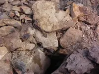
I think I see a lot of potholes, digging evidence here on this photo ?? I understand that means nothing at all if no one recovered anything from this site yet or maybe?
 

Top Member Reactions

Users who are viewing this thread

Back
Top