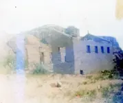
Do the Stone Tablets lead to somewhere OTHER than the Superstition Mtns?

Good catch txtea.I did not even see that.
If there where shutters they would have to be closed,and tight,or some light would show through.

Somero, the square in your yellow circle could be the stove clean out. Quite a few fire places are built like that in Superior. Clean out on the out side.
And it being in a corner would be out of the way from the doors,and main traffic area.

There is a compoany I believe in Tucson,or some where,remaking adobe block.It very expensive. But they do it by using 2x4 or 2x6 moulds. They look like a 4x8 foot rectangle, take a framed wall,then add some more fire blocking to make the bricks smaller,then ad 2- 10 foot studs on the outside frame to as handles to pick up the frame after the bricks have hardened some.

Here is a video on one person making them


Adobe walls can last a really long time, even if they are not protected. This was a surviving portion of an adobe wall that was built sometime around 1695. The picture was taken in 1961.


The visita was originally named Nuestra Senora de los Remedios de Doagibubig, after a settlement the natives called Doagibubig. There were never many people there. By 1730 the church was said to be "in ruins".

My source for all of this, including the picture, was "PATHS OF THE PADRES THROUGH SONORA" by Paull M. Roca.

Joe Ribaudo
 

mission painting.jpg

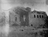
All of you realize, you are looking at a photograph of a painting taken through glass and not an actual photograph of a building taken within the past 70-80 years, don't you ? From some of the comments, I'm thinking maybe some of you don't.
 

View attachment 866372

All of you realize, you are looking at a photograph of a painting taken through glass and not an actual photograph of a building taken within the past 70-80 years, don't you ? From some of the comments, I'm thinking maybe some of you don't.

Kraig,

Believe that's been mentioned a number of times, but if you want credit for pointing it out, don't think anyone would care.

Joe Ribaudo
 

I am wondering for the painter who can paint hundreds bricks and thousands cobs .
A painting without signature ?
But maybe I am wrong , and the logic is replaced by obsession .

Mission.jpg
 

txtea

You wrote " One of the reasons I went to the Rendezvous in 2011, was to see if B.B. was going to show up and prove to everyone where he thought the Dutchman's mine was located. He came, he hiked to the spot he thought where it was, then admitted he was wrong. Hats off to ya, BB. "

Where BB thought the LDM was located ?
 

I don't know why there is so much discussion over a low res "picture" that was posted with absolutely no evidence of provenance and is undoubtedly not in the area of the supes (though I am commenting also). A building of that size does not go unnoticed in the history of the area considering most were little more than shacks.

I don't believe it to be a photo either. If it were taken for documentation during the turn of the century, the photographer probably would have had the sun to his back. IMO Looks more like artistic rendering to use shadows for contrast.
 

I noticed that building before..an it is similar to period construction...

but the oddities and the location are troubling.

a building of that size, can and will melt down...but there should be a rather large stain left in the area...
 

In all the research and investigations on this subject, has any actual gold ever been found? My grandfather really wanted me to go after this years ago, however I always thought that it was probably just a story. It sure looks like I was right.
 

there is gold in the area, it just doesn't have a sign posted "over here, dig three inches."

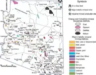
for those who wonder about mineralization in Arizona...draw a line from kingman to Clifton...you will notice a half moon sliver of mining districts along the line...
yes, there are mines outside this line...in southern Arizona...some scattered in other areas...
but along this imaginary line are the most productive copper, gold, lead, zinc, silver, finds in Arizona.

I was not going to post in this thread, but would add that my amigo Pippinwhitepaws is correct completely in this post. I will add a map from the AZ geologic survey, which is not the best but you can get the idea of what Pipp is talking about by the numerous mines marked.

Oroblanco
mineralmap.jpg
 

View attachment 866372

All of you realize, you are looking at a photograph of a painting taken through glass and not an actual photograph of a building taken within the past 70-80 years, don't you ? From some of the comments, I'm thinking maybe some of you don't.


If it can be confirmed that it is indeed a photo of a painting, all that does (imho) is lead to WAY more issues. Was it an actual structure or just an artists imagination? Who painted it? When? etc... Just too many questions to base any real foundation no.

As an aside, I think I recall Higham stating that he was a painter and left many of his portraits to the State Museum or something in the early 1900's - could it be that this was one of his? I couldn't find any of his paintings online to look at for style comparison.
 

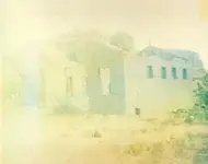
I'm feeding Not Peralta's cats while he's on vacation. I talked to him and told him about the controversy about the mission photo. He said that he had originally posted an enlargement of his photo. He told me where the pictures were kept and asked if the small picture might scan better. I tried it and you might notice a difference. I can assure you that it is not a picture of a painting.
img112.jpgThis is the enlargement that he posted originally.
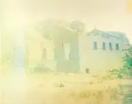
img185.jpg This is the original picture, NOT enlarged. You can see the difference as well as some stains on the paper.
Hope this helps, Dirty Boots for Not Peralta
 

I'm feeding Not Peralta's cats while he's on vacation. I talked to him and told him about the controversy about the mission photo. He said that he had originally posted an enlargement of his photo. He told me where the pictures were kept and asked if the small picture might scan better. I tried it and you might notice a difference. I can assure you that it is not a picture of a painting.
View attachment 867548This is the enlargement that he posted originally.
View attachment 867552 This is the original picture, NOT enlarged. You can see the difference as well as some stains on the paper.
Hope this helps, Dirty Boots for Not Peralta

Dear N.P./Dirty Boots,

I see no difference, size wise, between the pictures. The "Original" is the exact same photo, including the lines and arrows that he added, that Vastterrain posted. Can you explain?:dontknow:

Joe Ribaudo
 

Last edited:
txtea

You wrote " One of the reasons I went to the Rendezvous in 2011, was to see if B.B. was going to show up and prove to everyone where he thought the Dutchman's mine was located. He came, he hiked to the spot he thought where it was, then admitted he was wrong. Hats off to ya, BB. "


Where BB thought the LDM was located ?

Yes, I believe that was what he was claiming he knew the location of. What's the confusion? :dontknow:
 

Yes, I believe that was what he was claiming he knew the location of. What's the confusion? :dontknow:

Ok , maybe you didn't understood my question , and I ask again : Where ( in what location ) BB believed was the LDM ?
Thank you in advance and excuse my insistence .
 

How about some co-ordinayes for Google Earth of where BB location was.If someone has them.
Or can find the spot in GE and post them.
 

Top Member Reactions

Users who are viewing this thread

Latest Discussions

Back
Top