Do the Stone Tablets lead to somewhere OTHER than the Superstition Mtns?

trailraider

Personally , I believe how the temple exist . Is the omega in the stone map . The end point of the trail in the stone heart is the entrance of the temple . After the Aztecs , the temple was conquered by Apaches , who made the region below of the temple an sacred land . The gold of the temple , Apaches believed how belonged to God . To mark the sacred land Apaches made a totem ( a rock face ) and put it below the Omega , and little to the left of the totem , they carved a big rock to look like a rampant horse head ( maybe the horse of God ).
I post a picture from GE with the region where I believe is the temple

View attachment 792562

Have a nice day

Marius
 

Last edited:
trailrider, yes, there are a lot of cave systems in volcanic areas,and your right about the seven cities,the whole area im talking about now is volcanic, I like the story your talking about, the spanish man you once knew,I have not posted everthing yet,I like your sharing with me on this subject,and yes the truth is out there,IM going to ask a question in my next post ,pay very close attention to what im bringing out I want to see exactly how these people answer it.np
 

markmar,I agree,but the apache's were very active in a lot of differant area;s,
 

I have not seen any post on the LEADER STONE, BANKERS SIDE , theres a picture of it on page 71,in bob wards book ripples of lost echo's, np
 

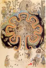
View attachment 790747markmar and cactusjumper, To a certain extent, I think you're both right. On the outside of my squared area of the map, my difference in opinion comes in where I believe the dots are the trail (and therefore not six days). The solid squiggly line is a representation of Spirit Mtn as seen from Christmas Tree Pass Road and hence could be a shamanistic interpretation. I would like to focus on the main map that markmar detailed in color in a previous post. I believe he is right in his interpretation to a point. I would appreciate any comments regarding the main map. Thank-you, NP
Hey Not Peralta, having fun again trying to solve a mystery. --- Map Analysis: On the map where the temple is supposed to be illustrated . Do the 'combined symbols' of this element show dimension depicting the difference between the vertical wall and the horizontal floor of the temple? --- Speaking hypothetically: #1: depicting the different between the vertical wall and the horizontal floor of the temple. Looking at the floor area of the temple; the dimension is shown by the lines representing the floor. The floor lines proceeding from the wall increase in width as they continue outward, depicting horizonal dimension. ----------------------------------------- ----------------------------------------- ---------------------- ----------------------------------------- ---------------------- ------------------------- The walls are depicted with combined 'dot' symbols closer together, depicting vertical height? -- Being different from the combined 'dot' symbols for 'foot-prints', for they are placed further apart? --- The 6 lines representing the wall of the temple could represent 6 pillars? -- The closeness of the 'dot' symbols representing the wall lines could be describing an object suspended in space, as a pillar. The space between the 'dots' of the wall lines could represent 'air-space', meaning - 'in the air'? --- The symbol for rain is illustrated in a cluster of small 'dots' very close together, but still leaving space between them. And rain drops are illustrated as being in air. ----------------------------------------- ----------------------------------------- ---------------------- ----------------------------------------- ---------------------------------------------- In conclusion: This element shows the division of 2 dimensions, indicating vertical height and horizontal length. The ultimate proof that this is indeed an illustration of a temple on this map, would be the finding of this temple, if it exists? -- If this temple does exists, and discovered by someone, 'it would be a find of a life time, the ultimate discovery!

'The adventure is just beginning', THE TRUTH IS OUT THERE
 

Last edited:
markmar,can you answer the question that trailrider is asking?,np
 

ok...YES gold can occur in veins as described....please study the gold mines in south Africa...the largest one is a series of plates...stacked upon the other...huge plates of gold ore...
it is possible for the vein to be as wide as the space for the hydrothermal activity to occupy.
 

---- Speaking hypothetically: Could these lost cities be caverns underground, formed by volcanic activity? -- Caverns of huge gold veins running through them?--

chicomoztoc.jpg volcano.JPG
 

trailride,thank you ,i agree.
 

I would like more info on LEADER STONE,BANKERS SIDE,np
 

trailrider

The pillars of the temples are composed by many pieces of the same rock , marble , etc. , Each piece have a hole in the middle . In these holes the constructors put a metal bar and after one by one the pieces of the pillar .

Marius
 

trailrider,yes the venture is just begining,np
 

markmar,thank you for providing an answer.np
 

trailrider

You wrote about the Spanish tresure hunter " The treasure hunter also had copy of a 300 year old map that he showed me, that had an illustration of the mountain he was searching and also depicting a certain gap in the mountain. This Spanish map showed a trail coming from mexico into this mountain range, this was his interpretation of the map. He knew how to interpret the Spanish writing on this map "
Perhaps he knew how to interpret the Spanish writings on the map , but he didn't knew to interpret the drawing in the map . Ever , a gap in the skyline of the drawing is a pit or tunel .

Marius
 

Last edited:
trailrider,markmar, one of philip coppens feature articles,the gold of gran paititi peru,the incan temple dedicated to viracocha,the creator god,pizarro and his men sacked the city of cusco,and the temple in 1533. this example describes what your talking about.np
 

View attachment 792631View attachment 792546 TIME PORTAL part #2


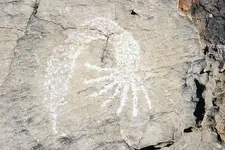
Map analysis {element resolution}: Most of us heard of the fabled ''7 lost cities of gold that the Spanish were looking for. Just because no recorded accounts of the explorers of Spain found any lost cities of gold, does not mean that it does not exist? If any of these lost cities existed, and the Spaniards did discover any of them. Would not they be regarded as top secret and any evidence of them kept hidden to this day? ---- Speaking hypothetically: Could these lost cities be caverns underground, formed by volcanic activity? -- Caverns of huge gold veins running through them?--The reported temples of gold were built right into these huge veins of gold? ----------------------------------------- ----------------------------------------- ---------------------- ----------------------------------------- ---------------------- ------------------------ The treasure hunter form Spain told me that it was reported that some where in the mountain, that some of the veins of gold, were pure enough and large enough, that you could cut out chucks of gold with an ax. I never before heard of such a thing, of veins of gold so thick you could cut it with an ax. The question I asked is this possible? -- It would be like in the movie, 'honey I shrunk the kids', where the grasshoppers were as big as giants. ----------------------------------------- ----------------------------------------- ---------------------- ----------------------------------------- ---------------------- ------------------------ Speaking hypothetically: These stories of underground 'lost cities with temples' may exist? Now looking at the Indian Petroglyph Map:

I like your map analysis, and thethought of under ground tunnels.np
 

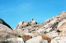
All the rock formation pictures that I previously posted, most, it can be argued are natural. This one has to be man-made.img005.jpg Remember, you can click on it for a better view. This is in Grapevine Canyon. What is someone trying to tell us by stacking these stones? It would have taken many men to lift these stones. NP
 

....What is someone trying to tell us by stacking these stones? It would have taken many men to lift these stones. NP

I wouldn't bet the farm that this isn't a typical balanced rock resulting from wind/weather erosion. I would bet natural.

If it is a monument, the top rock may have been placed. If so, judging from its size compared to the ankle to mid-calf sized brush nearby, it may weigh a couple hundred pounds - maybe much less (hard to judge from the photo). A couple guys could set it, maybe one if he could apply leverage.

Why a monument? Plenty of reasons. To mark a trail or some natural feature (pioneers, hunters, hikers, trappers, Indians, explorers, hippies, government guy, etc.). To mark a land parcel corner (surveyor, rancher, miner, etc.). For every 'real treasure sign' out there, I'd say there are 10,000 or 100,000 that aren't.
 

springfield,yes,i agree that it could be natural,yes,I agree the top stone could have been added with the aid of about 8 or 10 people because of its location, but it would make a permanent marker for any ones map.np
 

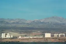
At the very center of the picture in the mountain range is the crescent moon. Be sure to click on the picture to enlarge it. NPimg134.jpgimg135.jpg
 

Top Member Reactions

Users who are viewing this thread

Latest Discussions

Back
Top