Do the Stone Tablets lead to somewhere OTHER than the Superstition Mtns?

coazon de oro ,cactusjumper.the stone tablets,say nothing about treasure,and my interpretation of the stone tablets,is differant than yours,its very simple ,if it looks like a duck,quacks like a duck,it must be a duck.maybe,thats why I found all my quackers .in one barrel.np

Well isn't that nice. :duckie::duckie::duckie::duckie::duckie:

Hope they migrate back to the Superstitions where they belong.
 

After all the back and forth on this thread, I've been struck by a few things:
The first arguement against my theory was that there never was a mission at the base of the Superstitions. There WAS, but that doesn't change the basics of my theory. The stone tablets don't lead to the Superstition Mtns just because they were found there.
I was told that there are LOTS of heart rocks in plenty of mountains. How many heart rocks are above a canyon containing a map? No one debated whether I found a map or not.
I was told I was "making up clues" to match the tablets. Well, isn't looking for clues what we all do?
My clues and markers just don't happen to be in the "generally accepted" area. I was even challenged on my use of the word "monument" to describe the large rock formations. I can't move these monuments to a place that it convenient for everyone. That is the challenge of my theory.
I respect honest debate but know some people will find any fault they can to minimize what I have located.
Once I searched the heart and found the map, I couldn't ignore the many additional matches to the stone tablets that I was seeing.
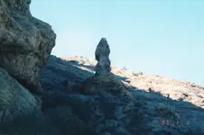
Instead of just telling me that there was no mission, shouldn't you at least be telling me that what I say could be a "priest" rock looks nothing like a priest? Or my "dagger" rock looks nothing like the dagger on the stone tablets?
Of all the people who have visited this thread - I wonder if anyone has bothered to come look. This area is so important that the Spanish sent Padre Fransico Garces here. (That's well documented.)
One final note: The definition of insanity is to do the same thing over and over expecting a different result. After 60+ years, isn't it possible that people are looking in the wrong place for the clues that the stone tablets contain? And remember, they never mention treasure, gold, silver or a mine OR Peralta or the name of the river.
Sincerely, Not Peralta please click on pictures to enlarge photo.thank you np
img006.jpgimg124.jpgimg001.jpgimg002.jpg
 

Last edited:
Not Peralta

The dagger is a sign and usualy is carved on a rock or is a ground outline . I don't believe is a 3D rock . The dagger show the direction to the target . Your direction is to the sky .
Look at www.mii.org/pdfs/legends.pdf to see some sings .

Marius
 

Last edited:
NP,

If you can send me your mailing address, I would be happy to show you the real priest standing 15 feet tall right where he should be, where the stones indicate. Not a could be, or wanna be priest, but the exact same one on the stones. Very visible 24/7, no squinting required, no mistake about it. I could also show you a video of hikers going right past receiving his blessing.

Homar P. Olivarez
 

Hi hunters

Why a priest to wear a sombrero hat ? You had see another same priest wear ? I don't think so .
IMO , the sombrero hat is a symbol of a ( known named ) peak or mountain and leads us at a specific point .
Unless you are searching for this sombrero

σάρωση.jpg

Marius
 

Last edited:
Not Perelta

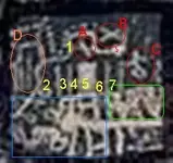
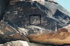
I want to describe some sings and symbols which are carved on the stone in your picture .

img124.jpg

In this picture the curved lines means travel and the up -down waves are days and nights . Are six days and because the last one the wave have corners that means how the last day are in a mountain range . Of course the trail go in the direction which is on the rock .

Sings.jpg


This picture show the end point of the travel . Is a temple which is in a high place on the mountain , but is underground . The icon in the picture it's like you see them first in order and have not conection with any orientation ( SNWE ) .

D ( orange circle ) : high rugged cliff - and the next peak is the temple - .
B ( red circle ) : entrance in the temple .
A ( red circle ) : Cross main room .
1 ,2 , 3 , 4 ,6 , 7 : main rooms .
5 : hidden main room .
C ( red circle ) : symbol which says how the treasure is hidden or is buried under the Cross .
Green square : symbols which represent warriors .
Blue square : symbols which represent a village ( many rooms and humans with their domestic animals ) .

I hope that helped you a bit .

Marius
 

Last edited:
markmar thank you for your comment and taking the time to look. np
ps: I believe the handle of the dagger on the stone tablets is a directional marker. Notice it points in a certain direction.
Try Google Earth 36*16'45.75"N 114*43'15.27" W and look for a rock pile.
also second rock pile on the other side of the peak 35*16'46.33"N 114*43'02.35" W
I beleive theres a tunnel going through the mountain np.
 

Last edited:
markmar and coazon, thanks for the hat trick.np
 

Not Perelta

I want to describe some sings and symbols which are carved on the stone in your picture .

View attachment 790160

In this picture the curved lines means travel and the up -down waves are days and nights . Are six days and because the last one the wave have corners that means how the last day are in a mountain range . Of course the trail go in the direction which is on the rock .

View attachment 790161


This picture show the end point of the travel . Is a temple which is in a high place on the mountain , but is underground . The icon in the picture it's like you see them first in order and have not conection with any orientation ( SNWE ) .

D ( orange circle ) : high rugged cliff - and the next peak is the temple - .
B ( red circle ) : entrance in the temple .
A ( red circle ) : Cross main room .
1 ,2 , 3 , 4 ,6 , 7 : main rooms .
5 : hidden main room .
C ( red circle ) : symbol which says how the treasure is hidden or is buried under the Cross .
Green square : symbols which represent warriors .
Blue square : symbols which represent a village ( many rooms and humans with their domestic animals ) .

I hope that helped you a bit .

Marius

Marius,

Another explanation of your first picture, "In this picture the curved lines means travel and the up -down waves are days and nights" is that it is a shamanistic interpretation of a phosphene. They are not uncommon in Native American rock art.

I have seen many examples of this exact design on pottery found at Snaketown.

Take care,

Joe
 

Last edited:
cactusjumper thank you for helping markmar,and your thoughts.np
 

Joe

" A phosphene is a phenomenon characterized by the experience of seeing light without light actually entering the eye " .
Light and dark , we are talking about the same thing . Light in the dark , is an radiography of the temple .

Marius
 

Don Jose

Yes , is fascinating and magic .
Is like you see something , but in fact is something else .

Marius
 

Joe

" A phosphene is a phenomenon characterized by the experience of seeing light without light actually entering the eye " .
Light and dark , we are talking about the same thing . Light in the dark , is an radiography of the temple .

Marius

Marius,

That, of course, is correct, but you need to find the meaning in relation to Native Americans. It is much less technical and much more spiritual. The real point is, it's found in many, many, Native American artifacts.

Take care,

Joe
 

After all the back and forth on this thread, I've been struck by a few things:
The first arguement against my theory was that there never was a mission at the base of the Superstitions. There WAS, but that doesn't change the basics of my theory. The stone tablets don't lead to the Superstition Mtns just because they were found there.
I was told that there are LOTS of heart rocks in plenty of mountains. How many heart rocks are above a canyon containing a map? No one debated whether I found a map or not.
I was told I was "making up clues" to match the tablets. Well, isn't looking for clues what we all do?
My clues and markers just don't happen to be in the "generally accepted" area. I was even challenged on my use of the word "monument" to describe the large rock formations. I can't move these monuments to a place that it convenient for everyone. That is the challenge of my theory.
I respect honest debate but know some people will find any fault they can to minimize what I have located.
Once I searched the heart and found the map, I couldn't ignore the many additional matches to the stone tablets that I was seeing.
Instead of just telling me that there was no mission, shouldn't you at least be telling me that what I say could be a "priest" rock looks nothing like a priest? Or my "dagger" rock looks nothing like the dagger on the stone tablets?
Of all the people who have visited this thread - I wonder if anyone has bothered to come look. This area is so important that the Spanish sent Padre Fransico Garces here. (That's well documented.)
One final note: The definition of insanity is to do the same thing over and over expecting a different result. After 60+ years, isn't it possible that people are looking in the wrong place for the clues that the stone tablets contain? And remember, they never mention treasure, gold, silver or a mine OR Peralta or the name of the river.
Sincerely, Not Peralta please click on pictures to enlarge photo.thank you np
View attachment 789928View attachment 789929View attachment 789930View attachment 789931
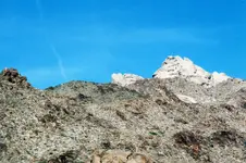
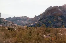
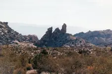
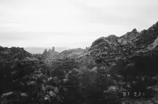
Hey Not Peralta, Thanks for sharing these pictures of old. Looks like evidence of the 'ancient-ones'. -- My supposition {opinion without proof} is based on {self-intuitive-evidence}. ----- Monument 'top-right' has {3-pillar shapes} incorporated on the end of the 'skyline-monument'. The {Aztec chief?} monument 'center' is looking down toward 3-other 'similar pillar shapes' {in a slanted position} displayed on the rock-cliff outcrop in back canyon. Looks like a ' U ' cut on the {left-side} of the top slanted pillar, similar to the skyline cut ' U ' on {upper right corner}. There are 3 small-humps displayed in the skyline ' U ' opening. The small humps represents 3-easy trails {easy on the animals}? The small hump on the left, is the highest trail? The skyline ' U ' also has a 'hoyo'{window}. I've seen many hoyo's at the 'Omega-sites'. ----------------------------------------- ----------------------------------------- ---------------------- ----------------------------------------- ---------------------- ------------------- You can see {white} eye-catcher boulders scattered over the back canyon.The hill on the left-side of the {entrance into the back canyon} has 2-boulder 'eye-catchers' close to each other. Also 3-sets of white boulder 'eye catchers' {left, center and right} of back canyon. One set of the 'eye-catchers' {right-side/back canyon} lead down to the area the {Aztec-chief?} is looking at, 'the area of the 3-similar pillars on a 45 degree angle, {slanted-left} with the cut out ' U ' symbol cut into the top slanted pillar. ----------------------------------------- ----------------------------------------- ---------------------- ----------------------------------------- ------------------------------------------ Speaking hypothetically: These monuments are an incorporation of 'ancient monuments and later combined Spanish monuments? The pillar 'monument-symbols' could represent the pillar of a 'temple'? The 2-boulder 'eye-catchers' on {left-side} of entrance of back canyon, could represent '2-eyes' {to look for 2-'eye-catcher' boulders? The 3-sets of 'eye-catcher' boulders {in the back canyon} could represent 3-entrances into the mountain? And if the Spaniards were involved, these entrances would be sealed shut {hidden}? And maybe heavily 'booby-trapped'? Don't know if this will help, just guessing. Good luck ----------------------------------------- ----------------------------------------- ---------------------- ----------------------------------------- ------------------------------------------- THE TRUTH IS OUT THERE
 

Last edited:
trailrider, thanks for your comments. i notice your interest in 3s. let me repost two more pictures from early in this thread for you to look at. Threes are important. npimg003.jpgimg111.jpg
 

img124.jpgmarkmar and cactusjumper, To a certain extent, I think you're both right. On the outside of my squared area of the map, my difference in opinion comes in where I believe the dots are the trail (and therefore not six days). The solid squiggly line is a representation of Spirit Mtn as seen from Christmas Tree Pass Road and hence could be a shamanistic interpretation. I would like to focus on the main map that markmar detailed in color in a previous post. I believe he is right in his interpretation to a point. I would appreciate any comments regarding the main map. Thank-you, NP
 

Last edited:

Top Member Reactions

Users who are viewing this thread

Back
Top