Do the Stone Tablets lead to somewhere OTHER than the Superstition Mtns?

NP,

... Look for title in the Index for; Chichilticalli, by Samuel O.L. Potter, see page 257. It is very important that you read this eye witness account.

One can actually go to this area and witness this anomaly in person. ...

Ellie B
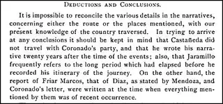
I assume you're referring to Potter's anecdote beginning on page 272, in which he describes a reddish rock formation that appears as a 'castle' when the light is right and is located in the vicinity (just north of the mouth of Pinal Creek) of some Indian ruins, cliff dwellings and an old saddle he dug up from a shallow grave. Map, page 273. Potter speculates that this is Chichilticalli, the 'red house' described by the 16th century Spaniards who explored present-day Arizona and New Mexico.

While I agree that Marcos was the wild card in the 'Seven Cities' saga at the time, and many Arizonans desire to place him in the Gila/Salt area, their efforts are speculative and the arguments are mighty thin. Potter's argument trying to link the 'red castle' rock formation to Chichilticalli is tough to swallow, especially since Coronado himself described the structure as merely a red-plastered ruin without a roof. Potter's 'red house' theory notwithstanding, he offers the following telling statement regarding the 16th century explorers' accounts of their routes (page 266):

Chichi.JPG
 

Ellie B,

With all due respect what he said and what I saw makes more sense than what you say. The old weathered copy of the H/P map he had was well used.

Good luck with your theory.

Tom
 

Springfield,

I agree with you 100%. I too do not believe that this structure is Chichilticalli. That honor belongs to the big house known as Casa Grande. Why Potter's story is important is that he shares with us the anomaly located in the Sierra Ancha specifically the red castle located high up on the cliff.

Frere Mark de Nice by Michael Nallino (2010) IMHO has written the best book about this subject. Unfortunately it is written in French. Below I have included additional information related to Sanford.

George Bliss Sanford, army officer (June 28, 1842-July 13, 1908)

Adamsville, AZ changed to Sanford, AZ in honor of this man.

Fort McDowell | (1865 - 1891), Globe. Situated on the "west bank of the Rio Verde seven miles above the junction of the Verde with the Salt River in Maricopa County".
"Fort McDowell [was] originally named Camp Verde (2) but quickly renamed Camp McDowell. Designated a fort in 1879 and became the Indian agency in 1891. Some ruins, one wall still standing."
Camp McDowell was established in 1865 and closed in 1890. This site was established by the United States Calvary to control the Yavapai and Apache Indians in the area.
"In the meantime, another prospecting party, headed by a saloonkeeper named Calvin Jackson, left Prescott on September 8. This party also intended to prospect in the same region. Both Cooley's and Jackson's parties were attacked by Apaches, and a cavalry patrol out of Fort McDowell, headed by Colonel George B. Sanford, therefore decided that the two parties should be united for their own safety. The two parties joined on 26 September 1869 near the mouth of Canyon Creek. The prospectors then explored up the Salt River for about thirty miles, but found no gold. It was about this time that Cooley decided that Thorn's story was "unreliable." He returned to Swilling's Ranch in Phoenix before November."


Globe Arizona History - "George Bliss Sanford, army officer (June 28, 1842-July 13, 1908).Born at New Haven, Connecticut, Sanford was commissioned a second lieutenant of the 1st Dragoons (1st Cavalry) April 26, 1861, and a first lieutenant July 30; he became a captain October 1, 1862. His Civil record was creditable, Sanford emerging a brevet lieutenant colonel after arduous service with the Army of the Potomac. In December 1865 he went with his regiment to California and thence to Arizona, where he remained about five years, much of it in command of
Fort McDowell. In September-October 1866 he led a scout and attack on an Indian rancheria, causing some casualties. June 3-4, 1869, he led a scout into the Pinal Mountains of Arizona, striking an Apache rancheria and killing about 20. He led other effective scouts December 10, 1869, and April 30 and May 25, 1870. In 1871 he moved with his company to California and from there to Idaho; he served briefly on detached duty at Sitka, Alaska. He was promoted to major June 25, 1876."Have a great week!Ellie B
 

Ellie B,

With all due respect what he said and what I saw makes more sense than what you say. The old weathered copy of the H/P map he had was well used.

Good luck with your theory.

Tom

Beauty is in the eye of the beholder. I was driving down the road and up ahead I noticed a knockout blonde hitchhiking, thumb out long hair blowing in the wind.

She was drop dead gorgeous and I was already rating her as a nine. She climbed in the van and closed the door. We started having a great conversation when I noticed a

strong sickening odor coming from her body and my attitude towards her quickly changed. Fantasy and reality are two different scenarios. What we believe will never change

the truth. I am not working with a theory.

Good luck to you Tom Dunkle

Ellie Baba
 

Springfield,

I agree with you 100%. I too do not believe that this structure is Chichilticalli. That honor belongs to the big house known as Casa Grande. Why Potter's story is important is that he shares with us the anomaly located in the Sierra Ancha specifically the red castle located high up on the cliff.

Frere Mark de Nice by Michael Nallino (2010) IMHO has written the best book about this subject. Unfortunately it is written in French. ....

That may be so, at least we know that Kino was at Casa Grande. I don't believe anyone has made much of an argument that Marcos or the Coronado expedition saw the site.

I agree Nallino is a good source, even though there are major questions surrounding Marcos still unexplained, including the 'missing time block' assumed to have occurred in 1539 when he was supposedly at Zuni but apparently was not. I have a couple of English translations of Nallino's papers I can send to you if you don't already have them (A Supposed Franciscan Exploration of Arizona in 1538: The Origins of a Myth, and Fray Marcos de Niza: In Pursuit of Franciscan Utopia in Americas).

Springfield,

I would be glad to take you up on your offer of the papers. Below is an important part of history as discussed by Father Kino and Manje;

Father Kino and Manje discuss historical and geographical mythology

COMMENTARY ON MARK OF NICE, 1 539- 481


Viceroy, Antonio de Mendoza, at Tonala, in New Galicia, Nov.
25,1538. We have these instructions, in Spanish, French,
Italian, and English, in divers records; also Friar Marcos' own
acknowledgement of their reception by him, as just said. Pur-
suant thereto, he left San Miguel de Culiacan, in Sinaloa, Mar.
7,1539. with his guide Stephen, his lay brother Honorato, and
the Indians. His course was by the highway northnorthwest
to Rio de Petatlan, the modern Rio del Fuerte, where Fray
Honorato fell sick and was left behind. Continuing the same
course, approximately parallel with, but at considerable distance
from, the coast, Fray Marcos crossed the Rios Mayo and Yaqui,
and about the middle of April was at a place called Vacapa or
Bacapa. This is specially to be noted; for the name has been
confounded with a certain San Luis Beltran de Bacapa, in
northwestern Sonora near the Arizona line, and thus Fray Mar-
cos has been sent by various writers promenading in a country
he never even approached, to the dire confusion of his whole
route. But Bacapa was an Indian village on the headwaters
of the Rio Matapa, about lat. 29", and was at or near the modern
town of Matape, in central Sonora, where the Jesuit mission of
San Jose de Matapa was founded in 1629. It was this miserable
malidentification of Bacapa, traceable back at least to Mange,
Mar. 12, 1702, which threw Friar Marcos' route out, altogether
too far to the northwest, at the hands of many historians or
commentators, who fetched him up low down on the Gila, made

'At this date, when Mange was with Kino at San Luis de Bacapa, he
indulged in the bit of historical and geographical mythology I wish to
signalize as such : " Y parece es por la que paso el ejercito de Francisco
Vazquez Coronado el aiio de 1540 cuando fueron a descubrir las 7 ciudades
de los llanos de Zivola, pues este nombre mismo le da el cronista Antonio
de Herrera en la de cada 4. a descubriendo este viaje, y que dista 40 leguas
del mar, y la misma distancia hallamos en ella," etc. Bacapa ! One day's
journey from Sonoita ! O Coronate .' Quandoque qualescunque quantcB-
cunque fabulce de te narrantur ! It all comes from mistaking this Bacapa
for the place on Rio Matape of the same or similar name, which happens to
be about the same distance from the gulf.

Father Louis Hoffman’s translation;

"And it seems that the army of Francisco Vazquez passed through (here) in the year 1540 when they went to discover the 7 cities on the plains of Zibola which is the same name that the chronicler Antonio de Herrera gives in each of the 4 ( 4 what?) discovering (discovered) this trip and it distances 40 leagues from the sea, and that is the same distance that we found it to be," etc. Bacapa! One day's journey from Sonoita! Oh Coronado, (here are 3 different possibilities)
1.- "when anyone speaks of you, it is of fabulous things (riches) (?)
2.- ..................speaks fabulous things of you
3.- when anyone speaks of you, fabulous (rich) things are mentioned

Frey Marcos took a wrong turn and had taken another route. Kino understood the so called error for Frey Marcos knew exactly where he was going as he was a seasoned navigator. He was hand picked for this job. Kino understood the History as Herrera had written it in the four volumes for the King of Spain. Father Kino also made a statement that the Seven Cities began at the Casa Grande on the Gila and that is why Frey Marcos made it a point to visit this spot (check out the latitude and longitude of the Casa Grande, a major clue). Father Kino was commissioned to produce a map that would define the Pimeria Alta region for the next 400 years. A drop of water for a dry parched tongue.

The plot thickens,

Ellie Baba
 

Last edited:
Springfield,

I just realized this is NP's thread. Sorry about that NP. I'll continue this discussion on the other Stone Maps thread.

Ellie B
 

Last edited:
Springfield and Ellie Baba,
I'm kinda glad you brought this subject up on my thread. A few questions: When Coronado's expidition had to split up because they found out the land ahead of them could not sustain their large party, they were entering a cactus bearing land. True or False? #2 The Spanish ship resupplying Coronado's party thought they were half way up the Grand Canyon, they didn't think they could go any further with their ships. Later it was found out that they weren't half way up the Grand Canyon but were in fact at the junction of the Gila and the Colorado rivers. That's where they dropped Coronado's supp;ies. True or False? #3 The Yuman Indians told them, when asked by the Spaniards, that the rest of the men went "UP" the river in the smaller boats. True or False?
NP
 

To Springfield and Ellie and Real del Tayopa,
Since Ellie thinks I need to learn more about what I'm talking about, maybe you'll find this interesting. Just happened to have it laying around. Enjoy, NPimg131.jpg
 

Springfield and Ellie Baba,
I'm kinda glad you brought this subject up on my thread. A few questions: When Coronado's expidition had to split up because they found out the land ahead of them could not sustain their large party, they were entering a cactus bearing land. True or False? #2 The Spanish ship resupplying Coronado's party thought they were half way up the Grand Canyon, they didn't think they could go any further with their ships. Later it was found out that they weren't half way up the Grand Canyon but were in fact at the junction of the Gila and the Colorado rivers. That's where they dropped Coronado's supp;ies. True or False? #3 The Yuman Indians told them, when asked by the Spaniards, that the rest of the men went "UP" the river in the smaller boats. True or False?
NP

NP,

Its been years since I have studied this material so I will make a number of educated guess's along with a number of comments. The problem as I remember was brought up before they left. The rest of the party caught up with the smaller group later. There is cactus all over the land of one kind or another.

Alarcon used boats to reach the mouth of the Gila once he had entered the bay. The worms were feeding on the bottom of his hull that's why he used his smaller boats. We know he passed the AZ line and had left some letters under a rock next to a tree he had marked. Melchor Diaz found his marked tree and recovered the mail. Alarcon was also told by the Indians the story of Marcos and Esteban.

They may have gone up the Gila or the Colorado. I do not remember. Melchor Diaz is soon to die from a self inflicted lance wound.

Anyway, that's the best I can do without opening up my books and I am way to busy to take the time.

Take care,

Ellie B
 

To Springfield and Ellie and Real del Tayopa,
Since Ellie thinks I need to learn more about what I'm talking about, maybe you'll find this interesting. Just happened to have it laying around. Enjoy, NPView attachment 784518

It is a very interesting map and I can understand some of the content. It has a lot to do with the location of Tayopa. Coronado knew about this mine and early on tried to reach the area and was thwarted by the impassable mountain ranges. I would need a better copy to read the finer print. Sonora, Gila, Rio del Norte and Santa Fe. This map covers a very large area.

I have never made a statement saying that you do not know what you are talking about. I made it clear that you need to document your claims. Proof is what I would like to see, not lip service. If you are telling us that there was a mission on Peralta Road you must prove it! Hearsay does not cut it. I could take a picture of any church in Mexico and tell everyone that it was once located at Circlestone next to the Reavis Ranch! Who in the hell would buy that statement? Hundreds upon hundreds of people used the Peralta Trail back in the late 1890's and beyond. Interesting that no one noticed a mission. Was it Jesuit, Franciscan, Dominican or a Mormon rest stop? Who was the priest and where did his congregation live. Were the Apaches at peace with the church during that time period? Search the Archaeological record and no church ever existed at any time north of the Gila River until after the Apache wars.

Nice exam and map NP, I appreciate both.


Ellie B
 

Springfield,

..... Frey Marcos took a wrong turn and had taken another route. Kino understood the so called error for Frey Marcos knew exactly where he was going as he was a seasoned navigator. He was hand picked for this job. Kino understood the History as Herrera had written it in the four volumes for the King of Spain. Father Kino also made a statement that the Seven Cities began at the Casa Grande on the Gila and that is why Frey Marcos made it a point to visit this spot (check out the latitude and longitude of the Casa Grande, a major clue). Father Kino was commissioned to produce a map that would define the Pimeria Alta region for the next 400 years. A drop of water for a dry parched tongue.

The plot thickens,

Ellie Baba

You made a good point - Marcos was well-known as an accomplished navigator. His first expedition (1538-39), which he shared with Coronado until Coronado became sidetracked west of present Durango, Mexico, is the only one of interest here. If he knew where he was going, it may have had to do with his guide Estevanico, who knew about the territory north of the Northern Frontier. IMO, Kino's knowledge of Marcos' expedition one hundred years earlier and his Casa Grande statement is a non-issue, especially since he was a Jesuit and Marcos a Franciscan. The Franciscans were the key players in the 16th century 'Cibola' saga, and Marcos is the joker in the deck.
 

Ellie Baba, if I lived back in that time period I could probably answer all those questions. The one thing I can tell you about it is that it was on the right hand side off of Peralra Road. Maybe a quarter of a mile. You would not have been able to see the ruins from Peralta Road. I already gave the directions on how to find it. If I still lived there, I could take you to the spot. But like I said, I didn't leave anything behind when I left and have no reason to go back. The last time I was there part of the foundation was still there and it didn't dig itself up. Page 59 of Ripples of Lost Echos by Bob Ward, is a picture of a rock that Bob found that has "DIOS" and an old mission sign on it. It was found right by the well by the mission. The Apache were not the only Native Americans living in that area. Thank-you, NP
 

Last edited:
Everybody following this thread for it's title: Please excuse the short detour to another subject. Someone didn't think my treasure hunting and map reading knowledge went beyond the stone tablets and I had to make a few points. My theory still stands. I couldn't help it because they got on this thread and started talking about something else. Feel free to talk here, I'm interested in lots of stories and theories. Curiously, a symbol from the map above is also found in the Spirit Mtn range. Thank-you, NP
 

Springfield and Ellie Baba,
I'm kinda glad you brought this subject up on my thread. A few questions: When Coronado's expidition had to split up because they found out the land ahead of them could not sustain their large party, they were entering a cactus bearing land. True or False? #2 The Spanish ship resupplying Coronado's party thought they were half way up the Grand Canyon, they didn't think they could go any further with their ships. Later it was found out that they weren't half way up the Grand Canyon but were in fact at the junction of the Gila and the Colorado rivers. That's where they dropped Coronado's supp;ies. True or False? #3 The Yuman Indians told them, when asked by the Spaniards, that the rest of the men went "UP" the river in the smaller boats. True or False?
NP

Like Ellie Baba, I don't remember all the details of Coronado's 1540 expedition (or care all that much). I know people strain to put his people in the Salt River mountains, and Utah too for that matter, but none of the arguments are particularly solid, IMO.

My interest lies with the Marcos de Niza/Coronado 1538-39 journey during which Coronado never progressed out of present Mexico, but Marcos spent time in present eastern Arizona and western New Mexico.

The map on post #272 is interesting, but looks very modern to me. It could have been made by anyone for reasons unknown - presumably to support the stone map theories.
 

Springfield,
The map came from New Mexico and had been there many years. That's all the information that I will ever give out. It has nothing to do with my theory about the stone tablets. (There is a symbol on the map that can also be found in the Spirit Mtn area)
NP
 

Last edited:
To Springfield and Ellie and Real del Tayopa,
Since Ellie thinks I need to learn more about what I'm talking about, maybe you'll find this interesting. Just happened to have it laying around. Enjoy, NPView attachment 784518

NP,

That's very impressive! Here's a map that I just happen to have hanging around.......since the sixties:


You should probably put your's in a bank safety deposit box for safe keeping.

A couple of other things. Do you have any more pictures of the mission, or the ruins? Do you have a picture of Bob Ward at his cabin?

Thanks in advance,

Joe Ribaudo
 

Last edited:
To Springfield and Ellie and Real del Tayopa,
Since Ellie thinks I need to learn more about what I'm talking about, maybe you'll find this interesting. Just happened to have it laying around. Enjoy, NPView attachment 784518

Not peralta

I feel your map was drawn yesterday and has no age. But its very interesting enough to peek my interest. It seems I was there not to long ago, Like yesterday, So your real name is!

Wrmickel1
 

Top Member Reactions

Users who are viewing this thread

Back
Top