Do the Stone Tablets lead to somewhere OTHER than the Superstition Mtns?

Howdy Mike,

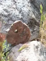
The hole you circled on the bottom bumper stone, is also missing on the red stones pictured on the grass. Could it be that they were just cast, and drying in the sun?:dontknow:

Homar

Homar,

The stones on the grass are the ones the molds were made from. That's why they have that red coating to them. Its the residue from the rubber molds. After you peel off the rubber, it leaves residue the same color as the molds that were cast. The stones on the grass are the same stones in the SMHS Museum.

My thought several years ago was that sometime between 1949 and 1969 a second set of engraved stones were made for whatever reason. Those were donated to the Flagg Foundation, and those are the stones we see today in the SMHS Museum.

Mike
 

Looks amazing to see the original and feel the weathering.....

must have been awesome to see them right when they were found.
 

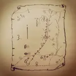
Here is a little thing I did a few years ago:

View attachment 1084204 View attachment 1084205

Mike

Mike,

Did not intend for the second part of my post to be directed to you in particular, as I am aware of that comparison you made, and in fact saved that post. Was trying to direct it to the discussion that most of the claims for forgery seems to be directed at the trail stones in particular which is moot as those stones are poor duplicates of whatever was put on that bumper.

Might it be that the real trail stones never left Texas?

Also to throw a monkey wrench into the discussion, what place does the Peralta Tesoro Mappa have in the discussion of the authenticity of the Stone Maps?
 

A paper map was used for the search. Not the stones. That paper map was the Peralta Tesora Mappa. I suspect that map was in Peg Legs collection. Travis got his hands on it and off they go. The map was used as a referral for the carver of the map stones leaving things off.
 

There is a second version of the Peralta Tesoro Mappa on display at the SMHS Museum.I believe it's attributed to Robert Garman.
Perhaps someone has a good copy they can post here.
Garman also had a somewhat translated waybill which has been previously posted.
Here it is again.....
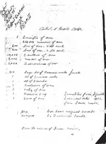
Waybill Bob Garmin.jpg

The Garman/Tumlinson relationship was also discussed some time ago on another site.

"Zentull
Post subject: Re: Peralta Stone Maps - Clarence Mitchell Era to the Present
PostPosted: Tue Aug 17, 2010 10:12 pm
Offline
Expert

Joined: Fri Aug 23, 2002 11:15 am
Posts: 1034
Location: Surprise, Arizona
The answer could be in the version Bob Garman told which is as follows:

He met Robert Tumlinson in Randolph canyon in 1955. Tumlinson was with 2 other guys and told Garman and his companion that they had some spanish treasure maps. Garman told Tumlinson he could stop by his house and Garman would see if he could be of any help deciphering them. Tumlinson said he would stop by for a visit but couldn't give Garman any info of what was on the maps cause Travis didn't want anyone else to know what was there.

Garman got to know Robert(He doesn't mention if he met with Travis) and said that Robert told him that Travis was on his way to Texas to visit his parents and pulled off the road for a look at the Superstitions and to see if he could see Weavers Needle. It was at this time he found ONE map. He took that map to Florence Junction and washed it off, after the bystander comment that it looked like a treasure map, he then continued on to Texas. His Dad couldn't figure out what he had, so they took it to a nearby university where someone said it was at least 100 years old. Travis did stop on his way back through, but found nothing else. The map he found was the Priest/Horse map.

Travis then made several trips looking for more maps with Robert, they believed there were more cause the 1st map said search for the heart. They finally found the Don and Cross stones and later found the heart buried deep below them......

If this story is correct then the photo could not have been taken at the first discovery, but explains why the priest/horse map isn't in the picture.

It can also explain how others came into the picture as they made a number of trips over time and while particulars of the stones were kept secret, they readily were telling their story by 1955.

Garman also mentioned that when he met Robert Tumlinson, that he was told they found the maps a year or so ago. Garman was sure of the year he met them and is a decent first hand witness, while he had interest in the stones, I don't believe he was very involved as he was generally prospecting for silver in the mountains.

_________________
"Be Careful of What You Do Before A Lie Becomes The Truth" "

"novice
Post subject: Re: Peralta Stone Maps - Clarence Mitchell Era to the Present
PostPosted: Wed Aug 18, 2010 4:46 am
Offline
Expert

Joined: Fri Mar 11, 2005 5:53 pm
Posts: 500
Location: Lake St. Louis, Missouri
Wayne,

I also believe Garman may be the best “early” source we have. I have his book (Published in 1975) and also an article that was published in the Superstition Mountain Journal written by Garman (Published in 1984).

The story you have told appears to be a slightly different version. Can you share where you took your story? I would like to run that reference down and bounce it off of Garman’s other accounts.

Quote:
You wrote:
He met Robert Tumlinson in Randolph canyon in 1955. Tumlinson was with 2 other guys and told Garman and his companion that they had some spanish treasure maps. Garman told Tumlinson he could stop by his house and Garman would see if he could be of any help deciphering them. Tumlinson said he would stop by for a visit but couldn't give Garman any info of what was on the maps cause Travis didn't want anyone else to know what was there.

From Garman’s book on page 18, Garman writes: “The author first met R. G. Tumlinson and his nephew in Randolph Canyon, Superstition Mountains in 1952. At that time they told me of the discovery of the stone maps, and at the same time pledged me to secrecy.”

Could this have been two separate incidents? Your story was in 1955 and apparently Travis wasn’t with Robert?

Rechecking my Garman references, I’m becoming more confused. The book I have was a first printing. I also have a copies of several pages, that Larry Webb provided me several years ago, from a Third Edition. In that book Garman had apparently added a dedication section in which he has a short story for Herman Pertach, Travis Tumlinson, Robert Tumlinson and Don Miguel Peralta.

I don’t see any glaring discrepancies, that might indicate, that Garman was trying to spin the story but I think Garman’s relationship with the Tumlinsons is interesting and I would like to put his accounts together as best I can.

Garry"

Both Wayne and Gary have done some very good research into the history of the stones and those who were involved in then early years.
My hat, as always, is off to them.

Regards:SH.

PS: It is my belief that the H/P stone and the red Heart stone on display at the museum are originals.
That the two Trail stones are copies, and all four were indeed the same ones that were donated to the Flagg Foundation.

Mike: As I recall, and I probably have a copy of it somewhere in my files, you once posted that when Mitchell handed over control of MOEL to the stockholders, Mitchell had two sets of stones. Mitchell gave them two which were copies and two which were original.
And that he kept two copies and two originals (as purchased from Aileen Tumlinson) for himself. Does this souind correct ?
 

Attachments

  • Garman's account 1.txt
    2.4 KB · Views: 86
Last edited:
Found it.....

"
Post subject: Re: The FIRST Set of STONE MAPS
Posted: Fri Apr 01, 2011 1:30 am
icon_user_offline.gif
Part Timer
treasurebar.jpg

Joined: Thu Apr 20, 2006 1:39 am
Posts: 479
Location: Southern California
Alan,

No idea. Jim Hatt came up with the idea to have the bonding agent tested, but the SMHS Board nixed that idea post-haste. Their reasoning was that it was their job to display the Stone Maps, not to verify their authenticity. HHHHHHMMMMMMMM

Wayne,

Check out the pics I have added. Without checking my records, I think it was Azmula that told me before MOEL broke up, Mitchell had an exact set of duplicate stone maps made up, kept two originals and two dupes for himself, and gave two originals and two dupes to Elgin Kriewald. As many people have outright dismissed this story, I never totally did. The comparison work I did on the Lower Trail Map looks like the stones on the bumper of Travis Tumlinson's '39 Olds just MIGHT NOT be the same Stone Maps that currently reside at the SMHS Museum. Now, granted, the old B&W Pic was damaged, so I left out what was not obvious:

1. In the old pic, there is what appears to be another hole to the left of the large hole. This smaller hole is not on the current stone.

2. What looks to be a long crack along the bottom of the stone in the old pic does not appear on the current stone. This is not a crease in the picture because if you look at the large old pic the crack starts at the left edge of the stone and ends at the bottom.

3. The little "M" mountain that is on the current stone is not on the old one. It's not like the lines don't exactly match up. The symbol is just not on the old one.

Now for my disclaimers. LOL For number one, there is a crease that goes through the picture right where that smaller hole resides. It is possible that it is part of the photo defect, but it does not look like it. Nothing for number two. For number three, it is remotely possible that the area in question is covered with dirt. It does not appear so, buuuut.

Now, I had to play with many facets of the old picture to get it's perspective to match my picture of the current one. In order to get a match, I had to adjust the following: Brightness, Contrast, Skew, Perspective, and Sharpness. This is the reason I did not include other small irregularities.

Conclusion: It is entirely possible that the Stone Maps in the old B&W Pic are not the same ones currently on display. IMHO

Mike
 

Last edited:
My take on the alterations added, were to attract investors after they searched the area in secret, and when telling their story they must have found an area that they wanted to search that looked similar to but not completely the same, hence rubbing off items of reference of land marks. They were looking for someone to either buy the stones or invest in their find to mine the area, so they altered them in case they could later find it themselves, or so they could keep the real clues secret, while they used others time and money to continue their search.

you said it yourself the original guy's intent was to include others to help but not tell them what was there, then they started telling their story later.....seems fitting for setting up a plot of some sort after not finding anything
 

There is a second version of the Peralta Tesoro Mappa on display at the SMHS Museum.I believe it's attributed to Robert Garman.
Perhaps someone has a good copy they can post here.

SH, might this be the one you are talking about?

IMG_5136.JPG


I am also happy to post the Peralta Tesoro Mappa if there are no objections?
 

To those I passed the Peralta Tesora Mappa on to I do not want it posted at this time. I have some new information I'm following up on that map.
 

In Part 1, this caught my eye....."Doc Rosecrans had a copy of the photograph of the maps on Tummilson’s car given to him by Tummilson himself."

Good evidence that one of the Tumlinsons...probably Robert was the original source of the "bumper photo".
Did Dr. Glover obtain the photo then, from Rosencrans ?
Joe ??
 

Last edited:
Thanks Frank.
Looks like Garman also thought the trail begins where the stones were found, along side US 60 west of Florence Junction, rather than where the Mexican was said to have dug them up. I was hoping one of his numbered items would be the "arrowhead" that is shaded in half way up the right side of the other "mapa".
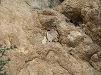
But no go in the list...or on the map in the book. I think it may be important, that as shown on the "mapa", it is depicted as penetrating the wavy line. I posted a photo of a peculiar arrowhead, along with the hole in the cliff that I found it in, some time ago.

Regards:Wayne


100_162 arrowhead hole.png View attachment square opening with X.bmp
 

Last edited:
I hope you smoked that hole out before you went in there....!!!

Thoughts of snakes give me the chills......and if I were a rattler, that would be the first place I would call home in the desert
 

In Part 1, this caught my eye....."Doc Rosecrans had a copy of the photograph of the maps on Tummilson’s car given to him by Tummilson himself."

Good evidence that one of the Tumlinsons...probably Robert was the original source of the "bumper photo".
Did Dr. Glover obtain the photo then, from Rosencrans ?
Joe ??

Wayne,

Been a little busy. We had 23 here for Thanksgiving and were a little busy.

I will ask Thomas if it's ok to give out that information soon.

Take care,

Joe
 

I hope you smoked that hole out before you went in there....!!!

Thoughts of snakes give me the chills......and if I were a rattler, that would be the first place I would call home in the desert

No snakes. Got lucky I guess.
Found this nearby, in between some white rocks. Pulled it out and took some photos of it.
Same stuff as the red heart stone.

marker stone.jpg

The hole isn't square like the one in the cliff. It's more like a triangle.
 

Last edited:

Top Member Reactions

Users who are viewing this thread

Back
Top