Do the Stone Tablets lead to somewhere OTHER than the Superstition Mtns?

Roy,

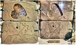
The Four Peaks are shown on the Stone Maps. It's a representation as seen from the ridge, thus not in the exact location on the stones.

The only way you know where Weaver's Needle is on the Stone Map Trail is to know the landmarks/canyons/trails all around it. That really takes time in the mountains to see it.

I will be happy to sit down at the Rendezvous to explain it and answer any questions......best I can. I'm not so interested as I once was.

We are looking forward to seeing you and Beth as well.:hello:

Take care,

Joe

Well, I am not convinced that saw-tooth marking really represents 4 Peaks. You even have stated one of the major issues with saying that is 4 Peaks - quote "not in the exact location on the stones" unquote; considering how well your solution to the map fits with the USGS topo, why should 4 Peaks be SO screwed up in location? That does not make sense to me.

I have read and heard many arguments to prove the stone maps must go to the Superstitions, but have never found these arguments convincing. The stone maps have many clear markings on them yet nothing for Weavers Needle, or Four Peaks (arguably of course) even though these are two of the principal landmarks of the region, visible for miles? Must be I have not spent enough time in the mountains to see it.

I have NO intention of eating up your Rendezvous time forcing you to try to re-explain the whole thing to someone as thick skulled as I am, really until someone has absolute proof that cannot be debated I will probably remain un-convinced that the stone maps MUST go to the Superstitions. As a side note here but did you ever see the Dillmans' solution to the stone maps, and how well it will fit for their spot in Utah? I am far from convinced that is "The" answer either, for by their solution those eighteen holes are much more than a days travel apart, which would not make much sense.

BTW those eighteen holes are really an ancient Golf Course; it was considered "The" most difficult golf course in all of Scotland, for you had to have an "in" with Henry Sinclair even to be allowed on one of his ships to get to America, and then the long and difficult hike to the Superstitions weeded out all but the very toughest Scot golfers. Par was considered to be 388, though that is purely hearsay, and people have been 'fudging' their golf scores even since the 1300s when Henry was around. Only the highest ranking Freemasons were allowed even to know about the secret Superstitions golf range, and this was the root of the name Superstitions too according to my (unpublished) source.
:laughing7:

Sorry about that, could not resist - and Joe if you would like to go over the stone maps again I won't throw a hissy fit.
Oroblanco

:coffee2: :coffee: :coffee2: :coffee2:
PERALTA_STONES_1.jpg
 

Roy,

My guess was that the majority of the Stone Maps was in fairly close proximity. I believe the first map was drawn from Superstition Peak. From there it's 20 miles to Brown's Peak.

Take care,

Joe
 

Ok,it is 34 miles from Baseline and 16th street to the stop light at the base of the main mountain.
This at Mountain view Rd.

Start point 33°22'37.51"N 112° 2'50.26"W
Head east on Baseline to I10. Turn left.
South to highway 60.
Right on Hw 60. East.
Stay on 60 until you get to stop point.
Stop point 33°22'57.67"N 111°29'42.98"W
Anyway, this is the straightest shot. Basiclloy, and if there was water in the salt.
Or just do east from his property. Same basic distance anyway.

I will have to see if i can find the article, but one web page said He was seen coming down center ave from the North.
With his mule.
 

Roy there are areas where you cannot see weavers needle or the four peaks.

Yes indeed - however, if you were going to carve stone maps for someone to later find your hidden treasure, wouldn't you include the two most famous and most visible landmarks of the area? It makes more sense to have those landmarks, than NOT to have them.

:coffee2: :coffee2: :coffee: :coffee2:
Oroblanco

Unless of course you wanted to make it rather difficult to solve the maps, then using smaller but recognizable landmarks only able to be seen in a general area could also make sense.:coffee2:
 

Yes indeed - however, if you were going to carve stone maps for someone to later find your hidden treasure, wouldn't you include the two most famous and most visible landmarks of the area? It makes more sense to have those landmarks, than NOT to have them.

:coffee2: :coffee2: :coffee: :coffee2:
Oroblanco

What makes you so sure they didn't ?

Weavers to four peaks.png

Of course, Weavers Needle might have been more needley than knobbley back when the stones were carved.:laughing7:
 

Somehiker , Sure. and ice cream didn't melt in the sun,:BangHead: np:cat:
 

Sometimes it don't....Why Walmart Ice Cream Sandwiches Don't Melt - Consumer Reports News

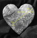
...'course, choosing a point somewhere along a direct line between two prominent landmarks would be both practical and logical, since those two would be unlikely to disappear before a recovery of whatever was hidden could be made. The precise location could then be marked both on their map and in the field by a simple geometric shape such as a triangle, with the orientation of the triangle also giving directional and other information. Makes sense....don't it ??

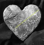
Have another look:

BW Heart 2.png
 

Last edited:
Somehiker, yes, it makes sense, but, what does not make sense, with whatever treasure that's out there would you not give easy directions to retrieve whatever it is that you want recovered, it makes absolutely no sense to make a map or give directions that you cant figure out, how would you ever be expected to recover something, unless it was a game or big joke or a set up for con game, or treasure hoax. np:cat:
 

Last edited:
The 18 hole are distance markers

Sarge

You have " catch " it . Are 18 marks every 47 meters , in the shape of the trail . No joke . This is the little stone trail ( in my terms ) which leads to the cave ( entrance ) to the underground rooms ( 6 - 3 to the North and 3 to the south ) full of gold .
The little stone trail starts where the bigger stone trail ( in my terms ) ends .
The bigger trail starts from the top of SW Superstitions , cuts two canyons , follow the third and the fourth for a short distance and cuts another two until ends . How I found the bigger trai , I have explained in other treads .
And now the CLUE . The Weavers Needle is recognized only in the bigger stone trail , with the triangle .
 

Why make it easy, when your map or directions could fall into the wrong hands ?
Especially if your cache is of great value , whatever it might be.
If a hoax or con game, it would have been far simpler and better organized, with all the pieces being found in a far shorter time span, from Abe Reid's Perficio Rock and book of psalms to Bilbrey's Stone Crosses, IMO.
 

Somehiker, very good example of why it should be easy;. stone tablets found when?
and how many years has that been?
how many people trying to figure them out?
well hows that working out?
that's just one example. np:cat:
 

There you go.. getting closer to finding that elusive golf course! :tongue3:
 

Why make it easy, when your map or directions could fall into the wrong hands ?
Especially if your cache is of great value , whatever it might be.
If a hoax or con game, it would have been far simpler and better organized, with all the pieces being found in a far shorter time span, from Abe Reid's Perficio Rock and book of psalms to Bilbrey's Stone Crosses, IMO.

1. Cache valuables in secure location.
2. Document location with foolproof proprietary system.
3. Protect location by creating diversionary tactics that will send nosy people around Robin Hood's barn in endless loops.
4. Relax.
 

Springfield, the next time I see little john in tights running around t or c , I will give him that information. ha ha , private joke for another post listing. np:cat:
 

Why make it easy, when your map or directions could fall into the wrong hands ?
Especially if your cache is of great value , whatever it might be.
If a hoax or con game, it would have been far simpler and better organized, with all the pieces being found in a far shorter time span, from Abe Reid's Perficio Rock and book of psalms to Bilbrey's Stone Crosses, IMO.

Not to mention the unlikely cooperation of a school teacher and two con men, all with self-serving interests, over the period of 70 years (1910-1980), to coordinate so that their "fraudulent" artifacts corresponded with one another (e.g., "SantaFe" which has no apparent relevance to the Supes).
 

Last edited:
Why make it easy, when your map or directions could fall into the wrong hands ?
Especially if your cache is of great value , whatever it might be.
If a hoax or con game, it would have been far simpler and better organized, with all the pieces being found in a far shorter time span, from Abe Reid's Perficio Rock and book of psalms to Bilbrey's Stone Crosses, IMO.

Wayne

Have you answered to me ? If yes , where you saw the " easy " ? Because I given the route after being decrypted ?
 

Wayne

Have you answered to me ? If yes , where you saw the " easy " ? Because I given the route after being decrypted ?

Sorry Wayne . I have misunderstood your post . You have wrote generally .
 

Somehiker, very good example of why it should be easy;. stone tablets found when?
and how many years has that been?
how many people trying to figure them out?
well hows that working out?
that's just one example. np

Abe Reid/ Perficio Rock and Jesuit book of Psalms with drawing of Cursum Perficio Map....1910-1920
Travis Tumlinson (who, along with those mentioned below, doesn't know about Reid's rock and map) /Three Stone Maps + Red Heart Stone....1948-1949
Bill Hidden or Charlie Miller and Robert Tumlinson ?/Black Stone (Latin) Heart....1954-1956
Michael Bilbrey and Ed Farr/ Stone Crosses....1977

Which makes it 57 years...minimum... for all the pieces of map to be found, all in the general area of the Sups.
And all in a line roughly between QC in the South and Four Peaks in the North.

Not too many people trying to figure out the Tumlinson stones until they we publicized in Life Magazine, just the Tumlinsons, Garmin, and a couple of others.
Even fewer knew about Abe Reid and the Cursum Perficio Map until about 2005.
Of course, after the article in LIFE, many more went searching. Like Bilbrey, a few may have had some kind of tangible results.
For me, it's been working out well so far.

Marius: I haven't spent much time exploring the area between Weavers Needle and Malapais, as my own interests lie elsewhere.
As of this October it will have been 18 years since my first hike in those mountains, with hopefully a few more left to go.
If I was to say the stones were "easy", it would only be due to what I have been able to find by being out there two or three weeks every year.
Not by someone else's "decryption".

springfield: "Protect location by creating diversionary tactics"
- such as making "mistakes" easily recognizable and understandable only to the intended end user ? -

deducer: "SANTAFE" as a state of mind or spirituality would be an asset to said end user.
Even more so to those who instructed the followers in a land where so many had became martyrs.
 

Last edited:

Top Member Reactions

Users who are viewing this thread

Back
Top