David and the Peralta stone maps.

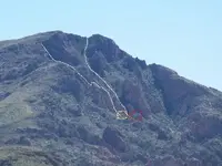
Hope you get a better idea from this.

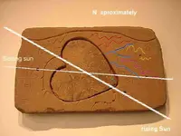
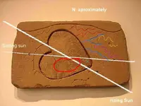
The green "X" is where you stand to see the rest of the stone map on the right/east side.
Blue lines are canyons.
Yellow lines show you the swirls in the rocks, where the minerals are normally found. top one is of 2 hills and the other lower one is the direction the swirl is headed to.
Pink is a rock layer that you follow to find another mine.
Red lines are canyons, just before the river.

The "X" also shows you where to stand to see the mine that is within the heart.
 

Attachments

  • heart_ hypothetical use.webp
    heart_ hypothetical use.webp
    35.8 KB · Views: 454
Don Jose,

"This to me suggests to me that all of the other stones are simply to locate and orient the heart stone. Once in position small sticks would be inserted into the two holes. The shadow from one cast by the rising Sun on as certain date would cross the other shadow line at a sunset from the other hole, also at a certain date."

You are not the first person to suggest this. I see multiple problems with such a suggestion, and always have. Overly complicated is the first thing that comes to mind. How and where do you place the stone to get the desired shadow? Guy would have to be some kind of genius to devise such a puzzle.

My solution does not need conjecture or imagination to prove out. The map itself is proof of the area it relates to. On the other hand, there may be codes that are on the stones that require more than a casual glance.

Because I am fairly certain who created the maps, I don't find them to be much of a mystery anymore. My answer to David will explain why.

Take care,

Joe
 

David,

I have been to many of the major places marked on the Stone Maps. One of the places that is marked by an X is a sealed mine on the ridge between West and East Boulder Canyons, just southeast of Willow Canyon. We did not open the mine or prospect.

Once you realize that the maps are modern-day creations, and who the likely "perps" are, you understand why the maps take in so many existing landmarks. The people who created them knew every treasure story that had ever been told about the Superstitions. In other words, they knew it's history, which is another clue.

One of the Xs, as you come off the Main Mountain, is an empty cave. At one time, I believe, it held Harry La France's gold bars. Do you know the history of that story?

You can't find that information with Google Earth, or even by spending time in the mountains. All of the stories have connections. The history is a huge web of information that keeps coming full circle back to many of the same players.

You have been working your way closer to the truth, but you are still a little mixed up. History is the key. If geology was the answer, the mystery you are trying to solve would have been over years ago. Forget about Weaver's Needle and start your research from Superstition Peak. I assume you know where that is.

The knife point rests on Parker Pass.

Good luck,

Joe Ribaudo
 

Say what you will.

I see how you found your areas and how you matched them up to fit. I understand that.

I have done the same and come up with a whole new view and area. Like you, i can fit them to a map and can show the markers just like you.

I will stand firm on my findings....
 

David,

As I told you, those kind of natural markings can be found all over the Superstitions, as well as all over the world. That's no great trick. Do they conform to the exact layout of the Stone Maps? Are they even to scale?

Join the club of people who have found crosses and hearts, as well as priests, circles in circles.....etc. All of them spent a great deal of time on the ground, where you eventually have to be to see it all.

Your theories are no worse than everyone elses. What most have in common, is no treasure, mine or ore. I say "most" because it's not true of everyone. :wink:

Good luck,

Joe
 

Joe;

Take a look at this please.

The "X" is the stand point and your are looking down the heart. If you use google to rotate, then you will see the hills and all. Look at the white area next to the mine. you can see parts of the trail fron google too.
 

Attachments

  • H.webp
    H.webp
    124.3 KB · Views: 444
I think that Somehiker and I have shown you that i can find mines without being there and just by maps that i see. So that blows your theory out of the water and still doesn't prove that i am wrong.


You guys are the biggest sceptics that i know, I am here to show you proof but, I will not just give it to you. Ask the right questions or show the interest and I might just give you a glimpse or two.
I have stated before that the stones have more then one way of looking at them. I mean that literally. once at the Heart, you look east from the point i showed you, to look west, you need to be on the other side and on the higher hump near the "V". From there you will see what is on the west side of the Heart. (On the stone that holds the heart stone).
 

David,

Your omaga sign is tilted the wrong way. It is much larger than your heart. None of the other markings are visible in your picture. Where is the curved line coming into the heart with the triangle at the end of the line?

Take another look at my map. Start with an unmarked topographic map, I assume you have one. Start at Parker Pass, the point of the knife, and begin tracing out the Stone Maps from that point. You can cheat with my map, but start with an unmarked one.

It's strickly a paint by the numbers excercise. Everything has to end up looking like the Stone Maps, so have them at hand.

Good luck,

Joe
 

David,

[What Omega sign???]

Sorry......That's how many people describe the hat shaped symbol that you have tilted the wrong way (in relation to your heart) on your picture. I keep forgeting that your relatively new to this whole thing. Put a copy of the Heart Stone right next to your marked topo.

Good luck,

Joe
 

No...
It's not the hat shape at all....it is the bottom part of the heart itself. look at the pic and see the area from google for a better look.

Again, i will say that you will never see the true picture, so keep that in mind.
I really don't want to show too much because i also found a place in the rock formation that has 3 rocks that stand alone and are in the formation of a triangle. one is light whitish/grey another is blood red and the other is dark brown. All three are standing out like sore thumbs.
These stones are reffering to what Jacob Waltz told of when giving his directions. Sadly i have forgotten most of the directions or things to look for. If i had the list again I could pin point this area too.
 

I wonder what the reason was for the "removable heart"? This seems to be some sort of a key to something and if it was removed the solution would never be found but it was found with the stones
so this would defeat the whole purpose of creating a removable heart. Why create this removable "key" and then just leave it with the stones to be found unless what is underneath is also very very important. It sure would be hard to create that heart space without leaving any no ticable chisle marks. Its just odd that someone went to a lot of trouble to create that removable heart and then not keep it seperate from the stone that it fits into, what kind of a way is that to safe guard a treasure map?
Bill
 

Quinan Bear said:
....
These stones are reffering to what Jacob Waltz told of when giving his directions. Sadly i have forgotten most of the directions or things to look for. If i had the list again I could pin point this area too.

I am truly sorry if I sound sceptical here - but you claim to know where the LDM is, but you have 'forgotten' Old Jacob's description??!!
Can you understand why people are sceptical?
That being said - I am impressed of what you have shown so far, and as far as I can judge, you have a good eye for picking out geological 'points of interest' from GE. However, I still do not believe the LDM can be found without extensive wearing out the soles of good hiking boots!! This - of course - is my own personal opinion; I might well be wrong ...
 

Loke;

I never said that I found the LDM, I just said that I found 3 rocks in a triangle.

What I recall on the directions to Jacobs Mine.
#1. If you pass the three red hills, you've gone too far.
#2. Two rocks, one on top of the other, marks the trail.
#3. There are two markers below, on the trail and one above the mine.
#4. Three stones in the shape of a triangle, marks the way.
#5. A square stone with an elongated corner marks the trail.
#6. There is an old stone home with no roof, near the head of a gulch, dicectly oposite the mine.
#7. The was the face of a man on the west canyon, oposite the mine, that looks into the cave.
#8. A spirit near by, sleeps 4 hours a day.
#9. From the top of a steep ravine to the east, you can see where 4 peaks to the north become one and weaver's needle to the south.
#10. From the cave, you can watch the people pass by on the trail to the east.
#11. There is a grassy nole above the mine, where you can keep the animals.
#12. No miner/cowboy will find my mine.

I forget the rest. and i don't know what order they go in.
 

QB,
I circled the OMEGA sign in red.
And Yes, it is an omega sign.
 

Attachments

  • heart_ hypothetical use.webp
    heart_ hypothetical use.webp
    36 KB · Views: 390
David,

If you are looking for meaning in the trail maps, you might want to consider the meaning and placement of the "Omega" symbol. As you travel the trail that starts at the one (1), or the beginning, the logical assumption would be that you are traveling away from the beginning and towards the end.........or the "Omega". Between the triangle and the "Omega", sits the circle in a circle. For all intents and purposes, that should be the prize.

In 1999, we went in specifically looking for the circle in a circle. I had marked its location on my topo around thirty years earlier, without having been in that area at all. This is what we found, right where I had it marked on my map:

CircleInACircle-1.jpg


Don't believe it can be found with Google Earth, but you could give it a try.

Take care,

Joe
 

I called them "eyes", I see some of these symbols near mines. I had circled this one in red, while trying to show Somehiker a mine area that was on the heart stone.
 

Attachments

  • tortilla.webp
    tortilla.webp
    27.3 KB · Views: 359
  • tortilla.webp
    tortilla.webp
    27.3 KB · Views: 367
  • eye.webp
    eye.webp
    70.1 KB · Views: 368
Here is a view of the heart, you will see all that is in the heart if you use google. This place has ALL the markers that are on the heart stone map and the heart stone itself. If you can't see them? then you're not looking, they are there.
 

Attachments

  • map heart.webp
    map heart.webp
    115.7 KB · Views: 368

Top Member Reactions

Users who are viewing this thread

Latest Discussions

Back
Top Bottom