David and the Peralta stone maps.

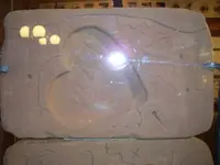
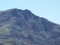
Here is one that you are free to use.Not the best because of the glass,but good enough.
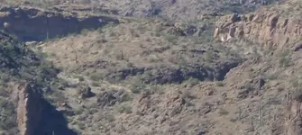
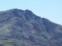
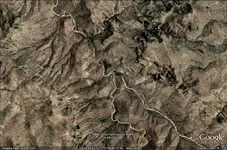
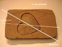
In my opinion,based on my own findings,topo maps and satellite views are useless.The maps are not views from above at all.They are perspective views of mountain tops and ridgelines as viewed and sketched by the designer of the maps as observed from various locations as indicated on the maps themselves.The various symbols are based on natural features that can be seen as indicated from those positions.Some have been enhanced,in order to make them more recognizable,like the "E" on the boulder,and the hole with the smaller hole above it.The only time that a top-down view is applicable is the relative direction that one is facing at that reference point.The hole next to the knife is not a mine,nor a cave.It is something else entirely,as are the two others I suspect,although I can't say for sure at this time.Looks like I will be looking for two solid objects slightly smaller in diameter though.
Regards:SH

edit:I see that CJ has provided some good pics as well.Heh Joe,hope you are well.No offense intended with the topo map comment.
 

Attachments

  • 100_0458sm.webp
    100_0458sm.webp
    18.8 KB · Views: 543
Somehiker;

Thanks for the pic of the stone. If you want to add a picture of the area that I have marked with a circle, from the place that is marked by a cross, here is my view of two angles from google facing northeasterly.
 

Attachments

  • X marks the spot.webp
    X marks the spot.webp
    90.5 KB · Views: 545
  • X marks the spot 2.webp
    X marks the spot 2.webp
    133.9 KB · Views: 561
Sorry,but this one is from a bit further north (on Malapais) of your cross mark.
I shoot a lot of panoramic views,360 deg,when I get high up out there.
If done in 12mp,they enlarge with good detail.
Comes in handy now and then.
SH.
 

Attachments

  • 100_0562_cr.webp
    100_0562_cr.webp
    149.6 KB · Views: 552
Here is one that shows a little more from a different angle.
Taken from a hilltop just to the south of the apache trail.
SH.
 

Attachments

  • tortilla.webp
    tortilla.webp
    27.9 KB · Views: 526
S.H.

No offense taken at all. There are many Dutch Hunters who feel the same way about my map as you do. I am always amazed at the number of people that claim they can read topo's, and yet can't see the correlation between the Stone Maps and a modern topographic map.......
even after I highlight it.

Here is another picture of the Heart insert:

Heart1.jpg


Hope these pictures help.

Take care,

Joe
 

SH,just a few random questions, if you know,or care to answer.
1-I thought there is only 1 horse"s head,the 1 the Indians carved after they eliminated the Peralta"s.
2-Are any of the directional stones still in the Saugaro"s the Peraltas placed there.
3-Is the outside covering of the white stone a mixture called caliche.
4-Do you know if a Peralta glyf is still on the bottom side of a ledge,showing a priest,a miner with candles in his hat,and other images.
5-Is it possible Ruth died from drinking from a tainted water hole.
6-Is our description of a mini volcano, a sunken valley,in Garden valley
7-Thanks to you, and anyone esles imputs.
 

Hi GD:
Don't know how much the Apache were into rock sculpturing themselves,but I think that they might have recognized one that nature had wrought,and taken note of it.There are a number of that type out there.I heard something similar recently,with the additional information that they were said to have carried it with them in their travels.The one in my photo looks kinda permanently located to me.
I have yet to find any stoned saguaros but I am always looking.Tons of them out there with slashes and holes though.Here is one that also has a line of different types of rock under the mesquite at the base.Looks pretty old.
The "stucco" could be what is called caliche.It's plastered over a rough surfaced boulder,follows the curves and fills the holes to make the surface smoother.There is layers of calcite in the area and pieces of rock that have calcite on one side or the other.
There are other places where a similar "cement" has been used.The big "P" on one side of the mound being one.
I don't put much faith in pecked glyphs that appear here and there.I haven't seen the ones that you describe.
Makes more sense to me,from the evidence we have available,that Ruth was shot by someone who believed that he had found gold.
Not Garden Valley.......elsewhere.I will put a photo up to illustrate.
Regards:SH
 

Attachments

  • 100_0294sm.webp
    100_0294sm.webp
    58.1 KB · Views: 529
And the "mini volcano" thing.From a higher peak.
It does show up on GE as well as a circular formation with two drainages.
Haven't put the boots on it yet.
Maybe it's a pushbutton for the "Finger of God".
SH.
 

Attachments

  • Dome 100_0208_cr.webp
    Dome 100_0208_cr.webp
    44.6 KB · Views: 524
A bit off topic,but I spent most of yesterday as a guest at a Ethiopian Christian Celebration.These are the ones that are said to possess the Ark of The Covenant.There was a replica of the Ark under the cloth on the small shrine within the curtained enclosure.
Regards:SH
 

Attachments

  • 100_0691sm.webp
    100_0691sm.webp
    26 KB · Views: 512
This facility hosted the event.
Felt like Daniel entering the lion's den when I saw this sign.
It's a Jesuit Loyola facility.I didn't mention the stone maps. :wink:
SH.
 

Attachments

  • 100_0673.webp
    100_0673.webp
    51.9 KB · Views: 574
Somehiker;

The picture that you posted of the area i mentioned, is not quite showing the right place (well right are but wrong view). I do however, see the area in the bottom center of the picture. It is the dark red/brown rock that is there.
This picture only confirms my findings. thank you once again...
 

Attachments

  • tortilla.webp
    tortilla.webp
    27.9 KB · Views: 484
I have seen your topo with the markers placed on it. I never said that it was not right, I just said that i don't read the stones as if they could be put on a topo map, I read them as if they were made from what they could see around them from one place. All your markers can be put in places that match the stone and mines are found as well, but it doesn't mean that my markers don't fit just as well.

Besides, wasn't it already pointed out that topographic maps or ANY maps of the area did not exist, just as sat views didn't exist then either. So, with that said. the way that these stones were made, was from a high point in the area (Weaver's needle).

It seems as though, you don't have as much knowledge as I do about mining and how the symbol of a mine came to be. I have given you the reason and added a picture to show you, now if you don't want to listen? and would rather mock something you don't understand, then that's up to you. I will not show you any more "tricks of the trade" that i know of, that will guide you to ore.....
 

I have added a few things to your photo, to help explain some things.

The white lines are steep ravines (lets say).
The yellow circle is a square rock with an elongated end. the red one is an eye that can be seen quite well in your photo. Follow up the ravine next to the square rock is.
 

Attachments

  • tortilla.webp
    tortilla.webp
    27.3 KB · Views: 486
G.D.,

"Are any of the directional stones still in the Saugaro"s the Peraltas placed there."

I have a letter written by my uncle, from back in the sixties, mentioning how Al Morrow showed him where the Cactus Marker was located. It had been destroyed, but the forestry had placed a marker at the location. The marker showed the directions of the stones that had been inserted in the cactus.
There was a flat rock on top of the marker, hiding it from vandals.

Chuck showed me the marker, but I am sure I could never find it again. My guess is that some of the old timers who live close to the mountains know it's location. I would ask Tom Kollenborn or Tracy Hawkins, if he is still around.

Good luck,

Joe
 

David,

"Besides, wasn't it already pointed out that topographic maps or ANY maps of the area did not exist, just as sat views didn't exist then either. So, with that said. the way that these stones were made, was from a high point in the area (Weaver's needle)."

As I have been telling people for years, as well as posting the information, the trail maps were drawn (primarily) from Superstition Peak, not from Weaver's Needle. Once you come to that realization, the entire trail map comes into focus.

If you have not been on the peak, it's not so obvious.......unless you have my topo to help you.

You can find crosses, hearts, circles in circles, horses, and every other marking found on the Stone Maps everywhere in the Superstitions. The trick is finding them in the exact places where they are shown on the maps.......and in spatial relation to each other.

The Stone Maps were made by people who had spent years in those mountains and knew them like the back of their hands. That made the creation of the maps much easier. It is likely that an artist carved them, such as Ted de Grazia. There were Topographic Maps.

One of the places that Tom Kollenborn shows on his map, is where the "Artist" drew the Stone Maps. It is one of the places where Ted de Grazia spent some (documented) time. That documentation can be found in "A Tiny Bit of God's Creation" by John L. Dahlmann.

It takes many years of research to put all the details of the Stone Maps together. Once you do, it's quite the story. It's all circumstantial at this late date, but the weight of the evidence is pretty convincing.

One of the more obvious clues can be found on page 126 of Tom Kollenborn's "Superstition Mountain: A Ride Through Time". It's a quote from Shakespeare's "Hamlet". It was one of Chuck Aylor's favorite passages and he would often recite it to guests: "You would play upon me; you would seem to know my stops; you would pluck out the heart of my mystery; you would sound me from my lowest note to the top of my compass".

Good luck,

Joe Ribaudo
 

Joe;

I see what you show me, i also see how it all fits together. I am sorry that you are not able to view my findings in their true form. I will however, tell you that the mine that Somehiker tried to show me a picture of, is really there and if he or someone else, could get a photo from the place that i showed on my pics, then you would clearly see the mine from there.

You guys are looking for my proof? There it is!!!. This is the dot seen on the heart stone as i said. Get that picture and i will show you the entrance.
 

David,

The dots on the trail maps are locator dots. They are all high points on the terrain. That can be proven by connecting the dots with straight lines. Those lines will run through map features that match the terrain features. Spend a little time studying my map.

What you are calling a mine(s), is more likely a cave. Big difference. Lots of caves in the Superstitions.

On the other hand, you may be correct. Only time and exploration will prove that. Can't be done with Google Earth.

Good luck,

Joe
 

Cactusjumper;
I have studied your map and i do see your connections with the stones. Now, I am assuming that you have gone to all these mines and caves that are listed on your map. Have you found anything in them that show of treasure or ore in them?

The places that i have found that the stone maps point to. Also point to a place where the rocks congregate.

When I first saw the stones. I did what you did. Then, i thought about putting myself in that time and that place, and making those maps myself. ( I put myself in his shoes).

If something were to happen to me? I would make it in a way to guide them to the places.
So, I put myself on top of a peak the stood out from all the others. I found this place by looking from atop of a peak on the Superstitions. from there i saw the "cross/heart and priest. I decided that it was the needle i needed to be at.

The reason why i didn't stay on the mountain itself, was because too many people would automatically think to go there as a starting point if they found the maps, but how many would trouble themselves to climb the needle? and what better place to have time to make the maps, without interuptions? This to me was a logical place.

Once this place is shown to you, you will see it all and it will be very obvious that they point to that area. If you saw the land as i do? you would see what i saw, as soon as i zoomed in on the area for the first time.
I started off at looking for signs of nature and mother earth. I looked for the tell tale signs for minerals and then I used the stones to see if they fit that area. Once i did that, i could pin point each mine and vault. You will all see in the end.
 

OK gentlemen since many theories are being thrown in, I will contribute. Since I have had no preconceived ideas etc., I am able to think outside so -------

Joe's last post triggered an idea. "you would pluck out the heart of my mystery; you would sound me from my lowest note to the top of my compass"

This to me suggests to me that all of the other stones are simply to locate and orient the heart stone. Once in position small sticks would be inserted into the two holes. The shadow from one cast by the rising Sun on as certain date would cross the other shadow line at a sunset from the other hole, also at a certain date.

For this to hold, there has to be two prominent peaks or mts in visual sighting when the heart is in the correct position. These would be the light / shadow source. The holes / sticks would provide the actual shadows tending to indicate the position of whatever the stones were constructed for.

Quien sabe ?

Don Jose de La Mancha
 

Attachments

  • heart. hypothetical use.webp
    heart. hypothetical use.webp
    29.6 KB · Views: 459

Top Member Reactions

Users who are viewing this thread

Back
Top Bottom