You are using an out of date browser. It may not display this or other websites correctly.
You should upgrade or use an alternative browser.
You should upgrade or use an alternative browser.
Basic signs and symbols you have found
- Thread starter Old Dog
- Start date


Shortstack
Silver Member
- Joined
- Jan 22, 2007
- Messages
- 4,305
- Reaction score
- 419
- Golden Thread
- 0
- Detector(s) used
- Tesoro Bandido II and DeLeon. also a Detector Pro Headhunter Diver, and a Garrett BFO called The Hunter & a Garrett Ace 250.
- Primary Interest:
- All Treasure Hunting
Lovnit:
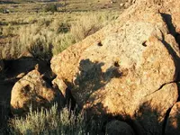
Any idea on what this sleeping head might mean?

Any idea on what this sleeping head might mean?
Old Dog
Gold Member
- #1,863
Thread Owner
lovnit said:Old dog I am really not sure what that is but the next time I go out I will take a picture of it, If it is a stump it would have to be a paloverde tree as thats all there is in this area.lovnit PS I will not be going out again until fall/winter as this is a very hot area.
When used as markers the stumps were made from a local hard wooded tree.
They will be cut with an axe and will be from 12 inches to 40 inches. The tree is most often killed as it will prevent alteration of the sign over time.
They are used as secondary trail markers and were not considered permanent as they could be destroyed by nature in an extreme circumstance. I have however seen them surviving wildfires year after year as well as floods etc... Many times outlasting the stone markers.
Clay Lindsey
Full Member
ThomasP,
For your drill holes, lie a piece of fabric over them. Then, copy the outline of the holes as carefully as you can onto the fabric. Then, place the fabric on a flat surface and measure the distances and angles for each side. When you get that done, we'll go from there.
Clay
For your drill holes, lie a piece of fabric over them. Then, copy the outline of the holes as carefully as you can onto the fabric. Then, place the fabric on a flat surface and measure the distances and angles for each side. When you get that done, we'll go from there.
Clay
Clay Lindsey
Full Member
Married life is great. Been playin pool cleaner guy for a buddy of mine. That job sucks... Just waiting on the vegetation to die off in the mountains to get back out there and play. I have a mild allergy to different types of grasses, so that last trip not to long ago was hard on me.
ThomasP
Jr. Member
I will try to get out this weekend. I been gimpy this summer and have not felt very good. but I will try.
There are alot of other signs and symbols clustered in this area with the drill holes. Hopefully it will all
come togeether.
There are alot of other signs and symbols clustered in this area with the drill holes. Hopefully it will all
come togeether.
Old Dog
Gold Member
- #1,869
Thread Owner
ThomasP said:I will try to get out this weekend. I been gimpy this summer and have not felt very good. but I will try.
There are alot of other signs and symbols clustered in this area with the drill holes. Hopefully it will all
come togeether.
Are there any associated signs that accompany the drill holes?
that would seem to answer a big question. Numbers in sequence ...
especially any combination of 1,2 and 3 or A,B,C.
Note size in the sequence as promenence
Old Dog
Gold Member
- #1,870
Thread Owner
ThomasP said:I will try to get out this weekend. I been gimpy this summer and have not felt very good. but I will try.
There are alot of other signs and symbols clustered in this area with the drill holes. Hopefully it will all
come togeether.
Sorry to hear you have been under the weather.
Hope you are back "up to snuff" soon and ready to hit your stuff.
You may have found a very good site here, be careful.
ThomasP
Jr. Member
Thanks for the concern and well wishes.
desertmoons
Bronze Member

desertmoons
Bronze Member
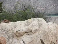
Well....hmmm...a key unlocks a door. A rock key would unlock a rock door..metaphorically speaking. I would think not a cellar trap door either..as this one is horizontal. A vertical door of sorts...to the side of this rock.
And ..of course there is the key to heaven idea...and mmm isn't one of the saints commonly represented with a key? Also during JC's absence,did not he go to Hell then came back and locked the doors of Hades with a key.
I guess i might take it as a directional and look all ways it could point but maybe look at the key end..the square part of that..not the handle end..and look where that squarish part is aiming.
Well..that is what i would do. lol
Old Dog
Gold Member
- #1,876
Thread Owner
Here is one of my thoughts on this marker.
There is a very steep bank in the distance, This just happens to be the North bank of the Gunnisson River. The river (concealed by willows right at this place) is about 75 yards across at this point. the marker sits on the very North edge of the Uncompagre Plateau. This may be one of the key markers showing the beginning of the trail that cuts south across Colorado, Southern Utah, Northeastern New Mexico and into Arizona, bypassing Sana Fe by several hundred miles. We have since found several markers of prominence that are at least as large (and just as weird) as this along this edge about every 12 miles. There is a route up onto the plateau near each.and always there are more monuments leading Southwest, that start to converge around the "Gateway" area they come together as one solid trail just before Monticello Utah. There are trails coming South from Western Utah that converge into this trail on the other side of the valley after they cross the Colorado River.
I think that these are the markers that the Escalante Expedition missed by Staying too far North of the Gunnisson.
These are very much the Alpha markers that would have written us all a different history.
Your "KEY" may still unlock a door.
Javaone
Full Member
Hey Old Dog – Great thread! 
Ranglers’ is pretty cool too. I had no idea how extensive signs could be. It’s mind boggling. Adds a whole new dimension to hiking, that’s for sure.
Here’s one I’ll throw out there – I’m thinking it could be a sun symbol…

Jerry
Ranglers’ is pretty cool too. I had no idea how extensive signs could be. It’s mind boggling. Adds a whole new dimension to hiking, that’s for sure.
Here’s one I’ll throw out there – I’m thinking it could be a sun symbol…
Jerry
Javaone
Full Member
Old Dog said:Hi Jerry,
Thanks for the contribution.
Do you by chance have a more direct shot of this?
Have enjoyed your posts on other threads, am looking forward to more.
Thanks Old Dog
Got that shot just before summer kicked in - didn't even see it until I was back home reviewing my pictures. It's a rough area, I have have spent three trips trying to plan the best route to get in there. When things cool off, I'll be back on it.
Jerry
Old Dog
Gold Member
- #1,880
Thread Owner
Looking forward to seeing as much as you want to show.
If it is a sun sign it will be very clearly evident.
Note that if it has no rays it is telling you to go West. There will be other signs and symbols that give distance.
If it has rays it is telling you to go East. The number of rays will give you a distance.
If it is a sun sign it will be very clearly evident.
Note that if it has no rays it is telling you to go West. There will be other signs and symbols that give distance.
If it has rays it is telling you to go East. The number of rays will give you a distance.
Top Member Reactions
-
 2257
2257 -
 1484
1484 -
 1307
1307 -
 1302
1302 -
 1062
1062 -
 964
964 -
 811
811 -
 649
649 -
 630
630 -
 537
537 -
 527
527 -
 506
506 -
 498
498 -
 482
482 -
 438
438
Similar threads
Users who are viewing this thread
Total: 1 (members: 0, guests: 1)
