Basic signs and symbols you have found

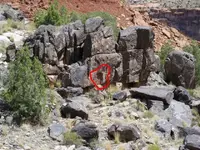
Another angle on the subject of the square rock plugged hole. Could it have been simply a cache site for EQUIPMENT or dried food? I mean, it isn't designed to be "invisible". Maybe it was designed to keep wild animals away from a food pack (jerky) or extra equipment such as pouches of flints and steel, shovel heads, pick heads, etc.
 

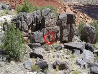
Here is one of the ones that I have found with the plug removed.
A solid wall behind it.
At the 3:00 position and 9:00 position are a pair of owls.
But no other marks to speak of.
 

Attachments

  • Square marker.jpg
    Square marker.jpg
    103.4 KB · Views: 777
  • Square marker.jpg
    Square marker.jpg
    103.4 KB · Views: 753
suppose that could have been the spanish mail box system in case there was a need of some kind?. :dontknow:
 

I personally don't think Square markers of this sort are Spanish.
The owls however may be, These are in an area that runs parallel to a very distinctly marked Spanish trail.
 

Thom,
I see the Owl at 9. Peg 'A' seems like it could have come from slot 'B'. However, the distance from 'A' to 'B', plus the nearly level appearance, makes me think that it was pulled out and layed to rest in a meaningful direction. Could the 'plug' have been a set of instructions that would have be used once reaching the location indicated by the pointer stone?
 

Mike,
The "plug" is missing all together.
There seem to be a multitude of these square markers of varying sizes up and down this canyon.
Some are marked as well by the Spanish, Others have the plugs pulled and stand as empty as this one.

One of the resons I potographed this one is because of the specialty signs included, and their positioning.
There are puzzles of all kinds in these trails.
Welcome to one of mine.
LOL
 

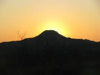
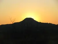
Just thought this bit of beauty was interesting. Strange notch in the mountain side, ja? Found it just up the road from the triangle rock arrangement from a different post.
 

Attachments

  • MountainNotch.jpg
    MountainNotch.jpg
    9.6 KB · Views: 632
I thought you might enjoy that, Thom. Truth be known? I never noticed that until just before I uploaded it. I was going through a jump drive to see if I had any pics to salvage. Not having had a clue at the time about anything sign related, as with the triangle rocks, I just captured the moment and moved on. Yes, they certainly do stand out! OH, the things I now know I have missed!
 

Heheh okey...i will say this..you sure know how to make a girl happy. :icon_thumleft:

Those are gorgeous! So lovely!

That shelter..if it is man made...is interesting. Not really big enough to sleep in or is it? Well blackened ..i wonder if water or smudgy fire did that.

There seem to be a campground across from it on the "island"

The boulders in it seem purposely placed...maybe. There seems to be at least one suspiciously squarish like carving. Then that hole lower right.

The water level could have been a lot higher back then.

My first thought would be...trail marker of some sort and important because of campground there. I can not think of any manufacturing process that would require a shelter like that! I mean the flow of water does not seem like it would cross the shelter interior.

I wonder if you are suppose to stand on it for some reason.

Awesome pics!
 

hadji009 said:
spanish or wishful thinking?
Native American mano and matate were then used to grind the corn. A matate (or metate) is the large stone on which the grain is placed. A mano is a smaller stone tool (or rock) used to grind corn or other grains. It is rolled over the matate to break down the grains into a powder.Dried corn kernels were placed on the matate, a large stone. After years of use, the matate developed a groove, allowing archeologists to determine roughly how often the tool had been used.
 

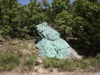
A fellow employee heard me talking about animal shaped rock and said he knew where there was a frog about 12 miles away. During lunch I grabed my camera and 26 miles later took pics of this frog. It looked so much like a frog the locals painted it. It is within view of a major river and is looking parallel to the river at the edge of a road. A car had hit it and reconstruction was done on the eyes. Looks like an "x" on the side. What say ye?
okey dokey
 

Attachments

  • frog1.JPG
    frog1.JPG
    466.8 KB · Views: 464
  • frog2.JPG
    frog2.JPG
    169.4 KB · Views: 462
That sure is a good frog Larry,
Wonder what it looked like before it got hit by a car and painted by the locals. LOL

You pretty much have a handle on why they would use a frog.
I do know of one on a semi dry mountain top but it is still within a quarter of a mile of a creek.
 

well Old Dog it was truly an honor and a grand pleasure to have a cuppa with ya and finally get to hug ya a time or ten! lol As promised, I will get caught back up on the thread now that CTH 3 has wound down and get back in student mode! I will also go check the other link too! Love ya buddy! ~hugs~
 

Cynangyl said:
well Old Dog it was truly an honor and a grand pleasure to have a cuppa with ya and finally get to hug ya a time or ten! lol As promised, I will get caught back up on the thread now that CTH 3 has wound down and get back in student mode! I will also go check the other link too! Love ya buddy! ~hugs~

It was very nice to see not only you, But Brian and Danni as well.
I really enjoyed Danni, she will grow into a true beauty.

The honor was truly mine.
 

Mike.

Were you ever able to get back to this cut in this mountain?
I would be interested in seeing the next and the last signs as seen from here.
they should be readily viewable unless they have been removed by erstwhile hunters looking to tear down history.
 

Attachments

  • MountainNotch.jpg
    MountainNotch.jpg
    9.6 KB · Views: 1,777

Top Member Reactions

Users who are viewing this thread

Back
Top