Video 4 - The Peralta Stone Maps with Frank Augustine

One thing I never posted was probably the most valuable of all I found. I'm still researching it.
It seems to be possibly a hubcap from a 1939 Oldsmobile missing the center emblem!
What was the car Travis was driving in?

This is another Video from the old highway 60 bridge at the Silver King road turn off. Listen and you can here the arcing of the high voltage lines above.


Same drill holes I posted from down here and in the Estrella Mountains site of a Massacre. It was used for splitting rocks the free mason way. Without dynamite or black powder. Just a small hand drill and some rock mason knowledge.


Recently discovered in Galena Gulch
View attachment 1169534
 

More like Climate (Wardrobe) Change. That looks like one large Arrastra! I've seen them as small as a campfire but never that huge. It must have been for Oxen or teams of Mules. Or water powered if there is a nearby source.

Bless you guys. It looks like your all dressed for cooler weather.
Acclimation.
 

We have been talking about the Travis Tumlinson Peralta Stone map discovery site and I wanted to offer four sources that describe how Travis came to find the first map.

1.
“The Lost Dutchman mine of Jacob Waltz (Part 1: The Golden Dream)” Page 338, by Dr. Thomas Glover

“On his way back to Oregon, Travis had driven through Arizona. Shortly after passing Florence Junction heading west he stopped the car at a little rest stop right by Queen Creek. After a while he needed to relieve himself, and climbed up the embankment for privacy. Once on top he was walking around stretching his legs when he literally tripped over something…..”

Provenance: Travis Tumlinson to Robert Tumlinson to Dr. Gene Davis and recorded by Dr. Thomas Glover.

2.
“Superstition Treasures” Chapter 4, Page 23, by Clarence Mitchell aka Travis Marlow.

“Jack and his family were on vacation, going through Arizona to Texas.

“He had heard about the Superstition Mountains and especially Weaver’s Needle.

“Having plenty of time he started to look around a little. Driving back off of the main highway for some distance, he stopped his car and walked out on the desert. He then decided to walk up a small mound or hill to see if he could see Weaver’s Needle from there.

“He stumbled onto something protruding from the ground,….”

Provenance: Travis Tumlinson or Aleen Tumlinson to Clarence Mitchell and recorded by Clarence Mitchell.

3.
“Hanier-McGee Correspondence” (Letter dated August 6. 1971) [Pat Hainer to Bernice McGee]

Travis showed us theses maps that he, himself, had found while out hunting arrowheads.”

Provenance:
Travis Tumlinson to Ken & Pat Hainer

4.
“Richard Peck Correspondence” (Letter dated April 12, 1965) [Bert Love to Rick Peck]


Bert Love interviewed Bob Schultz who was a friend of Travis Tumlinson in Hood River, Oregon.

An excerpt from the letter:

“Bob said that Travis found the stones along the Apache Trail. He was all alone when he found them on his way to Oregon near Christmas time. His car ran low on water and he pulled the car over to the nearest spot on the highway to Queen Creek. There was a fence between the road and creek with part of the fence down. Travis found a Prince Albert tobacco can and used this to water carry from the creek. He had to make many trips through the hole in the fence. Three or four times he stumbled over a protruding rock brick near the opening in the fence……”

Provenance: Travis Tumlinson to Bob Schultz recorded by Elbert Love

The above are four accounts that provide us some kind of source for the actual Travis discovery, of which I am aware. I believe all can be traced to Travis as the source. Of course errors could have crept in during the retelling and almost assuredly did. We can all see some possible errors and it would take a very “trusting” person to believe that all four stories are true.

It certainly raises a “Red Flag” as it appears that Travis is changing his story over the years. I suspect he never envisioned that a bunch of critics would be poring over every word.

Many Treasure Hunter’s will simply ignore the discrepancies in these stories as a nuisance and return to solving the maps.

Others will cherry pick the description that best fits their scenario of the map story or insist that the discrepancies have no impact on the basic buried map story.

Others will say that since Travis couldn’t come up with a consistent story it lends weight to the idea that the maps were never buried anywhere.

Whatever your bent, these four stories can probably be spun any of a dozen ways.

Garry
 

Last edited:
That's even the same type of rock they drilled in all four area's I've found those types of stones it must their favorite for drilling. Kind of a gray sandstone brittle material with small seams of quartz.


View attachment 1169534
 

I believe I've looked behind the old Queen Creek gas station and store too. If his car overheated and he needed water from the creek Queen Creek was way to far down for that scenario. But when Mike interviewed Janie Tumlinson she insisted her Dad was telling the truth and the maps were real. So he may have kept the location secret for a reason. He thought he might find more maps or artifacts there so only he and his family knew the exact spot.
The Pee story would probably keep it close to the road as he wouldn't have gone that far. The Arrow head story puts it out farther in the middle of somewhere and the hill story narrows it down. Personally I think finding some sort of clue like the hubcap could spill the true story. But how many oldsmobiles drove along that highway from then until now?


If he would have just left us a note or clue somewhere someone could find that said ah ha Travis was here!

No such luck!


We have been talking about the Travis Tumlinson Peralta Stone map discovery site and I wanted to offer four sources that describe how Travis came to find the first map.

1.
“The Lost Dutchman mine of Jacob Waltz (Part 1: The Golden Dream)” Page 338, by Dr. Thomas Glover

“On his way back to Oregon, Travis had driven through Arizona. Shortly after passing Florence Junction heading west he stopped the car at a little rest stop right by Queen Creek. After a while he needed to relieve himself, and climbed up the embankment for privacy. Once on top he was walking around stretching his legs when he literally tripped over something…..”

Provenance: Travis Tumlinson to Robert Tumlinson to Dr. Gene Davis and recorded by Dr. Thomas Glover.

2.
“Superstition Treasures” Chapter 4, Page 23, by Clarence Mitchell aka Travis Marlow.

“Jack and his family were on vacation, going through Arizona to Texas.

“He had heard about the Superstition Mountains and especially Weaver’s Needle.

“Having plenty of time he started to look around a little. Driving back off of the main highway for some distance, he stopped his car and walked out on the desert. He then decided to walk up a small mound or hill to see if he could see Weaver’s Needle from there.

“He stumbled onto something protruding from the ground,….”

Provenance: Travis Tumlinson or Aleen Tumlinson to Clarence Mitchell and recorded by Clarence Mitchell.

3.
“Hanier-McGee Correspondence” (Letter dated August 6. 1971) [Pat Hainer to Bernice McGee]

Travis showed us theses maps that he, himself, had found while out hunting arrowheads.”

Provenance:
Travis Tumlinson to Ken & Pat Hainer

4.
“Richard Peck Correspondence” (Letter dated April 12, 1965) [Bert Love to Rick Peck]


Bert Love interviewed Bob Schultz who was a friend of Travis Tumlinson in Hood River, Oregon.

An excerpt from the letter:

“Bob said that Travis found the stones along the Apache Trail. He was all alone when he found them on his way to Oregon near Christmas time. His car ran low on water and he pulled the car over to the nearest spot on the highway to Queen Creek. There was a fence between the road and creek with part of the fence down. Travis found a Prince Albert tobacco can and used this to carry from the creek. He had to make many trips through the hole in the fence. Three or four times he stumbled over a protruding rock brick near the opening in the fence……”

Provenance: Travis Tumlinson to Bob Schultz recorded by Elbert Love

The above are four accounts that provide us some kind of source for the actual Travis discovery, of which I am aware. I believe all can be traced to Travis as the source. Of course errors could have crept in during the retelling and almost assuredly did. We can all see some possible errors and it would take a very “trusting” person to believe that all four stories are true.

It certainly raises a “Red Flag” as it appears that Travis is changing his story over the years. I suspect he never envisioned that a bunch of critics would be poring over every word.

Many Treasure Hunter’s will simply ignore the discrepancies in these stories as a nuisance and return to solving the maps.

Others will cherry pick the description that best fits their scenario of the map story or insist that the discrepancies have no impact on the basic buried map story.

Others will say that since Travis couldn’t come up with a consistent story it lends weight to the idea that the maps were never buried anywhere.

Whatever your bent, these four stories can probably be spun any of a dozen ways.

Garry
 

This was the site that Frank and I had maps too that showed it on the east side of the small mountain just past the bridge on the old 60 highway. Same old thing. No where to bury a Map bedrock everywhere! Old Artifacts lying about.

But you can see Weavers Needle from there so that clue may be correct. I think I've climbed every small hill from the new highway to the old one looking for his supposed site of the find. No luck.


Splitting rocks with drill holes and wedges and shims is a widely used form of rock working known for thousands of years. Hardly exclusive to free masons.
 

sdcfia, those wouldn't be from the Pinos Altos, NM area would they?

Yeah, all within a mile or so from my house. There's many more of them here and there, but those near roads had the nice side rocks removed years ago. Cheap tombstones, even today. Of course, the floor stones from all old arrastras were removed, even if they had to be packed out. They make nice patio segments.
 

We have been talking about the Travis Tumlinson Peralta Stone map discovery site and I wanted to offer four sources that describe how Travis came to find the first map.

1.
“The Lost Dutchman mine of Jacob Waltz (Part 1: The Golden Dream)” Page 338, by Dr. Thomas Glover

“On his way back to Oregon, Travis had driven through Arizona. Shortly after passing Florence Junction heading west he stopped the car at a little rest stop right by Queen Creek. After a while he needed to relieve himself, and climbed up the embankment for privacy. Once on top he was walking around stretching his legs when he literally tripped over something…..”

Provenance: Travis Tumlinson to Robert Tumlinson to Dr. Gene Davis and recorded by Dr. Thomas Glover.

2.
“Superstition Treasures” Chapter 4, Page 23, by Clarence Mitchell aka Travis Marlow.

“Jack and his family were on vacation, going through Arizona to Texas.

“He had heard about the Superstition Mountains and especially Weaver’s Needle.

“Having plenty of time he started to look around a little. Driving back off of the main highway for some distance, he stopped his car and walked out on the desert. He then decided to walk up a small mound or hill to see if he could see Weaver’s Needle from there.

“He stumbled onto something protruding from the ground,….”

Provenance: Travis Tumlinson or Aleen Tumlinson to Clarence Mitchell and recorded by Clarence Mitchell.

3.
“Hanier-McGee Correspondence” (Letter dated August 6. 1971) [Pat Hainer to Bernice McGee]

Travis showed us theses maps that he, himself, had found while out hunting arrowheads.”

Provenance:
Travis Tumlinson to Ken & Pat Hainer

4.
“Richard Peck Correspondence” (Letter dated April 12, 1965) [Bert Love to Rick Peck]


Bert Love interviewed Bob Schultz who was a friend of Travis Tumlinson in Hood River, Oregon.

An excerpt from the letter:

“Bob said that Travis found the stones along the Apache Trail. He was all alone when he found them on his way to Oregon near Christmas time. His car ran low on water and he pulled the car over to the nearest spot on the highway to Queen Creek. There was a fence between the road and creek with part of the fence down. Travis found a Prince Albert tobacco can and used this to water carry from the creek. He had to make many trips through the hole in the fence. Three or four times he stumbled over a protruding rock brick near the opening in the fence……”

Provenance: Travis Tumlinson to Bob Schultz recorded by Elbert Love

The above are four accounts that provide us some kind of source for the actual Travis discovery, of which I am aware. I believe all can be traced to Travis as the source. Of course errors could have crept in during the retelling and almost assuredly did. We can all see some possible errors and it would take a very “trusting” person to believe that all four stories are true.

It certainly raises a “Red Flag” as it appears that Travis is changing his story over the years. I suspect he never envisioned that a bunch of critics would be poring over every word.

Many Treasure Hunter’s will simply ignore the discrepancies in these stories as a nuisance and return to solving the maps.

Others will cherry pick the description that best fits their scenario of the map story or insist that the discrepancies have no impact on the basic buried map story.

Others will say that since Travis couldn’t come up with a consistent story it lends weight to the idea that the maps were never buried anywhere.

Whatever your bent, these four stories can probably be spun any of a dozen ways.

Garry

I have always thought that #4 was something worth looking into, for several reasons, although I never have. The error in that version is something that I can't seem to shake. Perhaps a sliver of truth slipped out? Lots of thing to see along that trail and, I think Jim told me, there were associates of either Travis or Robert living in the area. Correct? It's a bit murky.

Gary, will you share with us the year Travis reportably carved the stones maps in TX if indeed you were told? It's an important part of the story and I am sure that everyone will appreciate your insight.

Thank you Gary.
 

We have been talking about the Travis Tumlinson Peralta Stone map discovery site and I wanted to offer four sources that describe how Travis came to find the first map.

1.
“The Lost Dutchman mine of Jacob Waltz (Part 1: The Golden Dream)” Page 338, by Dr. Thomas Glover

“On his way back to Oregon, Travis had driven through Arizona. Shortly after passing Florence Junction heading west he stopped the car at a little rest stop right by Queen Creek. After a while he needed to relieve himself, and climbed up the embankment for privacy. Once on top he was walking around stretching his legs when he literally tripped over something…..”

Provenance: Travis Tumlinson to Robert Tumlinson to Dr. Gene Davis and recorded by Dr. Thomas Glover.

2.
“Superstition Treasures” Chapter 4, Page 23, by Clarence Mitchell aka Travis Marlow.

“Jack and his family were on vacation, going through Arizona to Texas.

“He had heard about the Superstition Mountains and especially Weaver’s Needle.

“Having plenty of time he started to look around a little. Driving back off of the main highway for some distance, he stopped his car and walked out on the desert. He then decided to walk up a small mound or hill to see if he could see Weaver’s Needle from there.

“He stumbled onto something protruding from the ground,….”

Provenance: Travis Tumlinson or Aleen Tumlinson to Clarence Mitchell and recorded by Clarence Mitchell.

3.
“Hanier-McGee Correspondence” (Letter dated August 6. 1971) [Pat Hainer to Bernice McGee]

Travis showed us theses maps that he, himself, had found while out hunting arrowheads.”

Provenance:
Travis Tumlinson to Ken & Pat Hainer

4.
“Richard Peck Correspondence” (Letter dated April 12, 1965) [Bert Love to Rick Peck]


Bert Love interviewed Bob Schultz who was a friend of Travis Tumlinson in Hood River, Oregon.

An excerpt from the letter:

“Bob said that Travis found the stones along the Apache Trail. He was all alone when he found them on his way to Oregon near Christmas time. His car ran low on water and he pulled the car over to the nearest spot on the highway to Queen Creek. There was a fence between the road and creek with part of the fence down. Travis found a Prince Albert tobacco can and used this to water carry from the creek. He had to make many trips through the hole in the fence. Three or four times he stumbled over a protruding rock brick near the opening in the fence……”

Provenance: Travis Tumlinson to Bob Schultz recorded by Elbert Love

The above are four accounts that provide us some kind of source for the actual Travis discovery, of which I am aware. I believe all can be traced to Travis as the source. Of course errors could have crept in during the retelling and almost assuredly did. We can all see some possible errors and it would take a very “trusting” person to believe that all four stories are true.

It certainly raises a “Red Flag” as it appears that Travis is changing his story over the years. I suspect he never envisioned that a bunch of critics would be poring over every word.

Many Treasure Hunter’s will simply ignore the discrepancies in these stories as a nuisance and return to solving the maps.

Others will cherry pick the description that best fits their scenario of the map story or insist that the discrepancies have no impact on the basic buried map story.

Others will say that since Travis couldn’t come up with a consistent story it lends weight to the idea that the maps were never buried anywhere.

Whatever your bent, these four stories can probably be spun any of a dozen ways.

Garry

It is also interesting that Larry Webb and Azmula, both of who had been in touch with the Tumlinson family and had actually corresponded with them, had (as I recall it) independently come to the belief that Travis got the Stone Maps from his grandfather, "Peg Leg" Tumlinson.

This is not to discount what happened at QC, because there are too many elements that fit together for something not to have happened there.There are a few other elements which make it very hard to rule QC out, and one of them is the discovery of the LH laying on the ground, some distance away, the very act of which points to a specific provenance.

Those two details may seem to contradict each other, but-

A scenario I am considering is that what "Peg Leg" Tumlinson had, and eventually gave to Travis was the H/P stone, along with further directions or perhaps a waybill or derroterro, and this is pretty much evidenced by the Galleon/TC stone that Travis carved. I do not think it an accident that this stone has two sides to it, the additional inscribed details with subtle hints (e.g. the year 1535) and furthermore the style of at least one letter is very similar to that which is on the Horse side.

I postulate that Travis was directed to the area at QC where he found the TS buried together, face to face, in order to keep the HS from getting lost. As Garry has pointed out, the story of Travis "accidentally" discovering the stones just doesn't stand up under close scrutiny, but this doesn't rule out Travis going there intentionally, or looking for something specific.

This is further corroborated by the fact that as various letters have pointed out, Travis spent the majority of his time with the TS, and evidently did not think much of the H/P stone. Such actions would corroborate the premise that the TS were what Travis discovered at QC.

Just a thought about this conversation.
If the stones date to a much earlier period in history, as many believers believe, and if they were discarded or abandoned at a spot along some old path or trail as is thought, then that would mean that the history we are looking for must be much older than any Arizona highway system.

I would want to see an EARLY map of the area that places a known trail just where the stones were found. Or even close to it. 1 mile radius is logical. Without that, IMO, the suggested locations make no sense. Unless they are modern and were planted at some convenient location for accidental discovery. Even then the Peg leg connection is just too coincidental as dudecer points out.

Now the Apache trail, before it was modernized and turned into an access road, is a much older and perhaps more logical location. Lots of history along that trail. Not saying it happened that way.

Somehiker?
 

Last edited:
Splitting rocks with drill holes and wedges and shims is a widely used form of rock working known for thousands of years. Hardly exclusive to free masons.

I think(?) the point that Bill has been trying to make all along is that the tools, the skill, and the knowledge, involved in "rock work" have belonged to a group of craftsman (stone masons) since, well, forever. It was a prized craft and the knowledge of it held close to the chest. Who built Solomon's Temple? Somehow, this evolved into, or branched out into Freemasonry. It is not an easy thing to understand and an idea that I still struggle with.

Operative vs.Speculative masonry. Both building. One dealing with the architectural form, the other, ones own personal development.

Bill forgive me if I am off the mark on this.
 

Sure is crazy how so many brilliant minds work, or don't work. The latter may apply to me.:dontknow: For what it's worth, here is my view.

I have corrected my wife many times went she is repeating a story that I myself related to her. The story is changing right before me. This is common when people retell stories. I would not say Travis was changing his story, I would rather compare the stories, and find similarities.

What stands out most is that Travis found the first stone by stumbling, or tripping on it. Most likely on his way back to Oregon by Queen Creek, on a hill, or rise. He did not cross the road on any story, so this does make it more likely that he was on his way to Oregon, and it's mentioned twice.

Whether he was going to relieve himself, looking for arrowheads, or looking to see Weaver's Needle, is not important. He may have mentioned one, two, or all of those things, yet that part of the story is not important whether it came from Travis, or someone else.

What I have trouble understanding is how easy it is dismissed for assumptions that Peg Leg must have had the maps, that Peg Leg must have given him a waybill. There is not one shred of evidence that Peg Leg even knew about the PSM's, or that he gave Travis anything.

Why go to assumptions when you have several stories stating that Travis found them?

Homar
 

You mean Stone Mason.

They all had teachings within a sort of guild.

But Stone Masons had to be part of any serious mining expedition without their expertise Arrastra's wouldn't be made, entrances in solid rock would be almost impossible, the whole thing falls apart with out Dynamite or blasting.

I've posted many photo's of these types of split stones with short drill holes in some weird places.

Had to be the work of a Master Stone Mason.


Splitting rocks with drill holes and wedges and shims is a widely used form of rock working known for thousands of years. Hardly exclusive to free masons.
 

not sure how much this info means, thought it interesting
on the acme map
B.is the older HWY 60, i think
D. was built after 1992
F. i wondered why, the what looked like a road
went no where, and checking it out led me to
the abandoned airfields site and info on B and D


acme
ACME Mapper 2.1

read about
Florence Junction Airport (1st location), Florence Junction, AZ
and
Florence Junction Airport (2nd location), Florence Junction, AZ
Abandoned & Little-Known Airfields: Arizona: Southeastern Phoenix
 

Hi CW:

B.... is the on ramp for westbound US 60....it's how you access US 60 towards Phoenix when coming from Florence, or from the old highway from Superior-Globe which is visible a bit more to the north on the Acme map view. The old highway splits just to the west of the junction, with the more northerly part being the oldest route that was used as a highway prior to 1938.
D.... the newer eastbound lanes of US 60,as we know from the Az Memory Project photos, were added sometime around 1965.
the westbound lanes already existed in 1938, as US 60-80, as seen on the 1938 Az. road map I posted from one of your previous links, but were probably widened and repaved at the same time.
 

Just a thought about this conversation.
If the stones date to a much earlier period in history, as many believers believe, and if they were discarded or abandoned at a spot along some old path or trail as is thought, then that would mean that the history we are looking for must be much older than any Arizona highway system.

I would want to see an EARLY map of the area that places a known trail just where the stones were found. Or even close to it. 1 mile radius is logical. Without that, IMO, the suggested locations make no sense. Unless they are modern and were planted at some convenient location for accidental discovery. Even then the Peg leg connection is just too coincidental as dudecer points out.

Now the Apache trail, before it was modernized and turned into an access road, is a much older and perhaps more logical location. Lots of history along that trail. Not saying it happened that way.

Somehiker?

Hi Hal:

I've been working late on a couple of replies to previous posts by Old, Gary, and Deducer.
Takes a lot of time to go through the various files and links I have, so patience is required.

SH.
 

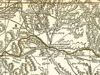
View attachment Arizona Map 1881cr.bmp 1881

1876- Rand McNally Map.jpg 1876

I suspect Robert Tumlinson was actually referring to the "Indian Trail" when he said "Apache Trail".

That trail on the map likely dates back to the Hohokam and was the main trail from their villages on the Gila to the various habitation sites in the Queen Vally area and beyond.

A particular point on that trail, very close to Queen Creek and with the tip of Weavers Needle visible to the north would have made a good choice for a cache location.
But only if high above creek level where flooding could remove any markers as well as the cache itself. Other features could have been mentioned, as well as distances, within a simple set of written instructions.

Regards:SH.
 

Attachments

  • Crook map 1874 telegraph lines.bmp
    1.7 MB · Views: 156

Top Member Reactions

Users who are viewing this thread

Back
Top