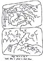
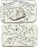
Video 4 - The Peralta Stone Maps with Frank Augustine

My original posting of that excerpt from the letter was an offering of Grace's statement as evidence that at least one copy of the two map stones existed prior to Travis's death in 1961. Travis' paranoia about having the stones stolen had been reported by his friends, thus it seemed reasonable to me and quite likely that Travis had crafted a set himself.....especially since it had been proven he was capable of doing so. It was claimed that tool marks, such as those from a Dremel indicated a modern origin for the stones and, knowing that both Dremel Tools and the duplicator machines made for use with dremel tools were available in this time frame, that it might explain the observations contained within the Desert Archaeology Inc. report to Arizona Highways Magazine for an article published in January 1965. We also have testimony fro Tumlinson family members, as supplied by Azmula in his articles published by the SMHS, of Travis having been seen working on these stones in the front yard of his mother's house, while on vacation in Texas. No mention of Dremel Tools OR a "cloth map" is made by any of these relatives, but it's possible that he was merely adding some of the details or making slight changes to his own "duplicates" and using the "notes on small pieces of paper" as a reference...IMO.

RE:SH.
 

Last edited:
SH

You wrote: " .... but it's possible that he was merely adding some of the details ..." .
I have in my collection two sketches of the stone trail , but the one has a datail more in the heart . May be this the adding on the stones ?

Peralta stones trail map.jpg TRAIL.jpg
 

I'm at the site right now of the holes that Frank and Ryan went to. it's pretty hot out here. I can't seem to find the holes I'm still looking I did discover some treasure an old Budweiser can an old Byerly's non carbonated drink sign don't know how much that's worth but it's worth taking home I've searched the entire area looking for the holes that I found before but I'm still there at the side can't believe my phones working here but I had to reference back to the photo some hiker posted in an attempt to also film the Rockpile and hole. it's quite a ways from the bridge.any help would be appreciated thank you for your patience.
 

well I finally found the right side once I got to the right bridge I got some pictures of it. my personal opinion the did not come from that site there's no way it would have had a blast through solid rock you can't do it..
I'll post more later I'm driving right now there's a car coming at me head on later
 

Last edited:
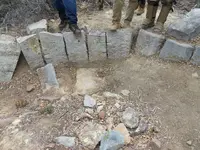
It would have been hard work digging the two grave sized holes Bill, since they are in an area of more densely packed alluvial material and caliche.
Folks have done that and a lot more using pick and shovel though, and the Hohokam dug the pits for their pithouses, as well as their canals using sharpened sticks.
The holes in the other three areas are in a mix of sand and river rock/gravel....not as difficult to dig, since there is less caliche. There is solid rock (bedrock) but it's about 20-30' down. You can see it along the bottom of the south bank of the creek. Post your photos when you get home.

Regards:SH.
 

thanks ryan and frank, nice video and frank does add to it alot.keep up the good work guys and looking forward to seeing and reading.
take care and stay safe out there3.
 

Barry Storm was evidently aware of some discoveries made at QC. In his Treasure Hunter article "Storm Deciphers Peralta Maps"...vol 3 1967... he mentions what he had been told was found and introduced another claimant ( W. B. Morris ) to the ever growing list of "finders" of the stone maps.

View attachment from Barry Stone article QC.bmp

http://freepages.genealogy.rootsweb...mitchell/Storm (Treasure Hunter Magazine).pdf

One other player introduced by Storm at this point is J.W. Cartney, from Grangerville, Idaho. In his letter to Storm, he backs up Morris' claim to having found at least some of the items which were also said to have been found by Robert Tumlinson and his friends. If Cartney's date of 1952 is correct, this would have been only three or four years after the stones were first discovered. It also gives us an clue as to when the larger holes were dug.

Regards:SH.
 

dang and when i thought, i had heard all the finding, of the stones stories
maybe the stone maps makes sense now, my bud Glenn had said the stone
maps were bs, to prob generate a book,story deal, to promote a real estate deal


Barry Storm was evidently aware of some discoveries made at QC. In his Treasure Hunter article "Storm Deciphers Peralta Maps"...vol 3 1967... he mentions what he had been told was found and introduced another claimant ( W. B. Morris ) to the ever growing list of "finders" of the stone maps.

View attachment 1169210

http://freepages.genealogy.rootsweb...mitchell/Storm (Treasure Hunter Magazine).pdf

One other player introduced by Storm at this point is J.W. Cartney, from Grangerville, Idaho. In his letter to Storm, he backs up Morris' claim to having found at least some of the items which were also said to have been found by Robert Tumlinson and his friends. If Cartney's date of 1952 is correct, this would have been only three or four years after the stones were first discovered. It also gives us an clue as to when the larger holes were dug.

Regards:SH.
 

Why would you drive all that way to see something you said you already found

Frank, I haven't seen it in years and wanted to film the other road and older bridge too. Good thing I went and found that old sign it'll look good in my garage!
I did the same thing years ago and went to the wrong bridge.
I spent more time looking at the old bridge location after I saw the first location. Just wanted to remember why I did that. Now I know.
I don't think they came from either location they would be busted up in that crappy hard ground.


Not who Bill....just how many.
It's a traffic counter. :laughing7:

Yup, that's the old bridge on El Camino Viejo, where some have claimed the stones were found.

Regards:SH.
 

I took a bunch of video's yesterday. This is one of them. They're in a small screen format because I didn't turn my phone sideways. It was so freaken hot out there I just wanted to get it done and find the other sites I've looked for the origins of the peralta stone's birth. Personally I think he bought the maps but that doesn't explain why he would put so much time and money into that area on the new highway digging and searching for more maps. I didn't see the two holes 8 paces apart. Here's another video from the old highway by a series of pits dug through the Caliche.


Looks like a little mining was going on at that spot. The holes under the caliche layer is a clear sign. The rock piles another. They were following the pay streak. My guess depression era prospectors scraping up enough gold to survive.
 

Bill, what your referring to as buckets in your video's look like black powder cans to me.
 

Looks like a little mining was going on at that spot. The holes under the caliche layer is a clear sign. The rock piles another. They were following the pay streak. My guess depression era prospectors scraping up enough gold to survive.

You may be right Frank. This area is just past the large mountain to the west of the pull off area on the south side of the road. Along the base of the mountain itself just past the old highway Queen creek bridge is a series of ditches and one large pit. I think there they were trying to capture water for pit maybe a cattle pond but it makes no sense. The cattle couldn't get to it be cause of the brush. I noticed the quartz all over the place had green copper leaching out so it may have been just what you said. The ones in the Video are so close to the road you could end up in one if it was muddy. But this area is exactly the same as the area by Queen Creek and the new bridge. It has the same underlying Caliche with alluvial quartz laying everywhere. The area you and Ryan filmed has a road right to it pretty well traveled like people camp there sometimes maybe hunters. It did look like a good area for arrow head hunting. I never knew about the road so I had to park on the highway. I wasn't there five minutes when a patrol car pulled up asking me if I needed assistance. I said I'm OK and my car was fine but I may need to be committed for hiking in this heat! The kind Officer informed me I couldn't park on highway or would give me a ticket. I left and went to the other older sites first then went back later and parked behind the guardrail at the newer bridge. It was near the end of the day so I never had a chance to film very much there just one of the deep holes and a few shallow ones before I had to skedaddle.
 

If nothing else it's a spot to check out if your looking for a little gold. They would not have put that much effort into the spot unless it was paying. Your correct Bob.
 

Bill, what your referring to as buckets in your video's look like black powder cans to me.

They may just have been black powder cans. I found a few lids later after I made the Video. They had pour spouts for gas or oil maybe? Those things were all over the place. No where to bury any stone maps though.
 

If nothing else it's a spot to check out if your looking for a little gold. They would not have put that much effort into the spot unless it was paying. Your correct Bob.

I went to the wrong bridge the first time. The one further west. Under that bridge was piles of black sands. The article Hiker posted is interesting. It claims the stone maps were embedded in a smelter structure.
I wonder where those old smelters were at?
 

Not who Bill....just how many.
It's a traffic counter. :laughing7:

Yup, that's the old bridge on El Camino Viejo, where some have claimed the stones were found.

Regards:SH.

I know it was just for kicks I said that didn't think anyone would hear it behind the noise from the music.
Later on when I went to the new bridge site there was a car under the bridge sitting there and it looked like someone with Binoculars was watching me.
I'm uploading that video now I'll post it later after these other ones. I still have two more video's one from where the map I posted shows the maps were found by the east side of the mountain on the old highway and another at the Silver King road pull off just past the old bridge.
 

Top Member Reactions

Users who are viewing this thread

Back
Top