Oroblanco
Gold Member
- Joined
- Jan 21, 2005
- Messages
- 7,841
- Reaction score
- 9,876
- Golden Thread
- 0
- Location
- DAKOTA TERRITORY
- Detector(s) used
- Tesoro Lobo Supertraq, (95%) Garrett Scorpion (5%)
I wanted to write another imput, just to complete the alleged " Peralta " stone maps saga. What we have to take in consideration to can make an image on what era those "cities"/caves of gold were created, is what Pope Pius III ( at least was attributed to him ) wrote about this region, about 20 before Spaniards set foot in North America. Many believed Pope's description ( or whomever ) was for the New Mexico region but the encrypted text tells another story.
And here is the text from the book written by Daniel J Duke at https://books.google.gr/books?id=EG...us III about the seven cities of gold&f=false :
View attachment 1801846
IMO, the Soledad peak in this description is Weavers Needle and not Victorio peak or Soledad peak in NM like many others believed. And now , we come back to Celeste Jones map which describes the region of the seven caves of gold in the Superstitions.
View attachment 1801847
You can think " how we know the map is for the Superstitions, because in the map is not depicted any known landmark ", but I would say how in this map exists a symbol which shows where is that region in regards to WN, and also in the map is shown a turtle ( below the eagle ) which is a true landmark ( my current avatar ) that is " looking " at the end of the doted trail from the map.
View attachment 1801848
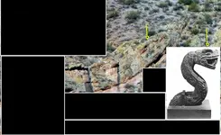
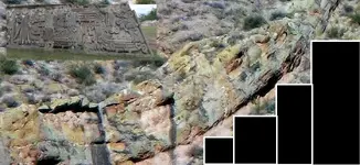
The artist of this map, used this turtle landmark ( maybe was inspired by it ) to mark in the map the treasure caves , and we can see them as a half turtle with its head or as a semicircle with a dot attached in the middle exterior. Here is an GE overlay which shows the turtle's head symbol matching in a sealed door
View attachment 1801853 View attachment 1801854 View attachment 1801855
Like you can see in the map, the five cave's symbols are located W-E ( or vice versa ) with the head of the turtles to point east . There, in this W-E line exists another cave which is hidden by the author, but give a treasure code in the doted trail to can find out the location by counting the dots from the begining of the trail to the " man " and after counting the same number of dots from the junction of the " man " trail with the the curved trail. So, the cave is located at the junction of a line and a trail's " dot " in the upper doted trail's bend. This " hidden " cave with the other next to the west and with the other next to the east, are the three asterisks from the Sleeping Lady map which has the south on top.
And after we would find out the sixth " hidden " cave, we can vindicate the Pope's text which says " three sealed doors to the rising Sol ( true east ) sun and and three sealed doors to the setting Sol ( true west ) sun ", as an orientations of the locations and not of the entrances.
And now remains the seventh cave which is " high noon " ( south ) from the other caves and is the " Casa del Cueva de Oro ". Reminds you something this name ? I believe , for sure. For this cave, the author used a different tresure code, which I wouldn't reveal now, in regards to be find its location in the map and of course in the field. Here is a GE overlay which shows where is located the Casa del Cueva de Oro on the map
View attachment 1801856
And now back to the beginning. IMHO, the "Peralta" stone maps were made for the seventh cave which is within Casa del Cueva de ORO.
Interesting post Marius - and really the only reason we (speaking for the public) use that name Peralta stones is due to common usage, which apparently got stuck on the stones due to an assumption that they must be somehow related to the Peraltas.


 Maybe I might even be able to talk my offspring into making the trip with me when I do try to return to where I have been...Of course I will show them and spoon feed them the information that I hold within my mind...And who knows IF they may see the light...hehehe...