The Square Round Table

Yes, the land and other location factors make whole a lot of sense based on my research.

Regarding my research of the land, I must say that Google is my friend.

The marsh has changed a LOT since when the safes were allegedly buried.
I used Google Earth map "overlays" to help me see those changes.

On a Google Earth map, I overlaid the current way the marsh looks today with a 1910 topographical map image, and also a 1958 topographical map image (both found by using Google and cutting/pasting to Microsoft Paint).
In Google Earth, the overlays can be resized, moved around, and made semi-transparent so you can see the maps right on top of each other. (a pleasant surprise to me)

This showed me clearly and without just eye-balling, some of the inaccuracies in the 1910 topo map, as well as when the marsh changed until it looks like it does today.
So when I am out there I know why some hills are there now (man-made changes for the most part),
and why other hills that were there before are gone (mainly due to water flow changes).

And I can see the land in wintertime from above without the tree leaves covering up the landscape.
All this is really cool.

This also helped me find where the original road was located (it's gone now) that the wagons would have had to use.
And to find the most likely places where they would have unloaded the wagons (based on the story).
My thinking was that they could not have hidden the gold too far away from there!!!

The treasure map is hand-drawn, without much detail at all, and without any compass headings.
So I needed all the help I could get!

If the story and treasure map are based on facts, the author probably made the map vague on purpose, in case the map fell into the wrong hands.
Or, if the story and treasure map were made up, then the author probably made it vague so it would match many places in the area.

Other research I did on the land was:
1. Contacted the historical society of the closest town. Nice ladies, but no help for me.
2. I even ordered a fiction book of the area circa the Civil War time period hoping to find some insight, but didn't. Oh well, it was fun to read anyway.
3. Read any wiki page I thought might help. No help for me finding the target location, but that exercise helped me a lot when I talked with the local historical society ladies.
4. Emailed folks here on TreasureNet.
5. Spoke to old guys (like me) in town about the land and any history of it that they might know of. I did not mention any treasure to them. Ha.
 

Last edited:
Yes, the land and other location factors make whole a lot of sense based on my research.

Regarding my research of the land, I must say that Google is my friend.

The marsh has changed a LOT since when the safes were allegedly buried.
I used Google Earth map "overlays" to help me see those changes.

On a Google Earth map, I overlaid the current way the marsh looks today with a 1910 topographical map image, and also a 1958 topographical map image (both found by using Google and cutting/pasting to Microsoft Paint).
In Google Earth, the overlays can be resized, moved around, and made semi-transparent so you can see the maps right on top of each other. (a pleasant surprise to me)

This showed me clearly and without just eye-balling, some of the inaccuracies in the 1910 topo map, as well as when the marsh changed until it looks like it does today.
So when I am out there I know why some hills are there now (man-made changes for the most part),
and why other hills that were there before are gone (mainly due to water flow changes).

And I can see the land in wintertime from above without the tree leaves covering up the landscape.
All this is really cool.

This also helped me find where the original road was located (it's gone now) that the wagons would have had to use.
And to find the most likely places where they would have unloaded the wagons (based on the story).
My thinking was that they could not have hidden the gold too far away from there!!!

The treasure map is hand-drawn, without much detail at all, and without any compass headings.
So I needed all the help I could get!

If the story and treasure map are based on facts, the author probably made the map vague on purpose, in case the map fell into the wrong hands.
Or, if the story and treasure map were made up, then the author probably made it vague so it would match many places in the area.

Other research I did on the land was:
1. Contacted the historical society of the closest town. Nice ladies, but no help for me.
2. I even ordered a fiction book of the area circa the Civil War time period hoping to find some insight, but didn't. Oh well, it was fun to read anyway.
3. Read any wiki page I thought might help. No help for me finding the target location, but that exercise helped me a lot when I talked with the local historical society ladies.
4. Emailed folks here on TreasureNet.
5. Spoke to old guys (like me) in town about the land and any history of it that they might know of. I did not mention any treasure to them. Ha.

Thanks for sharing that!

I'm definitely interested in your search!

You're right when you said if this pans out to be real it would make a great movie! I really am wishing you success in this..You've sure put in the research of the area.

Please do keep updating... You've got a long weekend coming up, maybe you will hit bedrock.

Do you own this property or know and are working with the landowner?

Kace

Yes, know who owns the land.
When I told them about a safe legend, they said that they are not interested in any safes.
They said so to my face.
They did let me search the marsh.
I really don't want to say any more at this time anyway.

So very sorry Kace and L.C., if I share who owns the property, or how the property is related to the KGC, or even how the property is related to the Confederacy, then folks with Google will know exactly where the marsh is located.
Then I would not stand a chance of retrieving the safes due to other folks searching there, too.

Should I give up because of the bedrock not being close enough to the treasure map, then I would be happy to share everything.
Even un-KGC-believers would give it a try because all the pieces fit together so well (other than the obvious embellishments in the story that even I don't believe).

If all this were a movie, there would be a lot of comic relief with all of my mishaps, misadventures out there, false tries, family criticisms, and me being short, fat, weak, and old.
Just too funny when I think about it.

The exciting thing about the treasure map, to me anyway, is why it says bedrock is 24 feet down.
If I were making the map up, I would say 25 feet or 20 feet.
24 feet is such an odd number (well, an even number, but you know what I mean).

Anyway, let me retrieve some pics from my camera after work today.
I really think folks here would be interested in some of those details.
 

Last edited:
Yes, know who owns the land.
When I told them about a safe legend, they said that they are not interested in any safes.
They said so to my face.
They did let me search the marsh.
I really don't want to say any more at this time anyway.

So very sorry Kace and L.C., if I share who owns the property, or how the property is related to the KGC, or even how the property is related to the Confederacy, then folks with Google will know exactly where the marsh is located.
Then I would not stand a chance of retrieving the safes due to other folks searching there, too.

Should I give up because of the bedrock not being close enough to the treasure map, then I would be happy to share everything.
Even un-KGC-believers would give it a try because all the pieces fit together so well (other than the obvious embellishments in the story that even I don't believe).

If all this were a movie, there would be a lot of comic relief with all of my mishaps, misadventures out there, false tries, family criticisms, and me being short, fat, weak, and old.
Just too funny when I think about it.

The exciting thing about the treasure map, to me anyway, is why it says bedrock is 24 feet down.
If I were making the map up, I would say 25 feet or 20 feet.
24 feet is such an odd number (well, an even number, but you know what I mean).

Anyway, let me retrieve some pics from my camera after work today.
I really think folks here would be interested in some of those details.


Hey Barn,

Please Don't be specific about who owns the land! I'd hate for you to have company to show up...

I appreciate you sharing what you have so far!

I can't wait to hear all the funny things that have happened! Any major project is going to have a lot of setbacks to laugh about later.

I'm still following your story.

Kace
 

Hi All,

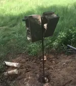
For those interested, here is a picture from my digging for KGC treasure (well, for bedrock) last weekend.

Notice the shade...it was only 90 degrees, but will be close to 100 degrees here next week...and it is still May. Yeow!
The difference is real between 80 and 90 degrees, and a VERY real difference from 90 to 100 degrees. (think sizzle versus open flame)
The tree limbs get in my way when pulling the pipe and auger out of the hole, or putting pipe auger in, but being in the shade is well worth it.
Blocks on dig handle.jpg
The grass in the background just covers mud, you have to pick your steps carefully.
The hole is on the bottom slope of a hill so I can dig better.

The reason the cinder blocks are on the handle of the extendable auger is to push the auger down harder.
Until I hit clay, I don't need them and can scoop the topsoil out about 6 to 8 inches at a time.

The cinder blocks weigh 30 pounds each, so 60 pounds total.
When I hit that dang clay, even with the 2 cinder blocks pushing down, I can only get like 2 inches per scoop.

Since my goal this time is to go past the clay to bedrock, in order to make faster progress, I will buy two more longer (2 feet each) pipes for the handle part, so I can put 4 cinder blocks on the handle at the same time (120 pounds total).
Then maybe I can get 4 inches per scoop.
So many scoops to go down to 24 feet!

The only problem is, lifting the blocks up to the handle many times, and removing them from the handle each time, (and pulling up the dirt, pipe, and water over and over) really gets to my poor back.
Yes, I use my legs as much as I can to lift stuff...but remember I am short, fat, weak, and old.

Oftentimes, after a weekend of digging using the cinder blocks, I really hurt on Monday and Tuesday and can barely walk at all... and have to use a cane (or two).
Luckily I am always well by the next weekend (to potentially hurt my back again)...ugh!

Also, notice my two, white bail pipes to the left side.
I push them down with a small diameter PVC pipe, let them fill up with water, and then pull them up with an attached rope.
Bail, dig, repeat. (my mantra)

Ah, the glamorous life of a treasure hunter in a Texas marsh....hahaha
 

Last edited:
Would not a treasure have been buried on a hill and not in a swampy area? Without knowing where to dig and how deep and what you are seeking, to me is a waste of time and energy but both belong to you.
 

Would not a treasure have been buried on a hill and not in a swampy area? Without knowing where to dig and how deep and what you are seeking, to me is a waste of time and energy but both belong to you.

Yes, Franklin. I agree with your last sentence there about where to dig.

Man, I wish I knew exactly where to dig, too!
Or even if the KGC safes were even there in the first place.

This test hole will serve as yet another piece of my research
(unless I hit a rock and have to start another test hole).

One has to do the best he can with what he thinks he knows at the time.
 

Last edited:
Do you mean you do not have any proof at all that the safes are even there? How did you find out about the safes being hid in the first place ? I hope not some magazine article? Have you searched Official Records of the War of the Rebellion? You can search them for free online with the Cornell University link.
 

Do you mean you do not have any proof at all that the safes are even there? How did you find out about the safes being hid in the first place ? I hope not some magazine article? Have you searched Official Records of the War of the Rebellion? You can search them for free online with the Cornell University link.

Hi Franklin.

Sad to say, I have no proof.
Just found the story in a book.

I guess if there was solid proof, it would be gone now anyway.

I will look up the "Official Records of the War of the Rebellion" with a Cornell University link.
Can't hurt.

But I think I will still dig down to bedrock in any case.
That can't hurt (too much) anyway.

Thanks for the tip.
 

Last edited:
Hi All,

Carrying all my tools through the marsh to the dig site was really hard for me when I was using my contraption to drill/probe in the marsh.
So I started to hide my tools, pipes, generator, 12v deep-cell batteries(2), electric power tools, wrenches, etc. under an evergreen tree that was very full with low branches.
I would even put camouflage nets over everything to hide it better.

The marsh has wild hogs, deer, beaver, etc. on the land....just like the story in the book said.
And so the inevitable happened...poachers stole all my stuff!!! :sad1:
I estimate about $2,000 worth.

So I got a truck bed toolbox, drug it through the marsh, and dug a hole for it on the tallest hill I could find.
I choose a hill so the box would not get flooded when it rained.

During this time frame, I had broken my right hand when drilling a hole in a big pipe using my big 1/2 inch drill.
The drill bit caught on the pipe and spun the drill around super fast and broke a bone in the back of my hand.

So I had to dig a big hole, with surrounding trees (with gosh-dang roots), with a broken hand.
To be honest, getting the gloves on and off was more painful than the digging.
It took me three weeks to dig that hole.

None of my relatives would help me at all with all this foolishness.
I had some resentment about none of my relatives helping me dig that hole.
And I got over it.

I understand that not everyone is cut out to be a treasure hunter.
And treasure hunters don't feel sorry for themselves.
It is our choice to be out there in the first place.

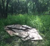
I hid the toolbox under a stack of boards that look like they were just abandoned out in the marsh.
Here is a picture of my boards (the toolbox is still under them).
Wood on ground.jpg

I spray painted the top flat black to make it harder to see if someone disturbed the boards.
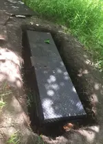
The toolbox and hole:
Black box in Ground.jpg

The toolbox opened up (yes, it has a metal floor, it is just covered up with dirt through use):
Open box in ground.jpg

I hid my tools in that toolbox for over a year.
Then one Sunday, when I was digging (and the box was wide open showing all my tools), a poacher snuck up and surprised me.
He was in his twenties, big, and muscular....and I was in my sixties, short, fat, and old....so I guess he figured I was harmless.

Has asked me what I was doing.
He had already seen my pipe probing contraption.

I didn't want to say I was searching for safes filled with gold, so I said I was looking for methane.
One lie is about as good as another I suppose.

Anyway, he didn't believe me and I didn't care that he didn't.
I figured that he knew where my toolbox was now.
Hence, I am back to carrying my tools to and from the dig site again.

Livin' the dream. :)
 

Last edited:
Do you mean you do not have any proof at all that the safes are even there? How did you find out about the safes being hid in the first place ? I hope not some magazine article? Have you searched Official Records of the War of the Rebellion? You can search them for free online with the Cornell University link.

He has researched but can not talk about it on here Franklin. It is a very good place to be looking where he is at.

L.C.
 

He has researched but can not talk about it on here Franklin. It is a very good place to be looking where he is at.

L.C.

Thanks. If there is a KGC or CSA Treasure buried there, he should be able to find some markings on the trees or diamond shape rocks. There should be something to show where they buried the treasure.
 

Do you mean you do not have any proof at all that the safes are even there?
How did you find out about the safes being hid in the first place ? I hope not some magazine article? ...
Many first encounters with a treasure story do come from a magazine article or a book.
 

Many first encounters with a treasure story do come from a magazine article or a book.

Quote Originally Posted by franklin View Post
Do you mean you do not have any proof at all that the safes are even there? How did you find out about the safes being hid in the first place ? I hope not some magazine article? Have you searched Official Records of the War of the Rebellion? You can search them for free online with the Cornell University link.


He has researched but can not talk about it on here Franklin. It is a very good place to be looking where he is at.

L.C.
 

Thanks. If there is a KGC or CSA Treasure buried there, he should be able to find some markings on the trees or diamond shape rocks. There should be something to show where they buried the treasure.

Hi Franklin,

I have searched for tree carvings, bent trees, rock carvings, and rock clues...all to no avail.

After visiting the area hundreds of times (alas, literally) I can tell what areas have been messed with over the last 150 years.
They all have straight-line hill ridges, flat/unnaturually-sloped, and/or no big trees on them (i.e., the land was cleared).

I do have primary, secondary, and tertiary search areas identified.

My tertiary search area has been screwed up with a man-made boundary and is next to a cleared area.
Maybe I should reverse my search area ordering.

The problem with reversing my search area ordering is that my tertiary search area has no shade.
So I will have to wait until fall for that search area.
If I don't wait until fall I will be cooked alive here in the severe Texas summer weather.

Until then, I can:
1) See if the bedrock is about 24 feet down.
2) Search the other two search areas as they are ordered now....as the primary and secondary areas are shaded, thank God.
(searching for the first safe anyway, safe two and safe three will have no shade regardless...refer to the map I have included in my previous posts in this forum thread that shows where they are...my numbering is that the first safe is the one on the far right in the hand-made drawing)

Of course, if I discover that the bedrock depth is nowhere near where it is supposed to be, I might just give up.
Time will tell if bedrock is around 24 feet down.
(just a matter of days or weeks to determine that, it depends if I hit a gosh-dang rock and have to start over with a new hole)

Looking back, I should have made sure of the bedrock depth two years ago.
I guess I really am as dumb as I look. :laughing7:
 

Last edited:
Hi Franklin,

I have searched for tree carvings, bent trees, rock carvings, and rock clues...all to no avail.

After visiting the area hundreds of times (alas, literally) I can tell what areas have been messed with over the last 150 years.
They all have straight-line hill ridges, flat/unnaturually-sloped, and/or no big trees on them (i.e., the land was cleared).

I do have primary, secondary, and tertiary search areas identified.

My tertiary search area has been screwed up with a man-made boundary and is next to a cleared area.
Maybe I should reverse my search area ordering.

The problem with reversing my search area ordering is that my tertiary search area has no shade.
So I will have to wait until fall for that search area.
If I don't wait until fall I will be cooked alive here in the severe Texas summer weather.

Until then, I can:
1) See if the bedrock is about 24 feet down.
2) Search the other two search areas as they are ordered now....as the primary and secondary areas are shaded, thank God.
(searching for the first safe anyway, safe two and safe three will have no shade regardless...refer to the map I have included in my previous posts in this forum thread that shows where they are...my numbering is that the first safe is the one on the far right in the hand-made drawing)

Of course, if I discover that the bedrock depth is nowhere near where it is supposed to be, I might just give up.
Time will tell if bedrock is around 24 feet down.
(just a matter of days or weeks to determine that, it depends if I hit a gosh-dang rock and have to start over with a new hole)

Looking back, I should have made sure of the bedrock depth two years ago.
I guess I really am as dumb as I look. :laughing7:

Barn, we have more than one proven sight that was pointed to by markers in another state. The intended targets can be miles from the markers, especially when you are dealing with the large caches that were hidden in the 1860's and 1870's with the original intent to be used by the society to fund the second rebellion in its original form. I believe after the late 1870's the society had to reshuffle just as they had done in 1863. By 1904 they to hide assets and regroup again to dodge the FTC and the FCC. Before that, some of the larger caches had been drawn on or removed completely by the society to invest in, and form large monopolies owned by the brotherhood. By 1896 the original hostilities of the rebellion had been transferred to the next generation and subsequently redirected into the "Reconstruction" of the United States to the new societies $atisfaction.

L.C.:icon_thumleft:
 

Last edited:
Barn, we have more than one proven sight that was pointed to by markers in another state. The intended targets can be miles from the markers, especially when you are dealing with the large caches that were hidden in the 1860's and 1870's with the original intent to be used by the society to fund the second rebellion in its original form. I believe after the late 1870's the society had to reshuffle just as they had done in 1863. By 1904 they to hide assets and regroup again to dodge the FTC and the FCC. Before that, some of the larger caches had been drawn on or removed completely by the society to invest in, and form large monopolies owned by the brotherhood. By 1896 the original hostilities of the rebellion had been transferred to the next generation and subsequently redirected into the "Reconstruction" of the United States to the new societies $atisfaction.

L.C.:icon_thumleft:

So even if I somehow find these safes, they might be empty. :sad1:
According to the story, this depository was really big.

The reshuffling of the caches after the Civil War did occur to me previously.
The reason is that the story takes place after the war and
mentions that gold was taken aboard the transport ship at Tampa and Mobile in particular.
The transport ship was supposed to have started out in Virginia.
 

Last edited:
Darn, I was only able to dig on one day this weekend.
I visit my elderly mother every other Saturday.
That is a 2-hour drive each way.

On Sunday, I was able to go to the marsh and dig.
Results below.

On Monday, I was dressed and ready to go the marsh.
On my way out the door, the wife made it perfectly clear that I was not going to the marsh that day.
So I said "Yes, Ma'am" and that was that.

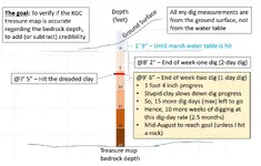
Anyway, here are my results for this week
Week 2.jpg
You can click it to read the tiny words.
 

So even if I somehow find these safes, they might be empty. :sad1:
According to the story, this depository was really big.

The reshuffling of the caches after the Civil War did occur to me previously.
The reason is that the story takes place after the war and
mentions that gold was taken aboard the transport ship at Tampa and Mobile in particular.
The transport ship was supposed to have started out in Virginia.

When I say reshuffle what I mean to say is that they may have retrieved and used certain caches from 1866-1902 in order to use the funds on the stock market and to buy up what they wanted to control from 1903-1912 By that time what they had been doing covertly in the finance world was starting to be recognised by the Federal Government who began looking hard at certain members of the secret society who were coming to light a$ being involved at the top of the pyramids by the Federal Trades Commission and its investigations. Things like cash kickbacks and unfair pricing, as well as banking schemes to collapse the competition etc., had been brought to light and there was litigation that followed for years to come. As in "ALL" cases concerning the K.G.C. and O.A.K., there were no convictions due to lack of evidence to support the Federal Governments accusations. Let's just say, when you have the president of the U.S.A. going to bat for you in a Federal courtroom, it will get you off pretty easy!:icon_thumleft:

P.S. That would eventually include the salt and breakfast cereal on the kitchen table in every home in the U.S.A. and other countries we exported to.https://books.google.com/books?id=W...Paul Morton Federal trades commission&f=false


Paul Morton, J. Gould, J.P. Morgon and Teddy Roosevelt all working for cash money and the cover-up together. https://books.google.com/books?id=l...ved=0ahUKEwjX17rNiqrbAhWP14MKHel8CacQ6AEIODAB


https://www.marxists.org/archive/debs/works/1907/1907-roosevelt.htm


and then... http://www.smokershistory.com/guaranty.htm
 

Last edited:

Top Member Reactions

Users who are viewing this thread

Back
Top