The Square Round Table

Well...You've really thought this out... I'm glad to see that you do have help!

If you've read anything at all that I've written about Orvus Lee Houk you know I don't believe a word he has ever said. That's just my opinion. I respect others beliefs though and truthfully I'd like nothing more than to be proven wrong about this. I mean that and am wishing you great success.

I'd really like it if you would post updates and photos of your project. You would be the first ever to find and recover a major KGC depository. I'd definitely follow the thread! I'm sure others would too. You Would Make History, That's For Sure!

I do have a question though... How did those safes get to this marshland according to Orvus?

Good Luck and Keep Posting About Your Progress.

Kace

Hi Kace,

The story of how the safes got there is all in that ridiculously expensive book that I referred to in my post before:
https://www.amazon.com/gp/product/0972307265/ref=oh_aui_search_detailpage?ie=UTF8&psc=1
The Mysterious and Secret Order of the Knights of The Golden Circle (Volume 1) Paperback – March 1, 2005
by Dr. Roy William Roush Ph.D. (Author)

Using old maps, I researched the path taken by the ships, the gold transfer cities, the path taken by oxen drawn wagons, etc.
All the routes and cities all match up with historical places at the time.
(which Orvus Lee Houk could find on old maps if he wanted to make up a story)

Dynamite was invented in 1867 and was used to blown up a dam that ruined Port Jefferson in 1872.
So *IF* the story is true, the safes must have have been moved prior to 1872, as Port Jefferson was key to the route taken.

I did notice that the type of wood (cypress) mentioned in the story matches up with Caddo Lake State Park (on their path) that is known for cypress wood.
Also I discovered that there was a drought in Texas in 1870... which would probably allow holes to be dug in the marsh land, with the hollowed out cypress logs (that hid the gold in the wagons) used for material to shore up the sides of the hole shafts.

The specific marsh land where am searching also had very strong ties to the Confederacy (per confirmed history) and also had ties to the KGC (as I learned from another respected member of this forum).

Interestingly, I calculated how much weight those oxen team drawn wagons could have reasonably hauled in hot Texas weather.
The weight they could have hauled matches the amount of gold reported in the story (taking into account all the other stuff the oxen would have had to haul... like hollowed out logs, men, supplies).
(you must be really smart or lucky to figure this out if you were making up the story... I am sure Orvus Lee Houk was NOT that smart nor lucky)
This also helped me calculate the smallest dimensions the safes had to be. (3X3X4 feet at least, given the thickness of the safe walls)

I did find a few problems in the story that does worry me.
1) The references to Jefferson Davis seem stupid and unnecessary.
2) One of the cities mentioned on the path was officially incorporated in 1895, although the story *could* have been written after that date.
3) Using block and tackles to lower the safes into the holes seems very hard to believe, as the safes loaded with gold would have been way too heavy, even with oxen doing the work. Seems to me the safes should have been lowered empty first, then filled up a little at a time. Maybe the writer of the story got his information second hand and got some of details wrong (or made some stuff up).

Or, maybe Orvus Lee Houk had access to old maps, knew about the Port Jefferson area, knew about this marsh land somehow, and made up the story/map.

Anyway, I have searched for treasure before and been disappointed, yet lived to search another day.
 

Last edited:
Never underestimate the abilities of people to move, lift or build things 150 yrs. ago. When we built an addition onto our house, we got into the foundation of the house that was there before. Cut sandstone 1'X 11/2'X 7 or 8'. It took 2 backhoes to get it out. One couldn't lift it into a dump truck. We talked about it at the time. How did they get that into the foundation? An old timer suggested "Jim Poles" and teams.
When the Co. I worked for moved, their office safe had to go. 3'X3'X4' on rollers. The boss told the mover he could get some help to move the safe. The office was on second floor and no elevator. The mover squatted like a catcher, put one hand under the safe and one on top and lifted the safe high enough to see under it and said"the boy and I can move it, no problem.", and they did.
Good luck.

Hi Uglymailman (what a great moniker, ha!),

Yes, humans are really creative.
There was some show on TV where one man proved that he alone could build stonehenge.
For example, he used a little stone under huge rock weighting tons to turn the huge rock around with one hand!

Currently, I dig with an extendable Seymour General Purpose Iwan Auger hand auger.
I can go down like 5 feet at a time before the hole sides start caving in uncontrollably.

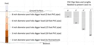
So after 5 feet, I then put down PVC pipe to prevent cave-ins.
Then I use a smaller diameter auger to go another 5 feet, and then stuff in a smaller diameter PVC pipe.
My auger sizes are 8", 6", 4", 3", 2", and 1"
I repeat with the ever-smaller auger sizes until I hit a rock (then I have to stop digging that hole, bummer) or until I reach the depth I want.

All the holes fill back up to near the top with water fast in this sandy marsh... even with PVC pipe lined sides.
If there is water in the hole, then the sandy soil melts on the way up as you pull the sand out of the hole.
So I use a short PVC pipe (with a capped end) and a rope to bail out water from the hole as I dig (so bail, dig a scoop, repeat).

50ish more holes is my target before I give up.
At a rate of about 1 hole a week (max) using my current methodology, that is over 4 more years...very uncool.

Hence, I am looking for someone more creative than me to figure out how to "see" under 24 feet of marsh land for a safe.
In a previous post, a magnetometer was suggested.

I called the tech support folks at Geometrics Inc. who make a powerful, yet rentable, magnometer (G-859 Magnetometer, $20k to buy)
He said that with the depth and type of soil I am searching in, there is only an 80% chance (max) that I could even detect the safe with the G-859.
The rental price I figured I could handle, but I could not get the required insurance to rent it anywhere. (I called like 10 insurance places)

Looking for the next best thing, I also contacted AlphaLab, Inc. to rent their cheap Earth Magnetometer Model EM2.
You can rent an Earth Magnetometer Model EM2 ($780) for a month for $260 (plus shipping) and the rental can be applied to purchase price if you decide to buy it.
I fear that the cheaper EM2 just can't do the job when even the powerful G-859 would have trouble.

However, after all that, the wife nixed the magnetomer idea flat out, even for renting the cheap EM2.
From her perspective this is all foolishness and she says I have spent way too much money on this "stupid project" already.
This is why there are so few married treasure hunters in the world. Ha!

So I guess I will save my loose change for a year until I get enough for the cheap EM2 (which probably won't work anyway) on my own.
 

Last edited:
Well, I guess that we know why the old prospectors came to town once in a Blue Moon and cashed in some of their gold for supplies.

brothel.jpg
 

Hi Kace,

The story of how the safes got there is all in that ridiculously expensive book that I referred to in my post before:
https://www.amazon.com/gp/product/0972307265/ref=oh_aui_search_detailpage?ie=UTF8&psc=1
The Mysterious and Secret Order of the Knights of The Golden Circle (Volume 1) Paperback – March 1, 2005
by Dr. Roy William Roush Ph.D. (Author)

Using old maps, I researched the path taken by the ships, the gold transfer cities, the path taken by oxen drawn wagons, etc.
All the routes and cities all match up with historical places at the time.
(which Orvus Lee Houk could find on old maps if he wanted to make up a story)

Dynamite was invented in 1867 and was used to blown up a dam that ruined Port Jefferson in 1872.
So *IF* the story is true, the safes must have have been moved prior to 1872, as Port Jefferson was key to the route taken.

I did notice that the type of wood (cypress) mentioned in the story matches up with Caddo Lake State Park (on their path) that is known for cypress wood.
Also I discovered that there was a drought in Texas in 1870... which would probably allow holes to be dug in the marsh land, with the hollowed out cypress logs (that hid the gold in the wagons) used for material to shore up the sides of the hole shafts.

The specific marsh land where am searching also had very strong ties to the Confederacy (per confirmed history) and also had ties to the KGC (as I learned from another respected member of this forum).

Interestingly, I calculated how much weight those oxen team drawn wagons could have reasonably hauled in hot Texas weather.
The weight they could have hauled matches the amount of gold reported in the story (taking into account all the other stuff the oxen would have had to haul... like hollowed out logs, men, supplies).
(you must be really smart or lucky to figure this out if you were making up the story... I am sure Orvus Lee Houk was NOT that smart nor lucky)
This also helped me calculate the smallest dimensions the safes had to be. (3X3X4 feet at least, given the thickness of the safe walls)

I did find a few problems in the story that does worry me.
1) The references to Jefferson Davis seem stupid and unnecessary.
2) One of the cities mentioned on the path was officially incorporated in 1895, although the story *could* have been written after that date.
3) Using block and tackles to lower the safes into the holes seems very hard to believe, as the safes loaded with gold would have been way too heavy, even with oxen doing the work. Seems to me the safes should have been lowered empty first, then filled up a little at a time. Maybe the writer of the story got his information second hand and got some of details wrong (or made some stuff up).

Or, maybe Orvus Lee Houk had access to old maps, knew about the Port Jefferson area, knew about this marsh land somehow, and made up the story/map.

Anyway, I have searched for treasure before and been disappointed, yet lived to search another day.


As long as you're having fun and have all information, which it sounds like you do... I really hope you find all that you are seeking! I'd love it!

Dalton was in Longview, Texas in later years. Orvus could of gotten info from him. I'm thinking he was in other parts of Texas too...Have you read the Crittenden Memoirs? If not look for the section by Frank Dalton.

Be Safe and Have Fun With Your Hunt!...Please keep us updated on your progress.

Kace
 

Hi Barn, you can call me ugly. If I've got this right you need to punch 20 some holes 24' deep? What you need is a drill rig.
I'm going to try and describe a movable drill rig I've had experience around. I spent 10 yrs. as a surveyor at a coal co.. One of the jobs was to follow the prospect drillers to locate the holes they punched. Some were on a 2 ton truck and could take 10" dia. cores or 2" cores or just drill and watching the cuttings coming up and resistance could tell you depth to the coal and what and how thick the strata above it was. They could go about 300' deep with cores up to 120' or so. There were also rigs on a pickup with a 10' boom that would lie down over the cab. These could take 2" auger until it hit rock or maybe 10' around here. They could take a 2" core but would bend the core casing at anything over 4' or so. But the one I want to tell you about was called a "jitterbug" drill. A guy that was handy could probably build one.
The drill was movable and had 2 wheels about the size of a lawn tractor that were removed to sit up the drill. It was pulled by farm tractor or pickup. The frame was tubular and approximately 2 1/2' wide and 4' long. In the middle of the frame was about a 10 hp engine (bigger than my 24 hp lawn mower but that was in 70's/80's and I'd guess they had been in use 30 yrs.). The boom was hinged and when in the vertical position for drilling was about 8' tall. The boom was made of 2 tubes 6-8" apart and the drill pipe was located between the two. The drill pipes came in 10' lengths and were 1" I.D.. a hole 1' cube was dug directly below the drill pipe and filled with water. A 25 gal. oil barrel with a garden hose was filled next to the hole. When the engine was fired up it forced the drill pipe down and twisted it at the same time. As I remember, it slammed the pipe down about an inch at a time. The water in the cube hole was kept full of water and as it drilled it forced water up the inside of the pipe and out and the drill operator caught the cuttings in a tea strainer to read the cuttings.
I tried goggling jitterbug and other prospect drills and had no luck but you get the basic idea.
I'll leave you with a couple of questions. Do you know the safes are at 24'? Do you know where bottom is and could the safes keep sinking? The reason I ask is I once set a 3' long 6" dia. concrete survey marker (100 lbs) in river bottoms. As this was going to be covered with water from a U.S. Corp. Eng. lake we got away with it. We dug the hole and set the marker. We left it 2" above the ground as per requirements. We then waited 15 mins. as we watched the marker. The crew chief wrote in the logs "when last seen it was still sinking but this monument will be inundated." We watched it sink 8" deeper than we dug the hole and get covered with water. If there is no hard clay,shale or rock, that safe might not be to the bottom yet. Good luck.

Hi Ugly,

Yes, I had thought of a drill rig before. The issue was that anything half-way heavy, like a pickup truck, would simply just sink.
I thought of a small excavator (on tracks) with an extendable hydraulic dig bucket, but that would still be too heavy (not to mention having a lot of side wall area to shore up to prevent cave-ins as it digs down).

Remember, the water level in this marsh rises to the top of any holes dug, and so a bob cat can't be used, else it would go underwater. (yikes!) Even my 3 inch pump couldn't keep up with such a big hole that a bob cat would have to make to go down 24 feet.

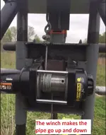
I did have built a 12V "winch powered probe machine" that luckily didnt sink.
Originally, I tried a big power drill (with a generator for power and a torque multiplier) to drill down with extendable 4 foot rods...the max I was able to attain was 12 feet.

Then I modified the contraption to using 4 foot pipe sections to push pipe probes directly into the marsh. Alas, the lower down I got the higher the pressure. I couldn't get down more than 16 feet with 1 inch pipes (4 foot sections) before the pressure against the pipe was simply too great even for a big heavy duty winch. And if I ever hit a big rock, then the winch cable would break (even a very heavy cable...very scary and loud when it happens).

Here are a couple of pics you might enjoy...

How the winch worked making things push down and pull up -
Untitled.jpg

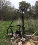
Here is an old pic with my drill before I switched to pipe -
IMG_0066.jpg

Using pipes, the structure would rise when pushing the pipes down, and sink when pulling the pipes up.
So, I used four 4 foot land anchors (like they use on mobile homes) and chains to hold the structure down when pushing pipe sections down.
And to keep it from sinking when pulling the pipe sections up, I had to put the structure on rail road ties.
BTW, even cutting rail road ties in half, it about killed me dragging them through the marsh (one at a time) to get to the dig site. (yes, I am old)

When pulling this contraption on it's two wheels, it looks sort of like I am pulling a rickshaw, so I named it "winch-shaw". hahaha

From the story, I calculate that each safe would weigh about 7 tons each. (more than a large truck or SUV)
I guess they could have sunk further down, but at 24 feet down, there is a L-O-T of pressure in the ground, so I don't think they would sink without a lot of sideways movement or anywhere for the soil to displace to (like there would be nearer the surface).

The reason they could get the safes out there and buried originally was due to a multiyear dought around 1870. I have been out there during July and August and the ground is as hard as rock.
 

Last edited:
Hey Barn. That rig is pretty close to what I described. The jitterbug's drill bit was at one end of the frame, not in the middle like yours. Think like a bicycle frame on both sides or like the handles on a portable generator. It had shorter,wider tires. I'd guess it weighed in the 300 lb. range. 2 guys could move it a short way and one man could tip it far enough over to remove a wheel.
The pics look VERY much like where we had the sinking monument. One crew got stuck in a 4wd suburban too far away from a big enough tree to use winch. Called us to get em out. Took about an hr. to get there. When they quit tryin to get out, they could open the doors on the truck. When we got there the bottom of the door was 4" below ground level. I don't know if we could have found it if we'd let it sit all night. Good luck.


YIKES!


Oh, I just reread the legend and looked at the map for the millionth time.
The story in that book says the safes rest on bedrock.
So if the story is true, the safes would not sink after all.
I had forgotten that.
The mind is the second thing go when you get old, I suppose. :unhappysmiley:

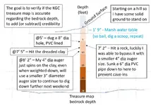
Here is the map again, with "bedrock" mentioned under it.
IMG_0066.jpg

I usually stop digging my holes when I hit a rock (and have to stop) or hit clay.
My thinking is that if I hit clay, then I am in the wrong place, since when they refilled the hole they would have used sand and easier to lift, not stupidly sticky and heavy clay.

So the next hole I dig, even if there is clay, I should just continue until I hit bedrock to determione if bedrock is more than significantly 24 feet down.
That would help to determine if the story is bogus or just might be true after all.

I was not able to dig at all this weekend, as the fates were simply against me at every turn.
But I should be able to determine how far bedrock is in a couple of weeks or so by digging a test hole.

There would be no other reason I can think of why anyone would dig down to bedrock in a marsh.

Thanks for the reminder, Ugly.
This forum has been a tremendous help, and I hold all you guys in high regard.
:icon_thumright:
 

Last edited:
For those interested in following along, I did dig this weekend.

No time for me to post pics or the troubles I encountered.
I only got a little over 8 feet.

I will have to think how to post my progress, or lack of progress, in line with my plan of finding if bedrock is really 24 feet down, like the treasure map says.
Anyway, my plan is this.

PVC Pipe Sizes.jpg

More later
 

For those interested in following along, I did dig this weekend.
I discovered you can click the picture to show it larger.

My digging progress.jpg
 

I'd be looking for the iron targets first, Safe(s)/Meteorite is worth something.
Then dig.
 

For those interested in following along, I did dig this weekend.
I discovered you can click the picture to show it larger.

View attachment 1592822

I'm definitely following along!!

This is way cool to see your plan in action!

How did you decide what area of this sq. Mile I think you said it was to drill your holes?

Thanks for posting Barn!!

Kace
 

I'm definitely following along!!

This is way cool to see your plan in action!

How did you decide what area of this sq. Mile I think you said it was to drill your holes?

Thanks for posting Barn!!

Kace

Hi Benjamin and Kace,

I am on my 3rd year searching in the marsh area.
I have been out there well over 200 times.
Many months were spent eliminating places that did not match the treasure map.
Many more months were spent trying to use technology that just wasn't good enough for this particular search area.

Pulse induction didn't work for me (I bought a PI detector with a huge 4-meter square coil to go way deep, very expensive and turned out to be worthless out there).
I am being told that gradiometers, magnetometers, and resistivity technology won't work either due to the environment out there.
My pipe probing contraption, very expensive to have built paying a machinist to design and build it, was a bust, too.

The area is really big, swampy, filled with salty water/mud, soil permeated with hematite, iron ore rocks abound, iron slag in some places, and the target area is over 20 feet down.
Sheesh, I couldn't have picked a better place to foil treasure hunting technology or discourage efforts to find the safes.

Anyway, enough of my whining.

I am down to a primary, a secondary, and a tertiary target area, all of which are the best matches the vague hand-drawn treasure map.
All 3 areas make sense, given where a historical road was located through the marsh during the civil war.
No, the old road is not there anymore, but I definitely found where the old road was.

All three of my search areas are very close to each other.
All together they total about 50-ish potential hole places with which to grid-dig the area.
My grid holes are about 2 feet apart from each other.
I haven't measured, but my guess the irregular shaped grid area totals up to an area of about 1500 square feet (just a guess).

So to dig this particular test hole to bedrock, I simply selected one of those 50ish places.
I definitely selected a hole in the shade, as it is 90 degrees during the day now, and will only get hotter through the end of August.

I have dug several holes so far.
It takes me a week to dig one hole.
And normally, I stop digging when I hit the dreaded clay (or hit a stewpid rock).
My thinking is that if they buried a safe, they would have dug through the clay, buried the safe, and refilled the hole using topsoil (and not using hard-to-handle dang clay).
Maybe I am wrong in that assumption.

Anyway, I didn't stop when I hit the clay this time because I am trying to better determine odds of the treasure map being true or not.
The odds of the map being true go up if the bedrock is 24 feet down (or so) like the map shows.
The odds of the map being true go down if the bedrock is clearly at a different depth.

If the odds go up, I will likely continue.
If the odds go down, I may just give up.

I just hope that I don't hit a rock, and have to start with a new test hole.
If I do, I still have about 50 holes left where I can start anew to determine the bedrock depth.

Thanks all for your interest.
 

Last edited:
WOW!...Thanks Barn... keep updating, very interesting.

Kace
 

Barn, would you tell the history of the land you are searching if you don't want to keep it a secret? That is the part that made my hair stand up on the back of my neck.:icon_thumright: Very cool stuff you are doing, I am following you for sure.:occasion14:

L.C.
 

Barn, would you tell the history of the land you are searching if you don't want to keep it a secret? That is the part that made my hair stand up on the back of my neck.:icon_thumright: Very cool stuff you are doing, I am following you for sure.:occasion14:

L.C.

I asked the same question and if you go to page 9, Barn explains the land and that he got the info/map from Rousch (who took it from the Black Book). The Mysterious and Secret Order of the Knights of the Golden Circle. Barn said the book was ridiculously expensive.

Kace
 

I asked the same question and if you go to page 9, Barn explains the land and that he got the info/map from Rousch (who took it from the Black Book). The Mysterious and Secret Order of the Knights of the Golden Circle. Barn said the book was ridiculously expensive.

Kace

Thank you, Kace.
Yes, the book is horribly put together and horribly expensive.
Luckily I just was interested in just a few pages. :unhappysmiley:

In my search for the marsh, studying the route taken in the story, researching KGC/Confederate history, and researching/scouting the county mentioned personally
I believe that there is just one marsh that matches the story (if the story is true, or based on true events anyway, as I am almost certain the story was embellished and written down after 1895).

The only reason I am so single-minded regarding this particular cache is because this is the only KGC cache I could find (in theory) within driving distance to my house (45 minutes each way).
I knew it would take a really long time to find and/or recover (if the story is true).
So taking 3 years isn't so bad.

Let's see if I hit bedrock at 24 feet or not.
If I give up the quest, I will be glad to share everything I have learned or discovered.

It would make on heck of a movie if it turned out to be true...haha
 

Last edited:
I asked the same question and if you go to page 9, Barn explains the land and that he got the info/map from Rousch (who took it from the Black Book). The Mysterious and Secret Order of the Knights of the Golden Circle. Barn said the book was ridiculously expensive.

Kace

I read that, but it is not what I am talking about. It gets better.

L.C.
 

Top Member Reactions

Users who are viewing this thread

Back
Top